#rfmap by lepton software
Explore tagged Tumblr posts
Visit Tumblr Blog
Explore Tumblr blogs with no restrictions, modern design and the best experience.
Last Seen Tumblr Blogs


Fun Fact
BuzzFeed published a report claiming that Tumblr was utilized as a distribution channel for Russian agents to influence American voting habits during the 2016 presidential election in Feb 2018.
Text
RF Planning for 5G Networks: Challenges and Solutions
The advent of 5G networks guarantees low latency and massive connectivity, transforming communications. However, maximizing the capability of 5G requires meticulous planning for RF. This article focuses on the troubles and solutions related to RF plans for networks that help 5G. It focuses on important factors like 5G network , RF planning software, in addition to telecom management software for networks.
Click to read more about RF Planning for 5G Networks: Challenges and Solutions
#rf planning#RF Planning#rfMAP#3D Maps#Digital Map#Wireless Maps#Telecom#5G Networks#Network Planning#3d Network planning#fiber planning#fttx#rf maps by lepton#lepton software#lepton maps#2.5D Maps#Map Data#rf planning tool#network coverage#3d map
0 notes
Photo
Visualize earth in the most immersive way possible with the precise rfMaps solution by Lepton Software. Create 3D visualization, run simulations, and develop dynamic location-based experiences. Talk to our experts to get a detailed understanding: https://bit.ly/3LQggzG #LeptonSoftware #maps #rfmaps #3D #GIS #locationintelligence #datavisualization #software
0 notes
Text
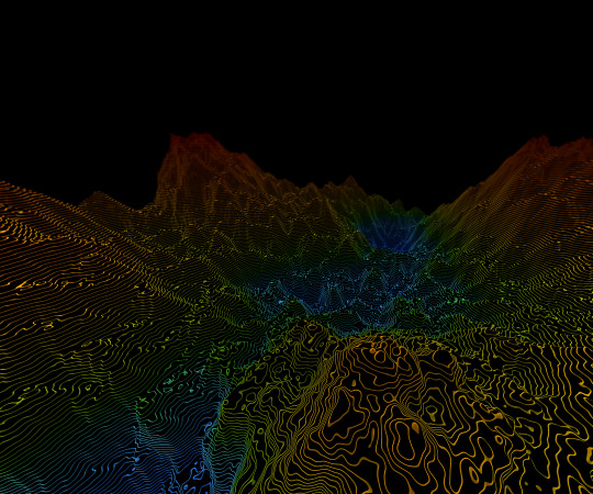
DIGITAL ELEVATION TOOL
With the growing demand and importance of Digital Elevation data,it has become easy to depict the particular region.Let’s understand the meaning of Digital elevation data. These data are the sets of elevation measurements for locations distributed over the land surface. Elevation data have many practical uses ranging from environmental to urban & many more. Basically,a topographical map is the main type of map used to depict elevation,often through the use of contour lines.
In Geographic Information System,digital elevation models are commonly used to represent the surface topography of a place, through a raster grid data set of elevations.The representation of continuous elevation values over a topographic surface by a regular array of z-values, referenced to a common vertical datum. DEMs are typically used to represent the bare-earth terrain, void of vegetation and manmade features.
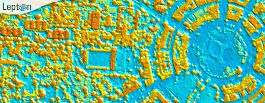
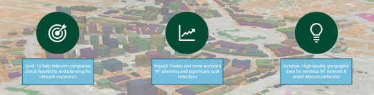
rfMap is a product by Lepton Software, a leader in geodata for wireless network planning & optimization used in the Telecom industry. Our USP is creating high precision RF geodata around 3D Maps, 2.5D maps, 2D Maps with multiple layers of Clutter, DTM, DSM, building footprint with Height & a wide range of solutions.The major goal is to help telecom companies to check feasibility & planning using high-quality rfMap which makes the process faster, accurate & reduce cost. Using a digital map to plan your radio frequency coverage will ensure that every subscriber can access your network in an area of interest.To ensure that you can easily plan your RF network, we provide the map data to help optimize your network planning and optimization which is DTM – Digital Terrain Model or height data provides a topographic model of the bare earth/ underlying terrain of the earth’s surface.It is a crucial dataset that helps in Line-of-Sight analysis by determining potential obstructions to radio signals.It’s source is High Resolution Stereo Satellite Imagery, ALOS/ASTERGDEM/SRTM and Topographic Maps.
0 notes
Text

Join Lepton Software at India Mobile Congress 2024, (Official GIS Partner) as we showcase our GIS-Powered Telecom Solutions.
NetworkAccess - Fiber Planning & Design SmartCampus - 3D network planning rfMAP - 3D/2.5 Maps Coverage, RF Planning Tool. Click to learn more: https://leptonsoftware.com/
#lepton at imc 2024#lepton software#imc 2024#india mobile congress 2024#telecom events in india#telecom event#5g planning#fiber planning#network optimization#gis tools#gis software#gis solutions
0 notes
Text
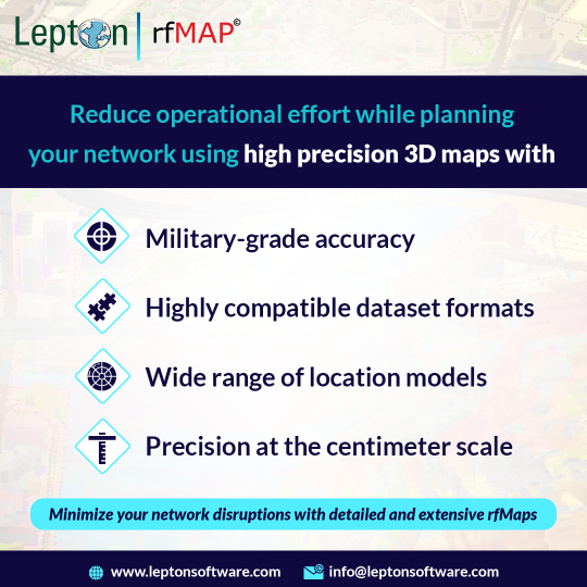
rfMap by Lepton Software (2d, 2.5D, &3D Digital Maps)
Lepton Software's rfMap is a powerful and user-friendly web-based tool designed for network engineers, planners, and operators to visualize, analyze, and optimize radio frequency (RF) networks. It offers an intuitive interface that simplifies the complex process of network planning and management, providing users with an easy-to-use, comprehensive solution that enhances network performance and reduces operational costs.
rfMap by Lepton Software is a highly customizable tool that supports a wide range of wireless technologies, including 2G, 3G, 4G, and 5G, as well as Wi-Fi, microwave, and satellite. It provides a detailed view of the network's coverage, signal strength, interference, and quality, allowing users to analyze and optimize the network's performance based on real-time data.
The tool also offers advanced features such as multi-level zoom, heat maps, and multi-layer network analysis. The heat maps enable users to visualize the signal strength and coverage of the network in a specific area, while the multi-layer network analysis provides detailed information on the network's performance, including throughput, latency, and packet loss.
rfMap by Lepton Software also comes with a built-in prediction engine that enables users to simulate various network scenarios, such as adding or removing base stations, changing antenna heights, or adjusting the power and frequency allocation. This feature enables network operators to test different scenarios and optimize their networks for maximum performance and efficiency.
rfMap by Lepton Software is a cloud-based solution that offers seamless integration with third-party data sources, such as GIS, network management systems, and data warehouses. It provides a secure and reliable platform that ensures data privacy and integrity, enabling users to collaborate and share data with ease.
In conclusion, rfMap by Lepton Software is a versatile, scalable, and comprehensive tool that provides network engineers, planners, and operators with a powerful platform for visualizing, analyzing, and optimizing their RF networks. Its advanced features, user-friendly interface, and cloud-based architecture make it an ideal solution for businesses of all sizes looking to enhance their network performance and reduce operational costs.
#rfmap by lepton software#rfmaps#rf planning#2d maps#2#5d map#3d map#5g planning#wireless maps#telecom
0 notes
Text

Visualize with clarity and create dynamic location-based experiences with fast, cost-effective rfMaps Planning Software by Lepton Software. Minimize network disruptions and access high-quality geodata. Schedule a demo:
0 notes
Text
rfmap: A Lepton Software Solution
rfMap is a product by Lepton Software, a leader in geodata for wireless network planning & optimization used in the Telecom industry. Our USP is creating high precision RF geodata around 3D Maps, 2.5D maps, 2D Maps with multiple layers of Clutter, DTM, DSM, building footprint with Height & a wide range of solutions.
The major goal is to help telecom companies to check feasibility & planning using high-quality rfMap which makes the process faster, accurate & reduce cost. Using a digital map to plan your radio frequency coverage will ensure that every subscriber can access your network in an area of interest.To ensure that you can easily plan your RF network, we provide the following map data to help optimize your network planning and optimization:
1. DTM: Digital Terrain Model or height data provides a topographic model of the bare earth/ underlying terrain of the earth’s surface.
2. Clutter Data: It stores information about the coverage of earth surface such as settlement & habitation, water bodies, agriculture land.This data simplifies the RF planning process by showing the distribution of urban and residential areas. Estimation of population density is important in allocating resources for optimal network coverage.
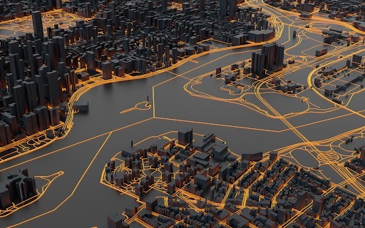
3. Road Vectors: It contains all the road, rail, metro & water networks. Operators use this data to plan & improve the network coverage along the roads.
4. Population Map: The population distribution & projection will be done considering the spread of settlements, local census & the growth rate.Based on population data, its density and average usage, base stations and other locations can be mapped on a 3D interface to minimize obstructions to your network’s signals.
5. 3D Map Dataset: Highly accurate Raster and Vector 3D Map dataset at 1-meter resolution consisting of height for individual buildings, trees, elevated objects.
6. With the help of 3D Model extra-accurate high-resolution databases for 3G/4G/LTE/LPWAN/IoT networks planning in densely built-up areas are taken care of.It provide precise Digital Terrain Model and above-ground features such as buildings, vegetation and engineering constructions.3D Models Data Set consist of: Population Data, DTM, Clutter/land user model & Geo Data
0 notes
Link
https://www.leptonsoftware.com/blog/rfmap/ rfMap is a product by Lepton Software, a leader in geodata for wireless network planning & optimization used in the Telecom industry.
0 notes
Link
#rfMap is a product by Lepton Software, a leader in #geodata for wireless #networkplanning & optimization used in the #Telecomindustry. Our USP is creating high precision #RF #geodata around #3DMaps, 2.5D maps, #2DMaps with multiple layers of Clutter, DTM, DSM, building footprint with Height & a wide range of solutions. Read know More :- http://bit.do/eJpx8
0 notes
Link
Get most extensive GIS Software and applications with Lepton Software. Leading location intelligence, 3D Maps google maps and google cloud platform solutions." gis software,gis software and applications,3d maps,geodata,network planning,network inventory,rfmaps,rf maps,cloud hosting,leading location intelligence,3d maps google maps and google cloud platform solutions.google maps partner,google cloud partner
0 notes