
atlurbanist
ATL Urbanist
Darin Givens is co-founder of ThreadATL, an urbanism advocacy group.
ThreadATL.org | [email protected]
3491 posts
Don't wanna be here? Send us removal request.
Last Seen Blogs

angxlwiings
STARCHILD: ARE YOU LISTENING?🕊️

carlospacheco
Carlos Pacheco

actsofwar
death descends upon us all

carakook
Carakook

singhragh
Unti+
Text
Build rail for tomorrow's city, not today's
Darin Givens | April 23, 2024

There are many logical reasons to cast a critical eye on the streetcar extension to the Eastside Beltline, and we should never spend this much money without arguing.
But folks, please stop acting like we can only build rail for the current conditions in a place -- this wrong assumption is the foundation for too many arguments against Beltline rail. We should build rail for the future version of Atlanta.
Obviously, we've screwed up in the past and built rail for "current conditions" and not for walkable growth, and that's a set of mistakes we should remember...
We built the MARTA heavy-rail system to serve as commuter lines to a Downtown Central Business District as it existed in the 1970s, but the system ended up being dwarfed by both job sprawl and residential sprawl, while too many of our rail stations were ensconced in parking lots and low-density development.
And we built a streetcar for tourists that runs mostly empty throughout the week because we included no walkable-density plan, leaving it surrounded by too many parking lots and empty properties -- and saddling it with interstate access points that challenge walkability.
So let's learn from our mistakes and start matching investment in high-capacity transit with transit-supportive density for the future. Is the Beltline a great place for doing that? I think so. It's a growth corridor, and the route is level for rail with only a few tricky intersections.
I think it's absolutely a good thing for people to disagree and have healthy debate about this, but the debate needs to be informed by the fact that building rail for current conditions is a mistake, as evidenced by our past, and that remedying that mistake means thinking about high-capacity transit in a new way.
Opposing Beltline rail in terms of what the conditions are on the corridor today is a bad faith argument. It's unfair to the future of the city to burden it with more of that same problematic planning decisions of the past.
20 notes
·
View notes
Text
Automobiles and racist housing practices are intertwined in Atlanta's history
by Darin Givens | April 21, 2024
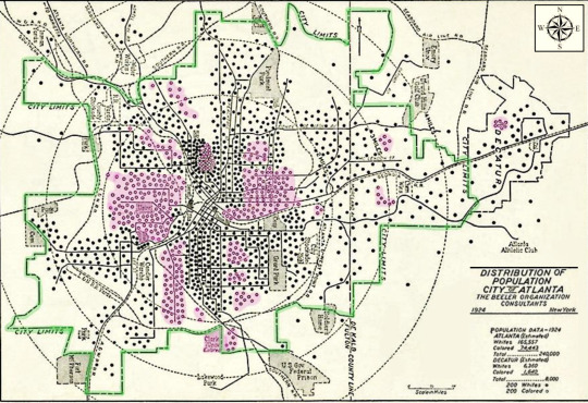
This is a map of the racial distribution of the population of Atlanta in 1924. African American areas are highlighted in light red, and the city limits in green.
This comes from an excellent 2021 dissertation called "How the Car Won the Road: The Surrender of Atlanta's City Streets, 1920-1929"
By Laura Drummond, Georgia State University.
Passages from the text:
--------
"The two largest concentrations of African Americans are in the two areas north of the east-west rail line: Auburn Avenue to the east; Atlanta University Center to the west. South of that rail line are Summer Hill to the east, and Mechanicsville to the west..."
"Atlanta's zoning system employed neither subterfuge nor euphemism when it came to skin color. Racial classification was an explicit component...it claimed to provide additional space for the housing areas of both white and “colored” groups to expand without encroaching upon each other’s territory."
"Much of affordable Black housing was situated in unattractive and unhealthy areas [partly due to] the negative effects of the automobile. Its display shops, garages, and filling stations dragged down the appearance and functionality of a residential neighborhood. The car itself made escape from the deteriorating conditions possible for wealthier families, while the poor had no option but to endure in place."
--------
As you can see from both the above quotes and from the map, much of the white population of Atlanta was distributed in lower density (read: more suburban) neighborhoods, designed at a scale more suited for driving than for walking; this was in sync with the early adoption of the automobile among the white households that could more easily afford one.
What a great story it will be some day when Atlanta is able to say that it has overcome the terrible effects of car dependency and car-centric planning, and created a more equitable place where marginalized groups are empowered by sustainable practices such as pedestrian-oriented design and transportation alternatives.
We're already moving, slowly, in a better direction. But it will take great intentionality and mayoral support to truly achieve greatness in our city's urbanism -- which is both possible and necessary.
h/t to @archiveatlanta for the link to the dissertation which is available for download at scholarworks.gsu.edu/history_diss/86/
13 notes
·
View notes
Text
I'm grateful for this recognition! Propel ATL has included me among the recipients of their annual award this year, the Blinkie Award, recognizing me for 'transportation media'.
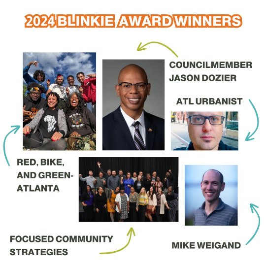
It's nice to be noticed, and it's very cool to be part of this great group of awardees. The awards are given out at their annual fundraising event on May 1st.
7 notes
·
View notes
Text

As I was reminded while walking here earlier today, the sidewalk on Edgewood Avenue is way too narrow. Folks regularly have to step into the roadway to pass others.
It shouldn't be like this anywhere, but especially not on the streetcar route. We're missing an opportunity to match transit investment with great pedestrian conditions.
Please look into redesigning this as a shared street, Atlanta! This is an incredible success story waiting to happen.
Some people complain that the streetcar "doesn't go anywhere people want to go," but I see the problem as being that we have 2.7 miles in the middle of the city that can be described by too many as a place they don't want to go.
What we should be asking is: how many people are we delivering to the streetcar by way of a combination of rail-supportive land use that puts an appropriate density near the stations -- and excellent pedestrian conditions that help alternatives to driving be competitive.
We're failing on all those fronts, but we can turn this ship around. We're capable of succeeding in Atlanta and becoming a city that truly supports alternatives to driving (like the streetcar) through our urban design and policies.
Every little piece of that puzzle matters, including the design of every block of street on the streetcar route.
16 notes
·
View notes
Text
The pedestrian/bike phase on the traffic light at Memorial Drive & Bill Kennedy Way is a wonderful thing to see, especially on a lovely & vibrant Saturday afternoon.
I stepped off the 107 bus and was able to immediately use the signal due to how long it lasts. Also my new camera has a feature for fixing wobbly movements and that's neat (I have neurological issues that affect my balance & I walk with a cane).
This is a state road, y'all. Never let it be said that improvements on a GDOT route are impossible. Good things can happen.
22 notes
·
View notes
Text
Better urbanism = more riders for MARTA = better maintenance and staffing for transit

Whenever you see problems on MARTA that are related to operations spending (maintenance or staffing or frequency of service) -- please think about an image like this one, where massive amounts of dead space or low-density developments surround our major investments in transit. In this case, Oakland City Station.
The two things are intrinsically connected.
A big portion of MARTA's annual operations budget comes from fare collections. More riders = more annual spending for MARTA's maintenance and staffing needs.
Unfortunately ridership stats for MARTA have not been impressive in recent years.
Folks, we have to build rail-supportive density around our transit stations, and we have to include progressively-low parking ratios (high parking ratios within developments are correlated with low transit ridership in cities), and design exceedingly walkable streets all around. Add in some public-funded deep affordability as well.
Unless we accomplish all of that near our transit stations, plus some stuff I've undoubtedly forgotten, we will not have a great system -- one with digital signs and various machines that are well maintained, and bus/rail lines that are well staffed.
And the more people fight against those needed improvements in density, parking reform, walkability, affordability, and more...the more we'll see a transit system that fails to be as well maintained as it could be.
11 notes
·
View notes
Text

Thinking about our visit to the pedestrian-scaled West Village in NYC a few weeks ago and wishing we hadn't sprawled our cities in a car-centric direction in the late 20th century. All steps toward undoing that damage are appreciated.
15 notes
·
View notes
Text
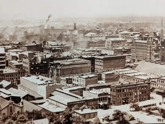

If you visit the Herndon Home museum in Vine City, check out the awesome 1890 photo of Downtown Atlanta in the lobby, pictured here. It appears to have been taken from the Capitol Building facing west/northwest.
For the second image, I used Google Earth to line up the view as it looks today, using the parking deck that now sits where the Kimball House was + the parking deck that now sits where Union Station was as guides. It's not pixel perfect but it's pretty darn close.
The overall built environment of 1890 is nicer in that it lacks the gruesome number of parking decks that the modern view has, and the streets are designed for walking.
But we're doing better now with pollution in this district. The smoke in the 1890 photo is awful. And even on that count we can do better -- seems like there's room for a lot more street trees in this section of Downtown.
(BTW one reason it's hard to line things up perfectly between these shots is that many of the streets in this part of Downtown are, today, viaducts that are raised up above the ground in order to put the roadways above the train tracks. In the 1890 photo the viaducts weren't yet built.)
4 notes
·
View notes
Text
Ten years after the Atlanta Civic Center closed, the property is still empty
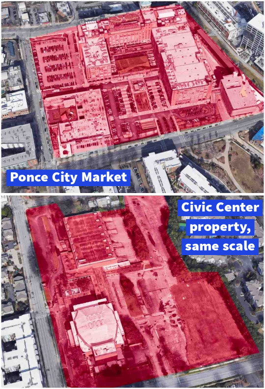
Top: Ponce City Market, for reference
Bottom: the Civic Center property, at the same scale
As of this year, the Civic Center has been closed for 10 years.
In 2017, three years after it shuttered, the Civic Center was sold by the city to the Atlanta Housing for $31 million with a promise of affordable housing to come. Two different development groups were selected over the years since then, but both pulled out of the project before producing anything.
A third development group is now trying to put something on this property.
According to an article in Urbanize Atlanta a couple of months ago, Atlanta Housing has secured low-income housing tax credits to partially cover the cost of redevelopment, while additional funding sources are being sought.
Quote from Urbanize Atlanta:
"The first facet of development calls for a building with 148 senior housing units that would rise on the northeast section of the Civic Center property, across the street from Renaissance Park. Consisting of all affordable, one-bedroom units with about 600 square feet each."
Hopefully the full financing will be found this year, and construction will start soon afterwards. This property is too large and too centrally located to sit empty for another 10 years.
Worth considering: can these large properties be divided and sold for development in pieces rather than waiting to 'land a whale', so to speak, that can handle a mega development? Could that prevent these long periods of total emptiness? Incremental development is how much of our best urban fabric was developed.
13 notes
·
View notes
Text
Pedestrian & transit conditions should shine where affordable homes are funded
Darin Givens | April 13, 2024
According to WSB news, Senator Jon Ossoff recently announced that $2 million in federal funds will create 20 new affordable housing units in Atlanta. In general, I think that's a really good use of public money.
But I do have concerns about the location...
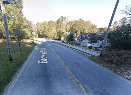
The homes will be inside the Browns Mill Village development in south Atlanta; pictured is the entrance to it on Browns Mill Road.
Per Google Maps, it takes 1.5 hrs to get from here to Midtown on MARTA, versus an 18 minute drive. Or it's a mile walk to the stop for the 78 bus to East Point (46 minutes total, or more if you don't walk fast), but only a 15 minute drive.
And as you can see, pedestrian conditions are awful.
I don't mean to dismiss this project. There are definitely good things about it. But at the same time, I want us to cast a critical eye on initiatives that fund new affordable homes in car-centric places with streets that are hostile pedestrians and that lack high frequency transit.
Meanwhile, the most walkable and bikeable places in the city have become less affordable. This is a toxic trend.
We have got to find a way to match these major investments in affordable housing with great access to alternative transportation, particularly with transit services that are often a lifeline for lower income residents. Maybe it's a case of ensuring that pedestrian and transit improvements are made in a place like this to coincide with the investment.
Whatever the fix is, we need to accept this as a problem and aim higher.
If this incident was a one-off, I wouldn't be so worked up. But this is a definite trend of failing to match affordable housing investments with great pedestrian infrastructure and high frequency transit. It needs to be called out and addressed.
13 notes
·
View notes
Text

Yep. We need someone to speak on the record about what's really happening with these announcements about four new infill MARTA stations and a new BRT line on North Avenue to the Bowen Homes redevelopment.
We went from the austerity of "we need to trim down the MARTA project list because we can't afford all this" & "the Campbellton Road project is now BRT because we can't afford rail" to the surprise of "we're massively expanding capital projects with new stations and BRT" in just a couple of years.
How? MARTA and the City of Atlanta owe us some real numbers, please. Otherwise the entire More MARTA tax and the recent austerity are really confusing.
Obviously, all of these recently-announced projects would be wonderful to have. I'm not arguing about that. I love 'em.
But Atlanta has a history of announcing things that don't happen (the massive redevelopment of Underground Atlanta that didn't materialize, for instance) or things that end up being surprisingly costly to the public (the Mercedes-Benz pedestrian bridge). It erodes the public trust.
I want transparency about this new situation so that we're better informed about decisions that are obviously being made behind closed doors that are affecting us all.
11 notes
·
View notes
Text
MARTA infill stations are announced
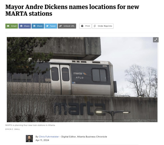
Big news from Atlanta Business Chronicle: Mayor Dickens says the locations for the four new MARTA infill stations are:
Krog Street-Hulsey Yard
Joseph E. Boone Boulevard
Murphy Crossing
Armour Yards
This is regarding the major announcement at the recent State of the City address, from Dickens, that four locations would be chosen for new infill stations.
Congratulations to snekposts on Twitter for correctly guessing where the infill stations would go. That's impressive.

Also, Dickens says a new Bus Rapid Transit line will connect the Bowen Homes redevelopment on Donald Lee Hollowell Parkway to Ponce City Market, likely on North Avenue (judging from previous proposals). Hopefully more details on that BRT line are coming soon.
And as exciting as all of this is, the story of where the money came from needs to be told at some point. It's strange that we had to go through a SPLOST process to raise money with a sales tax for transit; then the transit project list got whittled down because there wasn't enough money to fund everything; and now suddenly there's money for infill stations. It's curious.
16 notes
·
View notes
Text

I think it's safe to assume we aren't going to tear down any Georgia Tech buildings to increase road capacity on North Avenue.
Instead, we should be planning for reduced capacity for cars here -- and increased capacity for alternatives to driving. Maybe a light rail or BRT line. Or maybe better conditions for cycling. Or dedicated bus lanes. Or all the above.
Even the much ballyhoo'd Holy Grail of "synchronized traffic lights" won't accommodate this car traffic amid those street redesigns. We have to reduce car trips.
That means not only adding better conditions for alternatives to driving, but also ADDING MORE HOMES near those alternatives. With affordability & anti-displacement components included.
If anyone takes anything away from my 15 years of posting as ATL Urbanist (and as of this month it's exactly 15), please let it be this: adding new transit & bike lanes is important but it's not enough; we have to also make better use of the total built environment of the city by increasing the number of people who can live in proximity to great ped/bike/transit service here -- with an emphasis on lower income groups who are too often displaced to the suburbs and exurbs amid urban transformations.
19 notes
·
View notes
Text
Population growth & rail stations need better alignment in Atlanta
Darin Givens | April 10, 2024
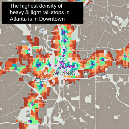
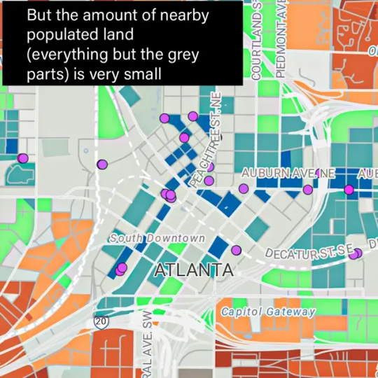
Check out the maps above. They clearly show that the highest density of light rail & heavy rail stops in Atlanta is in Downtown, but that only a small amount of land near those stops is populated by any level of residential development.
This is data that we likely already knew, but seeing it mapped out so clearly is impressive. And it should make us think about whether we're doing all we can to make the best use of our biggest investments in rail.
As we've found out the hard way over the last 30 years, building new rail lines or infill stations is incredibly expensive and doesn't happen quickly (the last rail line MARTA built was the one to North Point Station which opened in 2000).
We shouldn't stop planning for expansion of rail, such as the line promised for the Beltline, but making the best use of land near our existing rail service is at least as crucial as expansion.
Our track record is grim. Many parking lots and empty buildings sit within a couple of blocks of the Atlanta Streetcar tracks. And this, below, is the blighted area surrounding Garnett MARTA Station in Downtown.
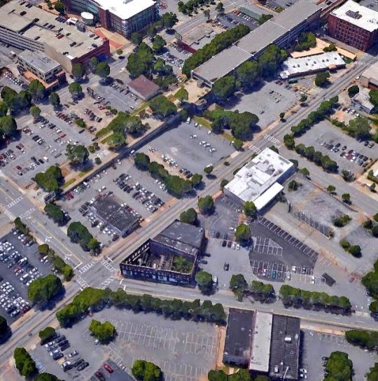
Matching development -- with a big dose of residential density -- with our rail stations is common sense, Urbanism 101 stuff. It shouldn't be as hard as we've made it out to be in Atlanta. We can and must do better.
These maps at the top of this post were made with an impressive mapping tool, Close.city at www.close.city
The tool was built by Henry Spatial Analysis in Seattle. It lets you create walkability maps of various data points such as supermarkets, libraries, transit stops, and more.
10 notes
·
View notes
Text

Pershing Point Park in Midtown, seen this evening while on a walk. I always enjoy passing by this lovely space.
John Ruch wrote about the park last year in a Saporta Report article, 'City Council approves landmarking of Midtown’s World War I memorial'.
From that article:
"A group of residents bought the land in 1918 and gave it to the City on the condition that it remain open space. Originally named Goldsboro Park, the space was renamed later in 1918 for Gen. John J. Pershing, the famed commander of the American Expeditionary Forces in the war. Shortly thereafter, the City approved a plan by a group of “War Mothers” to raise funds and erect a memorial in the park to locals killed in WWI, which was dedicated in 1920."
17 notes
·
View notes
Text
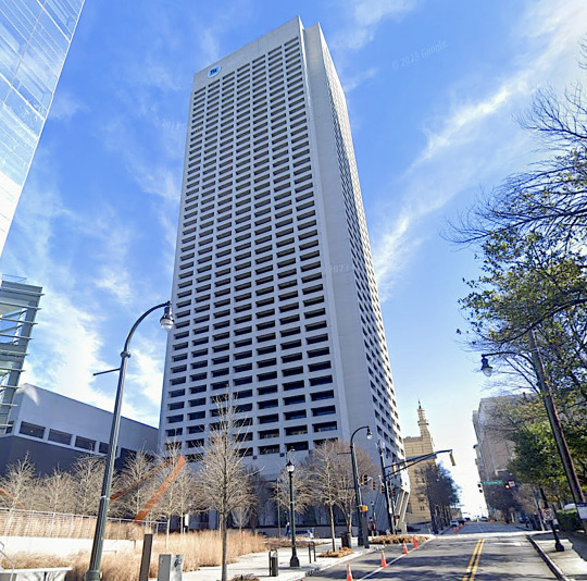
In his latest report on office occupancy in Midtown Atlanta, commercial real estate pro Tim Wright says that Tower Square on Peachtree Street is basically empty now.
That's astounding.
The project that very nearly demolished the Fox Theater in 1974, due to the preferred placement for its parking deck, is now a 47-story dud --essentially, an accidental sculpture.
It might be funny if it wasn't for all the wasted space this tower represents, sitting next to a MARTA rail station. There's nothing amusing about wasting our precious investments in heavy rail. Access points to these rail lines should be providing excellent urbanism and density, not hollow towers.
10 notes
·
View notes
Text
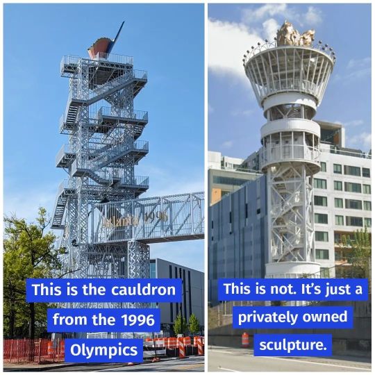
Atlanta's 1996 Olympics cauldron stands south of the Capitol Building on Capitol Avenue. It was designed by Siavash Armajani, an Iranian-born American sculptor.
The torch sculpture in Midtown was privately commissioned by Taz Anderson to celebrate the games (it was originally an observation deck but it was shut down).
Just wanted everyone to be on the same page about this. Sometimes I'll see comments from folks thinking that Midtown sculpture is the 96 cauldron.
16 notes
·
View notes