
Statistics
We looked inside some of the posts by delftholland-blog and here's what we found interesting.
Average Info
Notes Per Post
18
Likes Per Post
7
Reblog Per Post
11
Reply Per Post
0
Time Between Posts
5 months
Number of Posts By Type
Photo
17
Last Seen Tumblr Blogs


Fun Fact
There were a total of 171.5 billion posts on Tumblr in 2019.
Photo
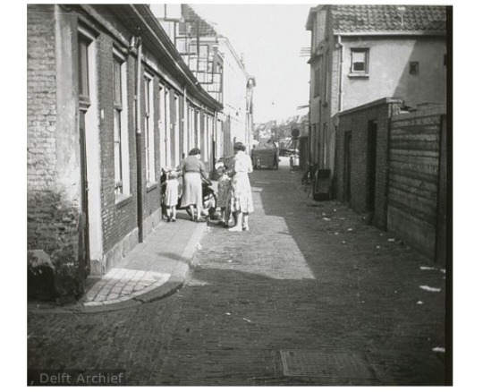
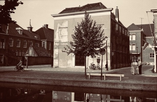
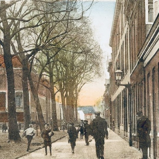
CELLEBROERSTRAAT DELFT HOLLAND 1955
The Cell Broerstraat seen to the north. In the area bounded by the Verwersdijk, Choorstraat, Front Street and Three Akersstraat was in the Middle Ages established the convent of the Alexian Brothers or cell. The brothers of this order mainly put to the care of the sick. The convent chapel was a late Verwersdijk off and was only accessible through the alley named after them. In the construction of a parking lot at the former church grounds of St. Hippolytus in August 1983 emerged the foundation of this monastery. Before the foundation of the monastery of the cell brothers named this street Krepel Strate (reported in 1379 [Br. 13]) or Crepelsteghe (1400, [Br. 2]). Both the old and new name they used the additives 'rose' and 'street' interchangeably.
De Cellebroerstraat naar het noorden gezien. In het gebied begrensd door de Verwersdijk, Choorstraat, Voorstraat en Drie Akersstraat was in de Middeleeuwen het klooster van de Alexianen of cellebroeders gevestigd. De broeders van deze orde legden zich vooral toe op de verpleging van zieken. De kloosterkapel lag een eind van de Verwersdijk af en was alleen bereikbaar door de naar hen genoemde steeg. Bij de aanleg van een parkeerplaats op het voormalige kerkterrein van de Sint-Hippolytuskerk in augustus 1983 kwam de fundering van dit klooster te voorschijn. Vóór de stichting van het klooster van de cellebroeders heette deze straat Krepelstrate (vermeld in 1379 [Br. 13]) of Crepelsteghe (1400, [Br. 2]). Zowel bij de oude als nieuwe naam gebruikte men de toevoegingen ‘steeg’ en ‘straat’ door elkaar.
via https://dayone.me/2cVgz1a
#Verwersdijk#Voorstraat#Klooster#Cellebroeders#Cellebroerstraat#Kloosterkapel#Delft#Holland#1955#Choorstraat
0 notes
Photo
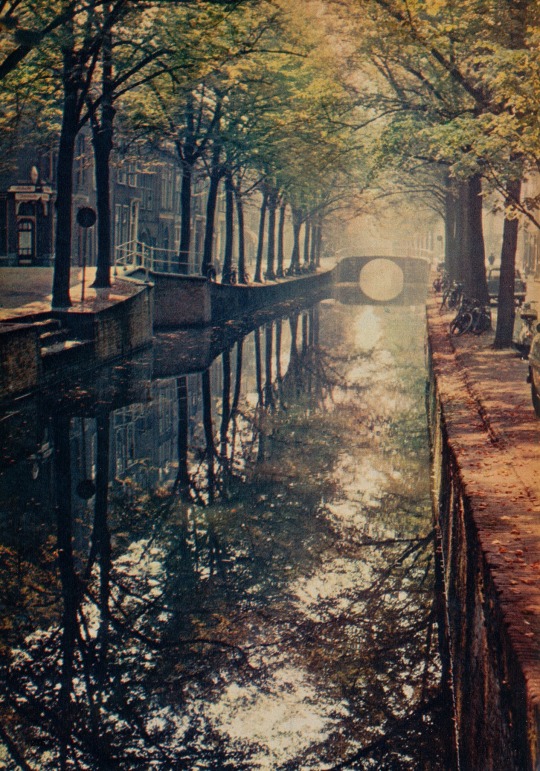
OUDE DELFT, 1961 beschrijving: De gracht die de stad haar naam heeft gegeven, kreeg zijn huidige verloop aan het eind van de 12de eeuw. De voorloper was een veel bochtiger waterloop van mogelijk natuurlijke oorsprong, maar gezien de naam gedeeltelijk gegraven of gekanaliseerd. ‘Delf’ is afgeleid van ‘delven’ en heeft dezelfde betekenis als ‘gracht’, dat van ‘graven’ is afgeleid. In Delftse akten uit de Middeleeuwen werden vele grachten ‘delf’ genoemd. De oudste vermelding van de ‘Delf’ is in een akte waarin graaf Floris en zijn vrouw aan de abdij van Egmond een schenking doen. Er is daarin sprake van ‘iuxta Delf X mansus, ex altera parte Delf VIII 1/2 mansus’, een schenking dus van 10 hoeven aan de ene kant van (de) Delf en 9½ hoeven aan de andere kant. Dit stuk draagt als jaartal 1083, maar dateert in werkelijkheid van 1125-1150. Een honderdtal meters ten oosten van de Delf is een nieuwe gracht gegraven, die de naam Nieuwe Delft kreeg. De eerste Delf heette voor het eerst Oude Dilf in de akte van 1268, waarin het stadsrecht werd uitgebreid (Dilf is hetzelfde als Delf). In de 14de en 15de eeuw kwam vaak een verkorte vorm Oudelf voor [Br. 1]. De ‘t’ aan het eind is – evenals in de naam van de stad – een 16de-eeuwse toevoeging. Hoewel de ‘t’ thans algemeen geaccepteerd is, is dat niet het geval voor het bijbehorende lidwoord. Mevrouw M.A. Lindenburg schreef daarover aan de Delftsche Courant (2 september 1997): ‘Een lichte irritatie bevangt me altijd als ik in de Delftse pers ‘de’ Oude Delft tegenkom. Al eeuwenlang zegt de Delftse bevolking ‘het’ Oude Delft. Waarom moet nu opeens in gedrukte vorm ‘de’ verschijnen? Wie heeft dat verzonnen? Ik weet het werkelijk niet, ik zeg dus maar meneer X. Boitet in zijn Beschrijving der Stadt Delft, uit 1729, schrijft consequent ‘het’ Oude Delft [hij is daarmee de eerste, PvdK]. Latere schrijvers, bijvoorbeeld de letterkundige Dirk Coster en Anne Berendsen in haar mooie boekje uit 1957 zeggen en schrijven gewoon ‘het’. Meneer X was er toen nog niet om hen op de vingers te tikken. Ze zouden zich waarschijnlijk ook niet een hem gestoord hebben. Wie er zich ook niet aan stoort is Wim Weve, in zijn recente boek Monumenten in Delft. Hij durft gewoon ‘het’ Oude Delft te schrijven. Hoe komt meneer X zo gek om met alle geweld de Delvenaars ‘de’ Oude Delft door de strot te drukken? Ik kan me een reden indenken. Meneer X komt uit Middelburg. Daar hebben ze ook een straat die Delft heet, de Lange Delft. Maar daar zeggen ze wel ‘de’. Het Lange Delft zou hen als een vloek in de oren klinken. Maar in Delft is dat anders’. Desondanks houden we het in dit boek op 'de' Oude Delft. De Oude Delft kent zeer weinig doodlopende sloppen. Slechts één is er, die onder een naam bekend staat, namelijk de Sint-Hieronymuspoort. Volgens de Kaart Figuratief is dat de poort tussen nummers 159 en 161. Deze poort had een gevelsteen die op enkele schilderijen van Pieter de Hoogh voorkomt en die thans in het huis nr. 159 is ingemetseld. De tekst op deze steen begint met ‘Dit is in Sint Hieronimus Daelle’. De poort was oorspronkelijk de toegang tot het Sint-Hieronymusklooster. Over de Oude Delft liggen tien bruggen, van noord naar zuid Roosbrug, Bagijnhofbrug, Harmen Schinckelbrug, Bartholomeusbrug, Heilige Geestbrug, Jeronymusbrug, Mauriciusbrug, Nieuwe Sint-Jansbrug (tijdelijk), Sint-Jansbrug, Weesbrug en Kapelsbrug. (Krogt, P.C.J. van der, Straatnamen van Delft: Verklaring van de namen van straten en buurten, grachten en bruggen, 2000) https://www.beeldengeluid.nl/en/media/5860/de-oude-delft
via https://dayone.me/2bkbzta
4 notes
·
View notes
Photo
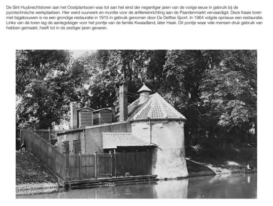
The Sint Huybrechtstoren on the Oostplantsoen was in use at the pyrotechnical workshops until the end of the nineties of the last century. Here fireworks and ammunition for the artillery equipment at the Paardenmarkt were manufactured. This beautiful tower with outbuildings was put into use by De Delftse Sport after a thorough restoration in 1915. In 1964 another restoration followed. To the left of the tower was the landing stage for the ferry of the Kwaadland family, later Haak. This ferry, which many people used to use, sailed until the sixties.
1 note
·
View note
Photo
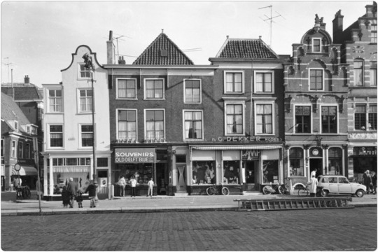
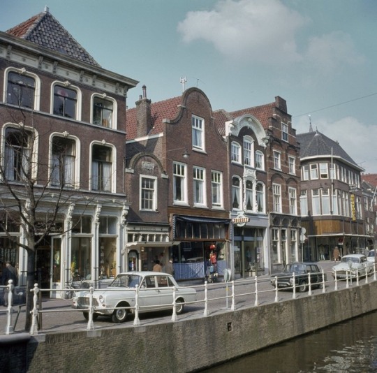
Drugstore De Salamander at Markt 47, lingerie shop Dekker at Markt 49 and a shop in Delft blue ware from owner Frits Creemers at Markt 53.
1 note
·
View note
Photo
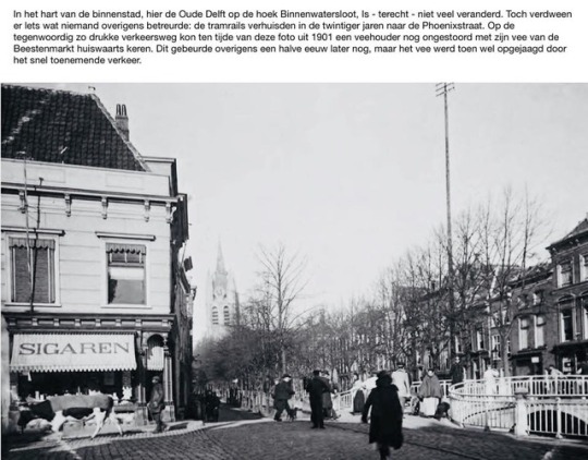
In the heart of the city center, here the Oude Delft on the corner of Binnenwatersloot, - rightly - not much has changed. Nevertheless, there was something that no one regretted: the tram rails moved to the Phoenixstraat in the twenties. On the now so busy traffic road at the time of this photo from 1901 a farmer could go home with his cattle from the Beestenmarkt undisturbed. This happened incidentally half a century later, but the cattle were then rushed by the rapidly increasing traffic.
1 note
·
View note
Photo
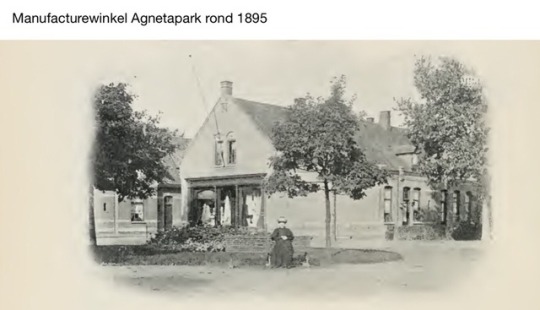
Manufacturing store Agnetapark around 1895
0 notes
Photo
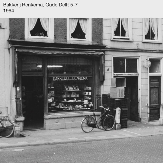
Bakery Renkema, Oude Delft 5-7 1964 (bij Delft)
1 note
·
View note
Photo
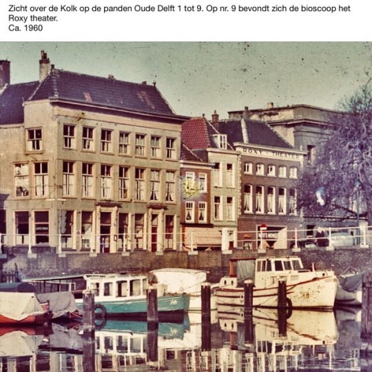
View over the ZuidKolk on the buildings Oude Delft 1 to 9. At no. 9 was the cinema the Roxy theater.
0 notes
Photo
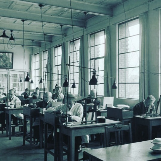
OOSTEINDE, PORCELEYNE FLES Earthenware factory 'De Porceleyne Fles’ Oosteinde 1940 People working in the painting room.
5 notes
·
View notes
Photo
SINT MAGDALENAKLOOSTER Initially, there was a convent of the St. Mary Magdalene convent here. In the period 1557/1558 a plague epidemic broke out that kept a terrible house. During this serious plague epidemic, the goods were handed over to the Oude Gasthuis, which used the buildings as a pest house. Permission was given for this transfer by the prior of Sion. It was thoroughly renovated in 1656 and furnished as a shelter for the surgeons' guild. On the ground floor one came through a porch in the large room where the guild meetings took place and the pupil also took his exam to obtain the degree of master surgeon. There was also a room for the library and a kitchen. Until 1959, the chapel of the St. Mary Magdalene Monastery was still standing, after demolishing this led to a complete square that was soon called the Doelenplein in the vernacular. It was not until 1995 that this name became official.
0 notes
Photo
WIJNHAVEN The 13th-century registers of the French wine buyers mention various affiliates of wine to Delft. The import of French wine is also often mentioned in the archives of the Court of Audit of the Henegouwse Huis from the 14th century. It is possible that the Wijnhaven - first Wijnstraat - was the relocation of this wine. The oldest entry can be found in a deed dated 1543 about the house De Zwan on the Wijnstraat. At the time, this name might just be in vogue, because in 1538 the same plot was still called 'a burned farmyard on the Voirstraat near the Bucxbregge'. Until the 16th century the Wijnhaven appeared as a part of the Voorstraat (see there and Nieuwe Delft), sometimes also as part of the Hoogstraat (see Hippolytusbuurt). Around 1700 the name changed itself from Wijnstraat to Wijnhaven, while in 1707 also Wijnkade was mentioned. The Waagbrug and the Touwbrug are located across the Nieuwe Delft in the Wijnhaven.
5 notes
·
View notes
Photo
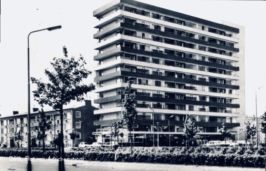
VAN ADRICHEMSTRAAT - Van Adrichem, family to which several burgomasters of Delft belonged in the 16th and 17th centuries, namely Adriaen Claesz. van Adrichem, choir buyer in 't Dubbele Cruys (mayor in 1550, 1552 and 1553), Claes Adriaensz. van Adrichem (between 1585 and 1606), Jacob Adriaensz. van Adrichem (1613-1617) and Joost Jacobsz. van Adrichem (between 1628 and 1644). The western flat on the Van Adrichemstraat is called Kerstanje, the other flat does not have its own name.
0 notes
Photo
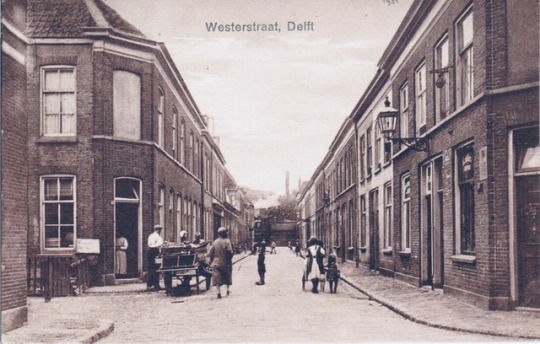
WESTERSTRAAT - On 28 January 1879 the city council approved the plan for 'the construction of new neighborhoods in the southwestern part of the municipality of Delft'. This neighborhood formed the first Delft expansion outside the city and was designated with the logical name Westerkwartier. In this rural area directly south of the Buitenwatersloot, several old names were known, namely the Coenderstraat, the Geldelozenpad, the Moordenaarslaan and the Lakenraamslaan. With the exception of the Coenderstraat, these names were not considered suitable for streets in a residential area. One of the first streets this district was built on the place of the Geldelozenpad, which was renamed and was called Westerstraat. A cross street was named Westerdwarsstraat without much imagination (November 11, 1879). The district was expanded; a street running north of the Westerstraat was named 2e Westerstraat, a new cross street between the Coenderstraat and Westerdwarsstraat became the 2nd Westerdwarsstraat (2 February 1886). Construction continued and in 1889 Westerstraten and cross streets had to be appointed again. In order to make the names more systematic, the Westerstraten of the Buitenwatersloot were decided to go south and the Westerdwarsstraten from the city in a westerly direction. As a result, the Westerstraat became 2e Westerstraat and the 2nd Westerstraat became the 1st. Both cross streets were also renumbered, and a 3rd and a 4th Westerdwarsstraat were added (11 October 1889). In the following years, a third Westerstraat and a 5th Westerdwarsstraat came without a council decision. The situation was now particularly complicated with three Westerstraten and five Westerdwarsstraten. In 1896, each street was decided to give its own name, for which names were chosen from Delft history.
0 notes
Photo
WATERINGSEVEST - You had a rampart (a vest) and you had a gate. And when you walked through the gate you came on the road to Wateringen. So it was called the Wateringseweg and the gate, indeed, the Wateringsepoort. And the road, that was logically the Wateringsevest. Do not think about it too long: the road to, the gate, and ready. That was how it often used to be; we wrote about it before. That gate was at the head of the Noordeinde, with ramparts on the left and right. The walls were originally different: once there was a sharp bend in the road towards Phoenixstraat. In that perpendicular curve was the Kampveld, a terrain roughly at this location where in the Middle Ages tournaments were fought. Kletterende swords and stuff. Later there was also a bridge over the city singel with the name Kampvelt bridge. The Kampveldweg is now the small piece of road under the railway viaduct. The Kampveld is still there: just through the bend, the first side street of the Phoenixstraat. The rampart was excavated at the site at the end of the nineteenth century and a little later, in 1928, the sharp bend was removed for the purpose of tram line 1. Not only the tram but also for the automobile there was a lot of digging in the course of the years. , asphalted and various traffic lights were put down. In 1980, the part up to the Reinevelt bridge was also taken at the Wateringsevest. Via the Nieuwe Plantage and the Lepelbrug you will reach the aforementioned Wateringseweg along Calve, including the Koolhaven Bridge, in Delft better known as the 'oil bridge'. Once it was a direct connection with Wateringen; now you first arrive in Rijswijk on the Lange Kleiweg and you have to turn left on Churchillaan and finally arrive in the gardeners' village.
0 notes
Photo
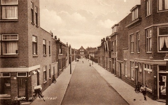
WILLEMSTRAAT DELFT HOLLAND According to Kramer, the street is named after the son of Dirk Bontenbal, the builder of the first houses there. The street must then be named after Johan Wilhelm Christiaan Bontenbal (Hof van Delft 1884-The Hague 1931), whose call sign was apparently Willem. Like his father, he was a carpenter and lived in The Hague since 1906. Given that one of the side streets was called Emmastraat (now part of the Laan van Overvest) to Queen Emma, a mention to King William III would also be possible.
0 notes
Photo
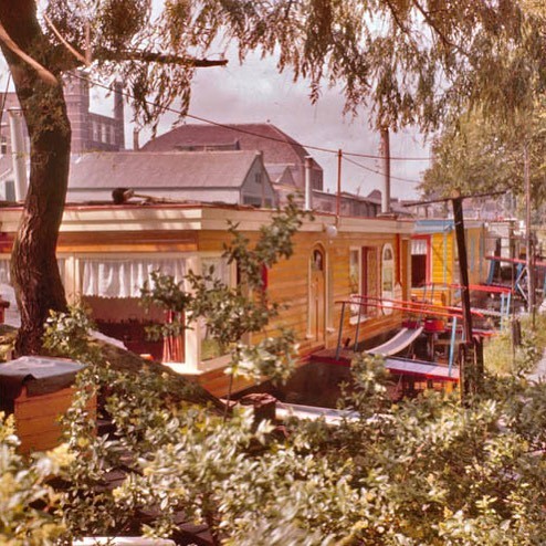
Houseboats on the Zuidergracht - Zuiderstraat in Delft (ca.1978)
0 notes
Photo
ZUIDERSTRAAT 1926 Until the nineteenth century this street was called Bastiaansvest and was named after Sint Sebasitaan; the patron saint of the archers' guild. The nearby watchtower was called the Bastiaanstoren and was about the place where nowadays the Sint Sebastiaansbrug is located. In 2002, remains of this waltower were uncovered during archaeological research. From about 1620 to about 1720 the eastern part of the Bastiaansvest was called Malle Gijsjesvest in the vernacular and was named after Malle Gijsje who lived there.
0 notes