
Geospatial videos, news, articles and events relating to GIS, cartography, Remote Sensing, GPS, Surveying, Geomatics and geospatial technologies
Don't wanna be here? Send us removal request.
Statistics
We looked inside some of the posts by monde-geospatial and here's what we found interesting.
Average Info
Notes Per Post
21
Likes Per Post
21
Reblog Per Post
0
Reply Per Post
0
Time Between Posts
6 hours
Number of Posts By Type
Text
17
Last Seen Tumblr Blogs


Fun Fact
Tumblr was attacked by a cross-site scripting worm deployed by the Internet troll group GNAA on Dec 3, 2012.
Text
Role of Geospatial Technologies in Cross-sectoral Stakeholder Coordination for Gati Shakti
Role of Geospatial Technologies in Cross-sectoral Stakeholder Coordination for Gati Shakti
Role of Geospatial Technologies in Cross-sectoral Stakeholder Coordination for Gati Shakti The GeoSmart Infrastructure 2022 conference brings together leaders from across India to share digital use-cases that design, build, and maintain world-class transport infrastructure assets in order to meet for the nation’s future demands. India’s transportation infrastructure has witnessed significant…

View On WordPress
10 notes
·
View notes
Text
Top New Features in Global Mapper Pro v24.0
Top New Features in Global Mapper Pro v24.0
Top New Features in Global Mapper Pro v24.0 Global Mapper v24 Pro is available now. The release features exciting new integration between Global Mapper Pro and the iOS and Android Global Mapper Mobile app with the expanded Mobile Data Management tool, which now includes data review and merging from multiple map files. With user experience in mind, a new Script Builder tool in Global Mapper Pro…
View On WordPress
6 notes
·
View notes
Text
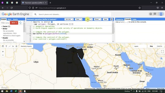
Buffer and Centroid analysis in Google Earth Engine - Geometric Operation
Buffer and Centroid analysis in Google Earth Engine – Geometric Operation
Buffer and Centroid analysis in Google Earth Engine – Geometric Operation In video tutorial you will learn to create Buffer and learn Centroid analysis in Google Earth Engine.
View On WordPress
5 notes
·
View notes
Text
Top New Features in Global Mapper version 24
Top New Features in Global Mapper version 24
Top New Features in Global Mapper version 24 Version 24 of #GlobalMapper comes with enhanced raster, 3D data display, and many other updates. Learn more in this blog. https://ift.tt/l8zqFxL

View On WordPress
0 notes
Text
qgis automation
qgis automation In this video, I will take a closer look at how to automate processes in QGIS using python and demonstrate many tricks to make automating with python in QGIS much easier than you think. Link to the python script https://ift.tt/0SNipWl Chapters 0:00 Automating QGIS using Python 1:00 Four methods of automation 1:20 The visual model builder 2:13 The batch processing 2:40 Python…

View On WordPress
0 notes
Text
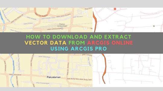
How To Download Geospatial Data from ArcGIS Online using ArcGIS Pro. Works for more 2000 features
How To Download Geospatial Data from ArcGIS Online using ArcGIS Pro. Works for more 2000 features
How To Download Geospatial Data from ArcGIS Online using ArcGIS Pro. Works for more 2000 features How to download and extract vector geospatial data hosted in ArcGIS Online or ArcGIS Enterprise using ArcGIS Pro in very easy, fast and simple. Music: bensound.com #arcgispro #downloaddata #arcgisonline
View On WordPress
0 notes
Text
Fix data when it appears in the wrong place
Fix data when it appears in the wrong place
Fix data when it appears in the wrong place In this tutorial, learn how to use the Define Projection tool in ArcGIS Pro to replace missing coordinate system information. To follow along, download the data [https://ift.tt/UCmB1XY], or read the text version of this lesson [https://ift.tt/R7m6TtG] at Learn ArcGIS. The data [https://ift.tt/dtWywA7] used in this video is from the Environment Agency of…
View On WordPress
0 notes
Text
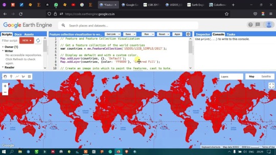
Import World boundary and Change its Symbology in Google Earth Engine
Import World boundary and Change its Symbology in Google Earth Engine
Import World boundary and Change its Symbology in Google Earth Engine In this video tutorial I had shown how to add world county level boundary (feature) and change its symbology in Google Earth Engine.
View On WordPress
0 notes
Text
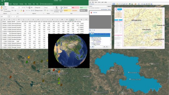
how to add excel sheet, Shapefile and GeoTIFF file on google earth pro
how to add excel sheet, Shapefile and GeoTIFF file on google earth pro
how to add excel sheet, Shapefile and GeoTIFF file on google earth pro how to add excel sheet, Shapefile and GeoTIFF file on google earth pro Join our telegram Group Remote Sensing & GIS Professionals:- https://ift.tt/LAbIXnF Any Help Contact Mr.Vikas Ghadamode–[email protected] WhatsApp Number= +918421031398 Tags, how to add excel sheet, Shapefile and GeoTIFF file on google earth pro,…
View On WordPress
0 notes
Text
Merge multiple layers into one
Merge multiple layers into one
Merge multiple layers into one In this tutorial, learn how to use the merge tool in ArcGIS Pro to combine layers and how to configure a field map to resolve mismatched fields. To follow along, download the project package [https://ift.tt/3zHLdCI], or read the text version [https://ift.tt/TR7iSEk] of this lesson at Learn ArcGIS. The data used in this video is from Natural Earth…

View On WordPress
0 notes
Text
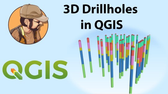
Display drillholes in 3D in Qgis and Create Sections
Display drillholes in 3D in Qgis and Create Sections
Display drillholes in 3D in Qgis and Create Sections In this video i’ll show you how to display drillholes in 3D with geology or assay data in Qgis and create cross sections automatically. if you want to learn more about Qgis and master this free GIS tool check out my course here : https://ift.tt/TFEZY76 ✅🔥🔥🔥Get All my courses for a Flat Price here 🔥🔥🔥 : https://bit.ly/geologybundle ✅Get my…
View On WordPress
0 notes
Text
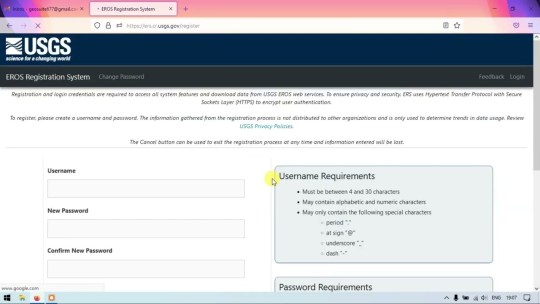
Download Landsat 4-5 TM Data from EarthExplorer | Landsat Data Access
Download Landsat 4-5 TM Data from EarthExplorer | Landsat Data Access
Download Landsat 4-5 TM Data from EarthExplorer | Landsat Data Access This tutorial will help you to download Landsat 4 & 5 TM (Thematic Mapper) satellite images from USGS EarthExplorer. Landsat 4-5 offers 30m resolution images with 7 bands from 1982-2012. Check the important links below: How to Create Account in EarthExplorer (USGS): Details of Landsat 4-5 TM: https://ift.tt/O9aqJWy Bands and…
View On WordPress
0 notes
Text
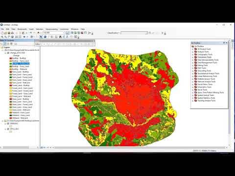
Post classification comparison Change detection using ArcMap 10.8.1
Post classification comparison Change detection using ArcMap 10.8.1
Post classification comparison Change detection using ArcMap 10.8.1 In this video, I have tried to show how to detect a change ” From and To” using the ArcMap Geoprossesing Intersect tool. and one thing you have to know about this method of change detection is the accuracy of the change detection is affected by the accuracy of the classified before and after image
View On WordPress
0 notes
Text
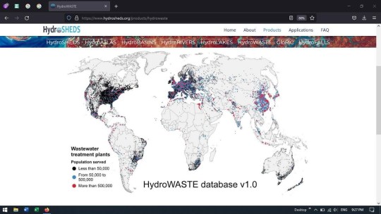
Download Locations of Wastewater Treatment plants using HydroSHEDS | Shapefile | Global Level
Download Locations of Wastewater Treatment plants using HydroSHEDS | Shapefile | Global Level
Download Locations of Wastewater Treatment plants using HydroSHEDS | Shapefile | Global Level In this video I had shown how to download the Locations of Wastewater Treatment plants using Hydrosheds. The location file can be download as csv and i had demonstrated how to convert the csv to shapefile. The data is available at global level. Official page of…
View On WordPress
0 notes
Text
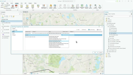
ArcGIS Pro - Manage Topology (settings/config/Dirty Areas)
ArcGIS Pro – Manage Topology (settings/config/Dirty Areas)
ArcGIS Pro – Manage Topology (settings/config/Dirty Areas) Video #152 In this video I just talk about the various options available to you when using the ‘Manage’ option. I discuss: – Adding/Removing feature classes from the existing Topology rules – Adding/Removing/Editing existing rules – Saving/Loading rules – Using Dirty Areas layer to show areas not yet validated (after an edit)
View On WordPress
0 notes
Text
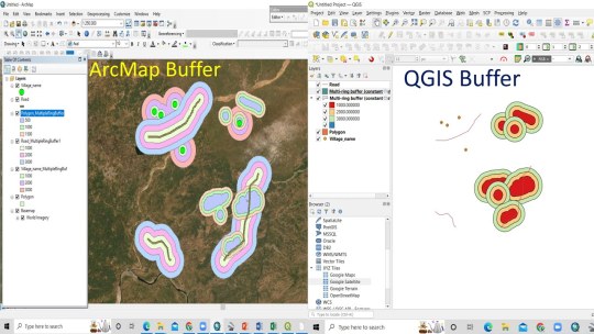
RS & GIS QA2: How to Create Multi Ring buffer Analysis using ArcGIS and QGIS
RS & GIS QA2: How to Create Multi Ring buffer Analysis using ArcGIS and QGIS
RS & GIS QA2: How to Create Multi Ring buffer Analysis using ArcGIS and QGIS Multi ring buffer Analysis using ArcGIS and QGIS Join our telegram Group Remote Sensing & GIS Professionals:- https://ift.tt/LAbIXnF You May Like Google earth Playlist : https://youtube.com/playlist?list=PLJh13Fo10QOvwBvLBdEiFgb25M8HTQl6N ArcGIS : https://youtube.com/playlist?list=PLJh13Fo10QOuiP3yG26SD056_WVgxUTAg QGIS:…
View On WordPress
0 notes
Text
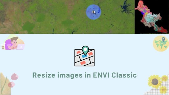
Resize (Clip) Images in ENVI Classic
Resize (Clip) Images in ENVI Classic
Resize (Clip) Images in ENVI Classic How to resize/clip satellite images in ENVI Classic (Please turn on the subtitles for detailed instructions) Timestamps: 0:00 Intro 0:10 Basic clip 1:47 Clip image according to the shapefile boundary Facebook: https://ift.tt/RxkXVJ3 (English) https://ift.tt/DGvZQPb (Vietnamese) Blog: https://ift.tt/FqLXp3I Website: https://opengis.vn/ #ENVI #ENVIClassic…
View On WordPress
0 notes