
A micro-blog of random electronics and ham radio things.
Don't wanna be here? Send us removal request.
Statistics
We looked inside some of the posts by radiogeek and here's what we found interesting.
Average Info
Notes Per Post
856
Likes Per Post
658
Reblog Per Post
194
Reply Per Post
2
Time Between Posts
2 months
Number of Posts By Type
Text
15
Quote
2
Last Seen Tumblr Blogs


Fun Fact
In 2020, 27% of US Tumblr users had an annual household income of over $100,000.
Text
There’s no award for 100 successful #pota activations, or is there?

0 notes

Text
Happy new year from Osage County State Fishing Lake (US-7409) in #Kansas, where it was a balmy 42°F. Band conditions seemed rough, but old man winter is about to get serious and I thought I’d better take a shot. #hamradio #pota

0 notes
Text
The scene today at Lyon County State Fishing Lake (US-7403). #hamradio #pota

0 notes
Text
When #Kansas gives you 63°F in December, the obvious choice is to head down to Woodson County State Fishing Lake to say hello to 79 of your best friends. #hamradio #pota #weekendwarrior

0 notes
Text
My view this evening at Cross Timbers State Park (US-2334) after finishing up my first-ever #hamradio 5-park #pota rove, which also included Montgomery State Fishing Lake (US-7407), Elk City State Park (US-2337), Wilson State Fishing Lake (US-7410), and Fall River State Park (US-2338). Three of those parks were also new to me as an activator.

0 notes
Text
Earlier today: #hamradio #pota at Elk City State Park (US-2337).

0 notes
Text
Earlier today: #hamradio #pota at Elk City State Park (US-2337).
0 notes
Text
#Fall #4Runner #pota #camping at Osage State Fishing Lake (US-7409).

0 notes
Text
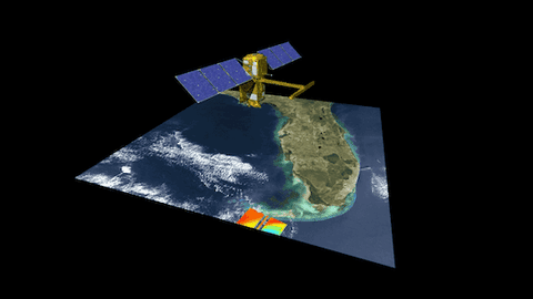
5 Ways Studying Water Will Help Us Better Understand Earth
Studying our home planet is just as powerful as exploring what’s beyond it.
Surface Water and Ocean Topography (SWOT) is a joint mission developed by NASA and the French space agency Centre National d’Études Spatiales (CNES), with contributions from the Canadian Space Agency and the UK Space Agency. It will track water on more than 90% of Earth’s surface and help communities, scientists, and researchers better understand this finite and vital resource. And it’s launching this month!
So how will SWOT help us better understand Earth? Here are 5 ways.

SWOT will address some of the most pressing climate change questions of our time.
An important part of predicting our future climate is determining at what point Earth’s ocean water slows down its absorption of the excess heat in the atmosphere and starts releasing that heat back into the air, where it could accelerate global warming. SWOT will provide crucial information about this global heat exchange between the ocean and the atmosphere, enabling researchers to test and improve future climate forecasts.
The satellite will also offer insights to improve computer models for sea level rise projections and coastal flood forecasting.
Data from SWOT will additionally help scientists, engineers, water managers, and others better monitor drought conditions in lakes and reservoirs and improve flood forecasts for rivers.

SWOT is the first satellite mission that will observe nearly all water on the planet’s surface.
SWOT will measure the height of water in Earth’s lakes, rivers, reservoirs, and the ocean, giving scientists the ability to track the movement of water around the world.
SWOT’s eye in the sky will provide a truly global view of the water on more than 90% of Earth’s surface, enriching humankind’s understanding of how the ocean reacts to and influences climate change along with what potential hazards – including floods – lie ahead in different regions of the world.

SWOT will see Earth’s water in higher definition than ever before.
Because everything is better in HD 😉, SWOT will view Earth’s ocean and freshwater bodies with unprecedented clarity compared to other satellites, much like a high-definition television delivers a picture far more detailed than older models. This means that SWOT will be able to “see” ocean features – like fronts and eddies – that are too small for current space-based instruments to detect. Those measurements will help improve researchers’ understanding of the ocean’s role in climate change.
Not only will the satellite show where – and how fast – sea level is rising, it will also reveal how coastlines around the world are changing. It will provide similar high-definition clarity for Earth’s lakes, rivers, and reservoirs, many of which remain a mystery to researchers, who aren’t able to outfit every water body with monitoring instruments.
SWOT data will be used to help make decisions about our daily lives and livelihoods.
As climate change accelerates the water cycle, more communities around the world will be inundated with water while others won’t have enough. SWOT data will be used to monitor drought conditions and improve flood forecasts, providing essential information to water management agencies, disaster preparedness agencies, universities, civil engineers, and others who need to track water in their local areas. SWOT data also will help industries, like shipping, by providing measurements of water levels along rivers, as well as ocean conditions, including tides, currents, and storm surges.

Finally … SWOT will pave the way for future Earth missions.
With its innovative technology and commitment to engaging a diverse community of people who plan to use data from the mission, SWOT is blazing a trail for future Earth-observing missions. SWOT’s data and the tools to support researchers in analyzing the information will be free and accessible. This will help to foster research and applications activities by a wide range of users, including scientists, resource managers, and others who in the past may not have had the opportunity to access this kind of information. Lessons learned from SWOT will lead to new questions and improvements for future missions, including our upcoming Earth System Observatory, a constellation of missions focused on studying key aspects of our home planet.

Keep track of the mission here. And make sure to follow us on Tumblr for your regular dose of space!
853 notes
·
View notes
Text
1 note
·
View note
Quote
Tumblr is this weird thing that fills a role on the internet that nothing else does.
How to buy a social network, with Tumblr CEO Matt Mullenweg - The Verge
1 note
·
View note
Quote
alternatives
Twitter chaos too much? Try alternatives such as Mastodon, Clubhouse or Tumblr - The Economic Times
0 notes
Text
0 notes
Text
Members of the Hill Country Amateur Radio Club in Texas joined the Kerr Area Rural Fire Association for an exercise Nov. 12 to test their communications capabilities.
0 notes