#ahmed muhiddin piri
Text
Selected maps from Ahmed Muhiddin Piri, taken from the book Kitāb-ı Baḥrīye, first published in 1521 and revised a few years later as a gift for Sulemain I. Ahmed Muhiddin Piri, born in 1465, was an Ottoman geographer, cartographer and privateer who served in many Ottoman naval battles, including the Conquest of Egypt and the Siege of Rhodes. In 1553, he was "imprisoned and unjustly condemned to death for failure to perform his duty by the governor of Egypt Mehmed Pasa[...]" [source]
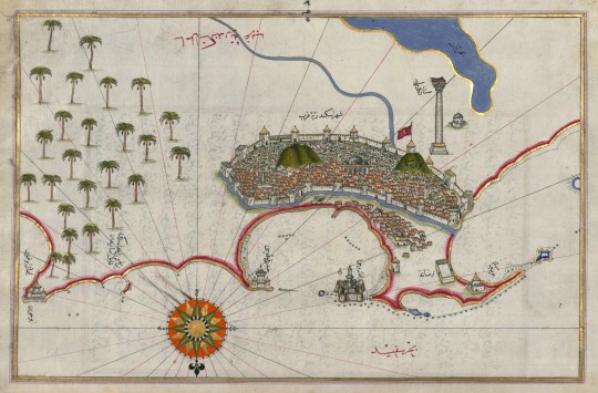
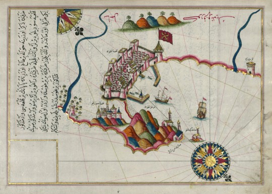
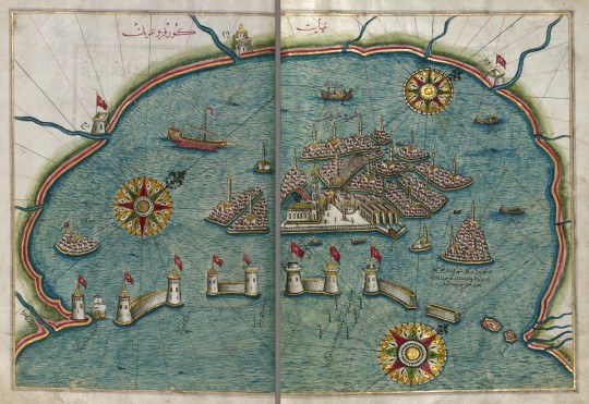
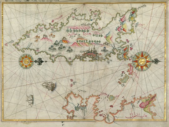
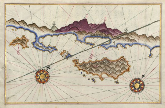
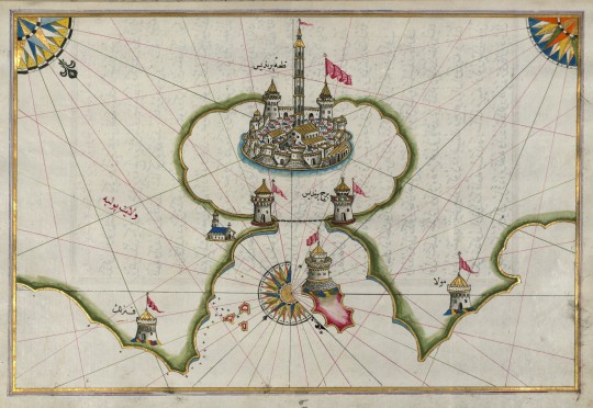
maps from top to bottom: city of alexandria, fortress of ancona, venice, island of chios, island off the coast of fineke, port of brindisi
[map source]
1 note
·
View note
Text
The Piri Reis Map

Piri Re'is
The Piri Reis Map, one of several enigmatic maps drawn in the 15th Century and earlier, presents a puzzle. It holds more accurate information about the shape of the continents than should have been known at the time, sparking intrigue and curiosity.
The Piri Reis map, created by Ottoman-Turkish cartographer Ahmed Muhiddin Piri in 1513, has attracted significant attention due to its depiction of an ice-free Antarctic coastline. If this is true, someone had discovered and mapped Antarctica centuries before its reported discovery in 1773. This revelation challenges our understanding of history and raises intriguing questions about the capabilities of ancient civilizations. Could they know the world is only known to modern science, such as the structure and function of DNA, or advanced astronomy and physics?

The Piri Reis Map is only one of several strange maps drawn in the 15th Century and earlier, and it appears to represent better information about the shape of the continents than should have been known at the time. In 1929, Director Halil Edhem went through the basement of a Turkish palace looking for old maps at the request of German theologian Gustav Adolf Deissmann. Edhem happened upon a very mysterious artifact. A small map was inked onto animal skin, although only a fragment remained. At first, it looked like any other aged map. However, upon closer inspection, something caught Deissmann's attention. It was ultimately identified as the Piri Reis map, incorporating the only known copy of Christopher Columbus' map.
The Piri Reis map is one of the cornerstones of the growing body of evidence for an unknown Ice Age civilization. This civilization existed during the last glacial period, leaving intriguing artifacts and mysteries behind. The Piri Reis map, with its accurate depictions and advanced cartographic techniques, is a testament to this civilization's knowledge and capabilities.
The Piri Reis map showed Antarctica's coastline and the proportions of the continent without its ice cap, which were only visible over 6,000 years ago. Our modern knowledge of the coastline under the ice was obtained using seismic-sounding data. This technique involves sending sound waves into the ground and measuring the time it takes to bounce back from Antarctic expeditions in the 1940s and 50s.

This data allowed us to map the coast under the Antarctic glaciers. The other way to map these coastlines would be to have surveyed them when they were ice-free. According to Hapgood, who based the claim on 1949 core samples from the Ross Sea, the last time the particular area shown in the Piri Reis map was free of ice was more than 6000 years ago. More recent studies show that this may be off by a couple of magnitude. In any case, this geography should have been unknown to the ancients. If this is correct, there are some big mysteries to explain.
In 1965, Professor Charles Hapgood from the University of New Hampshire and his students scrutinized the Piri Reis map. They were not only intrigued by its depiction of the Antarctica coastline but also by another peculiar anomaly. The map had been created using the Mercator Projection, a method of map-making that allowed for a more accurate curvature when transferring maps from paper to globe. This was a technique that European cartographers didn't adopt until 1569, making the Piri Reis map a testament to advanced cartographic techniques that were seemingly ahead of their time.
Hapgood concluded that a civilization with high seafaring and mapping skills surveyed the entire Earth in the ancient past. They left maps that have been copied by hand through many generations. The Piri Re'isRe'is map is a patchwork with gaps (most notably the Drake Passage between South America and Antarctica) that can be explained as non-overlapping areas between the source maps. Maps of the Ancient Sea Kings. Based on what we know, ancient civilizations needed the tools or capabilities to map continents on such a grand scale. Do you know how it could have been achieved? Scholars and historians began to speculate. Paranormal researchers pointed to some extraterrestrial assistance. Others hypothesized the possible involvement of a civilization based around the Lost City of Atlantis. Does the map show an ice-free Antarctica from over 6,000 years ago? Is it proof that an alien technology once existed on Earth?
#aliens#history#science#ufology#mytholog#religions#space#news#writers on tumblr#conspiracy theories#conspiracies#ancient history#forbidden knowledge#truth reading#truthrevealed
4 notes
·
View notes
Text

EL MISTERIOSO MAPA DE PIRI REIS
En 1929 se descubrió en Estambul un mapa dibujado en 1513 un cartógrafo otomano.. Su análisis ha sido objeto de acalorados debates ya que en él se muestra lo que parecen ser las costas de América y de la Antártida, antes de que estas fueran exploradas.
El teólogo Gustav Adolf Deissman hizo esto sorprendente descubrimiento mientras inspeccionaba la biblioteca del Palacio de Topkapi en Estambul, que el gobierno turco le había encargado clasificar.
Entre las estantes polvorientas encontró dos fragmentos de un mapa de principios del siglo XVI, dibujado sobre piel de gacela, que presentaba una extraña anomalía: al oeste de la península Ibérica y de África se podían distinguir grandes porciones de costa que parecían corresponder a América y a la Antártida y que no deberían haber estado allí ya que, por aquel entonces, no eran conocidas en Europa.
El autor del mapa era Ahmed Muhiddin Piri, más conocido como Piri Reis, un marino y cartógrafo otomano que vivió entre 1465 y 1553. Según sus propias palabras, lo había elaborado a partir de otro mapa -hoy perdido- obtenido de un prisionero castellano que había acompañado a Cristóbal Colón en sus viajes, y lo había completado con información procedente de “los antiguos reyes del mar”.
Aproximadamente un tercio del mapa que sobrevive muestra las costas occidentales de Europa, el norte de África y la costa de Brasil. Se muestran varias islas del Atlántico, incluidas las Azores y las Islas Canarias, así como la mítica isla de Antillia y posiblemente, Japón.
El aspecto más desconcertante del Mapa de Piri Reis es su representación de la Antártida. El mapa no solo muestra una masa de tierra cerca de la actual Antártida, sino que muestra la topografía de la Antártida sin estar enmascarada por el hielo y con gran detalle.
Pero según los libros de historia, el primer avistamiento confirmado de la Antártida ocurrió en 1820 por la expedición rusa de Mikhail Lazarev y Fabian Gottlieb von Bellingshausen. Por otro lado, se ha estimado que la Antártida ha estado cubierta de hielo durante unos 6000 años.
0 notes
Video
youtube
Mapas Documentados Antiquísimos revelan Civilizaciones Prehistóricas 1080p HD
“Embárcate en un viaje a través del tiempo y el espacio con ‘Mapas Documentados Antiquísimos revelan Civilizaciones Prehistóricas’. Este vídeo te llevará a un fascinante recorrido por los misterios de la cartografía antigua, desde los sorprendentes detalles del mapa de Piri Reis hasta las maravillas ocultas en otros mapas de la época. Descubre cómo estos mapas no solo representaban el mundo conocido, sino que también revelaban la existencia de civilizaciones prehistóricas avanzadas. Prepárate para desentrañar los secretos de la historia y explorar las maravillas de nuestro pasado.
” Nadie sabe explicar por qué existe este mapa: el misterio de Piri Reis Presentado por primera vez en 1513 en Constantinopla, existen muchas teorías sobre este planisferio, algunas de ellas muy sorprendentes.
Fechado en el año 919 del calendario musulmán, correspondiente a 1513 en el cristiano, el mapa original de Piri Reis no suele estar expuesto al público, lo que no evita que mantenga una cierta popularidad y que sigan pululando múltiples teorías sobre su significado. La primera rareza: no se trata de un mapa europeo, ya que el cartógrafo que lo pintó, Ahmed Muhiddin Piri (Piri Reis), vivió durante la época del Imperio otomano en la ciudad turca de Galípoli.
Como veremos en diversos vídeos que están insertados en esta Publicación, a la que ya pueden acceder un poco más abajo, la verdadera historia de la humanidad, está comenzando a ser sacada a la luz, aunque aún los obstáculos y la desinformación es muy sutil pero fuertemente utilizada para confundir la lógica y la razón de aquellos que no somos especialistas en estas Difíciles y muy diversas disciplinas de las Ciencias, tanto arqueológicas, como de ingeniería a las que se están sumando toda la tecnología desarrollada mediante la computación como el L.I.D.A.R. https://logosconocimientos.blogspot.c...
Únase a nosotros para alimentar nuestra misión de crear vídeos perspicaces respaldados por una investigación en profundidad apoyándonos PayPal: https://www.paypal.com/donate/?hosted... Tu apoyo puede ayudarnos a profundizar en temas importantes, permitiéndonos producir contenidos convincentes que informan e inspiran. Al contribuir, no sólo está apoyando un proyecto, sino que está permitiendo que se comparta una gran cantidad de conocimientos. Apóyenos en nuestros esfuerzos por dar vida a vídeos significativos. Cada contribución cuenta.
#youtube#misterios arqueologia arqueologiaprohibida misterios conocimientos MisteriosDelPasado Documental Historia Cultura Turquía civilizacionesper
0 notes
Photo

Kitab-i Bahriye (Book of Navigation), by Piri Reis
370 notes
·
View notes
Text
El enigmático mapa de Piri Reis.
El enigmático mapa de Piri Reis.
En 1929 se descubrió en Estambul un mapa dibujado en 1513 por el cartógrafo otomano Piri Reis. Su análisis ha sido objeto de acalorados debates ya que en él se muestra lo que parecen ser las costas de América y de la Antártida, antes de que estas fueran exploradas.
el 9 de octubre de 1929, el teólogo Gustav Adolf Deissman hizo un sorprendente descubrimiento mientras inspeccionaba la biblioteca…

View On WordPress
2 notes
·
View notes
Text
Прыжок Веры
read it on the AO3 at https://ift.tt/38VVNVv
by BloodyLadyMary
До этого дня я вел обычную жизнь, пока меня не попытались похитить из-за воспоминаний моего предка Колина, жившего в шестнадцатом веке. Последователи древнего ордена Тамплиеров… Ассасины говорят, что с помощью Анимуса они хотят изучить прошлое Колина. Мое прошлое.
У Ассасинов тоже есть Анимус, его собрала Ребекка. Шон утверждает, что Тамплиеры ищут артефакт, он называется Частица Эдема. Колину приходилось сталкиваться с ним? Не знаю, так ли это…
Меня зовут Персиваль Грейвз, и это моя история.
__________________________________________________
Предыстория событий канона как в прошлом, так и в настоящем.
В Анимусе сюжетная ветка предшествует приключениям Эцио Аудиторе в Константинополе из Assassin's Creed Revelations.
Words: 12050, Chapters: 2/?, Language: Русский
Fandoms: Fantastic Beasts and Where to Find Them (Movies), Assassin's Creed - All Media Types, Fantastic Beasts and Where to Find Them (Movies) RPF, Chocolat (2000)
Rating: Explicit
Warnings: Graphic Depictions Of Violence
Categories: Gen, M/M
Characters: Credence Barebone, Original Percival Graves, Colin Farrell, Ezra Miller, Shaun Hastings, Rebecca Crane, Jacob Kowalski, Yusuf Tazim, Tarik Barleti, Langdon Shaw, Henry Shaw Junior, Roux (Chocolat), Haci Ahmed Muhiddin Piri | Piri Reis
Relationships: Colin Farrell/Ezra Miller, Credence Barebone/Original Percival Graves
Additional Tags: Drama, Alternate Universe - Historical, Alternate Universe, Romance, Action/Adventure, Resolved Sexual Tension, Violence, Crossover, Slow Burn, Out of Character, Pre-Canon, Minor Character Death
read it on the AO3 at https://ift.tt/38VVNVv
2 notes
·
View notes
Photo

In Game:
Haci Ahmed Muhiddin Piri, more commonly known as Piri Reis for his legendary stature in the Ottoman Navy, was a famed admiral and cartographer.
Unknown to most, Piri was also a member and a Master Assassin of the Ottoman Brotherhood of Assassins. Though not involving himself in missions of violence, Piri served the Assassins as a technician, primarily providing them with materials and methods for crafting bombs.
He was a trusted friend of the Ottoman Assassin leader Yusuf Tazim, and also later befriended Ezio Auditore da Firenze, the Mentor of the Italian Brotherhood.
In 1503, Piri resided in Constantinople in order to shift his interests to a more intellectual area, setting up a small studio in the Grand Bazaar, where he began to study cartography.
That same year, a group of Italian Assassins sent from Rome to Constantinople by Ezio Auditore infiltrated Piri Reis' shop to steal some of his maps detailing the New World, in order to match the Templars' expansion into the new lands
Despite his earlier conflict with the Assassins, Piri joined the Ottoman Assassin Brotherhood in 1506 to serve as a scholar and technician, and even eventually progressed to the rank of Master Assassin.
Having witnessed and grown tired of the many artificial boundaries that had divided the nations he had traveled to, Piri was drawn to the Assassin philosophy, which he saw as the "truest intellectual freedom."
Piri invented specialized bomb variants and casings, all specifically for the Assassins' use. These he offered for a price at his workshop, given that those who wished to buy them were willing to learn how to use them first.
In 1511, Piri heard of Ezio Auditore's arrival in Constantinople from Yusuf, and met the Mentor himself shortly afterwards. Yusuf had directed Ezio to Piri to ask for directions to the trading post of Niccolò and Maffeo Polo, which Piri readily gave. The cartographer also introduced Ezio to the variety of bombs he had for sale, as well as offered to instruct him in their use.

Over time, as the Assassins Guild completed contracts all over the Mediterranean, Piri would periodically ask for their help in surveying the region, in order to aid in his cartography efforts. Additionally, when any new city came under the control of the Assassins, Piri would receive special bomb ingredients from the region, and place them for sale in his Grand Bazaar shop.
Ezio discovered the delivery of several firearms to equip the Byzantine Templar army, and reported his findings to Prince Suleiman I. Suleiman ordered Piri to bring Ezio safely to Derinkuyu, where the Templars' headquarters was located.
Despite the Janissaries' attempts to stop any ships from leaving by raising the Great Chain across the Golden Horn, Ezio managed to destroy it with a bomb that had "fifty times the kick of [the Assassins'] regular bombs", and set the Ottoman fleet ablaze with Greek Fire. Piri only commented on Ezio's less than subtle approach, before setting sail.
After arriving at Cappadocia in 1512, Piri awaited Ezio aboard his ship, as the Mentor set off to kill the Byzantine heir and Templar Manuel Palaiologos, and to retrieve the last of the Masyaf Keys. After Ezio had succeeded, setting much of the underground city into chaos after destroying their armory, he returned to the ship, which Piri directed back to Constantinople.
In Real Life:
For many years, little was known about the identity of Piri Reis. The name Piri Reis means Captain Piri (Reis is not part of his proper name). Today, based on the Ottoman archives, it is known that his full name was "Hacı Ahmed Muhiddin Piri" and that he was born either in Gelibolu (Gallipoli) on the European part of the Ottoman Empire (in present-day Turkish Thrace), or in Karaman (his father's birthplace) in central Anatolia, then the capital of the Beylik of Karaman (annexed by the Ottoman Empire in 1487). The exact date of his birth is unknown. His father's name was Hacı Mehmed Piri. The honorary and informal Islamic title Hadji in Piri's and his father's names indicate that they both had completed the Hajj (Islamic pilgrimage) by going to Mecca during the dedicated annual period.
Piri began engaging in government-supported privateering when he was young, in 1481, following his uncle Kemal Reis, a well-known corsair and seafarer of the time, who later became a famous admiral of the Ottoman Navy. During this period, together with his uncle, he took part in many naval wars of the Ottoman Empire against Spain, the Republic of Genoa and the Republic of Venice, including the First Battle of Lepanto (Battle of Zonchio) in 1499 and the Second Battle of Lepanto (Battle of Modon) in 1500.

(Image source)
Piri is the author of the Kitāb-ı Baḥrīye, or "Book of the Sea", one of the most famous cartographical works of the period. The work was first published in 1521, and it was revised in 1524-1525 with additional information and better-crafted charts in order to be presented as a gift to Suleiman I. The revised edition had a total of 434 pages containing 290 maps.
Piri’s most famous work, however, is simply known as the “Piri Reis Map,” which was compiled in 1513 from military intelligence. Approximately one third of the map survives; it shows the western coasts of Europe and North Africa and the coast of Brazil with reasonable accuracy. Various Atlantic islands, including the Azores and Canary Islands, are depicted, as is the mythical island of Antillia and possibly Japan.The map's historical importance lies in its demonstration of the extent of global exploration of the New World by approximately 1510, and in its claim to have used a map of Christopher Columbus, otherwise lost, as a source. Piri also stated that he had used ten Arab sources and four Indian maps sourced from the Portuguese. More recently, the map has been the focus of pseudohistoric claims for the pre-modern exploration of the Antarctic coast.

(Image source)
Piri Reis continued his naval campaigns for many years, even eventually rising to the rank of Reis (admiral) as the Commander of the Ottoman Fleet in the Indian Ocean and Admiral of the Fleet in Egypt, headquartered in Suez. He then returned to Egypt, an old man approaching the age of 90. When he refused to support the Ottoman Vali (Governor) of Basra, Kubad Pasha, in another campaign against the Portuguese in the northern Persian Gulf, Piri Reis was beheaded in 1553.
Sources:
https://en.wikipedia.org/wiki/Piri_Reis
https://en.wikipedia.org/wiki/Piri_Reis_map
http://www.crystalinks.com/pirireis.html
http://muslimheritage.com/article/piri-reis-genius-16th-century-ottoman-cartographer-and-navigator
16 notes
·
View notes
Text
The truth behind one of the Worlds first maps.
The truth behind one of the Worlds first maps.
The story of one of the worlds first maps drawn by an Ottoman Geographer and sailor Ahmed Muhiddin Piri, who took the notes of Christopher Columbus into consideration, dates back to reign of Sultan Beyazid II . Before exploring the American Continents Columbus appealed to the Portuguese King for support, but the king rejected him. Thus, he sends a message to Ottoman Sultan via a clergyman and…

View On WordPress
0 notes
Text
Piri Reis
Piri Reis (full name Hacı Ahmed Muhiddin Piri - Hajji Ahmed Muhiddin Piri, Ahmed ibn-i el-Hac Mehmed El Karamani; Reis was a Turkish military rank akin to that of captain) was an Ottoman admiral, geographer and cartographer born between 1465 and 1470. He died in 1553.[1]He is primarily known today for his maps and charts collected in his Kitab-ı Bahriye (Book of Navigation), a book that contains detailed information on navigation, as well as very accurate charts (for their time) describing the important ports and cities of the Mediterranean Sea. He gained fame as a cartographer when a small part of his first world map (prepared in 1513) was discovered in 1929 at the Topkapı Palace in Istanbul. His world map is the oldest known Turkish atlas showing the New World, and one of the oldest maps of America still in existence anywhere (the oldest known map of America that is still in existence is the map drawn by Juan de la Cosa in 1500). Piri Reis' map is centered on the Sahara at the latitude of the Tropic of Cancer.[2]
In 1528 Piri Reis drew a second world map, of which a small fragment (showing Greenland and North America from Labrador and Newfoundland in the north to Florida, Cuba, Dominican Republic, Jamaica and parts of Central America in the south) still survives. For many years, little was known about the identity of Piri Reis. His name, roughly translated, means Captain Piri.[4] Today, based on the Ottoman archives, we know that his full name was "Hadji Ahmed Muhiddin Piri"[5] and that he was born either in Gelibolu (Gallipoli) on the European part of the Ottoman Empire (in present-day Turkish Thrace),[6][7] or in Karaman (his father's birthplace) in central Anatolia,[8] then the capital of the Beylik of Karaman (annexed by the Ottoman Empire in 1487). The exact date of his birth is unknown. The honorary and informal Islamic title Hadji (Turkish: Hacı) in Piri's (Hadji Ahmed Muhiddin Piri) and his father's (Hadji Mehmed Piri) names indicate that they had completed the Hajj (Islamic pilgrimage) by going to Mecca during the dedicated period of Hadjj and fulfilling the required rituals.
He was the son of Hadji Mehmed Piri, and began engaging in government-supported privateering (a common practice in the Mediterranean Sea among both the Muslim and Christian states of the 15th and 16th centuries) when he was young, in 1481, following his uncle Kemal Reis,[9] a well-known corsair and seafarer of the time, who later became a famous admiral of the Ottoman Navy.[6] During this period, together with his uncle, he took part in many naval wars of the Ottoman Empire against Spain, the Republic of Genoa and the Republic of Venice, including the First Battle of Lepanto (Battle of Zonchio) in 1499 and Second Battle of Lepanto (Battle of Modon) in 1500. When his uncle Kemal Reis died in 1511 (his ship was wrecked by a storm in the Mediterranean Sea, while he was heading to Egypt), Piri returned to Gelibolu, where he started working on his studies about navigation.
By 1516, he was again at sea as a ship's captain in the Ottoman fleet. He took part in the 1516–17 Ottoman conquest of Egypt. In 1522 he participated in the Siege of Rhodes against the Knights of St. John, which ended with the island's surrender to the Ottomans on 25 December 1522 and the permanent departure of the Knights from Rhodes on 1 January 1523 (the Knights relocated briefly to Sicily and later permanently to Malta). In 1524 he captained the ship that took the Ottoman Grand Vizier Pargalı İbrahim Pasha to Egypt.
In 1547, Piri had risen to the rank of Reis (admiral) as the Commander of the Ottoman Fleet in the Indian Ocean and Admiral of the Fleet in Egypt, headquartered in Suez. On 26 February 1548 he recaptured Aden from the Portuguese, followed in 1552 by the capture of Muscat, which Portugal had occupied since 1507, and the strategically important island of Kish. Turning further east, Piri Reis captured the island of Hormuz in the Strait of Hormuz, at the entrance of the Persian Gulf. When the Portuguese turned their attention to the Persian Gulf, Piri Reis occupied the Qatar peninsula and the island of Bahrain to deprive the Portuguese of suitable bases on the Arabian coast. He then returned to Egypt, an old man approaching the age of 90. When he refused to support the Ottoman Vali (Governor) of Basra, Kubad Pasha, in another campaign against the Portuguese in the northern Persian Gulf, Piri Reis was beheaded in 1553. Several warships and submarines of the Turkish Navy have been named after Piri Reis.
Kitab-ı Bahriye (Book of Navigation): 1521 and 1525
Piri Reis is the author of the Kitab-ı Bahriye, one of the most famous pre-modern books of navigation, including a world map. Although he was not an explorer and never sailed to the Atlantic, he compiled over twenty maps of Arab, Spanish, Portuguese, Chinese, Indian and older Greek origins into a comprehensive representation of the known world of his era.[10] This work included the recently explored shores of both the African and American continents; on his first World Map of 1513, he imprinted the description "these lands and islands are drawn from the map of Columbus."[11] In his text, he also wrote that he used the "maps drawn in the time of Alexander the Great" as a source, but most likely he had mistakenly confused the ancient Greek geographer Ptolemy of the 2nd century AD with the same named General of Alexander (of six centuries before) since his map is similar with the Jan of Stobnica famous reproduction map of Ptolemy, printed in 1512.[12]
The ancient book had been translated in Turkish after a personal order of Mehmed II some decades before.[13] It can be seen that the Atlantic part of the map originates with Columbus because of the errors it contains (such as Columbus’ belief that Cuba was a continental peninsula)[14] since at the time the manuscript was produced, the Spaniards had already been in Mexico for two years. Apart from the maps, the book also contained detailed information on the major ports, bays, gulfs, capes, peninsulas, islands, straits and ideal shelters of the Mediterranean Sea, as well as techniques of navigation and navigation-related information on astronomy, together with information about the local people of each country and city and the curious aspects of their culture. There are thirty legends around the world map, twenty-nine in Turkish and one in Arabic; the latter gives the date as the Muharrem month of 919 AH (corresponding to the Spring of 1513 AD) but most studies have identified the more probable date of completion as 1521.[15][16][17]
It was revised in 1524-1525 with additional information and better-crafted charts in order to be presented as a gift to Suleiman I. The revised edition had a total of 434 pages containing 290 maps. Kitab-ı Bahriye has two main sections, with the first section dedicated to information about the types of storms; techniques of using a compass; portolan charts with detailed information on ports and coastlines; methods of finding direction using the stars; and characteristics of the major oceans and the lands around them. Special emphasis is given to the discoveries in the New World by Christopher Columbus and those of Vasco da Gama and the other Portuguese seamen on their way to India and the rest of Asia.
The second section is entirely composed of portolan charts and cruise guides. Each topic contains the map of an island or coastline. In the first book (1521), this section has a total of 132 portolan charts, while the second book (1525) has a total of 210 portolan charts. The second section starts with the description of the Dardanelles Strait and continues with the islands and coastlines of the Aegean Sea, Ionian Sea, Adriatic Sea, Tyrrhenian Sea, Ligurian Sea, the French Riviera, the Balearic Islands, the coasts of Spain, the Strait of Gibraltar, the Canary Islands, the coasts of North Africa, Egypt and the River Nile, the Levant and the coastline of Anatolia. This section also includes descriptions and drawings of the famous monuments and buildings in every city, as well as biographic information about Piri Reis who also explains the reasons why he preferred to collect these charts in a book instead of drawing a single map, which would not be able to contain so much information and detail.
A century after Piri's death and during the second half of the 17th century, a third version of his book was produced, which left the text of the second version unaffected while enriching the cartographical part of the manuscript. It included additional new large-scale maps, mostly copies of the Italian (from Battista Agnese and Jacopo Gastaldi) and Dutch (Abraham Ortelius) works of the previous century. These maps were much more accurate and depict the Black Sea, which was not included in the original.[18]
Copies of the Kitab-ı Bahriye are found in many libraries and museums around the world: Copies of the first edition (1521) are found in the Topkapı Palace, the Nuruosmaniye Library and the Süleymaniye Library in Istanbul, the Library of the University of Bologna, the National Library of Vienna, the State Library of Dresden, the National Library of France in Paris, the British Museum in London, the Bodleian Library in Oxford and the Walters Art Museum in Baltimore. Copies of the second edition (1525) are found in the Topkapı Palace, the Köprülüzade Fazıl Ahmed Paşa Library, the Süleymaniye Library and the National Library of France.
In popular culture
The Piri Reis maps are mentioned in Erich von Däniken's 1968 bestseller Chariots of the Gods?, Unsolved Mysteries of the Past.
Piri Reis features in Ubisoft's Assassin's Creed: Revelations. In the video game set in 1511 AD, he has taken leave from the Sultan's Navy to work on chart and map making at Constantinople. He is portrayed as a member of the Assassin Order; his greatest contribution to the game is teaching the main character Ezio Auditore how to better use Ottoman bombs.[19]
Piri Reis' maps are referenced in the novel The Space Vampires, in which it states that Reis used extraterrestrial information to increase the accuracy of his maps.
Piri Reis appears in Koei's Uncharted Waters: New Horizons video game. He is a recruitable NPC of Turkish Loyalty and wanders in Turkish ports until either recruited by a player or begins to command a battle fleet for the Turkish navy. His name is spelled Pilly Reis however. He is the highest level and therefore hardest NPC to recruit..
#United States#Topkapı Palace#Piri Reis#Ottoman Empire#Mediterranean Sea#Juan de la Cosa#Istanbul#Hajj
0 notes
Text
Прыжок Веры
read it on the AO3 at https://ift.tt/38VVNVv
by BloodyLadyMary
До этого дня я вел обычную жизнь, пока меня не попытались похитить из-за воспоминаний моего предка Колина, жившего в шестнадцатом веке. Последователи древнего ордена Тамплиеров… Ассасины говорят, что с помощью Анимуса они хотят изучить прошлое Колина. Мое прошлое.
У Ассасинов тоже есть Анимус, его собрала Ребекка. Шон утверждает, что Тамплиеры ищут артефакт, он называется Частица Эдема. Колину приходилось сталкиваться с ним? Не знаю, так ли это…
Меня зовут Персиваль Грейвз, и это моя история.
__________________________________________________
Предыстория событий канона как в прошлом, так и в настоящем.
В Анимусе сюжетная ветка предшествует приключениям Эцио Аудиторе в Константинополе из Assassin's Creed Revelations.
Words: 12050, Chapters: 2/?, Language: Русский
Fandoms: Fantastic Beasts and Where to Find Them (Movies), Assassin's Creed - All Media Types, Fantastic Beasts and Where to Find Them (Movies) RPF, Chocolat (2000)
Rating: Explicit
Warnings: Graphic Depictions Of Violence
Categories: Gen, M/M
Characters: Credence Barebone, Original Percival Graves, Colin Farrell, Ezra Miller, Shaun Hastings, Rebecca Crane, Jacob Kowalski, Yusuf Tazim, Tarik Barleti, Langdon Shaw, Henry Shaw Junior, Roux (Chocolat), Haci Ahmed Muhiddin Piri | Piri Reis
Relationships: Colin Farrell/Ezra Miller, Credence Barebone/Original Percival Graves
Additional Tags: Drama, Alternate Universe - Historical, Alternate Universe, Romance, Action/Adventure, Resolved Sexual Tension, Violence, Crossover, Slow Burn, Out of Character, Pre-Canon, Minor Character Death
read it on the AO3 at https://ift.tt/38VVNVv
0 notes
Text
You Should Know About The Famous Ottoman Cartographer Piri Reis
Hacı Ahmed Muhiddin Piri, known as Piri Reis was an admiral in the great Ottoman Imperial navy and the man whose world map is the oldest known Turkish atlas which shows the New World. This world map is also the oldest map of American still in existence.
Piri Reis’ Identity in the Ottoman Archives:
Many years passed by and very little was known about the identity of Piri Reis until the Ottoman…
View On WordPress
0 notes
Text
Antártida sem gelo e habitada por extraterrestres
Antártida sem gelo e habitada por extraterrestres
Mapa de Piri Reis.
(Clique na Imagem para Amplia-la)
Antártida sem gelo e habitada por extraterrestres
Antártida sem gelo e habitada por extraterrestres. Um mapa, desenhado em 1513 por um almirante turco, parece mostrar a costa da Antártida sem gelo algum. Dezenas de teorias foram propostas para explicar o mistério do mapa de Piri Reis.
Haji Ahmed Muhiddin Piri era almirante da Marinha turca no…
View On WordPress
#Alienigenas#Antártida#Area 51#Brasil#CIA#Contato#Disco Voadores#EBE#espaço#ET#Extraterrestre#Extraterrestres#gelo#KGB#Marte#Mistérios#Nasa#Nave Espacial#Ovni#Ovnis#Pirâmides#Rainha Maud#Roswell#Ufo#Ufos
0 notes
Photo

Venice, Kitab-i Bahriye (Book of Navigation), 1525, by Piri Reis
39 notes
·
View notes
Text
Granada, 1521
Granada, 1521 Source: History Today {$inline_image} Granada, 1521 By Kate Wiles Ahmed Muhiddin Piri (1465/70-1553), was an Ottoman admiral and cartographer, better known as Piri Re’is (Re’is is a Turkish naval rank, akin to captain). He was the cartographer, in 1513, of one of the oldest surviving maps to show America, produced at the peak of the Ottoman Empire’s power. It was…
View On WordPress
0 notes
Quote
Piri Reis (nama lengkap Hacı Ahmed Muhiddin Piri (Hadji Ahmed Muhiddin Piri); Reis (Rais) berarti K
Biografi Piri Reis, Kartografer Muslim Terkemuka di Dunia
0 notes
Last Seen Blogs

of-monsters-and-werewolves
'It wasn't about the wedding...'

order-local
Untitled

yung-paperboy
yung-paperboy

zothji
zothji

amanoaki
intricate aki