#geospatialscience
Text
Geoinformatics Colleges in India: A Comprehensive Guide
Are you passionate about geospatial technology and its applications? Do you want to pursue a career in geoinformatics? If so, you've come to the right place! In this article, we will explore the top geoinformatics colleges in India and provide you with all the information you need to make an informed decision about your future.

What is Geoinformatics?
Before we dive into the details of geoinformatics colleges in India, let's first understand what geoinformatics is all about. Geoinformatics is an interdisciplinary field that combines geography, geology, computer science, and information technology to analyse and interpret spatial data. It involves the use of various tools and techniques to collect, store, process, analyse, and visualise geographic information.
Courses offered for Geoinformatics
If you're interested in pursuing a career in geoinformatics, it's important to know what courses are available and what they entail. Here are some geoinformatics course details offered by geoinformatics colleges in India:
1. Bachelor's Degree in Geoinformatics
A bachelor's degree in geoinformatics is the first step towards building a successful career in this field. This course typically spans over three to four years and covers a wide range of topics such as GIS (Geographic Information System), remote sensing, spatial analysis, database management, and cartography. Some colleges also offer specialised courses in areas like environmental management and urban planning.
2. Master's Degree in Geoinformatics
If you want to further enhance your knowledge and skills in geoinformatics, you can pursue a master's degree in this field. A master's degree program usually lasts for two years and provides advanced training in areas such as geospatial data analysis, geodatabase design, web mapping, and geospatial programming. Many colleges also offer research opportunities for students who wish to delve deeper into specific topics.
3. Diploma/Certificate Courses
Apart from bachelor's and master's degree programs, there are also several diploma and certificate courses available for those who want to gain specialised knowledge in specific areas of geoinformatics. These short-term courses focus on topics such as remote sensing applications, GIS software, and spatial data analysis.
Top Geoinformatics Colleges in India
Now that we have a basic understanding of geoinformatics and its course details, let's take a look at some of the top geoinformatics colleges in India:
Indian Institute of Remote Sensing (IIRS)
Indian Institute of Remote Sensing (IIRS), located in Dehradun, Uttarakhand, is another renowned institute that offers excellent programs in remote sensing and geoinformatics. The institute is affiliated with the Indian Space Research Organization (ISRO) and provides world-class training and research opportunities to students.
National Institute of Technology (NIT) Warangal
National Institute of Technology (NIT) Warangal offers a comprehensive program in geoinformatics at both undergraduate and postgraduate levels. The institute has state-of-the-art facilities, well-equipped laboratories, and experienced faculty members who are actively involved in research projects.
Symbiosis Institute of Geoinformatics (SIG)
Located in Pune, Maharashtra, SIG is one of the premier institutes for geoinformatics education in India. It offers a variety of undergraduate, postgraduate, and diploma programs in geoinformatics. The institute has a state-of-the-art infrastructure, experienced faculty members, and strong industry connections, making it an ideal choice for aspiring geospatial professionals.
Scope of Geoinformatics
After completing your education in geoinformatics, you'll have a wide range of career opportunities to explore. Here are some possible MSc geoinformatics scopes:
1. GIS Analyst: As a GIS analyst, you'll be responsible for collecting, analyzing, and interpreting geographic data using GIS software.
2. Remote Sensing Specialist: Remote sensing specialists use satellite imagery and other remote sensing techniques to gather information about the Earth's surface.
3. Spatial Data Scientist: Spatial data scientists analyze spatial data using statistical techniques to derive meaningful insights.
4. Urban Planner: Urban planners use geospatial technology to develop plans for land use, transportation systems, and urban development.
5. Environmental Consultant: Environmental consultants assess the impact of human activities on the environment using geospatial tools.
These are just a few examples of the career paths you can pursue with an MSc degree in geoinformatics. The demand for skilled professionals in this field is growing rapidly, both in India and abroad.
Conclusion
Geoinformatics is a fascinating field that offers exciting career opportunities for those who are passionate about spatial data analysis and interpretation. By pursuing a degree in geoinformatics from one of the top colleges mentioned above, you’ll gain the necessary knowledge and skills to excel in this field. We recommend SIG from Pune as it offers the perfect blend of education and experience you need for your career ahead.
Remember to thoroughly research each college’s curriculum, faculty expertise, infrastructure, and industry connections before making a decision. Good luck with your academic journey!
1 note
·
View note
Photo
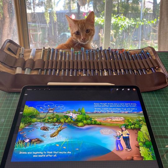
Only a few days to go before the deadline! I’m loving the process of illustrating “Pippa and Dronie” for @shemapsau, but will definitely breathe a sigh of relief once the illustrations are finished and sent to the graphic designer! Anyone who says illustrating kids books is easy has nooooo idea! Like most worthwhile and rewarding jobs, it is hard work. Juggling a chronic illness(#EDS #POTS) means I’ve been forced to be strict with myself, making sure I sleep enough, eat well, and take regular breaks. When I’m in the zone it’s so easy to lose track of time and stay at my desk working for hours and hours, so I’m using a pomodoro timer that lets me know when I’ve done 45 minutes that it’s time for a 5 min break. Getting up and stretching, making sure I’m hydrated, and letting my mind rest in between work sessions means I’m better able to focus and don’t end up hitting the metaphorical brick wall. I have learnt soooo much in this process, about geospatial science, endangered ecosystems, about the way words and pictures work together to tell a story. But also about myself - what I’m capable of, what I can achieve, and the sort of work that I want to invest my time in. I suspected that I would love illustration jobs involving science education, and indeed this is where I want to be... in the playground of ideas...where I can indulge my love of learning, and spend time doing my favourite thing: using art to make tricky concepts understandable, relatable, and located within their wider context... #lovemyjob #sciencecommunication #illustration #illustrator @shemapsau @scbwi_west #pippaanddronie #geospatialscience #drones #geospatialtechnology #scienceeducation #genderequality #girlsinstem #womeninstem #stemeducation #steameducation #sciencenerd #procreate #procreateart #scienceillustration #kidlitart #kidlitartist #childrensbookillustration #onmydesk #wip #kittens #artistsoninstagram #meow https://www.instagram.com/p/CDNUHEGjYSK/?igshid=4lipblnlt90m
#eds#pots#lovemyjob#sciencecommunication#illustration#illustrator#pippaanddronie#geospatialscience#drones#geospatialtechnology#scienceeducation#genderequality#girlsinstem#womeninstem#stemeducation#steameducation#sciencenerd#procreate#procreateart#scienceillustration#kidlitart#kidlitartist#childrensbookillustration#onmydesk#wip#kittens#artistsoninstagram#meow
0 notes
Photo

#Repost @somas.sbu: If you want to find the #scenicstudyspots at @stonybrooku, check out Megan Gallagher's map from Dr. Donna Selch's 2018 GSS 105 course! . Here are the highlights: . In the library, there is a place called the STACKS, where you can have a nice single desk with a charger that overlooks the campus through the windows. . At the @stallercenter, there are nice areas upstairs & on balconies that overlook fountains and the STALLER STEPS, another cute area. . A beautiful place to study is in the HUMANITIES atrium where you can quietly study surrounded by plants & warmth & sunlight. . In Roth Quad, there is a small dining area that has a @Starbucks & a (good) Subway. If you go upstairs, there is a larger seating area that overlooks Roth Pond & trees. . ESS courtyard is a lovely place to study & do work when it's warm outside; the trees fully bloom by May & are very easy to climb. . In the SAC there is a little outdoor area in the middle with tables & flowers, making it a quaint area to read/study. . #SBUtiful #scenicstonybrook #farbeyond #gss #geospatialscience #geography #summeratsbu #summer #summertime https://ift.tt/2vTB2IP
0 notes
Last Seen Blogs
nickname1812
NearlyHeadlessNICKname18


tessflocker
x.Tessflocker.x

no-luscinia-no-amore
the nightingale is just very eepy

letthemusicbe
✨💜 MY YOUTH 💜✨