#mount rainier camp mirror
Text
Back to the Evergreen State
In the beginning, it was my go-to venue, the place where the Northwest Passage series developed. Washington state was a secondary setting in The Journey and The Fire, the primary setting in The Mine and The Show, and the sole setting in The Mirror.
Since then, it has received only one mention, a wedding chapter, set in Vancouver, in The Fountain. That will soon change.
In the book three of the Second Chance trilogy, I will return to my former home state, setting chapters in Camp Lewis, Tacoma, Mount Rainier, and perhaps other venues. I will revisit familiar territory.
Last week, I began researching the series finale by paying a visit to the Lewis Army Museum, part of what is now Joint Base Lewis-McChord. In the process, I learned a lot about Washington's early history, the United States Army, and Camp Lewis, a sprawling city of 37,000. Situated in the shadow of Mount Rainier, it was the largest military post in the country in 1918.
Southern California, the destination of the Carpenters and Lees at the end of Annie's Apple, will also get a turn in book three. So will northern France, the site of some of the fiercest fighting of World War I. Along with Western Washington, the venues will form the foundation of a novel that will bring a family saga to an end.
I intend to research all three places — and others — this spring and summer and begin writing the book itself in early August. I hope to publish the finished work no later than February 2024.
0 notes
Text
Bench and Snow Lakes trail is an out and back trail. No loop here. No alternatives. You start at the trailhead, hike out to Bench and/or Snow Lake, turn around and hike the same trail back. Some folks don’t like out and back trails because of this. It’s the same trail both coming and going. Some people prefer loop trails because you get to see something different all the way along. I would argue the same is true with Bench and Snow Lakes trail.
Bench and Snow Lakes trail is not the longest trail. It’s only about 2.6 miles roundtrip. It’s not the flattest or steepest trail in the park either, about 700 feet of elevation change total. But in a way, it’s like 2 different trails. Starting from the trailhead and going out, you’re moving through groves of trees and meadows and looking up to the Tatoosh Mountain Range. These beautiful mountains are made of granodiorite about 14-18 million years old.
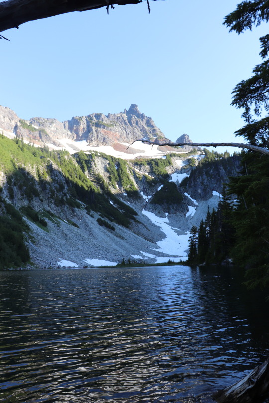
Less than a mile in, the trail brings you to the side of Bench Lake. Follow the trail further into the Tatoosh Mountains, you get a great view of one Tatoosh peak in particular. About half a mile from Bench Lake you’ll find Snow Lake nestled at the bottom of Unicorn Peak. And now for the second act, you turn around to hike back to your car at the trailhead. Along the way you get awesome views of Mount Rainier. It’s almost like a completely different trail. Which views are your favorite on the Bench and Snow Lakes trail? Do you prefer the more ancient Tatoosh Range or the young volcano towering over 14,000 feet above sea level? ~ams

For more information on this trail https://www.nps.gov/mora/planyourvisit/bench-snow-lake-trail.htm The parks’ webpage for Current Trails Conditions https://www.nps.gov/mora/planyourvisit/trails-and-backcountry-camp-conditions.htm can help with planning. If you’re thinking of taking advantage of the backcountry campsite at Snow Lake, check out this page for info on getting your permit https://www.nps.gov/mora/planyourvisit/wilderness-permit.htm ahead of time. The Paradise area is very popular. Visiting on weekdays, early mornings or evenings can help avoid crowds.
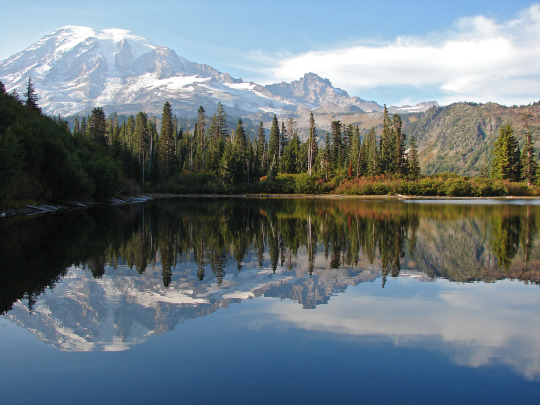
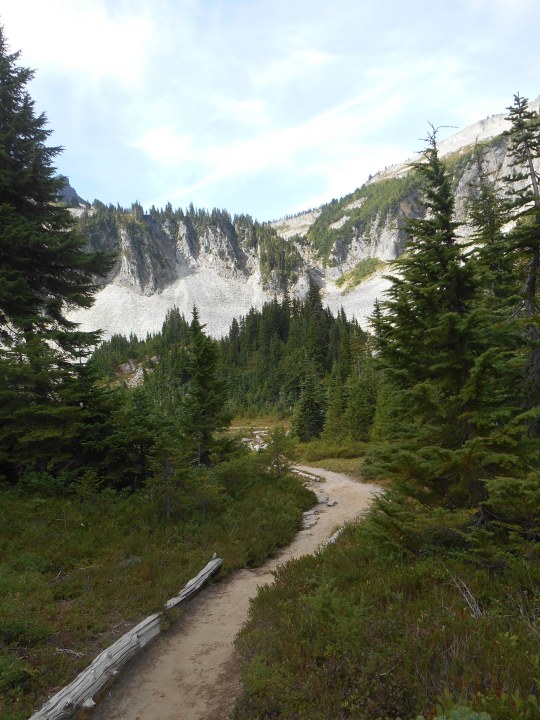
NPS/S. Redman Photo. View across Bench Lake to Mount Rainier and Little Tahoma. Mirror like reflection of mountains visible in lake. September, 2015. NPS/Spillane Photo. Dirt trail through evergreen trees near Snow Lake. Tatoosh Mountains in the background. July, 2015. NPS/I. Metzen Photo. Snow Lake with Unicorn Peak behind it. July, 2018. NPS/Spillane Photo. Dirt trail through meadow with white beargrass flowers and small trees. Mount Rainier in background. July, 2017.
#encuentra tu parque#find your park#mount rainier#hiking#trails#lake#mount rainier national park#national parks#mountains
53 notes
·
View notes
Text
THE SECRET DOCTRINE - The Atlantean Plan - Chapter 1

ONE: The Fall Of Isla de Pascua
Shimmering blue-green waves splash endlessly in an open vastness of the Pacific Ocean. The gently churning of the open ocean places the wary mind at rest as the plane rocks back and forward like a boat at sea.
Ahead, the sea gives way to rocky red earth. A rusty red color breaks the calming ocean blue with white water splashing against the rocks as the waves try to overtake the land but is kept at its limits. The plane pitches against the headwinds that shake the cabin like a tumbler-jar.
Glancing at the reflection of two blue-grey eyes staring back at the observer, he is aware that his hair has become messy from the on-board air. He brushes back his light brown hair with his long slender fingers. His face looking tired and uncertain. The flight has been a long trip! Over 22 hours from his home in British Columbia to this hot, desert-like island out in the middle of nowhere.
‘Isla de Pascua’ Meir thinks as he looks at a geologic map that he has been studying. Meir is what you’d call a free-to-hire geologist. Never working for governments or corporation. People hired him to investigate something geomorphic and, in a month, he usually mails the results to his employer. Meir liked to work unabated, his own boss. But this time he was hired into a group of researchers from around the world. Two names: Jen Kleito, geophysics from Greece and Kiera Azaes, a geology historian from Portugal; were to meet him when he arrives at the airport.
He almost did not take the job when he learned that he was going to have to work with two other individuals; but he needed the money and the price that his employer was paying was…almost to good to be true! Nevertheless, here he was, about to land on Easter Island.
Touching down on the ground, he has finally arrived at the Mataveri International Airport. He closes his eyes as he never really liked flying, and the landing-part scared him the most! The plane rolls down the taxiway as it makes a sharp left turn into the terminal’s parking lot. The plane stops as the engines cut out and he looks outside to see a truck bringing a staircase over for the passengers to disembark. He wondered ‘How do you push a person with a disability down those stairs?’ He could not guess at the time, thinking that the stairs must have some type of ramp from the disabled, but luckily there were no wheelchair bound people on this flight today.
Meir collects his carry-on and exits the plane as he walks over to the luggage being unloaded and takes his two bags; one bag with clothes and one bag with his personal surveying gear. He wipes his forehead as it is hot and muggy outside. It is always hot and muggy on Pascua! He looks ahead, wondering how he is going to find his connection.
Ahead, there is a tall, six-foot-high woman wearing some loose-fitting bright plaid clothes. Her hair is almost white and tied back in a ponytail! Her skin pale white, like it has not seen the sun. She does not look like anyone that would fit the role of a geologist; but in her hands she holds a sign with one word: ‘Rainier’.
Meir smiles as he walks over to the woman as he greets her. “Meir Rainier…you must be?”
She smiles as she puts the penned sign away as she shakes Meir’s hand. “Kiera Azaes.” she says, her voice sounding like it is recovering from a cold.
“It is nice to finally meet you Mrs. Azaes…” as Kiera takes both of his heavy bags with ease without much word from Meir as he was shocked but just goes with it. He hurries to catch up with Kiera as he looks at his bags “It is okay, I can handle my own bags…” he says as she just smiles as she looks towards her park car.
She sets the bags down as David hopes nothing got broken in the flight. With the bags placed in the backseat, Meir takes the passenger’s seat as she takes the drivers seat. She hands a small badge to him to wear. He looks at it “What’s this?” as he looks at the tag: MEIR RAINIER ~ OCEANID ON-LAND EXPLORATION. “Okay? So we are striving to look official?”
Kiera nods as she engages the engine and throws it in drive.
Meir glances around, noticing they are missing one soul “Where is Miss Kleito?” Meir comments as Kiera fills in him.
“She is waiting for us at the research site,” she states as she drives on the outskirt road that separates the airport from Hanga Roa. Meir looks out his window to a gentle slope that seems to just end abruptly. “That is…”
“Rano Kau…” Meir says as he just familiarized himself with the names of all the extinct volcanoes that were wasting away. Easter Island was a dead island, volcanically inactive. At one time, this entire island was covered in vegetation and trees, but deforestation by the ancients have left this place a wasteland. They were heading to the youngest of the volcanoes, Poike.
Keira studies Meir for awhile and can see that he is uncomfortable. “I take it that you don’t work often with others!” she remarks as he turns and glances at her, his eyes furrowed and mouth crinkled like having bit into a lemon.
“No,” he says with a deep breath and sighs “my way of getting my answers and how I conduct geology is not…” as he pauses to find the right word.
“Typical?.” Kiera says as Meir glances at her and lightly smiles. “We all were sought for our ‘odd’ approaches to geology and science. Call it intuition, but we pose talents that the Oceanid…” she pauses and carefully says “…collaboration, needs.” she smiles and adds cheerfully, “Consider us, family!”
Meir turns back to the mountainside as they follow the airport to the other side of the island, 1.4 miles down the taxiway and make a gentle left-hand turn and follow the coast. They slow down as the road looks in bad shape. Keira and Meir look ahead as the road is barely hanging on…the whole land seemed to have fallen off into the ocean as the waves roll over the basalt rocks. There is a look of concern on Keira’s face as she looks at the road. “Think it is safe?” he asks as Kiera pushes the gas, they will soon find out as they skirt the drop off.
Meir is left to wonder how much of the road is like this…and from the look of concern on Keira’s face, something tells him that this was once dry land. He takes out his cell phone and calls up his app that he uses to detect earthquakes. The USGS in California collects all the data and in a few minutes’ releases it to the public. Right off the island, somewhere in the water, there is a new squiggly line; ‘It was an earthquake?’ he wonders.
Clearing the obstacle, they go down the bumpy dirt road as they breathe a sigh of relief. They follow the coast as Meir keeps a weathered eye for any other signs of island collapse and sees small areas that have weathered and worn away, but nothing that looked like that!
Over ancient flat pahoehoe lava flows, the land is flat and unimpressive. There is a rise in front of them and a series of hills in the north, with the tallest now behind them. Meir looks at the water as his eyes widen. A massive crack opens from the ocean and splits across the landscape, racing from the road. “Look!” as he points to the black crack. Keira shakes her head as she does not know what it means. The crack splits the road, Kiera punches it as she hits the crack with a terrible bump. “What the hell!”
“We need to go get Jen!” Kiera says as Jen is at the foot of Mount Poike as the ground begins to quiver. The instruments that she had been setting up all morning rattle. In her mind, she says ‘Earthquake?’ as the history of powerful quakes on Easter Island is rare to almost unheard of! Looking to the east, Mount Poike grows, rises as if the whole earth is was growing upward. Off in the Pacific, powerful explosions erupt rocks high into the sky before raining back down. The Tongariki heads in the southwest, near the coast sway back and forward as the ground she is standing on lifts her into the air. Massive cracks split across the landscape as the ocean floods in a hurry.
The ground buckles and the earth fall back down, knocking over all the heads and the cracks widen and gas explosions from deep within the earth blows lava rocks all over the place. Jen grabs her steel carrying case and covers her head as rocks the size of oranges rain down upon her. Mount Poike begins to collapse, crumbling away in landslides as the ocean splashes against the rocks it 30-foot sprays.
Keira and Meir look ahead as their brains can’t comprehend what their eyes are seeing. Mount Poike rises into the sky…as if the mountain was swelling, ready to erupt. Massive blocks of earth explode out of the ground as Kiera must dodge walls of old basalt. Meir is death-gripping the seat belt as the earth seems to roll, the road disappearing as they drive down a hill only to hit the gravel hard and be pushed back up.
“It’s a rolling earthquake!” Meir says as he has read about these in collage and seen one when he was only 7 years old. It happened at his home on the North Pacific coast of Vancouver Island. The ground rolled like waves on the ocean. He rose and fell with the earth, it was very disorienting!
Kiera lays on her horn as she drives into camp. She and Meir see Jen laying on the ground as they look at Mount Poike sliding away into the sea. Kiera places the car into park and runs over to Jen. Meir gets out to give her a hand...to find that Jen is okay, just a little banged up. The sound of collapsing earth eats away at their nerves as they help Jen to her seat as Meir looks at the mountain break away in blocks, looking as the fractures spread across the island. “We have to move!” he yells at Keira as she looks at what he was looking at, she is frozen with dread. The mountain is gone and the ocean is advancing!
In their car, she turns back the way they came as she looks in her rear-view mirror to watch the whole island dropping off, the ocean roaring towards them. She throws the car into drive as she flies across the landscape. Orange size rocks bang into the car as it startles them every time. She tosses her phone into Meir’s lap. “Open my contacts and call the airport and have them read the plane!” as he looks through her contacts and finds the only name that looked like it would belong to a plane company.
By the time they pass the Rano Raraku splatter cone, he was able to get through as he addressed the person on the other line. “I am calling on behalf of Mrs. Azaes…we need you to get the plane ready to take off!” he commands.
“Who is this?” the man commands in an odd sounding voice.
Meir looks at Kiera, “He wants to know who I am!” he says, annoyed and glancing out the window to the vanishing earth.
“Tell him that you work for the Oceanid On-land Exploration…” she tells him as the man on the phone hears Kiera’s voice as his attitude changes.
“What did Miss Azaes need?”
“Get the plane ready to take off when we arrive! The whole east side of the island is erupting!” he says as he looks into the mirror and see nothing but water! The ocean is higher then he is as he looks wide eyed at Kiera. “The ocean is…?”
“Higher…” she answers, “yeah! We are sinking!” she tells him as the ocean looks like a tsunami as the wave takes out everything. Looking ahead, they climb out of the sink, but it seems to follow them!
Looking ahead, the ocean is racing towards them as the earthquake has taken out the road. Kiera slams on the breaks as she yells. “Damn!” as she looks at Meir. “Wasn’t there a road back there?”
He thinks and nods as they make a U-turn and head north, across the island as they look east to a massive wall of water racing towards them. “Wave!” he shouts as the roar through farming communities, doing about 80 miles per hour, the road is killing the car! Higher and higher they climb, up the side of the largest volcano on the island, the wave is about two miles away, but thanks to the mountain of basalt, it is splitting into two.
Coming to the end of the road, they make a hard-left turn as they resume heading west, away from the chaos. With a view of the city below, the road begins to lift high into the sky as they quickly sink and rise again…but this time, continue to rise as they watch the wave roll through the city as the earthquake overloads transformers as they explode. There are fiery explosions as gas mains break and columns of smoke form. The hill they are on begins to sink as they watch cracks cut through the landscape and across the road.
“It isn’t just the east side!” Kiera says as she punches the gas. They need to get to the airport now! With the airport in view, it was hit bad! The runways are fractured. Kiera continues straight as Meir glances at the turn and realizes that at this speed, they will roll!
“Oh Kiera...the road...you can't...make that turn!” he says as she isn’t distracted and blows across the road and onto an emergency road for the airport. It is blocked by a gate. “Gate! Gate!” he panics as he sees that she isn’t stopping, and he braces for impact. She cuts off the road and slams through the fence as she feels the car’s under carriage be ripped by lava rocks that are naturally scattered all over the island.
On the run way, a commercial jet waits, its engines hot as they pull near the plane. The pilot waving them to hurry as his eyes look upon an island tumbling into the sea. Jen, Meir and Kiera exit the car as Jen and Kiera race to the plane; but Meir will not leave his gear behind. Kiera turns and sees that he is collecting the computers and his luggage.
“Forget it!” Kiera screams. “Leave it!” as the pilot urges her to get onboard. With everything in hand, Meir runs across the taxiway as he begins climbing the stairs, carrying his gear. He feels the ladder shake as the cracks open and fountains of water begin to erupt. He throws the gear into the plane. The ladder falling just as Kiera and Jen grab onto whatever skin they can grab and pull him into the plane.
“Your one crazy sum-of-a-bitch!” Jen says, still bleeding.
“Its water!” Meir says as he looks frantic. “Water is exploding out of the earth!” the jet violently rocks as the captain engages the plane as air traffic control calls him in.
“Passenger jet 377412N 256756W, stand down. You are not clear to go!” the controller commands as the captain ignores the order. He looks ahead, there is nothing in the sky. The plane roars down the runway, being sprayed, pelted and rocked by the airstrips condition as he pitches the jet up and they leave the ground before they expected. Looking out the window, the ground drops off and in front, the ground rises above the plane. The captain white eyed, pulls up as the plane barely makes it over the rise before it falls away and the ocean rolls in.
They circle around as the whole island seems to fracture and break away into massive blocks. The city of Hanga Roa is swept away into the ocean as the ocean replaces land. Only the summit of Ma′unga Terevaka remains above the ocean as the waters churn like mud. The ships in the area are pulled down with the island as there is a rebound, a shockwave radiates away from where Easter Island was. Soon the water rises on the island of Terevaka. A massive tsunami pulls all the soil and life away from the mountain top, leaving a rocky crag.
Jen and Meir stare out the window at the empty place where Easter Island once was. All the ancient history, mystery and lore is gone. Resting somewhere under the Pacific Ocean. No one has an answer. Jen shakes her head, the trauma of seeing her own death still raw. “Never in recorded history has a whole island just sank under the waves.”
“Well, not exactly…” Kiera says as she checks on her passengers “…10 thousand years ago, that happened to the ancient of Atlantis.”
“Atlantis!” Meir says, tired and aching. “Atlantis is a fictional place made-up by Plato.” he says as Kiera just shakes her head.
“And they said that plate tectonics was also fiction…” Kiera offers as Meir returns to looking at the ocean as they are traveling east away from the setting sun. Kiera gets up as she can see that they need some time to reflect what they just saw.
“Where to?” the captain asks as his eyes look to the eastern horizon.
“Sao Miguel…” Kiera says as she takes a seat in the copilot’s seat and stares across the vast Pacific Ocean as they soar through the clouds. The knowledge of what has happened on Easter Island still fresh in her mind. She has much to be grateful, if it wasn’t for Meir’s selfless actions back on the taxiway, all the research and data would have been lost. Years of research, gone. She leans back in the seat as she closes her eyes as the captain glances at her.
“You can go back and get some sleep, I’ll call you once we cross over the Atlantic.” he offers as she shakes her head taking out a needle and vial of blue fluid as she draws some of the fluid into the needle and pushes it into the base of her neck.
Rubbing her sore skin, “I don’t think I could honestly sleep…right now!” as the faces of terror on the people’s faces are still fresh in her memory. No salvation for the people of Easter Island, only death! The captain can see the ethical turmoil in her eyes as he looks back out the window as he stares out across the skyline, watching for other planes and things that might damage his plane.
In the back of the plane, Meir and Jen sit quietly, just staring out the windows as they look out upon the Pacific Ocean. The ocean looks so peaceful and serene. Unaware of the devastation that just occurred on a remote island that most have never visited before.
Meir grows bored of watching the endless blue, so he takes out his phone and pulls up the USGS site to see if they registered the earthquake at Isla de Pascua. He would call to warn someone, but cell service was non-existent out here and only internet was provided by the plane...and it was spotty at time. He looks at a map of the South Pacific Ocean and finds the tiny island of Pascua and sees a massive red alert near the island. It was a massive 9.9, shallow earthquake. Another quake registers near the city of Hanga Hoa as a 9.8 and right under the island, a powerful quake that has the word: ERROR. ‘Error?’ Meir wonders as he pulls up the records and sees that the seismographs were recording a 9.9 before all the graphs abruptly…end. ‘They don’t know what happened to the island!’ he realizes. He then ponders. ‘They think that it was isolated earthquakes, not that the whole island got sucked under the ocean! That much water displacement...’ he realizes that the horror isn’t over as he quickly opens his Facebook app as he can’t text or call and will have to hope someone is reading his page.
‘Just Escaped Easter Island…The Whole Island Is Gone! Massive Seismic Disturbance Has Caused The Island To Disappear Into The Ocean. Please Alert Authorities Of Possible Mega-Tsunami For The South American, Central American, North American, Australia And Asia Coast - Rainier.’
As he hits send, he waits for the message to upload as they near the Galapagos Islands. Meir takes his phone, looking out the window. If there was a mega-tsunami out there…he should see evidence of it here.
In the cockpit, the captain and Keira look out the window as they look across the ocean to the Galapagos Islands. Keira stares at the green island as the white-water lapping at the black rocks begins to pull back rapidly. The shoreline from Isabela Island reaches out for the expanding shoreline of Fernandina Island. Meir, sitting in the cabin watches the water begin to crest as he snaps some pictures of the receding water and the growing tsunami as he jumps out of his seat, startling Jen, as he rushes to the cockpit.
“There is a tsunami!” he shouts as he looks out the window at the islands of Isabela and Fernandina, the water has drawn back so far that now the island of Fernandina is reconnected back to Isabela, where there was once a 50-foot-deep passage. The water begins to rise as the wave seems to rise towards the plane. At an estimated height of around 3000 feet, it is the largest mega-tsunami ever seen by human eyes! The wave rolls up the shore with devastating results as it scours the earth, obliterating old outcrops and throwing rocks the size of houses around.
The wave hits the active volcano of Cerro Azul, the spray impressive as the water explodes high over the summit. Unable to crest the 5000-foot volcano, the wave wraps around the volcano as the tsunami rolls over the lowlands of Isabela Island. On Fernandina island, the water rolls up the gentle slope of the island with little to no obstacles as the water poured into the caldera as the wave rolled through the harbor and crested against the shore of Isabela Island
Flying over Isabela Island, the green earth with its cold black lava flows disappeared under an azul blue wave that towered over the land by almost 2000 feet as it races towards the tiny village of Santo Tomas. Serra Negra volcano cut the strength out of the wave as the volcano completely disappeared under the wave as the force of the wave was split to the north and to the south, right towards the lightly populated city of Puerto Villamil. The city was washed away under a wave that towered over the city by almost 1300 feet as the wave raced towards the airstrip. The captain steers up as a plane rolls down the run way, trying to take off. The wave seems to explode and swallows the plane as it disappears in the tsunami.
Meri is shock shocked that he forgot to take photographs as the devastation is complete. He finally realizes his error as he snaps a few photographs from the cockpit as the wave is now behind the main tsunami. The tsunami overtakes the island of Santa Cruz, wiping the five towns off the map. Meir has seen enough as he leaves the cockpit as Jen stands there at the door, equally devastated as she looks emotionally sick.
“All those poor people!” Jen whispers as Meir looks at his Facebook post, not a single comment! All these people could have been warned. He thinks about the lives in his hometown. By the time the tsunami reaches them, it would have weakened, but still have a wave of around 300 feet! That is pretty much Victoria and his town at Crystal Cove. He uploads the pictures from the Galapagos to his site as they immediately receive views and the comments begin to roll in.
‘Where Is This?’
‘Were You There?’
‘How Tall Is That Wave?’
‘Is This Connected To The Easter Island Earthquake You Mentioned?’
Meir sits down as he looks out the window as they fly over the location of San Cristobal. Only the summit of El Junco rises above the waters surface as the ocean looks muddy. He closes his eyes as he has seen enough. He loves a good disaster, but to watch the world end, it was too much to bear! To watch a 3000-foot wave wipe away everything man has created makes him feel so small. He thinks about all that he has seen, all that he has been through as his thoughts go back years; to a time when he was addressing a pretentious employer from Alaska:
‘What is the likelihood of a mega-tsunami hitting our rig?’ his employer asks him as he never considered mega-tsunami’s much of a threat. They were especially rare in the field of geosciences and hardly studied as the likelihood of one happening is about once every 25 thousand years. The last mega-tsunami to occur was back in 1980 at the Mount St. Helens eruption sent a landslide into Spirit Lake, causing a 853 foot tsunami to race across the lake. But that mega-tsunami was nothing compared to the 1958 Lituya Bay mega-tsunami that was over 1,710 feet high.
‘You have a better chance of winning the lottery and dying the same day by choking on a piece of cauliflower then seeing a mega-tsunami…’ Meir says as the employer interrupts him.
‘So…not a threat then!’
Meir shakes his head. He has learned that predicting anything in the field of science is strongly frowned upon. It isn’t science when you guess or predict, that stuff is left to the nut-jobs and supposedly gifted folks. He gives an example. ‘Anything and everything can be a threat if the scenario is just right! Take for example, there is an island in the Canary Archipelago called La Palma. On that island is a volcano called Cumbre Vieja.’ as he draws the island and places an ‘X’ for the volcano. ‘Now, let’s say that the western half of the volcano has a volume of 500 cubic kilometers with a mass of 1.5 trillion metric tons and it slide into the ocean all at once…’ as he slashes the image with his marker. ‘…that displacement would create a wave 3,280 high…’
‘Three thousand!’ he says as the volume is incomprehensible.
Meir nods, ‘3,300-foot-tall wave! The greater the displacement, the greater the wave. By the time the time the wave rolled upon the eastern seaboard, it would still be 164 feet tall! Cities like Halifax, Boston, New York, Baltimore, Washington D.C., Miami and Havana…devastated! Cities in Europe and Africa would be completely wiped off the map! Vanish from history...like Atlantis and Crete...!’ Meir says as his words leave a chill in the room.
‘Is there anything in the Pacific that could do this to us here?’
Meir thinks of any localized threats and can’t think of one. His mind goes to the one-of-many Aleutian volcanoes…they have produced tsunami’s in the past, but nothing of massive scale. His thoughts go south and think of a paper he read. ‘Mauna Loa!’ he says as he deliberates ‘About 110,000 years ago, a massive block of the volcano fell into the ocean and triggered a mega-tsunami that inundated the Hawaiian Islands to about 1,600 feet, as evident on the slopes of Kohala volcano. Let’s say, that a part of Maui or Hawaii Island were to collapse today…about, oh lets says 20 minutes ago…we’d have about 10 minutes to get to high ground. Every city on the west coast of North America and South America, below 300 feet would be destroyed! The cities closest to the ocean, completely gone!’
Meir opens his eyes as his phone is constantly vibrating, people finally taking his comments serious. He scrolls through the comments until he sees one from a fellow colleague at Menlo Park:
‘How Much Of Easter Island Slide Into The Ocean?’
Meir texts back:
‘All Of It…The Whole Damn Island!’ he adds ‘The Galapagos Islands Were Just Hit. Many Of The Islands Are Just Gone! Underwater Now! Reference Pictures…’
Second later:
‘Can You Come To Menlo Park?’
Meir wants to go, but he quickly types his warning.
‘Mega-Tsunami In Pacific Ocean, Heading Towards The West Coast Of America’s. You Need To Evacuate!’
He warns as he does not hear anything for awhile and considers that the conversation was purposely dropped. About an hour later, his phone vibrates again. This time it is from a friend in Alaska.
‘Meri, Don’t Come To West Coast! Tsunami Warning Issued…It Is Chaos Here! Give Me A Call When You Get This Message! - Melusine-Siyokoy’
Stories are coming into his Facebook feed about the tsunami that just devastated Panama. Looking out the windows, they are sopped in a thick cloud bank as rain pelts the window. The plane rocks hard as the air is turbulent, but soon they break through the storm and are approaching the coastline as Jen calls out for Meir.
“Meir!” Jen cries out as he snaps out of his day-dreaming and walks over to the cockpit as they soar through the clouds. The skyline opening as new clouds rise in the horizon. Black clouds rising from the ground as the city of Panama is on fire! The tsunami had arrived, and multiple waves continue to rip the city apart. About ten miles into the mainland, there are massive ships resting against the hillsides where the wave lost its power…the canal, gone. The people of Panama shall never awake from this nightmare!
#aqua#aquaman#atlantis#easter island#pacific ocean#tsunami#mers#mermaids#mermaid#merman#mermen#fish folk#fish peopl#legend of atlantis#disaster#transformation#transfiguration
3 notes
·
View notes
Text
May 15
You are reading this entry so late because we were in several “dead” zones the last few days in or near the National Park that Verizon has service in but not ATT and Wi-fi is not very good in most RV parks☹
We took a walk in the misty, cold, damp and foggy morning with new recruits doing their PT across the parade field from us at the National Guard training Facility we stayed at. Brought back good and not so good memories. The walk around the parade ground was about a mile then we headed for mount Saint Helens. Most if not all of the visitor centers at the national parks in Washington State are closed. A ranger gave us some information as we entered the park. It's hard to describe the destruction in words or pictures. After 41 years there is minimal forest growth or landscape blow the eruption. Below the crater it's more grey dirt or earth than brown dirt. It's amazing how calm it looks now. You can see how at least 1/4 of the mountain is gone. As you know it didn't erupt upward, it erupted outward and blew out the side of the conical shape of the Volcano. It took most of the day to get to mount Saint Helens and back down to a campground. It wasn't the nicest campground we have been in but it wasn't the worst.
May 16
We headed to Mount Rainier. I guess that since it was Saturday there was a 30 minute wait to get into the park at the ranger station. We then zoomed up to the part we could see which is about 10 miles into the park. The road ended at the Paradise visitors center and café. We got lucky an and found a decent parking spot to have lunch before we went to look around. People were taking their sleds, skis other things to go up on the snow pack which was pretty hard and probably icy. On the way down, we stopped at a waterfall but didn't go down to the base because the trail is 3' of snow. We saw people who were slipping and sliding down to the waterfall but we just took pictures from above. If you have seen one waterfall you’ve seen them all. It was another long day but not very tiring and we got to a campground in Centralia Washington around 5 o'clock. It was very nice and we decided to spend another night just to catch up. The weather was nice and the cooked out on the grill.
May 17
In the morning, we decided to go to Safeway for shopping to get some provisions and then go to a local park which was a fort back in the day to have lunch and look around. Here's the interesting part. After lunch we decided to go back to Safeway to get some coffee and beer which we had forgotten. Everything went well until I decided to back out of the parking spot. Cars were racing by in the parking lane to get a spot and I was concentrating on them and missed a small car on my right side in my convex mirror. Unfortunately, the RV didn't miss it and my running light on the right side scraped the kid’s rear door. All we lost was the cover for the light and he will get a new door probably from USAA. My head is usually on a swivel and my eyes are everywhere, especially in a parking lot, but I missed this one. I always told the girls that a parking lot is the most dangerous place to drive!
May 18
I got a new running light at AutoZone, and the kid will get his 2006 Chevy fixed. I would buff it out and keep the money baby. I walked him through the process with the USAA representative so he knew I wasn't going to cheat him and he was happy because it was his mother's car. Lesson learned. Keep your eyes, ears and nose working when your back out of tight parking space in a grocery parking lot. It's not a big deal in the grand scheme of things. I just don't like to have accidents that are avoidable. Hopefully we are paying for accident forgiveness. Our insurance won't go up for a year because we just paid a full year premium the 30th of April.
18 May
We drove to Forks, Washington to a campground just outside town and in shouting distance of the Hoh Rain Forest. We got there fairly early and got a campsite close proximity to the bathrooms and the office. It was warm enough to grill some hot dogs for dinner and eat outside for a change. We knew it will be cold in the morning but we didn't know we it would be 39. We drove down to the Hoh Rain Forest (It’s the largest rain forest on North America) about 40 miles South of us to look around the area and walk on some of the trails. We took a 30 minute walk along the 15 mile trail that goes all the way up to the glacier and then turned around. We saw a lot of interesting Flora and some elk scat in the trail. We were excited but wished we had been 15 minutes earlier because the elk was walking toward us right on the trail. We had lunch and decided to go on the Mossy trail which was allegedly closed. The night before we went to the Hoh Rain Forest we went across the road to another campground just to look around and talked to the owner. She remembered talking to me after I mentioned my name because we decided not to stay there because the bathrooms were closed. We had a good talk and we found out she was born in Calumet, Oklahoma. She had moved to Montana after high school and met her husband who had left his home in Bremerton, Washington to move to Montana. They got married and had 3 children and ended up moving back to Washington to take care of his ailing parents. Then they found an opportunity to buy some property near Forks and they developed a campground. They usually spend part of the year in Alaska where they have another Homestead. She said that he really goes up there to fish and hunt, but says he’s going to work on the house. She's OK with that and flies up to meet him once in a while. They hope to retire one day, buy a smaller RV like ours and travel around the country. We agreed to bring our RV over to show her the morning we left but when we got to the office, she was not there so we motored on. We called her to tell her what we that we came by but she was out on the property and sorry she missed us. She was interested in the tables I fashioned for RV that are very functional. After our hour long walk in the forest, we decided to go on the Mossy trail. We went backwards on the trail because at the beginning of the one-way trail sign some people came down the trail and said they were some elk in the woods 500' North of us. Having been somewhat a contrarian all my life, we decided to go for the Elk sighting opportunity backwards. We saw a few cows but no bulls. We went backwards on the trail and we ran into another couple who were going the wrong way on the trail. We ended up having nice conversation with them for 20 or so minutes standing on the trail. John and Falaah had a lot of interesting information about what to do in Eastern Washington. They live in the Seattle area. It started raining so we headed back to the visitor center and it started hailing. Small but hail. When we got back to the parking lot we asked John and Falaah to join us for coffee as it was about 3 o'clock. We all got in the RV and warmed up and dried off while we had coffee and a bread with walnut and cranberries. We ended up having a 2 hour conversation about our travels and work experiences cetera. It was almost like we've known them all our lives. We laughed and laughed and related a lot of great stories from both sides. We gave them both our cards and Falaah emailed us the next day saying how much they enjoyed the meeting and look forward to seeing us again in the future.
May 20th
We took an hour and a half drive eastward along the 101 to Port Angeles. We saw a couple of interesting things but really wanted to get to a campground. We picked one at random and found out it is excellent campground with a very friendly camp post named David. He told us we could have all the lettuce we wanted for our dinner from the garden in front of the office. What a deal. We had planned to have macaroni with sausages so having a fresh salad was right up our alley. We booked a whale watching tour out of Port Townsend and a ferry ride over to the mainland on Sunday and Monday. We did take a short drive to a waterfall and to an area that the visitor center people told us to go see where the Elwha river meets the Straight of San Juan De Fuca and runs in to the ocean. It was interesting to see a river flow in straight to the shore which had waves lapping against it and the river ran into the waves. There were even surfers trying to ride the 3-4 foot waves. While getting ready for dinner, a lady walked by and waved at us so we talked to her. She said are you the LTV Van that waved to us as we were coming North and they were going South and I said yes. We great conversation about Leisure Travel Vans (RVs). They live in Denver not far from Concetta and Matt. They got a great deal on their LTV RV from someone who had bought it new, travelled for several months during the pandemic and just sold it at a greatly reduced price. They have ordered a brand new LTV that suits their needs and will make money on selling the used one they bought at a discount. Sound like something that would happen to me but not this time. Jan asked us to come see them when were in Denver to sit around the fire and tell some stories. We can't wait except for the fire were not good with smoke.
May 21
I went to the campground office to make sure they had charged our credit card for the second night. Chris, the owner of the campground said that David had booked us for the 19th and 20th not the 20th and 21st. There was someone who had reserved our spot a year ago starting today for a week so we had to move. She was so grateful I came in because someone could have booked the site she moved us in and we would have come back to a full campsite after sightseeing. The world works in mysterious ways. She is also interested in seeing our RV because they want to buy one like it when they retire.
0 notes
Text
Samantha Boshnack’s Seismic Belt Releases Live in Santa Monica on Orenda Records
The trumpeter and composer Samantha Boshnack isn’t a geologist by trade, but she certainly thinks a lot about earthquakes and volcanoes. Over the past 15 years, while living in her adopted hometown of Seattle, Boshnack has hiked the environs of Washington’s Mount Rainier and Mount St. Helens with a kind of unnerved fascination. During her travels in places like Mexico and Indonesia, she’s made a point to visit the storied volcanic sites. Throughout her journeys, a couple of questions have persisted: What causes these astounding landscapes and events, and how are they all connected? And how can these vistas be so unspeakably beautiful yet also harbor such a profound potential for catastrophe?
Boshnack’s inquiries led her to an exhaustive study of the Ring of Fire, the horseshoe-shaped region surrounding the Pacific that contains the majority of the world’s volcanoes and experiences about 90 percent of its earthquakes. Her answers, from the purely emotional to the surprisingly scientific, can be found on Live in Santa Monica, the new Orenda Records release by Samantha Boshnack’s Seismic Belt. With Boshnack on trumpet and flugelhorn, Ryan Parrish on tenor and baritone saxophones, Paul Cornish on piano, Nashir Janmohamed on double bass and Dan Schnelle on drums, Seismic Belt is given added dimension through string players Lauren Elizabeth Baba, who solos on viola on track one and violin on tracks two and five, and violinist Paris Hurley, who solos on tracks four, six and seven. It’s the ideal ensemble to tackle these vital, sometimes volatile compositions, and it allows Boshnack to explore the median between the charms of her two primary vehicles as a bandleader up to this point—the 14-piece B’shnorkestra, with its touches of symphonic grandeur, and the small-group avant-jazz dynamism of the Sam Boshnack Quintet.
Boshnack’s eight labyrinthine works are filled with creative allegories, and Seismic Belt uses textures and strategies from both experimental chamber music and the bop-rooted jazz avant-garde to conjure up these natural marvels. Her research also comprised the cultures inhabiting the various locales within the Ring, and Boshnack’s unit interprets these world-music facets in rousing ways.
Live in Santa Monica “examines our relationship with the Earth,” Boshnack writes in her liner notes, “including the elements of risk and faith in that uneasy cohabitation.” With some serendipity, Boshnack’s visionary new project was birthed in a town of many fault lines, Los Angeles. As the 2018 recipient of the 18th Street Arts Center’s prestigious Make Jazz Fellowship, an honor sponsored by the Herb Alpert Foundation, Boshnack was able to work on her commissioned piece within an engaging, multidisciplinary arts community over a three-month period (or, rather, a community within a community, as Boshnack also became immersed in L.A.’s jazz, improv and arts scenes during her stay). The 18th Street Arts Center lists among the top 20 artist-residency programs in the U.S., and the alumni of the Make Jazz Fellowship stand as some of improvised music’s most important young artists, including trumpeter Marquis Hill, cellist Tomeka Reid and saxophonist Matana Roberts.
To say that Boshnack took her commission seriously would be a gross understatement; in fact, few composers have been as committed to the musical expression of an extramusical concept as she is to illustrating the wonders of the Ring of Fire. In “Subduction Zone,” Boshnack’s harmonies collide and coalesce like tectonic plates. “Kamchatka” takes its name from the volcano-saturated peninsula of the Russian Far East, and its music draws upon the traditions of the region’s indigenous people. On the clever “Tectonic Plates,” Boshnack adds ideas above, below and against the main motif, to mirror the interactions among the different levels of the Earth’s shell, or lithosphere. “Summer That Never Came” delves into the cataclysmic eruption that occurred in southern Iceland during June 1783, which created the volcanic chain known today as Laki. The resultant ash and sulfur wreaked havoc throughout Europe, Japan and America, and on the northern tip of Alaska, the polluted air blocked the sun to devastating effect. The composition’s first section takes cues from Icelandic music and aims to embody the frenzy of an eruption; later, with influence culled from Eskimo songs, it shifts into a doleful reflection on tragedy. Propelled by tour de force solos from Parrish and Cornish, “Convection Current” imagines the movement of molten rock within the earth and then outside of it, as lava.
“Choro” is an homage to exceedingly volcanic Chile and an opportunity for Boshnack to tap into her considerable experience in Latin groups. The title is a Chilean word referring to a bold person who is at once daring and graceful, and the gallant music, with its intimations of cueca chora, cueca brava and bolero styles, follows suit. “Fuji” reiterates the project’s overarching theme of beauty and destruction emanating from the same source; with insight gleaned from a quote by the legendary Japanese artist Katsushika Hokusai, Boshnack melds the peaceful harmonies and soulful dissonances of traditional Japanese music with the tumult that defines some of the country’s more contemporary output, like its fertile noise-rock scene. Eighty percent of the planet’s volcanic eruptions occur underwater, and “Submarine Volcano” homes in on one such event, the West Mata volcano of 2009, the deepest ocean eruption ever found. Cornish’s piano engages in call-and-response with the ensemble, in the image of the rich choral heritage of nearby Samoa.
Although Boshnack didn’t begin composing in earnest until she was at Bard College, where she studied with the saxophonist Erica Lindsay, her upbringing in rural New York was filled with music. (She counts a childhood favorite, Chet Baker & Strings, as an unlikely touchstone for her current orchestrating.) Boshnack started on trumpet at 10 and by age 13 she’d become obsessed with Charlie Parker, urged on by her music-buff dad. School bands and summer music camps led to Bard, and during college she also studied with Boston-area trumpeter Jerry Sabatini. After graduating, Boshnack migrated west and set up shop as a working musician and composer in Seattle, where she could find a healthy balance between the quietude she needed to create and the activity she required to make a living. It proved to be a fruitful choice. In addition to earning some of the most esteemed commissions and residency spots currently available to jazz-rooted musicians, she leads her own groups and is a part of the acclaimed composers’ collective Alchemy Sound Project. She has also toured extensively in the zany, postmodern Reptet and performed or recorded with such artists as Wayne Horvitz, Butch Morris, Eyvind Kang, Jessica Lurie, Bobby Previte, Amy Denio, Jim Black, David Byrne, Terry Riley and Robin Holcomb.
Boshnack sees Seismic Belt as an ongoing project whose concept could easily spark new work. “I feel a lot more music could be written about the Ring in Fire,” she explains. “There are so many more places that are affected, and I want to find out more about the myths and stories and coping methods by those who’ve lived in these places.”
0 notes
Last Seen Blogs

vanlifeandplants
posting pics of cool plants while traveling

denn3r
Eu também sou um anjo

officialhondalifestyle
Honda Life Style

samila-khadim-blog
Ask Samila Khadim
officialhondalifestyle
Honda Life Style