#mount rainier camp permits
Text

If you’re going to camp out overnight in the winter, you’ll need a permit and a shelter. Do you like a tent, a snow cave, an igloo or do you prefer something else?
If you’re only going out snowshoeing or skiing for the day, what emergency shelter do you take with you?

As one of the Winter 10 Essentials, shelter can make a big difference when the unexpected happens and you need to spend a night out in the winter weather. There are lots of classes on this, from in-person to online.
Would you use your collapsible metal shove to dig a snow cave? Do you prefer to carry an emergency tent or tarp?
Winter camping and permit information can be found here https://www.nps.gov/mora/planyourvisit/winter-camping.htm .
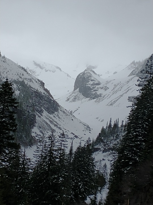
These photos are from years past and do not reflect current conditions. NPS Photo. View from trailhead for Carter Falls trail, looking across a snow covered Nisqually River channels to Eagle Peak. December 2018. NPS Photo. Upper end of Paradise River valley looking towards Sluiskin Falls with everything blanketed in snow. February, 2022. NPS Photo. View from Canyon Rim pull-out on road to Paradise of Nisqually River canyon to bottom of Nisqually Glacier. Upper Mount Rainier obscured by clouds. May, 2021.
30 notes
·
View notes
Text
Mount Rainier National Park is recruiting for 2-3 full-time interpretive volunteers, starting ASAP, to assist with visitor services this winter!
This is a full-time volunteer opportunity. Housing is included in the form of an apartment or room in a shared house. A uniform and any required training are also included.
Description
Successful applicant(s) will work a minimum of 32 hours per week (combined 32 hours if a couple) on the west side of the park. Start date is negotiable; assistance is needed ASAP but volunteers could start as late as January. End date is expected between April 10 and May 15, but that date is also negotiable. Weekend and holiday work are required.
Volunteers will primarily work at information desks inside the Longmire Museum (2,700 feet) and Henry M Jackson Visitor Center at Paradise (5,400 feet) providing orientation, information, and interpretive services to park visitors.
Between December and March, volunteers…
will serve as the lead and/or tail for public snowshoe programs.
will provide Preventative Search and Rescue ("PSAR," trail safety) information at Longmire and Paradise.
will assist with issuing winter recreation permits.
will provide PSAR information through phone, email, or in-person contacts.
will provide guidance for safe winter recreation, including options for hiking, winter camping, and snowshoeing.
will rove Longmire and Paradise areas to disseminate visitor safety information.
We are a fun group to work with! Come and enjoy/share this crown jewel of the NPS with visitors this Fall, Winter and Spring!
Successful completion of a federal investigative background check is required.
Contact: Curt Jacquot, West Area Interpreter,. Phone: 360-569-6577. email: [email protected] Mount Rainier National Park 55210 238th Ave East
Apply now on volunteer.gov
Note that Mount Rainier is also still recruiting for winter Emergency Roadside Assistance and Records Management as well.
19 notes
·
View notes
Text
The Ultimate Guide to Outdoor Adventure at Mount Rainier National Park Washington

by Paige Guscott
Discover the thrill of outdoor adventure at Mount Rainier National Park, Washington with our comprehensive guide. From hiking trails to breathtaking views, plan your ultimate escapade today! Join us now and embark on an unforgettable journey.....
Introduction
Welcome to Mount Rainier National Park Washington, a towering testament to nature's awe-inspiring beauty. Before we set foot on the trails or gaze up at the glacier-capped peaks, let's dive into the rich history of one of America's first national parks. Mount Rainier isn't merely a mountain; it's a place where past and present converge, inviting us to explore not just its landscapes but also its legacy.
IntroductionHistory of Mount Rainier National Park Washington
Establishment of Mount Rainier as a National Park
A Peak Like No Other
Elevation That Commands Respect
Volcanic Power Sleeping Beneath
A Refuge for Biodiversity
Human Footprints Across Time
Flora: A Tapestry of Plants
Fauna: Creatures Great and Small
Adrenaline-Pumping Activities
Hiking Trails for All Levels
Safety Measures and GuidelinesEncounters with Wildlife
Respect the Environment
The Rich History of Mount Rainier National Park Washington
Indigenous Communities and Preservation
Educational Opportunities for Visitors
Inside the Park: Historic Inns and Wilderness Camps
Near the Park: Cabins, Lodges, and Resorts
Camping and RV Sites
Backcountry Camping for the Adventurous
Permits, Camping Options, and Visitor Centers
Best Times to Visit and Weather Conditions
Hidden Gems within the Park
Learning More About Mount Rainier National Park
Contributing to Mount Rainier National Park
History of Mount Rainier National Park Washington
Photo by WikiImages on Pixabay
The story of Mount Rainier stretches back thousands of years, with its first human interactions traced to the Indigenous tribes who viewed the mountain as a spiritual icon. Known as "Tahoma" or "Tacoma" by the Indigenous peoples, this colossal stratovolcano has been a prominent landmark throughout the ages. European-American exploration began in the late 18th century, with the mountain being named after Rear Admiral Peter Rainier by Captain George Vancouver in 1792.
Establishment of Mount Rainier as a National Park
On March 2, 1899, President William McKinley signed legislation establishing Mount Rainier National Park Washington as America's fifth national park, putting it under the stewardship of the National Park Service. This pivotal moment marked the beginning of a concerted effort to preserve the mountain's ecosystems and cultural heritage. It was an acknowledgment of the park's extraordinary value, not only as a sanctuary for wildlife and flora but also as a source of inspiration and recreation for all those who visit.
As we embark on our journey through Mount Rainier National Park, these foundational stories lay the groundwork for all that we will experience. From the first bloom of spring wildflowers to the silent watch of ancient trees, every element here tells a part of Mount Rainier's enduring tale. So, let's lace up our boots, fill our lungs with crisp mountain air, and prepare to be captivated by the park's many wonders, both visible and those tucked away in the folds of history.
5 Facts About Mount Rainier
Carving a striking silhouette against the Washington skyline, Mount Rainier holds tales and truths as fascinating as its glaciers are deep. Following the rich history of this natural wonder, here are five intriguing facts that stand out about Mt Rainier:
A Peak Like No Other
Mount Rainier isn't just another mountain—it's the most glaciated peak in the contiguous United States, boasting 26 major glaciers that cover 35 square miles of its surface. These icy giants serve as the source for six major rivers, which in turn serve as foundational elements to the many different habitats located on and around the mountain. The Emmons Glacier, for example, is the largest single glacier by area, excluding ice fields, in the continental United States, and the Carbon Glacier lays claim to being the thickest and longest. This glacial grandeur not only shapes the side of the mountain but also supports a diverse ecosystem and supplies water to nearby communities.
Elevation That Commands Respect
Mount Rainier's summit stands proudly at an elevation of 14,411 feet, making it the highest mountain in Washington and the Cascade Range. This elevation doesn't just make for breathtaking views but also means that the weather can be unpredictable and severe. Even in summer, these heights can harbor cold temperatures and snowfall. Climbing to the summit is an adventure that requires preparation, respect for the mountain's power, and acknowledgement of its potential dangers.
Volcanic Power Sleeping Beneath
Beneath the serene snow-capped peak lies a giant slumbering volcano. Mount Rainier is part of the Pacific Ring of Fire and is considered one of the most dangerous volcanoes in the world, due to its large amount of glacial ice and proximity to metropolitan areas. If awakened, the lahars—volcanic mudflows—could pose significant risks.....
Read More...
Read the full article
0 notes
Text
Six Top Hiking Routes in Washington
Some individuals know that Washington State provides world-class hiking trails. The routes traverse diverse landscapes, including rugged coastline on the western border, arid high desert terrain in the eastern regions, and multiple mountain ranges in between.
The Skyline Trail, a primary hiking route in the Paradise hiking zone of Mount Rainier National Park, consists of a 5.5-mile path heavily enjoyed during the summer season and revered for its breathtaking vistas of Washington's iconic peak, Mount Ranier. Individuals can access the trail from the historic Paradise Inn parking area and winds through expansive subalpine meadows. Skyline Trail offers remarkable scenery and serves as the starting point for many adventurers aiming to summit Mount Rainier.
Next, the Cascade Pass Trail is one of the most accessible routes in the remote expanse of North Cascades National Park. Accessing the trail requires a 23-mile drive on Cascade River Road from Highway 20 near Marblemount. Recognized as one of the premier hikes in the region, it covers relatively easy terrain and offers stunning vistas of the rugged mountain peaks and the glaciated valleys below. The seven-mile round-trip involves navigating several switchbacks, gaining nearly 2,000 feet in elevation along the way. The Sahale Arm Trail suits advanced hikers and extends from the Cascade Pass Trail. It features additional panoramic views of subalpine meadows and majestic mountains.
Goat Rocks Crest Trail is a highlight along the Pacific Crest Trail (PCT) in Washington. Spanning approximately 28 miles with over 2,000 feet of elevation gain, the hike typically requires at least one night of camping. Hikers should prepare for varying weather conditions and expect to travel rugged terrain that winds along an exposed ridgeline dotted with large boulders. The route offers breathtaking views of iconic Cascade peaks like Mount Rainier, Mount Adams, and Mount St. Helens.
Hoh River Trail sits on the northwest side of Olympic National Park and showcases the diverse landscapes of the Olympic Peninsula in Western Washington. The national park boasts rugged coastlines, snow-capped peaks of the Olympic Mountains, and a captivating rainforest. Stretching over 17 miles, the trail maintains a relatively flat terrain, and its width accommodates summer crowds. Permits are available for camping along the trail for backpackers seeking an overnight stay. As the trail ends, hikers reach breathtaking vistas of Blue Glacier and Mount Olympus.
The Wallace Falls Trail in Wallace Falls State Park is one of Washington's most famous hiking routes. Just an hour from Seattle, the popularity of the hike stems from its accessibility and breathtaking scenery. The 5.6-mile round-trip trail passes by nine distinct waterfalls along the Wallace River. Hikers should prepare for intermittent slippery conditions, particularly when navigating the rushing waters. With an elevation gain of 1,300 feet, the trail's steepest climbs occur between the middle and upper falls.
Lastly, located in the eastern part of Washington State, the Steamboat Rock Trail near Electric City in Steamboat Rock State Park covers six miles in a loop and has an elevation gain of 700 feet. This trail sits 800 feet above Banks Lake, a sprawling reservoir spanning 600 acres. A moderate climb is necessary to ascend this route. During springtime hikes, wildflowers adorn the trail and offer panoramic vistas of the surrounding landscape.
1 note
·
View note
Text
100 Miles on the Wonderland Trail
Earlier this year, during spring 2022, I signed up for two lotteries that would grant me passes to backpack on either The Wonderland Trail or The Enchantments. The Enchantments is 21 miles. The Wonderland Trail is 100.
Guess which lottery I won?
Regardless of whether I thought I could do it or not, winning that lottery gave me no choice but to say yes. The park grants around 600 reservation-based permits every year.
It’s pretty intimidating to organize because you have to reserve all your campsites in advance, and it feels like waiting on your computer browser to register for the best classes you want. To my advantage and blessing, one of my best friends happens to be a map nerd—yup, they’re out there guys. They are out there and thriving! Thanks to his wisdom (and the handy dandy Nat Geo paper maps), after calculating the elevation and terrain of the land, he patiently sat with me on a Saturday morning in April, MONTHS before the start date, to help me pick out the best spots. And so, with five other people crazy enough to join me on this journey, we spent 9 days in August ditching our jobs, phones, and “real-world problems” to conquer 100 miles around the base of Mount Rainier.
We didn’t do any training beforehand. If anything, it was a chance to carb load as hard as we wanted because we knew that we were going to be eating nothing but dehydrated food and Clif Bars—so might as well enjoy what we had now! We even car camped the night before with friends who weren’t joining, destroying breakfast burritos and sipping on beers.
That being said, it was a late and ROUGH start on trail the next day. With unusually hot temperatures, we scaled nearly 2,000 feet of elevation at three in the afternoon, only to go straight back down at a knee-banging angle. Little did we know that that was going to be the pattern for every single day onward. Mosquitos were flying, sweat was compiling, and we didn’t get to our first campsite till after 9 p.m.
Several of us were definitely wondering what the heck we got ourselves into, but as the next couple days continued, we got our “trail legs” on. We learned to wake up before 7:30 and when it was time to go at our own paces. The heat subsided as we reached the northern side of the mountain, with wildflowers in full bloom and black bears grazing on days 3 and 4. The “wonderland” part of the Wonderland Trail began to settle in, and the further I wanted to escape within it. It became odd to hike on stretches of the trail that were open to the greater public of the park. We walked alongside day visitors covered in dirt with our giant backpacks while families and kids were prancing around with ice cold sodas and clothes that didn’t smell of crusty sweat and dust.
I couldn’t tell you how many running jokes came out of the trip, but I can tell you that I probably lost a couple pounds from how hard I laughed throughout The Wonderland Trail. I couldn’t begin to convey to you just how difficult the trail was, even after we had gotten into better shape. There’s 22,000 feet of elevation gain total, which left us with blisters and knee problems left and right. When I’d finally post up for the night (which is NOT right in front of a great view, for any non-backpackers reading this who see picturesque photos of campsites on social media), I’d knock out as soon as my head hit the pillow—and I’m a pretty light sleeper. Yet, despite all of this, I got to bond so deeply with our group, in a way that we will probably never get to do again. 9 days nonstop with the same people. Half of whom didn’t know each other super well prior to this trail. And yet, here we were by the end of it cracking stupid jokes, using the bathroom in front of each other, and just being plain gross together.
So by the time it got to day 7, when several of us were thinking about finishing the trail a day early, I wasn’t ready to leave. This year has probably been one of the most stressful and anxiety-ridden years of my life since 2015. My search for “the next move” in my career and my life begins to weigh on me harder as inflation continues to pressure everyone to do anything to stay afloat, and I’m constantly doubting what I’ve been doing to get where I am today. Being on this hiking trail, in the best shape I’d ever been by the end of it, without a phone whose emails are blowing up, and with some of the most genuine people I’ve ever met, I wasn’t ready to go back into all of that.
Yet, that’s what we ended up doing on the last day. And boy, did it feel good to sit in a car and drive it 10 miles at a quicker pace than it’d take to hike the same distance. We crawled to the McMenamin’s and ate our burgers and drank our beer, as is customary in post-hike culture. We drove home, and as the cold hardwood floors touched my feet, it felt foreign to stand on compared to the soft dirt of the trail. I avoided turning on my phone for hours, already aching at the thought of what might await me on the other end.
So here we are months later, and reflecting on the experience, I wonder why I only backpacked two trails this year. Life during/after/during-after covid has been so fast-paced, everything all at once. As I get older I realize how much harder it’s going to be to get to do things like this; just disappear for awhile, but with people I love.
I still don’t really know what the future holds, but for now I know that I’m capable of doing something as insane as this. And it may indeed continue to be hard to get out there as often as life continues to speed up, but I can’t wait until the next experience, and I will certainly do whatever I can to make sure I never lose those same feelings of escapism and gratitude when I get out there.
1 note
·
View note
Photo

Wonderland Trail | Day 1 | 9.4.19 Longmire to North Puyallup Camp | 19.3 miles I arrived at the ranger station around 7 a.m., and planned my nightly camps as I waited for the ranger station to open. Once my plan was set, and I had my permit, I was able to begin my hike. I planned on taking six days to hike the 94 miles around Mt. Rainier. The first day started out with a steep climb through heavily forested terrain, and a few creek crossings. I passed a few other groups of hikers and made my way along the trail. Eventually I climbed up high enough that I broke through tree line, and got a good view of Mt. Rainier and saw a couple of mountain goats as well when I reached a high lake where I took a break to eat some food and filter some more water. After my evening break, I made the descent to my first camp ground, where I had the group site all to myself. (at Mount Rainier National Park) https://www.instagram.com/p/B2XG6BLnaCo/?igshid=i7ugsnmj9w8f
30 notes
·
View notes
Photo
Wonderland Trail Day 2: I wake up and get moving before the sun is up after having been reminded yesterday how short the days are becoming (and how scary night hiking is - especially in Sasquatch territory). . There are flushing toilets at Cougar Rock Campground where I camped, but my body (unfortunately?) has never quite gotten onboard the poop-as-soon-as-you-wake-up train. However, my missed flushing-toilet opportunity turns out to be a blessing in disguise as by the time my body’s flipped switch number two, I find an outdoor box toilet (is that what we call these things?) - literally just a raised wooden platform with a toilet seat built into the top of it (see the second photo for details). When’s the last time you got to poop, sitting on what could essentially be described as a toilet, in the middle of the woods, in the rain, without pesky walls imposing their privacy on you? . Today was far more exciting than yesterday as I passed a bunch of vertical rivers (aka waterfalls), got above the tree line, and even got my first glimpses of Mount Rainier (aka the big mountain this entire trail is literally built around). . Despite my early-morning start, I still end up having to night hike. Why don’t I just stop before it gets dark and not complain about having to night hike? Because I don’t have a permit for camping in the backcountry and need to make it to a frontcountry campground to camp legally. That, and I don’t have enough food to extend this trip beyond my planned three days and so I can’t afford to extend this trip. . Day’s distance: 32.71 mi / 52.64 km Day’s elevation gain: 8,784 ft / 2,677 m Day: Cougar Rock Campground to White River Campground . #WonderlandTrail #Washignton
#mountains#getoutside#wonderlandtrail#washingtonstate#pnw#hikewashington#optoutside#halfwayanywhere#visitwashington#trekking#outdoors#trail#macinwashington#washingtonhiking#hike#washingtongram#backpacking#extremewalking#hiking#nationalpark#pacificnorthwest#choosemountains#naturelover#nature#mountrainiernationalpark#washignton#natureza#mountrainier
1 note
·
View note
Text
**Originally hiked: October 18, 2018**
Trail Data
Mileage: 9.9 miles Elevation Gain: 2,100 feet Location: Angeles National Forest Type: Out-and-back Difficulty: Moderate
What to Expect in this Guide
Aside from the road being closed to the trailhead we planned on doing, we ended up doing a tougher hike and a little bit longer.
As those of you know who usually read my posts, I have areas to which you can get a lot of more information about the hike we did. All in all, I put this area on here so that you can forward over to whichever area you would like to know more about.
Background – If you’re interested a little more about the area and some facts about the hike.
Map & Directions – See our hike on the map and directions on how to get to the trailhead below.
Weather – Definitely something you need to check before you go out on the trail.
Adventure Pass – Just a quick rundown of what pass you will need before you head out on the trail. *Pass is required to hike in this area.
Trail Camp & Water – The area has a trail camp with a water source nearby.
Maps, Books and Gear Recommendations – A great source for what maps or books to have before going out.
Hike Stats – I like to know points of interest on the trail, here are some for you to follow along when you go for the hike.
My Ramblings – This is my favorite part mostly because the pictures. Check this section out of my recollection of the hike and some photos.
Background
Mt. Hawkins sits in the Angeles National Forest (covering around 700,000 acres just outside of Los Angeles). Much of the trail from Islip Saddle up to Mt. Hawkins (8,850 ft.) is via the PCT (Pacific Crest Trail). Islip Saddle has a parking lot across the street from the trailhead.
Some nearby notable peaks that can be done in conjunction are Mount Islip, South Mount Hawkins, Middle Hawkins and Throop Peak. Have any of you done this hike with multiple peaks in the area? Let me know how in the comments below.
Map & Directions
To get to the trailhead:
Trailhead is at Islip Saddle, mile marker 64.1 on the Angeles Crest Highway. The drive is about an hour/an hour and a half away from the Los Angeles area. From downtown LA, take 110 North and merge onto I-5 North. About 7 miles later, take CA-2 N (Angeles Crest Highway) toward Glendale. Merge onto CA-2 E/I-210 E. In .4 miles take CA-2 toward La Canada Flintridge. Turn left onto Angeles Crest Hwy and drive 39.6 miles until you see a parking lot on the left at Islip Saddle. The trailhead is directly across the street.
Weather
Mt. Hawkins ~8,041 ft –> Weather.gov
Throop Peak ~ 9,138 ft –> mountain-forecast.com
Adventure Pass
There are no permits required to hike this trail.
To park your vehicle in this area, you will however need an Adventure Pass. To obtain an Adventure pass find the closest Forest Service location or go to any major sporting goods store. The fees are $5 per day or $30 annual. If you’d like to know more about the pass, read on the Forest Service Recreation Passes & Permits Website.
The Shell Station right off I-210 and CA-2 exit sells the Adventure Pass.
Trail Camp & Water
Little Jimmy Trail Camp/Little Jimmy Springs
Along this trail the only established trail camp is Little Jimmy Trail Camp. If you feel like an extra night in the area, Little Jimmy sits just 2 miles off Angeles Crest Highway. There are 16 established first-come, first-serve sites with fire rings. The campground includes vault toilets, backcountry ovens and bear boxes. The place is very popular with Boy Scout and Girl Scout troops, the two times I hiked in this area in the fall we passed by a few groups of scouts.
Angeles National Forest: Little Jimmy Trail Camp Information
Little Jimmy Springs is about a .2 miles walk away from the campground. The water usually runs year round and is super cold. This is a great spot to take a break quickly and fill up with water if you are running low on a longer hike. Always make sure you take enough water either way. We took about 3 liters of water each for 9 mile hike.
Maps, Books and Gear Recommendations
Topographic Map of Area: Trail Map Angeles High Country Map Book of Hikes in the Area: Trails of the Angeles: 100 Hikes in the San Gabriels
Gear Recommendations:
Obviously this isn’t everything I take on our hikes, check out What’s in My Backpack? for a compilation of some of the gear I have now. Some of the items I would recommend for this hike, especially colder weather:
Hiking Poles: BLACK DIAMOND Alpine Carbon Cork Trekking Poles
Headband: Adidas Woman’s Tech Headband
Fleece Gloves: Columbia Sportswear Women’s Thermarator Glove
Down Jacket: Patagonia Down Sweater
Wind Breaker: REI Co-op Rainier Rain Jacket
Some food we took on the hike:
Protein: Starkist Salmon Creations Lemon & Dill and Tuna Creations Thai Chili Style
Mayonnaise for our tuna and salmon packets: Hellmann’s Food Real-Vraie Mayonnaise – We bought a pack of 75 so that every time we go we can just pick a couple out from our hiking food bin
Soup: Lipton Soup Secrets – Chicken Noodle Soup Mix with Diced White Chicken Meat
Bars: CLIF Bar Chocolate Chip and Crunchy Peanut Butter
Bananas mmmmm
*FYI the salmon and tuna packets, Lipton soup, CLIF bars are all available at local supermarkets. I usually just buy on amazon in bulk since we go a lot and have hiking food bin. What do you keep in your hiking food bin?
Interested in gear and food ideas? See posts below for more.
[ihewc_oxi id=”20″]
Hike Stats
Trailhead 0 miles 6,800 feet Little Jimmy Trail Camp 2.1 miles 7,450 feet Little Jimmy Springs 2.3 miles 7,500 feet Windy Gap 2.4 miles 7,588 feet Mt. South Hawkins Turnoff 4.0 miles 8,390 feet Mt. Hawkins Turnoff 4.6 miles 8,730 feet Mt. Hawkins Summit 4.8 miles 8,850 feet
My Ramblings
I used to just write this portion of the blog, but decided since I do so much research why not create some guides of the information that I gather before I go out for these hikes. Should I put my ramblings and photos first or should I keep them here at the end? You guys let me know.
Alright, let’s move on and talk about this hike. My sister and I haven’t been on a hike alone in a while; we’ve been with groups, but alone I think our last hike together was Peanut Lake, back in 2016. Is that right? I think so. Either way I was blessed to have a hike together with my sister alone in our backyard mountains up in the San Gabriel’s.
We awoke early and left the house by 6:00am. We were not much more than 10 minutes into the drive when I had to turn around to pick up the water bladder (Osprey Hydraulics Reservoir – 3 L). If we were already to far into the drive we would have just picked up 3 L of water at the store nearby. This wasn’t the only thing we forgot on the hike, just wait for it.
Arriving to the Trailhead
After exiting I-210 road to Angeles Crest highway, I remember I left my annual Adventure Pass in my car back at home. So another thing I forgot, we stopped at the Shell station to pick a day pass up ($5.00). As we were driving to go do Mt. Baden-Powell from Dawson Saddle, we arrived at a Road that was closed at Islip Saddle. Not sure how we could have avoided not knowing, but they do post road closures on the county or forest websites. Plan B, open my Angeles High Country Trail Map and find a new hike.
There are a few options at Islip Saddle, so we geared up and decided to go hike Mt. Hawkins. I remember doing it a long time ago by myself, but thought it would be nice to check out the trail again with my sister and it was a little harder hike than we had planned, huge plus there we wanted a good workout. We started up the trail around 9:00am which would give us ample time to take our time up the mountain and hang out at the top.
The first mile or two was more vertical than the rest of the trail. We passed a lot of Boys & Girls Scout groups on our way up, probably stayed at Little Jimmy Trail Camp as it’s popular for the Scout groups to camp there on weekends. Little Jimmy Camp is only about 2 miles up the trail and the trail flattens out on this portion of the hike. We continued up towards Windy Gap making good time; Windy Gap sits at about 7,588 feet and offers 360 degree views of the surround mountains and valleys. Here there are a few options, you could turn back, head up to Mt. Islip, head towards Crystal Lake Campground or head on the Mt. Hawkins Ridge Trail to summit Mt. Hawkins or even further to Throop, Burnham and Baden-Powell.
Summiting Mt. Hawkins
Our choice was to hike up to Mt. Hawkins which would make for a 2,050 foot climb total; I liked the sound of that. 11:30am we reached the summit of Mt. Hawkins. We almost missed the turnoff; stay alert there is no sign for the turnoff to Mt. Hawkins. I’m glad I was taking note of the mileage on the Garmin. Did you know Mt. Hawkins is in the 11th highest peak in the San Gabriel’s? We didn’t make the top 10 list, but that’s ok it’s a peak above 8,000 feet very good training hike for the bigger mountains. I believe I just made a challenge for myself to knock off the top 10 in the San Gabriel’s. What those are I’ll probably post later as I already have the 10,000 Feet Peaks in Southern California Challenge ahead of me.
Had to put on some warmer clothes as we were going to hang out on Mt. Hawkins for a little. We wanted to make some soup and when I opened my bag I realized that I did not pack a fuel canister into my jetboil. I usually keep one in there but since our last trip to Havasupai Falls we flew, I took it out and never put a new one in when I got back home. Are you surprised yet? That’s 3 things and counting so far that were forgotten on this hike. Instead of a warm Lipton Soup Secrets we ended up having a couple mozzarella sticks and the Starkist Creations Lemon Dill and Thai Chili Style.
This slideshow requires JavaScript.
Down we went around 12:30pm so that we could hit the Newcomb’s Ranch for a snack before heading back home. We didn’t pass too many people on the way down except a couple who was doing one night up at Baden-Powell. About 1 mile from the trailhead my knee began to hurt, thanks to my sister who brought a brace I made it down in one piece. It looks like I forgot one other thing, that makes for 4 things we forgot on this hike. I should be wearing a brace every time I hike anyway so that will be added to my hiking checklist as a permanent item.
Reaching the Cars
It was about 2:30pm when we reached the cars and we changed quickly and headed down the mountain to go grab a quick bite to eat. Newcomb’s Ranch closes pretty early, so this is the first time I could actually sit inside and have a nice relaxing refreshing drink and a snack. Usually we get here as they are closing or already closed. My sister and I love these kinds of places; little gems hidden up in the mountains. Lots of motorcyclists like to end up here on their rides on the Angeles Crest Highway; we even saw some bicyclists who were brave enough to do that long ride in.
Well, I hope you enjoyed the write-up. What is the most common thing that you think most hikers (newbies or avid) forget on hikes? Let me know in the comments below. If you’ve done this hike before go ahead and comment below and let me know your experiences; I hope we can share more on here together.
Happy Adventures,
Annette – Beyond Limits on Foot
[related-posts-thumbnails]
[ap_instagram_slider]
Mt. Hawkins (8,850') in the Angeles National Forest. From Islip Saddle, 9.6 miles round trip, 2050' elevation gain. 11th highest peak in the San Gabriels. **Originally hiked: October 18, 2018** Trail Data
#Angeles National Forest#Hike#hiking#Mountains#mt. hawkins#National Forest#nature#optoutside#Outdoors#peaks#san gabriel#San Gabriel Mountains#Southern California#Wilderness
1 note
·
View note
Text
SpaceX's First Civilian Astronauts 'Underestimated' How Intense The Training Would Be
https://sciencespies.com/space/spacexs-first-civilian-astronauts-underestimated-how-intense-the-training-would-be/
SpaceX's First Civilian Astronauts 'Underestimated' How Intense The Training Would Be

SpaceX is about to attempt a new first: launching a spaceship full of people who aren’t professional astronauts into orbit.
The four-person crew consists of a billionaire, a physician assistant, an engineer, and a scientist. On Wednesday, weather permitting, they’ll climb aboard a Crew Dragon spaceship atop a Falcon 9 rocket, then roar into space.
They’re set to orbit Earth for three days, enjoying the views and collecting data for scientific research, then plummet back through the atmosphere and parachute to a safe landing. They call their mission Inspiration4.
Billionaire Jared Isaacman chartered the flight from SpaceX and is both footing the bill and commanding the Crew Dragon spaceship. He gave the other three seats to Hayley Arceneaux, who survived bone cancer as a child and now works at St. Jude Children’s Research Hospital; Chris Sembroski, an Air Force veteran who works for Lockheed Martin; and Dr. Sian Proctor, a geoscientist who serves as an analog astronaut in simulations of long-term Mars missions.
The crew isn’t just climbing into the spaceship like you or I might board a plane. They’ve spent the last four months training – studying manuals, pushing their bodies to new limits, and practicing for worst-case scenarios. They completed the training, which is largely based on NASA’s program, this week.
Even though Isaacman has spent thousands of hours flying jets and ex-military aircraft, he told Insider that the astronaut training was “more intense” than he expected.
“I definitely underestimated it to some extent,” he said.
When billionaires Jeff Bezos and Richard Branson each took their own rocket rides – flights which skimmed the edge of space but did not enter orbit – neither revealed the details of their training. But the Inspiration4 crew has been sharing its preparations publicly, offering a glimpse into what it takes to prepare amateurs for spaceflight.
Here’s what they’ve revealed.
Step one: Meet your rocket and watch it launch
Once the Inspiration4 crew was assembled, one of the first things they did together was watch SpaceX launch its third set of professional astronauts towards the International Space Station.
Arceneaux had never seen a rocket launch before.
“I thought I was gonna have anxiety before the launch, but it was actually really serene,” she told Axios reporter Miriam Kramer for the podcast “How It Happened.”
The soon-to-be spacefarers used a centrifuge to simulate the feeling of launch
Chris Sembroski sits in a SpaceX centrifuge chamber. (Inspiration4/John Kraus)
A centrifuge spins really fast to create centrifugal force that pushes things outwards, much like a salad spinner or the spinning carnival ride that presses you against a wall. That force mimics the feeling of launch, when the pull of gravity on your body feels three times its normal strength. Many astronauts and pilots use centrifuges in their training.
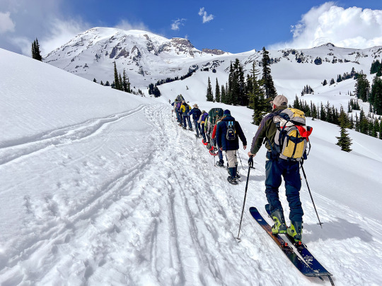
Isaacman took his teammates up Mount Rainier
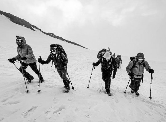
The Inspiration4 crew climbs Mount Rainier. (Inspiration4/Scott Poteet)
Washington’s Mount Rainier is a 14,410-foot active volcano covered in glaciers, with punishing weather and hazardous crevasses. Summiting requires ice axes and crampons. So Isaacman decided it would be the perfect place to break the ice with his new crewmates. They climbed the mountain together in early May.
“They built some mental toughness. They got comfortable being uncomfortable, which is pretty important,” Isaacman said. “Food sucks on the mountain. Temperatures can suck on the mountain. Well, that’s no different than Dragon. We don’t get to dial up and down the thermostat … And I can tell you the food isn’t great in space, from what we’ve tasted so far.”
After camping, it was time to hit the books
After Mount Rainier, the crew flew to SpaceX’s headquarters in Hawthorne, California to begin training in earnest.
“Every day was pretty much a 12-hour day, and then you were getting back to the hotel room, and you’re just studying. That was kind of the intense academic portion of the training,” Isaacman said.
They had to learn about the parts of the Falcon 9 rocket and Crew Dragon spaceship, how everything works, and what can go wrong.
“We have like 3,000 pages across 100 different manuals. It was a lot. I don’t think any of us really predicted that,” Isaacman said.
Then the crew practiced flying Crew Dragon in simulations

Sian Proctor on a visit to Space Camp in Huntsville, Alabama. (Inspiration4/John Kraus)
Inside a mock Crew Dragon model, the Inspiration4 passengers practiced the procedure for launches and landings. Once they got used to how things are supposed to work when all goes smoothly, trainers started adding issues and spacecraft malfunctions to the simulation.
Some of these exercises involved all four crew members, but some were just for Isaacman and Proctor – the commander and pilot of the mission. Eventually, they were doing full simulations with mission control and a launch director.
In early August, the crew did a grueling 30-hour simulation
Isaacman, Proctor, Arceneaux, and Sembroski put on their spacesuits, climbed in the simulation model of the Crew Dragon, and sealed themselves inside for the 30-hour ordeal. Nobody knew what was coming, not even the mission controllers. A simulation supervisor had pre-programmed everything.
They practiced a regular launch, with a weather delay included. They ate a meal and slept. But as their simulated mission began to reenter the atmosphere and fall back to Earth, all hell broke loose.
The Axios podcast recounts what happened. In the simulation, as the Crew Dragon pushed itself into Earth’s atmosphere, three computers failed. The crew lost touch with mission control. Then the capsule’s parachutes wouldn’t deploy.
“Now you’re blind, you can’t talk, and there’s no way for the chutes to come out. There’s also no way for Dragon to stabilize itself during essentially a hypersonic reentry,” Isaacman told Kramer.
When they got their bearings, the crew realized the simulation was sending their hypothetical capsule a continent away from its intended splashdown site.
“It felt very real. You’re living in it for 30 hours. The last 45 minutes, there was awareness from us in the capsule, and them on the ground, that there is a chance that this might not be actually a survivable situation,” Isaacman told Kramer.
In the end, they landed safely, but the podcast did not specify how the crew pulled it off.
The training also involved fun parabolic flights to simulate microgravity
In a parabolic flight, a plane flies in arcs up and down, creating up to 30 seconds of weightlessness at the peak of the arc. Some people call the planes “vomit comets.”
The team tested their bodies in a high-altitude chamber
It’s rare, but sometimes spaceship cabins become depressurized, just like an airplane cabin. Spaceships typically have oxygen masks on board in case this happens. But it’s still helpful to know how your body will react before you slip that mask on. Being familiar with the symptoms of oxygen deprivation can also alert crew members to a cabin leak if the spaceship’s systems don’t detect it first.
To experience those symptoms firsthand, under supervision, the crew took to an altitude chamber that exposed them to a low-oxygen environment.
“It provided great insight into each of our various symptoms,” Arceneaux said, according to a tweet from the mission’s account.
They’ve learned to draw blood and take skin samples
Since scientists want more information on how spaceflight affects the body, the Inspiration4 crew offered to gather biological data for NASA. In addition to taking each other’s blood and skin samples, the crew will monitor their sleep, take daily cognitive tests on an iPad, and scan their organs with an ultrasound device. Isaacman said they didn’t realize quite how extensive this research would be.
“We were like, maybe we should have talked about this before we did it,” he said.
He added that the crew members will have to take skin-cell swabs “three times a day on 10 different parts of our body.”
The crew squeezed in some jet piloting above SpaceX’s facilities in Texas
During their training period, the crew members made public appearances, did media interviews, and took trips to Space Camp and SpaceX’s rocket-development facilities in Boca Chica, Texas.
That latter site, which SpaceX founder Elon Musk calls “Starbase,” is where the company is building and testing prototypes of its Starship mega-rocket and Super Heavy booster. When they visited, the Inspiration4 crew members went for a plane ride high above the rockets.
Earlier in the summer, Isaacman and Proctor also did fighter-jet training in Montana to brush up on their piloting skills. NASA astronauts do the same to practice thinking and responding quickly under stress.

The Inspiration4 crew flies jets above SpaceX’s facilities in Boca Chica, Texas. (Inspiration4/John Kraus)
With their training is complete, Isaacman, Proctor, Arceneaux, and Sembroski flew to NASA’s Kennedy Space Center in Florida on Thursday to complete the final preparations for launch.
They are SpaceX’s first commercial passengers, but the company aims to fly more. It already has another such mission lined up in January: For that flight, called AX-1, the company Axiom Space chartered a Crew Dragon to take customers to the International Space Station for eight days.
The AX-1 crew includes real-estate investor Larry Connor, Canadian investor Mark Pathy, and former Israeli fighter pilot Eytan Stibbe. Axiom Space’s vice president, former NASA astronaut Michael López-Alegría, will command the mission. It’s not yet clear what their training regimen will be.
This article was originally published by Business Insider.
More from Business Insider:
#Space
0 notes
Text
Have you ever hiked somewhere in the summer or fall and thought, “this would be a great place for snow camping?”

Well, have we got a deal for you. Snow camping is still open in the higher elevations of the park, places like Reflection Lake or Mazama Ridge.
You’ll need a free backcountry permit that you can pick up from a ranger at the Longmire Museum on weekdays or Jackson Visitor Center on weekends. The rangers can help you figure out what spot might be good for you to snowshoe or ski to. Make sure you have ways to protect your food and food-smelling items safe from wildlife. And then, with all your gear prepped, it’s time to head out.
You can camp in one of these wonderful places and have it all to yourself. Reflection Lake to yourself? Doesn’t that sound amazing?
Snow camping closes when the snow is too shallow to protect plants or until May 15, whichever comes first.
Great information can be found online at https://www.nps.gov/mora/planyourvisit/winter-camping.htm
We hope you have a great time enjoying the snowy solitude of the park.
These photos are from years past and do not reflect current conditions. NPS Photo. Looking up a skinny dirt trail on Mazama Ridge through an autumnal meadow to evergreen trees and then Mount Rainier. October 2014. NPS Photo. View of snow covered trees and meadows of Paradise River Valley and Mazama Ridge beyond. February 2022.
24 notes
·
View notes
Photo
By Michael Lanza
“There’s absolutely no one out here.”
I was just a few hours into a solo backpacking trip around Mount Rainier National Park’s 32.8-mile Northern Loop when that realization hit me. It was a cool, clear day in October 2003. None of my usual hiking partners had been available to join me. So I decided to do the trip alone, something I’ve done more times than I could count and felt comfortable with. I had no idea that this time I’d face the kind of situation that solo hikers think about but can never anticipate: a threat that shrinks the margin of safety in the wilderness down to nothing.
When I picked up my backcountry permit that morning, a ranger told me a snowstorm had hit the park just two days earlier. “You’ll probably run into at least a foot of snow on the ground at higher elevations,” he said. That didn’t dissuade me; I was prepared for snow. Neither of us, however, knew about the much bigger storm brewing out over the Pacific Ocean as we spoke, collecting moisture as it barreled toward the Cascade Range.
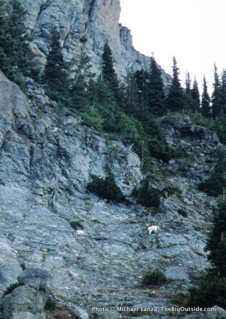
Mountain goats on Yellowstone Cliffs, along the Northern Loop in Mount Rainier National Park.
That conversation came back to me as I walked past the rippling water of a tiny tarn in a meadow on my way to Windy Gap. Just a few tiny patches of white remained on the ground at 5,600 feet. Sun and mild temperatures had evaporated the recent snow. But apparently no one had been out there since the storm, because even the rangers had no idea what trail conditions were like.
That’s when it hit me: With backcountry rangers warning anyone considering a trip that they would encounter deep snow, I would probably not see another person out there.
Autumn can be the finest time to head into the backcountry. The foliage changes color, brightening the landscape. There are no bugs. The weather often achieves something close to meteorological perfection: skies clear and dry, affording hundred-mile views, and temperatures not too hot during the day, not too cold at night. I’ve enjoyed some of my best days in the mountains in the fall.
But autumn exhibits a bipolar personality. And in October, you are as close to the mountain winter as you are to its summer. In some respects, it is more dangerous than winter because in fall it’s easy to get lulled into trusting the weather. But really good can turn really bad, really fast.
Looking back, I think that most if not all of my hardest, most wretched experiences in the backcountry have occurred between the autumnal equinox and the winter solstice. On Mt. Rainier National Park’s Northern Loop, I was about to add another to my list.
Hi, I’m Michael Lanza, creator of The Big Outside, which has made several top outdoors blog lists. Click here to sign up for my FREE email newsletter. Subscribe now to get full access to all of my blog’s stories. Click here to learn how I can help you plan your next trip. Please follow my adventures on Facebook, Twitter, Instagram, and Youtube.
Approaching Windy Gap on the Northern Loop in Mount Rainier National Park.
That first afternoon, I watched two mountain goats step nimbly across the crumbling face of Yellowstone Cliffs. Then, perhaps inspired by them, I scrambled off-trail from the little, unnamed tarn just before Windy Gap up a talus slope to the saddle between Crescent Mountain and Sluiskin Mountain. There, under a mostly clear sky, forested hills sculpted by ancient volcanic activity undulated away from me to the always improbably enormous, white mass of Mount Rainier (see lead photo at top of story).
Three of the biggest glaciers on “The Mountain,” as western Washingtonians affectionately call Rainier, pour off the northerly aspects I saw from that overlook: the Emmons, Winthrop, and Carbon. On my third day out there, I would walk past the toe of the Carbon, the lowest river of ice in the contiguous United States.
That night, I found myself cocooned in extremes of quiet and darkness, camped below giant firs, pines, and cedars. I could hear only the wind’s occasional perambulations through the treetops, and sank into a sleep as deep as the surrounding silence and blackness.
Click here for The Big Outside Trip Planner: Backpacking Mount Rainier’s Northern Loop
Reading the trip planner requires a paid subscription. Not a subscriber yet? Click here now to subscribe and get full access to all stories at this blog for as little as five bucks for a month, or just pennies over $4/month for a full year.
Lake James along the Northern Loop.
My second morning brought partly cloudy skies—nothing to suggest what was headed my way. I packed up early and headed downhill through cool forest, crossed the silt-gray West Fork of the White River on a log footbridge, then made a 2,500-foot climb up onto a plateau. The meadows of Grand Park sprawled out more than a mile across. A little while later, I reached the cirque of Berkeley Park, where dense copses of conifers mingle with fields of grasses and wildflowers. Though it was long past wildflower season, Berkeley’s rich hues of green give the impression of a meticulously landscaped park.
By afternoon, I was following the Wonderland Trail west across more high meadows. Rainier migrated in and out of clouds, but patches of blue sky let the sun through periodically. The scale of everything felt magnified by a powerful sense of solitude: On one of the country’s most famous backpacking trails, I saw not another human.
But more than that, by that point I had no expectation of seeing anyone else; and once you’ve crossed that mental threshold, you see your world differently. Instead of chatting with a hiking partner or wondering how many backpackers will be sharing the next camp, you are keenly tuned in to every nearby movement or noise, every change in the play of light or shift in the air temperature and wind. It’s not fear so much as a hyper-awareness that we rarely find in everyday life, as if a third eye suddenly sprouted on the back of your head.
Even in the wilderness of many national parks, seeing absolutely no one for days—conjuring a sense of this country’s wild edge before Western settlement—is a rare experience. Most parks, Rainier included, are popular enough that backcountry permit numbers are restricted, both to prevent resource overuse and to preserve some sense of solitude. But that only regulates the numbers of backpackers, of course, not dayhikers. While the number of people you encounter generally corresponds to factors like proximity to major population centers (Rainier’s Nisqually entrance is 85 miles from Seattle) and a trail’s difficulty and distance from the nearest road, during the peak hiking season, you usually cannot walk very far without running into other people.
The Northern Loop of Mount Rainier National Park is a sort of miniature version of the Wonderland Trail, the 93-mile-long footpath encircling Rainier that draws backpackers from all over the planet. The Northern Loop delivers the same Wonderland-esque experience of hiking from temperature rainforest to sub-alpine meadows bursting with wildflowers—in fact, the loop overlaps with a stretch of the WT. But because it’s not nearly as well known, getting a permit for it does not involve the level of competition that you’ll face trying to plan a summer trip on the Wonderland.
By the time I pitched my tent at the Mystic backcountry camp on my second evening, I felt like I’d hit the trifecta. For two clear, crisp autumn days I had basked in complete solitude with jaw-unhinging views of The Mountain and its meadows.
Then the rain came.
Plan your next great backpacking trip in Yosemite, Grand Teton, or other parks using my expert e-guides.
Above the West Fork White River along the Northern Loop in Mount Rainier National Park.
Throughout that second night, wind and water lashed at my shivering tent. In the morning, I ate breakfast inside my cool, damp little nylon shelter, packed up as quickly as I could as rain drummed onto me, and set out in conditions approximating a category one hurricane.
I’ve plodded down trails through biblical-scale rains from New Zealand to Vermont’s Long Trail. On the latter, I was attempting a thru-hike—also in an October several years before this Rainier trip, also solo (yes, I’m a patient learner)—but aborted it after two weeks and 10 inches of rain, heading home with waterlogged boots and spirits.
But I’m not sure I’ve ever seen rain like I saw that day on the north side of Rainier. The unrelenting downpour was punctuated by wind-borne sheets of water that hit me as if hurled from a barrel. Miserable as it was, though, it was hard to not feel awed. Following the Wonderland Trail around the shore of Mystic Lake, I watched the bizarre phenomenon of atmosphere impersonating ocean as visible waves of water rolled one after another through the air above the choppy lake surface. The rain fell torrentially and without pause; I could often see no more than one or two hundred feet before everything bled into a blank wall of battleship gray. Midday was as dim as dusk.
It became clear that I needed to get back to my car as quickly as possible that day—not just because the trip had ceased being fun, but for my own safety. I crossed a rain-slicked log bridge over a creek so bloated that its white teeth gnashed at the 10-inch-wide platform beneath my boots. Had I arrived there an hour later, the bridge might have been gone.
I hurried the miles to my car, anxious to be dry—but not fully aware of the urgency of escaping quickly.
I can help you plan the best backpacking, hiking, or family adventure of your life. Find out more here.
Berkeley Park along the Northern Loop.
That October 2003 tempest would become the second of four storms within just 12 years to cause 100-year or bigger floods in the Pacific Northwest, from Mount Rainier to the North Cascades and the Olympic Peninsula. Scientists now know that the warming climate is incubating larger, more destructive storms—in part simply because air can hold more moisture as it warms.
The third storm in that series, in November 2006, dropped nearly 18 inches of rain in 36 hours—the equivalent of getting 15 feet of snow. It triggered record floods in Mount Rainier National Park—destroying roads and trails, burying one backcountry campground beneath a massive lahar, or debris flow (no one was there at the time), washing away at least two dozen log bridges over creeks along the Wonderland Trail, and closing the park to motor vehicles for an unprecedented six months.
That 2006 storm would also swell the Carbon River sufficiently to erase a huge swath of the trail I was hiking on my last day on the Northern Loop, and the road I would drive out to civilization. (The trail was repaired; the road no longer exists.) It’s not hyperbolic to say that, had the 2003 storm begun a little earlier or stalled a little longer over the region, I might have ended up as the subject of the kind of brief accident report that parks issue now and then, which dryly explain that no trace of the missing person was ever found.
Click here for The Big Outside Trip Planner: Backpacking Mount Rainier’s Northern Loop
Reading the trip planner requires a paid subscription. Not a subscriber yet? Click here now to subscribe and get full access to all stories at this blog for as little as five bucks for a month, or just pennies over $4/month for a full year.
None of that transpired, of course. I made it safely to my car and drove out of the park, happy to be dry, warm, and safe. I told my wife what happened, but otherwise, almost no one knew how close I came to being a grim statistic.
Absolute solitude in the wilderness is a precious stone that should always be handled with care. It sometimes arrives gift-wrapped in circumstances magical and enlightening, or challenging far beyond what you expected—or both in the same trip.
And sometimes what transpires is mostly just a matter of timing and luck.
Tell me what you think.
I spent a lot of time writing this story, so if you enjoyed it, please consider giving it a share using one of the buttons below, and leave a comment or question at the bottom of this story. I’d really appreciate it.
NOTE: I write more about Mount Rainier National Park’s climate-change story in my book, Before They’re Gone–A Family’s Year-Long Quest to Explore America’s Most Endangered National Parks, from Beacon Press. See also my story about a three-day family backpacking trip in the park, “Wildflowers, Waterfalls, and Slugs at Mount Rainier.”
You live for the outdoors. The Big Outside helps you get out there. Subscribe now and a get free e-guide!
0 notes
Photo

The solitary that can be found while wilderness camping is pretty remarkable and vastly different from campgrounds. You might need a permit depending on where you go, but you’ll definitely need considerable respect for the land and wildlife in order to preserve these gorgeous areas. Please, please, please treat these places with extra special care and love (not unlike how you would treat a very kind host) while they welcome you in for a lovely stay. 💚🏕🗻💚 (at Mount Rainier National Park) https://www.instagram.com/p/BwC56fwhFu9/?utm_source=ig_tumblr_share&igshid=1qct6ocpywpb0
0 notes
Text
the fleet's commander In chief marine. .... Page 10, Register-Guard, Eugene, Ore., Wed., June 25, 1947 Ex-Marine Turns Down Plot said, one carrier, two . cruisers, eight destroyers and about five BMt "rfl Won in Gl Land Lottery Senate Action Keeps Pacific Fleet Intact HONOLULU W Adm. Louis E. Denfeld said Wednesday that Senate restoration of 157,000,000 tentatively slashed from the Navy budget by the House of Representatives will permit the fleet to maintain a nearly normal force In the Pacific. Had the House cut gone through, Moufain States Extends Springfield WalerSystem mount up too high for him to pay, LA GRANDE. Ore. IU.PJ 2 Uillion Feet USTT FOR Aic he said. Object to Cost Observing there were no buildings of any sort on the land, Haefer said that despite all this: from Tenth St. to Thirteenth St. using eight inch pipe; J St. from Tenth St. to Twelfth St using six "Even considering the present condition of the tract and its un inch pipe. SPRINGFIELD The Mountain .-States Power Co. is in the process of laying over 11,000 feet of water mains here and expects to have the projects scheduled completed within another month according to Burt Albers, water superintendent for the company. MEDIATE DEUVEB, DOORS - WINDOWS L PlWivIT' W ,s. pee im vm&kSgrgf HENRY BACON to? CAMP ADAIR, OREGON piJV : j Tenth St. from K .St, to M St., four inch pipe; Eleventh St. from Garden Tractors FOR RENT 1668 Willamette Phone 92 K St. to N St., four inch pipe; Twelfth St. from K St. to N St. four inch pipe; Eighth St from K Carson Haefer, 26-year-old for-mer U. S. Marine from Cove, Ore., said Wednesday that as far as he is concerned tl.j government can take the Roza, Wash., farm he won in a veterans' homestead drawing and use it for a coyote pasture. Haefer was one of 28 former GI's who recently won tracts in the Roza project in the Yakima Valley of southern Washington. He said he would not take the land because of conditions attached to its acceptance, including the high cost of developing what he described as' a patch of barren desert. His Investigation t his 78-aere grant, said Haefer, showed that approximately S35.000 would have to be spent before the lapd could be lived upon and put into production. The former Marine estimated St. to Q St., four inch pipes. AI.lt Iw- Four additional fire hydrants are being installed around the -- Union High School to make a complete loop around the school area and thus give fire protection on A main from the reservoir on Willamette Heights to Third and known potential production value, I would go ahead if it weren't for the $265 an acre construction cost." . The veteran said he had talked with other GI's who had won land parcels in the drawing, and "none of us had heard of the charges on the tracts beforehand." "I could sell the land after working it for the period of my overseas service about 13 months. . But," he concluded, "I dont's think there is anyone stupid enough to buy that tract for $263 an acre." - Sts. has been completed. all sides of the $500,000 plant. It is anticipated that several short water main extensions will be installed possibly later in the year. However, Albers said this Other water mains scheduled and partially under construction are: extension of line on K St would depend on the availability or additional pipe. . rzz THIEF REPENTS SALEM m Eight months ago an $185 trapgun was stolen from the Salem Hardware Co. Tuesday the gun was returned by that it would take $20,000 for construction costs alone on his 78 acres, what with the government charging $265 an acre for building HAS I GRANDPARENTS SOUTH BELOIT, 111. U. Stephanie Ray, .infant daughter of Mr. and Mrs. Raymond Olds, has 10 living grandparents, including six in the "great" class. Cameras With Cases REUIRE 8mm. ....$l.0 REVERE 8mm. Mas;. Load. .137.50 AKGC3 C- r 78.33 and irrigation facilities. "There isn't any drinking mail, without ever having been used. : .. FRANK FIELD TILE CO. Everything in tile. Phone 1364-J. water," Haefer said, "and drilling a well would cost about $2600." The sagebrush - covered area S Phone 535 Seventh cV yttthtSiaitef thtJSUfXotSdi' EUGENE, ORE. would have to be cleared and JOCKEY-. Model Janice Cooper, (above) in costume appropriate to her selection as Monmo-jth Park race track's "jockey girl," will present awards .to winners of special events levelled at a cost of another $20 an acre, he noted. And other1 needed expenses, including instal 1 I ft M nADio. HI DADIO lation of electric power, would EUGENE PLANING MILL WILL BE CLOSED FOR VACATIONS JUNE 28 TO JULY 7 So you couldn't force yourself Into a container of that size. So what? You can gtt just as good "snaps" as Snapper gets by making our store your Film Headquarters. Ik 1 JrL m llEPAISUKS ON AH MAKH Unmarried Couple Confess VTA Desertion of Little 'Miss X' 73 1(7 I. Ilth. J) GRANTS PASS M") The;Tenn., and was living with' Mrs. mystery of little "Miss X," the Meddlin, the sergeant continued. mm irwB'r.MC Wr r-'l ilexi toJflayflcuierlktadt abandoned girl found in Weed,! Gilreath at first denied know! In which we explore Indian Country with Chevron Supreme Calif. June 15, was solved Wednes 15" 3HBT edge of the child, but later admitted, leaving her at Weed De-cause at home "there were too many kids around," the sergeant said. day, state police said, by the confessions of an unmarried couple who decided they had "too many kids around." They identified the badly beaten girl eyes blackened, body bruised and left arm temporarily useless when found in a clump of bushes This ploturmw Sotittwwl ,s ere of th. Wl-Mlor Sunk Viswi bttlnsd whtrtvsr yMt Chevron Supr.ms DO YOUR WASHING at COX'S SELF-SERVICE LAUNDRY as Mary Jane Meddlin, 2V4, Selma, Ore. Mother Confesses - Sgt. C. R. Borgman of the state AT LAST 9 Tube PHILCO Table Model RADIO FM Short Wave-Standard Broadcast $157.95 Oldfield's Electric Ph. 254 846 Olive police said she was a daughter of II Mrs. Lucille Meddlin, Selma. who Complete Laundry Facilities and Fountain Lunch! signed a confession that with Hugh Gilreath, 25, sawmill worker, she beat the child severely June 14, II ATS CLEANED AND REBLOCEED $1.00 O.K. HAT SHOP 1434 WILLAMETTE one nignt Deiore entering the no No Appointment Necessary 2nd & Polk St, Ph. 2034 pital here as Mrs. Lucille Gilreath" to have her third baby. The woman was separated from her BBBBtl -J husband, Borgman said. The sergeant said California au thorities have served a warrant charging assault with intent to kill on Gilreath and that the sawmill worker had waived extradition, Denies Beating Borgman added that Gilreath signed a confession that he took the girl to Weed by bus une 15 THIS IS INDIAN COUKTRT LAND OF GHOSTS AND PBANKJffl . NATURg- I Monument Vail. hre forgotten wateni4 patient winds have carredj :; symphonies in stone, I; sketched this Navajo wbmaai , woa,Tihg a blanjtt te'colbf ful as the country. It's lonesome, ahd off this ni' ,' way, but good driving f itt "clinate'-tailered" Chevren -Supreme Gasoline in the taj. and abandoned her there, but said unreath denied ever beatine the tot severely. He also denied that the girl was "criminally mishan died" as Deputy Sheriff Dan Bennett, Weed, reported, Borgman said, The police announcement ap parently ended a ten-day search that had extended the length of the .Pacific Coast. Unconscious when first found, the eirl later later was unwilling or unable to give authorities her name. Police had then investigated scores of reports of missing children and "suspicious-looking" men. One such report paid off, Borgman said. It lead to Gilreath. who came here last year from Jellicot, Plywood Log Coronado. searehihg for the seven cities of Cibola, probably marvelled at these 40-fbot desert giants. Elf owls and woodpeckers nest in the saguaro oactus. delioate flowers tip their tortured branches in the Spring. Savinq Urged PORTLAND M Northwest plywood producers were told Wednesday their supply o peeler logs can't be assured unless they conserve second growth timber. The warning came from Dr. J. A. Hall, director of the forest service's northwest experiment station, In his annual report. 1 4 ' 58 West 11th Ave. J Dr. Hall said that cutting, most of it in second growth, had been destructive. Most peeler logs are ..iltiu (if TftlBLa. ... rM,rn nan ai w heating up unm n --' was taken from trees 45 to 60 years old. Thus is lost about 1200 board feet a year per acre, he said. Trees should be allowed to mature, he insisted. n fan belt. Hit I ,t - ever Oeasfledl Trading Post put m a here, but no vapor-x Another conservation practice would be the pruning of young trees to eliminate knots. to Chevron Supreme P"Bi "uions tailored to suit Woal driving conditions ia each temperature zone. We Are Saving Others Money, Why Not You? See ui U you are planning CEMENT WORK REMODELING NEW CONSTRUCTION Lou Germain Contractor 307 Hampton Bidg. Ph. 129 ARMT SUPPLIES Ollkey Trading- Post, 1873 Franklin at 13th Ph. 5918-W. Curtains cleaned In Sanltene Electrlo Cleaners, 1210 Willamette St. This ancient, colorful land is full 6f surprising thingsto see. I enjoyed every mile 6f it... and some of the sredit belongs to Chevron Supreme. For though the mountains are high, s is Chevron Supreme 's octane rating, and X didn't hear a ping on the trip.. We Will Close For Vacations ONE WEEK JUNE 30th TO JULY 5th GOOD MILLWORK 3 Prove to yourself what thousands are discovering ' daily: that dry beer is more refreshing. Try ' Rainier Extra Dry, the beer with the clean, crjsp i , flavor and bouquet, and the golden, true-beer color. ' k C72) Its good going on p x e- "ev since mi EXTRA DRV RPPn Midgley Planing Mill Co. SUPREME GASOLINE Rainier Brewing Company San Francisco Let Angeles llll - .-i . ' ''y '"'VJt j 4th and High Stt, Phone 1059 i
1 note
·
View note
Text
My 6 Day Adventure Hiking The Wonderland Trail-Day 1
My 6 Day Adventure Hiking The Wonderland Trail-Day 1
And We’re Off!
Waking up with the sunrise, we broke camp and climbed up the Wonderland Trail towards Granite Creek. Our first steps were in the cool shadows and the ridge lines with lingering snow brightened by the sun. Lavender lupine lined the trail as we moved into sections with more vegetation.
We had 15.3 miles to cover today to our camp at Cataract Valley. Passing under the Burroughs…
View On WordPress
0 notes
Link
While all of our volunteers have mad skills they share with us in every project (I see you master rock placer), we use the term “Skilled Volunteers” to refer to volunteers who donate their professional skills to specialized projects here at the park. Currently we have skilled volunteers working in our radio shop, with our biological scientists, and monitors for the park’s sustainability efforts and energy usage. In 2016 four students at the University of Washington partnered with the park to develop the online permit system for summer camping permits. While the product of this project had some challenges and has since been replaced, this partnership help jump start the revision of the park’s wilderness permit system, and was a hands on learning opportunity for the students involved. To learn more about the project check out this article from the Washington Trails Association.
0 notes
Text
Five Wonderful Walks For Little Ones At Mount Rainier National Forest.
Fall vegetation beautiful drives in New Hampshire are plentiful covering Pond Winnipesaukee, Connecticut River and a number from trips throughout the White Mountain location. The climb to this quick and also very easy route begins at Johns Mountain range reaching the last ignore from Keown Falls. Yes, Virginia, in 2016 formerly bankrupt charcoal providers continuously blow up out historic Charcoal Stream Mountain and also nearby communities.
I discussed that it was a couple of my friend's first time in the White Mountains and also she has currently been actually attacking me up to going in again. Know as well as practice your skill-sets prior to you get along the hill (off your layering unit to getting through in whiteouts to crevasse saving).
Along with an elevation of 5,109 m this is actually the greatest hill in both the DRC and Uganda and also the 3rd best mountain on the continent after Mount Kenya as well as Mt Kilimanjaro. One theory assumed that the creature was a panther or even cougar, due to the radiant eyes.
Yes, the aspect you make holds, however I experienced the have to comment because typically this seems like white colored Europeans are criticized (and also blame themselves) for the entire slave labor when in genuine truth they were actually merely participating a currently effectively established trade.
. However global requirement is climbing a lot faster, driven by demand well-maintained electricity and also clean automobiles, leading to projections from a 40,000-tonne annual shortage through 2015. Below you may find a nice little camping area that gives a pool and also well-maintained downpours for a reasonable cost and also you have the incredible viewpoint in the direction of the ruins of the Arco towering over the city.
In addition, Eco-friendly Mountain Coffee has debuted a brand-new Boskiecialo.Info as well as small 12-count carton of K-CupsR, offered in ten various wide arrays from coffee, consisting of Multilateral trade CertifiedTM as well as all natural offerings. When this occurs you have increased possibilities of leaks, bugs, scum and algae development, as well as filthy water escape when you drive someplace.
This little island possesses windy roadways, surrounded by olive groves as well as mountain sights that are to die for. A first chance to the torso may or could not sympathetically get rid of the dealing with Mountain Lion. This mountain claims lives annually as disorders around may wear away greatly within moments.
I could not agree with him more as well as applaud him as well as other ahead believing execs that are actually operating to promote for a cost on carbon - which I feel will certainly transform the globe our company reside in - as well as permit our team to prosperously tidy up our environment.
White water rafting additionally functions as a dependable stress buster and also a welcome rest from the monotony of each day everyday life. Noguchi has actually led a number of similar trips to Mount Everest previously, accumulating a total amount from 8.8 tonnes of rubbish coming from each sides of the mountain range.
With handful of exceptions, all of our indoor wall structures will certainly coincide version from white colored as well as the slick will definitely be actually a less matte model of the very same white colored. That is actually perfectly legitimate for him to value his C.F. Hill guitar over a C.F. Martin guitar - as long as he certainly never aims to market that to somebody as if this were actually the various other.
0 notes
Last Seen Blogs

iedanice
iedanice

solarshot-blog
S O L A R S H O T

the-majulian-finds-his-third-ear
The Arcana Is Literally My Favorite Game

wrenwritesometimes
Wren-Writes-Sometimes

ded-beanz
Ded-Beanz