#mount rainier camp schurman
Text


Mount Rainier’s second high camp, Camp Schurman, came about through the work of many volunteers over several years. Carrying the metal pieces and construction supplies up the northeast side of the mountain from White River Campground, folks from mountain rescue groups and scouting made many trips up to Steamboat Prow starting in 1958. It took several years for the quonset hut to be finished and covered in stone. Since then, it has become not only an emergency shelter but also a ranger station for climbing rangers to base out of during the climbing season. This last summer, it even had its own webcam. Located on Mount Rainier’s second most popular climbing route, the Emmons-Winthrop, over 1,600 people passed by it just in 2016. Were you one of those folks? ~ams
NPS Photo (top) Two climbers descending packed snow path to metal quonset hut at Camp Schurman. Circa early 1960s. NPS Photo (middle) Camp Schurman quonset hut covered in stone with antennas. Rock layers of Steamboat Prow in background. 2004. NPS Photo (bottom) image from Camp Schurman webcam looking up the Emmons and Winthrop Glaciers towards the summit. Two people in foreground. 2017.
35 notes
·
View notes
Text
Summer and wildflowers come late to the high elevations of the Cascade Mountains. In the sub-alpine meadows, snow might linger into July some years. This makes building and maintaining roads to the sub-alpine elevations quite challenging.

One of these challenging roads is the road stretching 10 miles from the White River Campground turn-off up to the Sunrise Visitor Center; the Sunrise Road. Currently, the Sunrise Road is still closed from the winter. Typically, it opens in early July after road crews have plowed the snow off, cut up any trees that fell across the roads, removed rocks, dirt, and done everything needed to make the road safe for summer access.
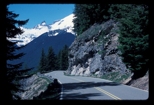
Can you imagine what it was like to build the Sunrise Roads in 1929? In the 10 miles from White River Campground to Sunrise parking lot, the road climbs up the steep sides of the White River Valley. Carved by the once 1,000 foot tall Emmons Glacier, it is a very steep slope. The hillside is made of rocks, boulders, and fine materials left behind by the Osceola Mudflow nearly 5,600 years ago. Higher up, it’s hardened lava from volcanic eruptions. In 1929, through 4 different construction contracts, crews worked their way upwards carving the road out of the mountain. The road was completed the next year and construction began on the infrastructure and buildings at Sunrise.

Though closed right now, when it opens for the summer, the Sunrise Road and the many trailheads at Sunrise itself are very popular and have been for many decades. When was the last time you drove up this road along the valley walls of the White River? What is your favorite spot for pictures? ~ams
The Sunrise Road and White River Campground are currently closed. Updates on their opening can be found at https://www.nps.gov/mora/planyourvisit/road-status.htm and https://www.nps.gov/mora/planyourvisit/hours.htm . For more information on the history and archaeology of the park, see https://www.nps.gov/mora/learn/historyculture/index.htm
NPS/B. Bullard Photo. View of an old car driving downhill on the Sunrise Road with Mount Rainier in the distance. September, 1963. NPS/L. Lane Photo. Sunrise Road with columnar andesite on the roadside. Mount Rainier in background. Circa 1987. NPS/Scott Photo. View from near Camp Schurman looking down on Yakima Park and Sunrise Road. August, 2004.
#encuentra tu parque#find your park#history#roads#Sunrise#national parks#mount rainier#mount rainier national park
29 notes
·
View notes
Text
2021 Heat Event
While this spring has been the cool and snowy, last year between June 25-30, 2021, the Pacific Northwest experienced an extreme heat wave that broke many records. Temperatures recorded at Paradise COOP station (90°F) and Longmire COOP station (105°F) were near or matched the all-time records. All values were the highest ever recorded for the month of June. All time high temperature values were logged at two high elevation weather stations with shorter periods of record: 87°F at Sunrise (6,420 ft) and 64°F at Camp Schurman (9,500 ft).
The extreme heat led to rapid snowmelt. Snowmelt at the Paradise COOP station from April 1 through June 25th averaged about 2” every day. On June 25 (early in the heat event), snow height was 64” at Paradise. Only five days later it measured 24”, melting 8” per day, four times the previous rate of melt. The Nisqually River passing the Longmire Bridge stream gauge showed a 57% increase in maximum daily water volume (when compared to averaged daily maximum values recorded earlier in the month). Swollen rivers damaged many trail bridges in the park.

NPS Photo of the Nisqually River overwhelming the log bridge along the Wonderland Trail near Cougar Rock Campground, around noon on 6/26/21.
The North Coast and Cascades Network (NCCN) Inventory and Monitoring Program monitors climate in order to compare current and historic data to understand long-term trends, to provide data to model future impacts to park facilities and resources, and to provide park staff with information needed to make management decisions.
Read more about the 2021 heat event in the “Weather Summary: Mount Rainier National Park – Water Year 2021” monitoring brief.
Additional reports are posted at https://www.nps.gov/im/nccn/climate.htm.
~kl
#Rainier Science#mount rainier national park#heat wave#weather#extreme weather#climate monitoring#climate
19 notes
·
View notes
Photo

Did you catch that red sunrise this morning? Wildfire smoke in the park is affecting air quality, but it does make for some colorful sunrises and sunsets! This sunrise was captured yesterday from Camp Schurman.
SR410 is still closed during the day due to the Norse Peak fire to the east outside of the park. SR410 is currently opening at night from 8pm-6am. Stay up to date with current road conditions and closures at https://www.nps.gov/mora/planyourvisit/road-status.htm
NPS Photo. Panorama of the ice and snow covered summit of Mount Rainier tinted pink from a red sunrise. ~kl
20 notes
·
View notes
Text
The north side of the mountain has some of the park’s biggest glaciers; the Emmons, Carbon and Winthrop Glaciers.

Like its sibling the Emmons Glacier, the Winthrop Glacier starts near the summit. Together, the two great rivers of ice slide down the northeast and north sides of the mountain until they crash against Steamboat Prow. Then the rocky wedge of the Prow separates the glaciers. Emmons flows more easterly and forms the headwaters of the White River. The Winthrop Glacier stays more to the north and starts the West Fork of the White River. The two rivers join together outside the park boundaries and make their way towards the city of Enumclaw.

The Winthrop Glacier is not only long, over 4.5 miles, it also has some pretty serious surface area, about 3.4 square miles. During the summer, it’s possible to get great views of the Winthrop Glacier from many areas in and around Sunrise. As winter snows start to collect in the higher elevations, the road to Sunrise closes for the winter. It’s still possible to get good views from in towns like Enumclaw, Bonney Lake, and many other places. What is your favorite place to see the Winthrop Glacier? ~ams
More information on Mount Rainier’s glaciers can be found here https://www.nps.gov/mora/learn/nature/glaciers.htm
NPS Photo. View from Camp Schurman on seasonal webcam looking up the Emmons and Winthrop Glaciers towards the summit. September, 2017. NPS Climbing Ranger Photo. View of Climbing Ranger enjoying sunrise on the upper Winthrop Glacier. Steamboat Prow visible in center of image as Winthrop Glacier descends from right to left. May, 2019.
#encuentra tu parque#find your park#mount raineir#mount rainier national park#glacier#ice#national parks
21 notes
·
View notes
Text
Not to toot our own horn, but this mountain has some great glaciers.
Small ones, tall ones, hanging, and even low ones. But one of the biggest of the bunch is the Emmons Glacier. It has the largest area of any glacier in the lower 48 states with about 4 and a quarter square miles of ice.

Sitting on the northeast side of the mountain, the Emmons Glacier grabs your eye. It starts near the summit, at the edge of the craters and slides it’s way down the mountain slope. Going past Little Tahoma, it glances off Steamboat Prow, the home of Camp Schurman. Then it slips down the valley along the side of Goat Island Mountain before ending near 4,900 feet above sea level.

Popular with climbers using the Emmons-Winthrop climbing route to the summit, the Emmons Glacier also has a starring role in many photographs on the mountain. Whether glimpsed from State Route 410, from the Glacier Basin and Emmons Moraine trail, or the many view points in the Sunrise area, this glacier fills up the camera lens.

Have you taken a stunning picture of this glacier? What’s you favorite Emmons Glacier memory? ~ams
For a current image of the Emmons and Winthrop Glaciers from Camp Schurman (9510 ft above sea level), visit our webcam at https://www.nps.gov/media/webcam/view.htm?id=81B46438-1DD8-B71B-0BDDDE3FF288F323
More information the mountain’s glaciers can be found at https://www.nps.gov/mora/learn/nature/glaciers.htm
For climbing information on the Emmons-Winthrop Route visit https://www.nps.gov/mora/planyourvisit/upload/Emmons-Winthrop-Routebrief-2017_FINAL.pdf
NPS/E. Bouwer Photo. View from overlook at Sunrise of Emmons Glacier from toe to head with Mount Rainier’s summit and Little Tahoma visible. July, 2014. NPS Climbing Ranger Photo. Climber’s view looking up the Emmons Glacier from Emmons Flats up to the Corridor. August, 2019. NPS/C. Roundtree. Climber’s view of sunrise looking down the Emmons Glacier. August, 2004.
#findyourpark#encuentratuparque#nationalparks#mount raineir#mount rainier national park#emmons glacier#ice#glaciers
32 notes
·
View notes
Text


Most everyone knows the answer to the age old question “does a bear poop in the woods?”
Yes. Bears do poop in the woods.
But, what about humans? Should they poop in the woods? Or on a glacier?
When looking at ways to keep the park clean, following Leave No Trace guidelines are your best bet. Backcountry pit toilets, proper “cathole” technique and packing out all trash are ways you can help keep the park clean.
Up in the high elevations, like on glaciers, you can either use the toilets at Camp Muir and Schurman, or the next best thing, blue bags.
Climbing rangers, and all the park staff, care about keeping our glaciers and water supplies as clean and healthy as possible. Blue bags are just one more tool rangers are using to do that.
So if folks walking their dogs can bag waste, so can all the folks on the snowfields, glaciers and other high places within the national park. Just like doggie bags, the human waste gets bagged and carried out. In places like Paradise and White River, there are specific barrels for disposing of used blue bags. It’s one way you can help keep Mount Rainier beautiful.
In what ways have you helped keep the park pretty? ~ams
NPS Photo (top) Looking up the Muir Snowfield towards Camp Muir and Gibraltar Rock. August, 2019. NPS Photo (bottom) Empty blue bags on a wooden bench. November, 2019.
14 notes
·
View notes
Text


Do you like looking at Mount Rainier National Park’s webcams?
Is the sight of the mountain from Sunrise at sunrise something you like to enjoy every morning before work? Do you eagerly await the late Spring and the return of the Camp Muir webcam?
If so, you probably noticed something new going on up there. Park carpenters are hard at work building a toilet. Not just any toilet, a really cool high-elevation toilet to help keep the mountain clean. You might see some of the carpenters working from time to time in front of the webcam. You might see them using different tools. Even see a tool box sitting beside the new toilet. But think for one moment about how that tool box and tools got up there, all the way up to 10,800 feet above sea level.
When you work on something at home or work, most of the time your tool box doesn’t have to take a long trip from the work bench to the work site. Our carpenters’ tools made a pretty big trip. A few things get there on the back of our carpenters, hiked up 4.5 miles and over 5,000 feet from Paradise. Big supplies and many tools were flown up in cargo loads hanging from the park contract helicopter. Sure, they’re using everyday, regular tools like saws, hammers, drills, etc, but those tools had a heck of a journey to get there.
Have you watched the Camp Muir webcam and seen some of the park carpenters at work? ~ams
To catch a glimpse of Camp Muir, Camp Schurman and Sunrise webcams before they close down for the winter, please visit https://www.nps.gov/mora/learn/photosmultimedia/webcams.htm
NPS/A. Spillane Photo (top). Wall covered in tools in carpenters’ shop. NPS Photo (middle top). Camp Muir webcam with carpenter working on toilet. NPS Photo (middle bottom). Camp Muir’s new west toilet open for business wile awaiting stone veneer work. August, 2019 NPS/T. Maine Photo (bottom). Supplies prepped to fly to Camp Muir. August, 2019.
26 notes
·
View notes
Last Seen Blogs

thinkingthroughpink
Thinking Through Pink

vampireholliie
fifty shades of tired

dollylollyy
Untitled

bebetos
Bebetos_com

jmiemagvans
I'm a nurse, what's your superpower?