#washington geological survey
Text
12 Sep 23
On September 4, the Japanese Supreme Court ruled that Okinawa Governor Denny Tamaki is legally obligated to approve the relocation of a U.S. military base from the Okinawan district of Ginowan to Henoko district in the prefecture’s Nago city. The decision follows Tamaki’s years-long legal battle to prevent the relocation after landfill work, which began in 2018, unearthed the fact that a significant portion of the sea floor where the base is being built was too soft to support the original construction plan.
In April 2020, the Japanese Defense Ministry’s Okinawa Bureau attempted to submit a revised building plan to account for the soft ground, which civil engineers described as “soft as mayonnaise,” but that was rejected by Tamaki in November 2021, after he claimed there was “insufficient research” into whether the revised plan would be feasible. Previous geological surveys indicated that the seabed was so soft that the base is likely to continuously sink. Tamaki claimed that “it was unacceptable to proceed with the construction of a new base that has no prospect of being completed.”[...]
Tamaki won a second four-year term in September 2022 by defeating Sakima Atsushi, who had the backing of the Liberal Democratic Party, which controls Japan’s government. Notably, Sakima was supportive of the U.S. base in Henoko. Tamaki’s re-election, while expected, thus highlighted how contentious the U.S. military still remains for the local populace given the unequal burden placed on Okinawa by U.S. bases.
While only accounting for 0.6 percent of Japan’s territory, the prefecture houses 70 percent of the 50,000 U.S. troops in the country[...] Okinawa has a crucial role in both Washington and Tokyo’s security posture toward China[...]
Despite that, many Okinawans have called for a reduction of military personnel on the island. A 2022-2023 public opinion poll conducted by researchers at several universities, including the University of the Ryukyus, found that nearly 70 percent of local residents think the heavy concentration of U.S. military personnel in Okinawa is “unfair.”[...]
the fortification of Japan’s defenses through Okinawa is also being used to counter [...] Russia and North Korea.[....]
it is highly unlikely that the Japanese prime minister will give in to the demands of the Okinawan people for a reduce U.S. military presence. This will ensure that anti-U.S. military sentiment will remain high on the island as Japan-U.S. security cooperation continues to strengthen.
14 Sep 23
79 notes
·
View notes
Text
Scientists Buzzing After Unique Native Bee Colonies Discovered Right on Their College Campus https://www.goodnewsnetwork.org/scientists-buzzing-after-unique-native-bee-colonies-discovered-right-on-their-college-campus/

“””In a charming coincidence, a pair of bee and insect specialists from Washington College are buzzing with excitement about a unique and newly documented population of native bees right on their very own campus.
Although the large group of ground-nesting bees has been noticeable on one corner of the campus for years, recent identification of at least five different species all using the same area has sparked interest from researchers.
The section of the college green located in front of East and Middle Halls is a hotspot for these vital pollinators, with ground-nesting ‘mining’ bees from the Andrena and Colletes genera thriving on the hill at the base of the halls.
Recently, thanks to her keen eye and love of insects, photographer Pamela Cowart-Rickman realized that the area has multiple species of native mining bees all nesting together, something that has not been well documented.
Cowart-Rickman, who studied biology at WC as an undergrad and developed a love of insects has tentatively identified five different species that are all sharing the same nesting grounds. They include four different Andrena (mining bees), one Colletes (cellophane bees), and likely three cuckoo bees in the genus Nomada.
The Washington College site provides rare nesting habitat for multiple native bee species, several of which are uncommon and unidentified,” said Sam Droege from the US Geological Survey’s Bee Lab.
“We always talk about providing plants to support native bees and other pollinators, but we rarely think about providing adequate nesting habitat for their survival. These native bees provide beneficial pollination to fruiting trees and plants, not only on the College campus, but also the Chestertown community.”
“They have been nesting amongst and on top of each other for several years in this same location,” said Cowart-Rickman of the bees she has spotted. “The various Andrena have the largest nesting area and emerge first in late February. The Colletes have a smaller area and emerge later in late April.”
Cowart-Rickman devotes her free time to photographing insects and has been helping researchers identify and track populations. She has found and documented several species for MD Biodiversity, BugGuide, iNat, and researchers at the Canadian National Collection of Insects.
When she realized what she had stumbled upon right outside her own office building on campus, she reached out to Dr. Beth Choate, deputy director of the Washington College Center for Environment and Society. Choate, who has published research on the abundance of wild bee populations in urban and rural gradients, was also intrigued by the nesting sites Cowart-Rickman had found. The two decided to investigate further.
“On a nice day in the spring, you can see the male bees hovering right at grass level. There were hundreds of these males searching for a female to mate when we were out there,” said Choate.
Females create a small burrow in the ground for rearing young and a ball of pollen and nectar is placed in each to feed the larval bee when it emerges from the egg, Choate explained. Once the males and females mate, the female returns to her nest and lays the egg in the carefully constructed burrow to develop.
“Ground-nesting bees need bare, minimally covered ground in order to dig into the soil. They also prefer sunny and well-drained soil, but it will be interesting to learn what is unique about the soil in this space and why the aggregation has become so large,” said Choate.
“Since ground-nesting bees are solitary and do not form colonies, they generally aren’t as noticeable as this aggregation. Females often create nests near one another; however, an aggregation this large is unique.”
After seeing one of Cowart-Rickman’s nesting bee photos on iNat, and realizing the rarity of the site, Dr. Jordan Kueneman, a researcher with Project GNBee who is working on tracking ground-nesting bees at the Danforth Lab at Cornell University, reached out to Cowart-Rickman about possibly providing further research samples and information.
“We were very excited to learn about the ground-nesting bee aggregations at Washington College, for a myriad of reasons,” said Kueneman. “First, the size of the aggregation is substantial, and multiple species are utilizing areas of the overall site to nest. This scenario is ideal for understanding nesting requirements for bees and how those vary by species.
“Second,” Kueneman continued, “intermixed aggregations of nesting bees are particularly interesting to study from an ecological perspective, as the cost/benefits of varying nesting strategies and behavior can be more easily studied, particularly in the context of phenology, nest architecture, and risk of parasitism.”
He noted that due to its location, the Washington College aggregation can easily provide the opportunity for students and the public to learn about the biology of ground-nesting bees and the value they provide to the environment. He is also hopeful that knowledge of the history of the area and the site’s management can help inform how ground management practices on campus have impacted the population in the past and provide opportunities to explore how current management will impact this population in the future.
Research and monitoring of the aggregation will continue as teams from both schools work together to study what makes this site so appealing to multiple species of bees.
#good news#environmentalism#science#environment#nature#bees#insects#animals#conservation#ground bees#ground nesting bees#burrowing bees
29 notes
·
View notes
Text

"Dr. Matt Carrano is curator of dinosaurs at the Smithsonian Institution in Washington, D.C. He was one of the authors of the paper announcing the discovery of Yellowstone’s Tyrannosaurus from a single tooth found inside Yellowstone National Park more than 50 years ago.
U.S. Geological Survey geologist Joseph Leonard Weitz found the tooth in 1966 as part of a geologic team mapping Big Game Ridge near Mount Hancock in the southeastern corner of Yellowstone. Carrano said while many geologic surveys explored Yellowstone, there wasn’t much expertise or interest in fossils.
“People were out exploring in general or trying to understand the basic geology,” Carrano told Cowboy State Daily. “Along the way, they would stumble upon fossils, which they would collect.
“Usually, they’d make a brief note, ‘We found a tooth of a dinosaur,’ and then it goes into the geology collection and oftentimes gets overlooked. This is a great opportunity to rediscover it in the collections of the museum.”
The rediscovery of Yellowstone’s first dinosaur started when fossils from the U.S. Geological Survey were moved from a facility in Colorado to the Smithsonian’s collections. The fossil had been noted in a few geologic papers since it was discovered, but it had been misidentified or barely mentioned.
As Carrano and his team went through the newly acquired USGS collection, they were looking for the tooth. Once it was located, a team of paleontologists set out to redescribe the tooth and determine which dinosaur it belonged to.
“This is the first identifiable dinosaur fossil from Yellowstone that we are aware of,” he said."
Read more: "A Tyrannosaurus Is The First Confirmed Dinosaur Fossil Found In Yellowstone" by Andrew Rossi.
#palaeoblr#Palaeontology#Paleontology#Tyrannosaurus#Tyrannosaurus rex#Dinosaur#Fossil#Theropod#Cretaceous#Mesozoic#Extinct#Prehistoric#Information#Article
67 notes
·
View notes
Text
A surprising byproduct of wildfires: Contaminated drinking water. (Washington Post)

Over the weekend, the Park Fire grew to more than 360,000 acres, prompting evacuation orders and warnings around Chico, Calif. in Butte, Plumas, Shasta and Tehama counties. In the days ahead, Cal Fire will seek to contain the blaze to reduce harm to people, structures and the environment. However, months from now when the rains come and the fires are extinguished, a hidden threat could put communities at risk once again.
When the mayor of Las Vegas, N.M., issued a warning in 2022 to its 13,000 residents, it wasn’t over a fire — they had recently lived through the state’s largest wildfire in its history: Calf Canyon/Hermits Peak. The dire warning was that the city had 30 days of clean water left. The 2022 monsoon rains covered the Gallinas watershed, where cleared trees from the Santa Fe National Forest and ash-covered grounds made for flash-flood conditions. The storms introduced massive amounts of carbon from burned trees and plant life into the streams and reservoirs. Water treatment couldn’t keep up, making their stores undrinkable.
Around 60 to 65 percent of the United States’ drinking water comes from forested areas. As fires burn in these areas, they increase the risk of cancer-causing and toxic substances entering water supplies. An estimated 53.3 million U.S. residents who live in areas with significant wildfire risk may face damaged drinking water infrastructure from those flames.
Megafires burn land at higher temperatures across wider areas than standard wildfires, putting watersheds across the United States at greater risk. Sheila Murphy, a research hydrologist at the U.S. Geological Survey working on the effects of wildfires on water quality, says burned areas fundamentally alter a watershed’s hydrology. As wildfires burn hotter and consume more trees and structures, water quality will continue to worsen, research suggests.
When watersheds burn, the threat starts in the forests, continues to water treatment plants, and can expand to communities and households. To meet these risks, it will take a coalition of informed community members, scientists and city officials to work toward solutions to protect clean water supplies.
12 notes
·
View notes
Text
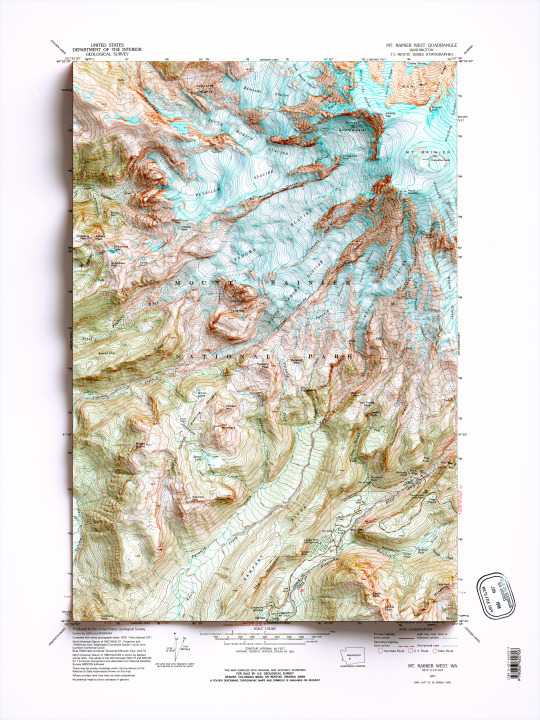
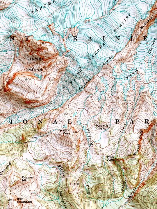
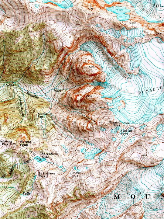
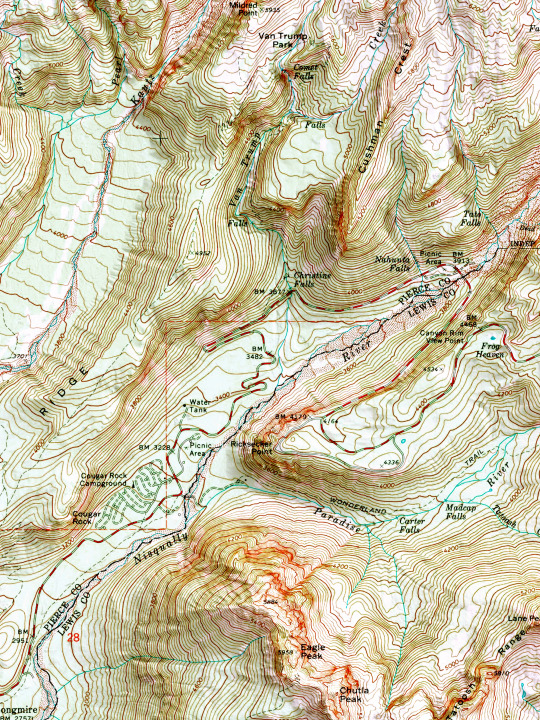
2D printed shaded relief map with 3D effect of a topographic map of Mount Rainier West, Washington (United States of America), from the Quadrangle series map and prepared and published by U.S. Geological Survey in 1971.
If you like our work, want to see our daily updates (or want to say hello to our studio), consider to follow our Instagram or Twitter account. Otherwise if are interested in our prints or have a custom request check our shop.
#mtrainer#mtrainernationalpark#mtrainiersummit#Washington#washingtontrails#mountaineering#mountainlife#mountain#topographic#topographicmap#wallart#wallartprint#mapdesign#naturegeography#wildgeography#usanaturetour#mtrainierdesign#mtrainierwatch#framedart#framed
67 notes
·
View notes
Text


Earthquake Point/Broken Mountain, WA
Take a step back in time to December 14, 1872 in what was at that time Washington Territory. Ulysses S. Grant had just been elected president for his second term, and Boston was still recovering from the Great Fire that destroyed much of the city in November of that year. You had to draw water from a well, light your cabin with oil lamps, and typically folks would retire for the night shortly after sundown, when the evening chores were completed, and supper dishes were cleaned.
On that night, at almost 10pm, folks across the region were awakened by a massive earthquake. Contemporary accounts describe the earth rolling from North to South, no jolting bumps, just the feeling like walking on the deck of a ship in rough seas.
The earthquake impacted an area of the Pacific Northwest over 625,000 miles – from Salem Oregon in the South, to Victoria, BC in the North, across Idaho into Montana and much damage was sustained in the populated areas west of the Cascades. In Seattle buildings rocked, trees shook, items and fell off shelves. Pendulum clocks were stopped by the offsetting rocking, or started up again, if they had been stopped. Plaster walls cracked and lamps tipped over.
Prior to the event, Lake Union had been flat calm, but the quake caused a tidal wave several feet high. In Olympia there were reports of fireplaces crumbling.
Jack Splawn (also known as Moses Splawn) was a cowboy and resident of Yakima City at that time. He explained that he and the other cowboys on the ranch had just completed the year’s branding and were celebrating at the Sagebrush Saloon, when the building began rocking and they ran outside to see what hoodlums were trying to tip the house over.
While some folks dealt with milk sloshed out of the pail, and knickknacks falling off the shelf, the residents of North Central Washington, especially indigenous tribes who lived along the Columbia river near Chelan witnessed a far more catastrophic event. It is known locally as “the night the mountain fell.”
As you drive along Highway 97A just past Entiat on your way to Chelan, there is a roadside pullout and marker explaining “Earthquake Point.” Here you can view what the native people named “Ribbon Cliffs”. A giant portion of the hillside of Broken Mountain fell into the Columbia river that night. Of course, the river was not as high then as it is now, as the hydroelectric projects along the river have raised it, however, the amount of earth and granite that fell blocked the river and flooded the lands behind it, including the ranch of the Wapato family. You might recognize that tribal name from the peninsula of land at Lake Chelan, called Wapato Point.
At some point the following day the water broke through the earthen dam, the flood receded, and the river began to flow again. It must have been a sight to behold if you lived in Wenatchee to wake up to a dry riverbed! Witnesses to the event reported that it took several days for the earthen dam to break up and the river to return to its previous level.
While there was no seismologic equipment in place seventeen years before Washington became a state, experts studying the damage and geologic features believe the quake was between 6.5 and 7.5 in magnitude. That makes it one of the largest on record in the state.
For 143 years it was a mystery where the epicenter of this earthquake could be found. In 2015 geologist Brian Sherrod painstakingly surveyed a canyon between Chelan and Entiat, where he found a fault and was able to definitively prove it to be the source of the quake.
Source
#Earthquake Point#Broken Mountain#Ribbon Cliff#white volcanic ash#Chelan County#travel#original photography#vacation#tourist attraction#landmark#landscape#contryside#summer 2023#USA#Pacific Northwest#Washington#flora#nature#Columbia River#tree#geology#US history
2 notes
·
View notes
Text
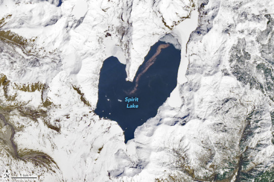
The Lovely Shape of Spirit Lake
"Spirit Lake is resilient. The lake and once-popular tourist site in south-central Washington was nearly obliterated in May 1980 during the events that unfolded around the cataclysmic eruption of Mount St. Helens. The lake survived, and it took on a lovely new shape.
The OLI (Operational Land Imager) on Landsat 8 acquired these images on April 26, 2023. A white blanket of snow contrasts with the dark-blue water, emphasizing the lake’s heart-like shape when viewed from above.
Prior to the eruption, Spirit Lake had a smaller footprint that consisted of west and east arms connected by a narrow span of water—similar in shape to the top-half of a heart. Then, on May 18, 1980, the volcano’s north flank let loose, producing the largest-known landslide in recorded history, followed by a lateral blast and shock wave as the eruption unfolded. The water in Spirit Lake was temporarily displaced but eventually flowed back into the basin.
A “new” lake reformed atop the debris from the landslide. The fully-heart shaped lake was broader and shallower, and the elevation of its surface higher by nearly 60 meters (200 feet). Some of the landslide debris formed a blockage, or natural dam, on the lake’s southwest side. Without an outlet, water levels continued to rise until engineers constructed a drainage tunnel in 1985.
From the 1920s through the 1970s, Spirit Lake drew tourists to its shores. Cabins and lodges lined the lake, and people could swim, boat, and fish in its waters. Today, those lakeside features are buried in avalanche debris below the modern lake.
Fishing and swimming are prohibited, and access is limited to preserve the site as a natural laboratory for studying the landscape’s recovery. For example, scientists think that the trees uprooted by the volcanic blast and still floating in the lake, visible as the brown line in the detailed image above, have become an important part of the lake’s ecosystem."
NASA Earth Observatory images by Wanmei Liang, using Landsat data from the U.S. Geological Survey. Story by Kathryn Hansen.
6 notes
·
View notes
Text
A landslide that struck a remote part of Papua New Guinea on Friday may have killed more than 2,000 people.
The death toll was reported in a letter seen byThe Associated Press that was sent by National Disaster Center Acting Director Luseta Laso Mana to the United Nations resident coordinator on Sunday.
"The landslide buried more than 2,000 people alive and caused major destruction to buildings, food gardens, and caused major impact on the economic lifeline of the country," Mana wrote.
The landslide buried the village of Yambali in Enga Province beneath 20-26 feet of earth, according to U.N. News. It took place at around 3:00 am local time on Friday, May 24.
"It has occurred when people were still asleep in the early hours and the entire village has gone down," Elizabeth Laruma, the president of the Porgera Women in Business Association, told the Australian Broadcasting Corporation (ABC).
Laruma said the entire face of the mountain collapsed, squashing homes. Images showed rescue workers moving around downed trees and boulders. Some of the stones unleashed were larger than shipping containers.
"I have 18 of my family members being buried under the debris and soil that I am standing on, and a lot more family members in the village I cannot count," resident Evit Kambu told Reuters. "But I cannot retrieve the bodies, so I am standing here helplessly."
Initial reports put the death toll at around 100. Then, on Sunday, Serhan Aktoprak, country head of the U.N.'s International Organization for Migration (IOM), said that approximately 670 people were thought to be buried under the debris and that "hopes of finding them alive are shrinking."
It is not clear how the government reached its figure of more than 2,000 dead, and IOM has not altered its figures.
"We are not able to dispute what the government suggests but we are not able to comment on it," Aktoprak told AP, adding, "As time goes in such a massive undertaking, the number will remain fluid."
The landslide covered 150 homes and displaced around 1,250 people, according to IOM. It also blocked off the only highway traveling into the affected province, making rescue operations more difficult. So far, only five bodies have been pulled from the debris, according to AP. Rescue workers and survivors had been attempting to dig people out of the earth with shovels and farm equipment until the first excavator was donated by a local construction business on Sunday.
In the letter to the U.N., Mana said the ground was still shifting, making the situation "unstable" and posing "ongoing danger to both the rescue teams and survivors alike."
There have also been challenges delivering aid to the survivors: a Saturday delivery brought tarps and water but no food, while the local government gathered food and water on Sunday for only 600 people, The New York Times reported.
"This situation necessitates immediate action and international support to mitigate further losses and provide essential aid to those affected," IOM spokesperson Anne Mandal told the Times.
...
The cause of Friday's landslide is under investigation, according toThe Washington Post, but some people in the area have attributed it to a lightning strike or a month of heavy rainfall. The mountain was also already unstable because of a previous landslide, according to U.S. Geological Survey geologist Kate Allstadt.
Papua New Guinea is often struck by fatal landslides, according to ABC. Partly this is because it is a mountainous, tropical country on the Ring of Fire, where both heavy rainstorms and seismic events can destabilize hillsides. It also has a poor, rural population who are more likely to live in a landslide's path.
However, human activities also increase the risk, with industries such as mining, logging, and liquefied natural gas destabilizing terrain or contributing to deforestation. The climate crisis also makes extreme weather events that trigger landslides more likely.
4 notes
·
View notes
Text
Poppycock And Bunkum: Here Are 19 Myths That Cincinnati Refuses To Give Up
Cincinnati loves a good story, and we certainly have some doozies. Some of our favorite stories about our favorite town are actually true. Some of our dearest and most treasured stories, however, persist despite a complete lack of evidence and not an iota of proof. Among them:
Cincinnati is located upon seven hills.
To be geologically technical, Cincinnati has no hills at all, only valleys. The central basin in which our downtown is located is surrounded by what geologists call an eroded peneplain. In other words, our town occupies a glacially scoured, level plain into which streams have cut a network of valleys. What we count as “hills” are just tongues of this surrounding plain extending into the central valley – and once we start counting those, there’s no stopping. One recent survey has identified at least 80 named Cincinnati “hills.”
A woman named Ida Martin, who lived in a hollow sycamore tree and did laundry for the soldiers at Fort Washington, gave her name to Mount Ida, later renamed Mount Adams.
It is authentically reported, by an eyewitness, that a woman who did laundry for the soldiers at Fort Washington lived in a hollow sycamore tree on the slopes of what later became Mount Adams. However, that source does not give her name. There was a domestic servant named Ida Martin who lived on what later became Mount Adams, but this was long after Fort Washington had been demolished, this woman was not a laundress and she lived in a cabin, not a hollow tree. Mount Adams was previously known as Mount Ida, but that nickname was a reference to classical mythology, not to any woman who lived in the area. Somewhere along the line, these three separate facts got conflated into a treasured Cincinnati fable.
Arnold’s Bar opened on Eighth Street in 1861 and three generations of Simon Arnold’s family lived upstairs for 98 years (brewing gin in a bathtub).
According to the Cincinnati City Directory, Simon Arnold indeed occupied part of a building on the north side of Eighth Street, just east of Main in 1861. However, he was not running a saloon. He was building billiard tables, because he was a carpenter until 1877. From 1856 to 1877, there was a saloon on the north side of Eighth Street, just east of Main, but it was run by George and Wilhelmina Weber, not anyone named Arnold. The Arnold family did not take over that saloon until 1877, when Wilhelmina Weber retired. From 1922 until 1933, no bar, saloon, speakeasy or restaurant operated out of that address at all. No one from the Arnold family lived in that building from 1926 until 1933. The story of Arnold’s founding date and continuous occupancy appears to have been embellished by Elmer Arnold in 1959 when he sold the venerable establishment to Ernst Wiedemann.
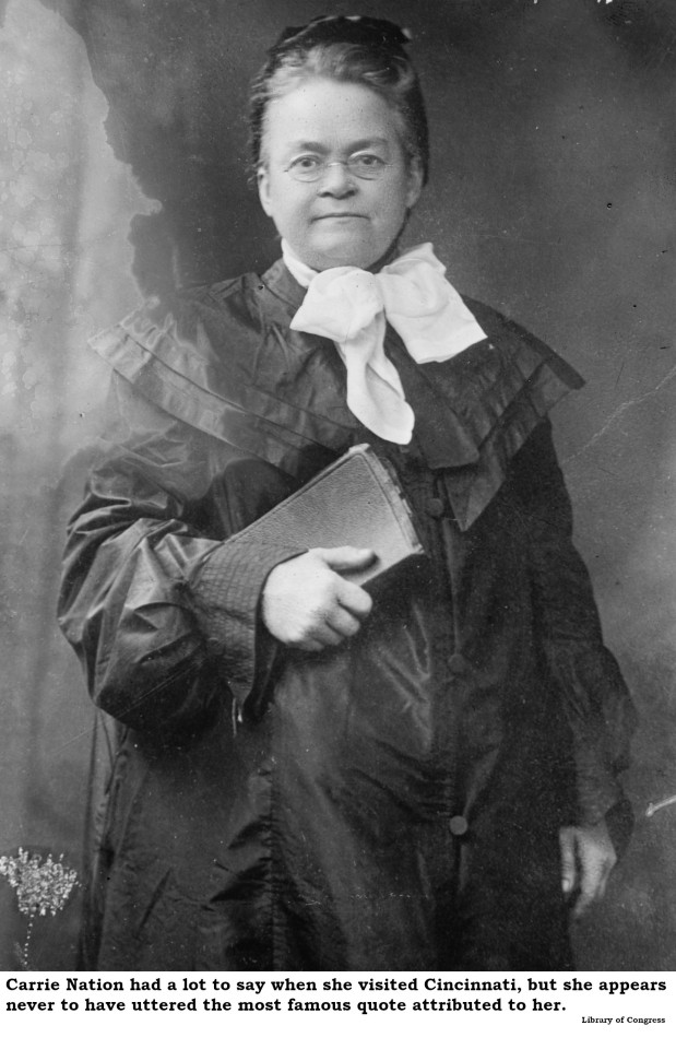
Carrie Nation, on a visit to Cincinnati, declined to smash any of the notorious Vine Street saloons, claiming, “I would have dropped from exhaustion before I had gone a single block.”
Carrie Nation did, in fact, visit the Queen City at least twice. During her visits, she did not demolish a single saloon. She also gave numerous interviews while she was in town. In none of those interviews did she claim exhaustion prevented her from attacking Cincinnati saloons. Rather, she pointedly explained that she arrived here under a court-imposed performance bond she would forfeit if she demolished anything. The famous quote does not appear in print until 20 years after her Cincinnati visits.
Mark Twain said, “When the end of the world comes, I want to be in Cincinnati because it's always 10 years behind the times.”
Everyone quotes Mr. Samuel Clemens and his eschatological analysis of the Queen City, but no one has ever provided a decent citation for it. The quote appears in none of his voluminous writings. To confuse matters, multiple scholars have found similar quotes attributed to quite a few famous folks about quite a few other cities. To further confuse matters, the quote sometimes appears as one sentence and sometimes as two sentences and the lag, while usually 10 years, is sometimes 20 years. In brief, if Mark Twain ever uttered such a comment, no one appears to have recorded it.

The Cincinnati subway failed because of poor design and cost overruns.
In his exhaustive review of “Cincinnati’s Incomplete Subway” (2010), Jacob R. Mecklenborg notes that, despite the usual financial shenanigans of the Boss Cox political machine, Cincinnati’s Rapid Transit Loop project (which we know as the subway) was actually pretty well thought-out and potentially quite viable. Mecklenborg concludes that the newly elected Progressive city administration of 1925 could have saved the project but declined to do so to avoid giving the remaining Cox minions a victory. Most of the alleged shortcomings of the subway were actually unfounded Progressive propaganda from the 1920s.
Charles Manson attended Walnut Hills High School and/or used to hang out in Mount Adams.
After his arrest and conviction in California, Cincinnatians suddenly began remembering Charles Manson’s early days in Cincinnati. Or, shall we say, misremembering? All the documentation – and Manson’s life has been inspected to the subatomic level – affirm that young Charles was shipped out of Cincinnati by age five, never to return. While it’s not impossible that he drifted through town from time to time, his high school years were spent in various reform schools. The period in which he allegedly hung out, swilling tequila in Mount Adams, find him involved in West Coast scams or serving time in California prisons. We can’t deny he was born here, but there’s no evidence Manson returned after an unhappy infancy.
Cincinnati Chili gets its distinctive flavor from chocolate.
A great many Cincinnatians inaccurately yet vehemently insist that the secret ingredient to Cincinnati Chili is chocolate. Most “authentic” Cincinnati Chili recipes in print or online make this claim. The myth may be traced to Marion Rombauer Becker, who took over compiling the “Joy of Cooking” on the death of her mother, Irma Rombauer. Marion’s “Cincinnati Chili Cockaigne” recipe (the “Cockaigne” label signaled that the Rombauers served that dish at their home in Cincinnati) was the first to claim a dubious role for chocolate. As Cincinnati Chili maven Dann Woellert has repeatedly noted, the families who actually cooked and served our favorite dish deny there’s any chocolate involved.
Thomas Edison read every book in the old Ohio Mechanics Institute library.
Young Tommy Edison spent a fruitful year in Cincinnati as a telegraph operator and he even did some tech support for the early Procter & Gamble. For a young inventor, the most useful resource in Cincinnati would have been the library of the Ohio Mechanics Institute, with 10,000 volumes on science and technology. However, to read every book, Edison would have had to consume 27 volumes a day and master a dozen languages. Edison sent an autographed photo to the Institute in later years, thanking them for allowing him to use the library and maybe that’s where the rumor started.

The first bathtub in the United States was installed in Cincinnati
A satirical essay by H. L. Mencken, titled "A Neglected Anniversary," was published 28 December 1917, in the New York Evening Mail. Mencken claimed that the first bathtub in the United States was installed in a Cincinnati home by one Adam Thompson in 1842. Although this was totally “fake news,” it was repeated as truth many times over the next century and still pops up as “fact” online today.
Superman is buried in Spring Grove Cemetery
The earthly remains of George Reeves, the actor who played Superman on television during the 1950s, were held in a vault at Spring Grove Cemetery for a couple of months in 1959 while his mother sorted out a permanent resting place. Although she wanted a mausoleum in Cincinnati, it proved impracticable. Reeves’ body was eventually cremated here and the ashes shipped to California, where they remain today.
UC’s Crosley Tower entombed an unfortunate worker during construction.
Crosley Tower at the University of Cincinnati is a monument to brutalist architecture and is now scheduled for demolition. It was originally poured in 1969 as a single piece of concrete. Rumor has it that a workman fell in as the slurry was being pumped, and because the pour could not be interrupted without extravagant cost, he remains entombed there. Construction of this building was heavily documented and no one fell in. Rumors that workers dropped a Volkswagen into the mix while pouring are also false.
There’s a village of evil midgets out by Mount Rumpke.
Although the rumor was disproved years before the alleged “Munchkinville” was demolished, there are still people who swear a “Tiny Town” of malicious little people exists out in Colerain Township. All the rumors trace back to the Handle Bar Ranch, originally a bicycle rental station later devoted to horse-drawn hayrides, owned by the late Percy and Anna Ritter. Mr. Ritter’s idiosyncratic architecture and Mrs. Ritter’s unusual décor inspired generations of high school students to mount midnight forays looking for munchkins. The alleged Tiny Town has been consumed by the expansion of the Rumpke waste disposal operation.
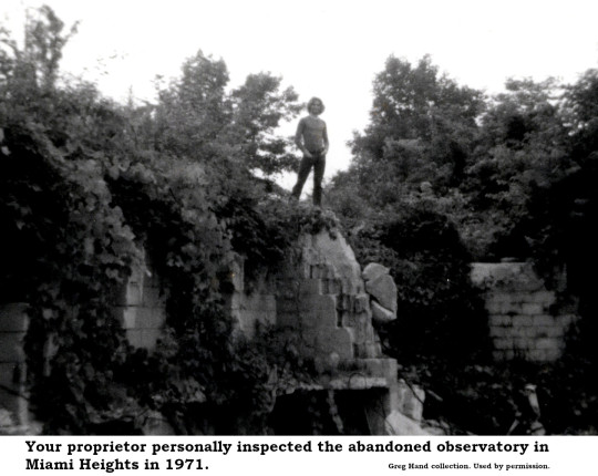
There is an exploded crematorium once used for Satanic rituals in Miami Heights.
There is most definitely something out in the woods near Buffalo Ridge Road in Miami Heights, but it has nothing to do with Satan. After Cincinnati’s “fireproof” Chamber of Commerce building burned in 1911, the massive granite masonry was acquired by the Cincinnati Astronomical Society who hoped to build a world-class observatory overlooking Miamitown. Costs rose astronomically (ahem!) and then the Great Depression landed so the observatory got not much further than a foundation, a few walls and piles of randomly delivered used granite. It looked like a building had exploded out in the woods, hence the rumors. Some of the stones were salvaged to build a Stonehenge-like monument to architect H.H. Richardson in Burnet Woods. The rest have been swallowed by a county park.
Hordes of fanatics draped in “resurrection robes” climbed Cincinnati’s Brighton Hill, awaiting the end of the world in 1843 or 1844.
Cincinnati was, indeed, a hotbed of Millerism in 1843. The Millerites, followers of New York preacher William Miller, did believe the world would end in 1843 or 1844. There are newspaper accounts of Millerites quitting their jobs and giving away all of their possessions and being very disappointed when the world did not end according to William Miller’s calculations. However, the scene of white-clad cultists perched on any of the local hills appears to be only rumor.
A Cincinnati doctor used to prescribe ketchup as medicine.
While not entirely true, this legend is not entirely false, either. During the 1830s, a self-licensed Cincinnati “doctor” named Archibald Miles marketed a concoction he called “Miles’ Compound Extract of Tomato, the Genuine Tomato Pill,” derived from the fruit of tomatoes. This was back in the day when people were surprised to learn that the tomato, although a member of the deadly nightshade family, was not, in fact, poisonous. If it wouldn’t kill you, folks reasoned, it must make you stronger and so they attributed all sorts of medicinal properties to tomatoes. Miles sold so many pills he had to recruit a national sales team to handle the volume. But he sold tomato extract in pill form, not ketchup.
A mysterious European prince once offered to finance Cincinnati’s transformation into the gambling capital of the world but was turned down by City Council.
In 1883, the Cincinnati Enquirer reported on the arrival in town of Prince Juan Pablo Trampantogo who, having deposited $90 million in earnest money in a local bank, announced plans to personally finance the transformation of the city while building “the largest, finest, and most complete gambling establishment in the world, to which the crowned heads of Europe and the entire sporting world shall throng with perfect freedom.” Although it was a total hoax, published on April Fool’s Day, the Prince Trampantogo story was repeated by local sources with complete credulity in 1943, 1950, 1974 and 1980.
Theda Bara once owned a Spanish-style villa on Victory Parkway
Thanks to the dogged research of Ann Senefeld, who publishes the excellent “Digging Cincinnati” blog, we know this is simply not true. Ann tracked ownership of the alleged Theda Bara property from Mary Droesch, who built the villa in 1923 through Raymond and Lorene Frankel (1933-1942), Coleman Harris (1942-1949), Lillie Goldsmith (1949-1953) Lillian and John Lutz (1953-1956), Ida and Clifford Schaten (1956-1968) and Joseph Link Jr. (1968-1979) to Xavier University. At no point was it owned by Theda Bara or her family and there is no record she ever rented the property. It has been demolished.
The City of Cincinnati demolished a neighborhood called Kenyon-Barr.
No one, other than the staff of the city planning office, ever referred to a section of the West End as “Kenyon-Barr.” Kenyon and Barr were two streets that intersected at ground zero for a Cincinnati urban renewal project. The designation “Kenyon-Barr” does not appear in print until 1952, when it served to identify a portion of the West End slated for demolition. Once the area was leveled, the city discovered that no one wanted to build anything in an area they had named Kenyon-Barr, so they hired a marketing expert who suggested renaming it Queensgate.
19 notes
·
View notes
Text
1,200 Dead After Powerful Quake In Turkey, Syria, "State Of Catastrophe"
Turkey's AFAD emergencies service centre put the first quake's magnitude at 7.4, adding that it was followed by more than 40 aftershocks.

Istanbul: The most powerful earthquake in nearly a century struck Turkey and Syria early Monday, killing over 1,200 people in their sleep, levelling buildings and causing tremors felt as far away as Iraq.
The 7.8-magnitude quake wiped out entire sections of major Turkish cities in a restless region filled with millions of people who have fled the civil war in Syria and other conflicts.
The head of Syria's National Earthquake Centre, Raed Ahmed, told pro-government radio that this was "the biggest earthquake recorded in the history of the centre".
At least 326 people died in government-controlled parts of Syria, according to the latest count.
At least 912 people also died in Turkey, Turkish President Recep Tayyip Erdogan said.
Shocked survivors in Turkey rushed out into the snow-covered streets in their pyjamas, watching rescuers dig through the debris of damaged homes with their hands.
"Seven members of my family are under the debris," Muhittin Orakci, a stunned survivor in Turkey's mostly Kurdish city of Diyarbakir, told AFP.
"My sister and her three children are there. And also her husband, her father-in-law and her mother-in-law."
The rescue was being hampered by a winter blizzard that covered major roads in ice and snow. Officials said the quake made three major airports in the area inoperable, further complicating deliveries of vital aid.
- Election test for Erdogan -
The quake struck at 04:17 am (0117 GMT) at a depth of about 17.9 kilometres (11 miles) near the Turkish city of Gaziantep, which is home to around two million people, the US Geological Survey said.
Turkey's AFAD emergencies service centre put the quake's magnitude at 7.7, updating an initial estimate of 7.4.
Turkish President Recep Tayyip Erdogan, who will be under intense pressure to oversee an effective response to the disaster heading to a tightly-contested May 14 election, conveyed his sympathies and urged national unity.
"We hope that we will get through this disaster together as soon as possible and with the least damage," the Turkish leader tweeted.
Washington, the European Union, and Russian all immediately sent condolences and offers of help.
Turkey also received a message of support from its historic rival Greece, whose relations with Ankara have suffered from a spate of border and cultural disputes.
Ukrainian President Volodymyr Zelensky offered to provide "the necessary assistance" to Turkey, whose combat drones are helping Kyiv fight the Russian invasion.
And Iran, which together with Russia is trying to help Ankara restore its relations with Damascus following its efforts to help oust Syrian President Bashar al-Assad, sent separate messages of condolence to both sides.
- 'People under rubble' -
Images on Turkish television showed rescuers digging through rubble across city centres and residential neighbourhoods of almost all the big cities running along the border with Syria.
Some of the heaviest devastation occurred near the quake's epicentre between Kahramanmaras and Gaziantep, where entire city blocks lay in ruins under the gathering snow.
Kahramanmaras Governor Omer Faruk Coskun said it was too early to estimate the death count because so many buildings were destroyed.
"It is not possible to give the number of dead and injured at the moment because so many buildings have been destroyed," Coskun said. "The damage is serious."
A famous mosque dating back to the 13th century partially collapsed in the province of Maltaya, where a 14-story building with 28 apartments housed 92 people also collapsed.
In other cities, social media posts showed a 2,200-year-old hilltop castle built by Roman armies in Gaziantep lying in ruins, its walls partially turned to rubble.
"We hear voices here -- and over there, too," one rescuer was overheard as saying on NTV television in front of a flattened building in the city of Diyarbakir.
"There may be 200 people under the rubble."
- Power outages -
The Syrian health ministry reported damage across the provinces of Aleppo, Latakia, Hama and Tartus, where Russia is leasing a naval facility.
AFP correspondents in northern Syria said terrified residents ran out of their homes after the ground shook.
Even before the tragedy, buildings in Aleppo, Syria's pre-war commercial hub, often collapsed due to the dilapidated infrastructure, which has suffered from lack of war-time oversight.
Naci Gorur, an earthquake expert with Turkey's Academy of Sciences, urged local officials to immediately check the region's dams for cracks to avert potentially catastrophic flooding.
Officials cut off natural gas and power supplies across the region as a precaution, also closing shools for two weeks.
"The size of the aftershocks, which may continue for days although mostly decreasing in energy, brings a risk of collapse of structures already weakened by the earlier events," David Rothery, an earthquake expert at the Open University in Britain.
"This makes search and rescue efforts dangerous."
Turkey is in one of the world's most active earthquake zones.
The Turkish region of Duzce suffered a 7.4-magnitude earthquake in 1999, when more than 17,000 people died --including about 1,000 in Istanbul.
Experts have long warned a large quake could devastate Istanbul, a megalopolis of 16 million people filled with rickety homes.
The last 7.8-magnitude tremor shook Turkey in 1939, when 33,000 died in the eastern Erzincan provinc
6 notes
·
View notes
Text
Tuesday, November 29, 2022
The Exceptionally American Problem of Rising Roadway Deaths
(NYT) About a thousand people gathered on a bright morning on the National Mall the Saturday before Thanksgiving for what has become an American tradition: mourning a roadway fatality. With the Capitol in the background, the crowd had assembled to remember Sarah Debbink Langenkamp, who was biking home from her sons’ elementary school when she was crushed by a semi truck. Ms. Langenkamp was, improbably, the third foreign service officer at the State Department to die while walking or biking in the Washington area this year. The U.S. has diverged over the past decade from other comparably developed countries, where traffic fatalities have been falling. This American exception became even starker during the pandemic. In 2020, as car travel plummeted around the world, traffic fatalities broadly fell as well. But in the U.S., the opposite happened. Travel declined, and deaths still went up. Safety advocates and government officials lament that so many deaths are often tolerated in America as an unavoidable cost of mass mobility. Americans die in rising numbers even when they drive less. They die in rising numbers even as roads around the world grow safer. American foreign service officers leave war zones, only to die on roads around the nation’s capital. In 2021, nearly 43,000 people died on American roads, the government estimates. And the recent rise in fatalities has been particularly pronounced among those the government classifies as most vulnerable—cyclists, motorcyclists, pedestrians.
Hawaii’s Mauna Loa erupts, officials warn people to prepare
(AP) The world’s largest active volcano was erupting Monday and wasn’t immediately threatening communities on Hawaii’s Big Island, but officials warned residents to be ready for worse. Many current residents weren’t living there when Mauna Loa last erupted 38 years ago. The U.S. Geological Survey warned the roughly 200,000 people on the Big Island that an eruption “can be very dynamic, and the location and advance of lava flows can change rapidly.” The eruption began late Sunday night following a series of fairly large earthquakes, said Ken Hon, the scientist-in-charge at the Hawaiian Volcano Observatory.
The great mismatch: Remote jobs are in demand, but positions are drying up
(Washington Post) Lori Black has been firing off dozens of applications with one goal: to land a work-from-home job. But four months in, her search is starting to feel impossible. Positions are in short supply, and rejections have been plentiful. Nearly three years into a pandemic that reshaped workplace norms and put the balance of power squarely in the hands of employees, the tides are shifting again. The job market—although still hot—is slowing, and many Americans who had been working from home are being called back into the office. That has led to a tug-of-war between what employees want and what employers are willing to give them. Wage increases are plateauing, signing bonuses are cooling off, and fewer companies are allowing people to work from home than they did even a few months ago. Demand for remote jobs remains near all-time highs, even as companies roll back telework positions.
Mexico’s López Obrador leads massive pro-government march
(AP) Hundreds of thousands of people marched in Mexico’s capital Sunday in a show of support for President Manuel López Obrador, who before assuming the presidency had led some of the country’s biggest protests. The “people’s march” marked four years in office for the leftist leader and was a response to a large opposition march two weeks ago to protest López Obrador’s proposal to reform the country’s electoral authority. The president himself led Sunday’s march through central Mexico City, which was accompanied by mariachi music, singing and a festive atmosphere. Many participants had been bused in from provinces across Mexico in trips organized by the ruling Morena party, unions and social groups.
Cuba’s informal market finds new space on growing internet
(AP) In the Telegram group chat, the messages roll in like waves. “I need liquid ibuprofen and acetaminophen, please,” wrote one user. “It’s urgent, it’s for my 10-month-old baby.” Others offer medicine brought from outside of Cuba, adding, “Write to me in a direct message.” Emoji-speckled lists offer antibiotics, pregnancy tests, vitamins, rash creams and more. The group message, which includes 170,000 people, is just one of many that have flourished in recent years in Cuba alongside an exponential increase in internet usage on the communist-governed island. The informal sale of everything from eggs to car parts—the country’s so-called black market—is a time-honored practice in crisis-stricken Cuba, where access to the most basic items such as milk, chicken, medicine and cleaning products has always been limited. Before the internet, such exchanges took place “through your contacts, your neighbors, your local community,” said Ricardo Torres, a Cuban and economics fellow at American University in Washington. “But now, through the internet, you get to reach out to an entire province.”
Police bring down European cocaine “super cartel”
(AP) Law enforcement authorities in six different countries have joined forces to take down a “super cartel” of drugs traffickers controlling about one third of the cocaine trade in Europe, the European Union crime agency said on Monday. Europol said 49 suspects have been arrested during the investigation, with the latest series of raids across Europe and the United Arab Emirates taking place between Nov. 8-19. Over 30 tons of drugs were seized during the investigations run in Spain, France, Belgium, the Netherlands and the UAE with the support of Europol. “The scale of cocaine importation into Europe under the suspects’ control and command was massive,” Europol said, adding that the suspects used encrypted communications to organize drugs shipments. More than 214 tons of cocaine were seized in the region in 2020, a 6% increase from the previous year, and experts from the European Monitoring Center for Drugs and Drug Addiction believe that amount could reach 300 tons in 2022.
Europe’s south offers a warm welcome to energy migrants
(Reuters) Software developer Victor Varlamov logs in every morning to work on a sunny Spanish island off the coast of Africa after the prospect of steep heating bills and a winter made harsher by the Ukraine war drove him to leave his adoptive home in Poland. He is not alone in pursuing a warmer, cheaper way of life as tourist boards across southern Europe have seized on the cost-of-living crisis to advertise the benefits of wintering abroad to those living in more northerly countries. Varmalov, 50, together with his wife and teenage daughter, moved from Poland’s Baltic coast to Gran Canaria in Spain’s Canary Islands two months ago and plans to stay for the coming months. Before leaving Gdansk, where he has lived since 2016, Varmalov calculated he could save 250 euros ($259) on rent each month and pay 140 euros for all his utilities and internet, instead of the 200 euros he was paying for electricity alone in Poland. What he now saves, he spends on eating out, he said, and also enjoys beach walks in his lunch breaks. “The reality is better than my expectations,” he said.
As Winter Looms, Snowfall and Mud Present New Hardships for Ukraine
(NYT) Increasingly frigid winter weather presented new challenges for Ukraine on Sunday as mud churned up the battlefield and snowfall made the government’s task of restoring power supplies devastated by weeks of Russian bombing all the more urgent. The state energy company urged Ukrainians to continue to use electricity sparingly to avoid overwhelming a national grid that has been weakened by repeated barrages of Russian cruise missiles and drones. Analysts say that while fighting is unlikely to stop for winter, the weather will make it harder for both armies to maintain troops in the field. In the eastern city of Bakhmut, which Russian forces have pummeled for months but failed to capture, residents have taken to cutting down trees and foliage to burn for warmth, its utilities having been destroyed by unrelenting attacks. The ground, not yet frozen, has turned to mud, sticking to uniforms and weapons and ensnaring vehicles, military and civilian alike. Analysts said that cold can affect morale, and that mud will present a particular obstacle for vehicles over the next few weeks before the ground freezes.
China’s Xi faces threat from public anger over ‘zero COVID’
(Bloomberg) The protests that erupted against China’s Covid Zero strategy represent one of the most significant challenges to Communist Party rule since the Tiananmen crisis more than 30 years ago. How Xi Jinping responds to it may end up being just as pivotal for the country’s future. From the capital Beijing to the far western outpost of Kashgar, Chinese residents frustrated by lockdowns and mass-testing campaigns have taken to the streets in recent days to urge change. In Shanghai—stricken by a grueling two-month Covid clampdown earlier this year—one crowd called for Xi to step down, defying the risk of a long prison term. Demonstrations ranged from a few people to street rallies of hundreds. Easing the outcry presents Xi with perhaps his biggest policy dilemma after a decade in power. A rapid exit from Covid Zero could fuel a surge in deaths, undercutting Xi’s efforts to cast China’s pandemic response as superior to that of the West. Cracking down on the protests, on the other hand, could build public sympathy for a cause that has already demonstrated nationwide support.
Succession Rumors in North Korea
(1440) The 10-year-old daughter of North Korean leader Kim Jong Un made her second-ever public appearance over the weekend, sparking rumors over her potential future in the country’s male-dominated leadership hierarchy. Her appearance, the first of which came earlier in the month, makes her the first to be publicly confirmed as one of Kim’s children. Named Ju Ae, she is believed to be Kim’s middle child, with an older brother aged around 12 and a younger sister around 5 years old. Her abrupt debut has left international observers speculating about the status of Kim’s supposed eldest child, a boy who has never been revealed in public. Fueling further speculation, she was introduced with honorifics describing her as her father’s “most beloved” and “precious” child. The tightly scripted events come a year after Kim supposedly suffered undisclosed health problems, though those reports have been disputed.
Japan births at new low as population shrinks and ages
(AP) The number of babies born in Japan this year is below last year’s record low in what the the top government spokesman described as a “critical situation.” The total of 599,636 Japanese born in January-September was 4.9% below last year’s figure, suggesting the number of births in all of 2022 might fall below last year’s record low of 811,000 babies, he said. Japan is the world’s third biggest economy but living costs are high and wage increases have been slow. The conservative government has lagged on making society more inclusive for children, women and minorities. So far, the government’s efforts to encourage people to have more babies have had limited impact despite payments of subsidies for pregnancy, childbirth and child care.
Water levels in Zimbabwe’s biggest dam too low for power
(AP) Electricity shortages that have been plaguing Zimbabwe are set to worsen after an authority that manages the country’s biggest dam said water levels are now too low to continue power generation activities. The Zambezi River Authority, which runs the Kariba Dam jointly owned by Zimbabwe and neighboring Zambia, said in a letter dated Nov. 25 that water levels are at a record low and electricity generation must stop. The Kariba South Hydro Power Station provides Zimbabwe with about 70% of its electricity and has been producing significantly less than its capacity of 1,050 megawatts in recent years due to receding water levels caused by droughts. The dam “no longer has any usable water to continue undertaking power generation operations,” said the authority’s chief executive officer, Munyaradzi Munodawafa, in a letter to the Zimbabwe Power Company. The authority “is left with no choice” except to “wholly suspend” power generation activities pending a review in January when water levels are expected to have improved.
2 notes
·
View notes
Text
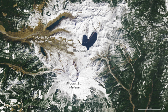
Mount St. Helens Isn't Where It Should Be. Scientists May Finally Know Why.
The Volcano is Responsible for the Deadliest Eruption in the U.S., Yet Many Mysteries Remain About the Closely Watched Peak, Including Why it Formed in the First Place.
— By Maya Wei-Haas | Graphics By Diana Marques | Published: May 18, 2020 | September Wednesday 25, 2024

The gaping crater of Mount Saint Helens, seen here on September 5, 2019, is a reminder of the deadly volcanic blast that rocked the Pacific Northwest 40 years ago. Photograph By Amanda Lucier, The New York Times Via Redux
The frosty volcanic peaks of the Pacific Northwest stand in a remarkably straight line, rising from the crumpled landscape east of Interstate 5. But one volcano is conspicuously out of place. More than 25 miles to the west of the other explosive peaks, in the southwest corner of Washington State, sits Mount St. Helens.
It’s been 40 years since Mount St. Helens famously roared to life, sending ash and gas 15 miles high, flattening 135 square miles of forest, and killing 57 people in the country’s deadliest eruption. Today, the volcano is still one of the most dangerous in the United States, and the most active of the Cascade Range.
Where all this firepower comes from, however, has been an enduring mystery. The volcano’s defiant position out of line perches it atop a zone of rock too cold to produce the magma necessary to feed its furious blasts.
“There shouldn’t be a volcano where Mount St. Helens is,” says Seth Moran, scientist-in-charge at the U.S. Geological Survey’s Cascades Volcano Observatory in Vancouver, Washington.
Solving this puzzle is about more than satisfying geologic curiosity. The firestorm 40 years ago was a reminder of the dangers the Cascade volcanoes pose to millions of people—and a hard shove propelling volcanology into the future. In the decades since, scientists have used the extensive observations of that blast to better understand eruptions around the world, and bolster our readiness for those yet to come.

© NGP, Content may not reflect National Geographic's current map policy. Source: USGS
“This was a fundamental leap forward in our understanding of this style of eruption,” says Janine Krippner, a volcanologist with Smithsonian’s Global Volcanism Program.
Crucially, a more detailed view of the volcano’s inner workings could help researchers better track the shudders and shifts that foreshadow an eruption, potentially helping to hone volcanic forecasts and get people out of harm’s way.
Four decades after Mount St. Helens’ eruption, scientists finally are unearthing some clues to its curious position. In one of the most comprehensive efforts to trace a volcano’s roots, the Imaging Magma Under St. Helens project, or iMUSH for short, used a slew of analyses to bring these subterranean secrets to light. Overall, the volcano doesn’t follow the textbook picture of a peak sitting above a chamber of molten rock. Instead, it seems, a diffuse cloud of partially molten blobs lingers deep below the surface, offset to the east of the edifice, toward the neighboring Mount Adams.

A column of searing ash and gas rises from Mount St. Helens on May 18, 1980, seen here from the southwest. Less than two weeks after the eruption, some of this volcanic ash had drifted all the way around the world. Photograph By Corbis Via Getty Images
View From The Sky
On the crisp, clear morning of May 18, 1980, geologists Dorothy and Keith Stoffel were soaking up glorious views of Mount St. Helens from the air. As a special treat for Dorothy’s upcoming 31st birthday, the pair had secured permission from the USGS to charter a flight over the volcano. It had been rumbling for nearly two months, but the mountain was almost tranquil early that Sunday. When Dorothy called the USGS to check if the flight was a go, she was told: “Come on over, there’s nothing happening here.”
Usually covered in snow and glaciers, Mount St. Helen’s white flanks had been blackened by the volcano’s recent burbles. The pair snapped pictures of the symmetrical peak from the windows of the Cessna 182. “It was so calm and serene, I almost felt a sense of disappointment,” Dorothy recalls. “In my mind, I thought, Oh, the mountain’s become dormant again.”
A swollen bulge that protruded from its northern flank was one of the few visual reminders of its active state. Since late March of that year, the bulge had grown six and a half feet each day. As the Stoffels flew by, Dorothy spotted glistening white tracks of melted ice rolling down the volcano’s ashen face, a sign of the intense heat just below the surface. The plane then looped across the sky, eventually making two passes over the volcano’s crater.
At 8:30 a.m., they decided to make one last arc heading east above the bulge. That was when the volcano suddenly unraveled.
Faster than they could comprehend what was happening, a crack more than a mile long split the mountain, and the north side collapsed in the largest landslide ever recorded above water. The pair continued snapping images as the ground seemed to liquify, and more than 0.6 cubic miles of material—enough to fill a million Olympic swimming pools—churned downslope.
“As a geologist, you expect volcanoes to erupt,” Dorothy says. “You do not expect mountains to instantly fall apart.”
“As A Geologist, You Expect Volcanoes To Erupt. You Do Not Expect Mountains To Instantly Fall Apart.”
— Dorothy Stoffel, Retired Geologist
The landslide released the pressure on the magma building below—like popping the cork of a champagne bottle—and the volcano let loose. Billowing clouds of hot rock jetted northward in a massive sideways blast, the first of its kind observed in detail. Traveling as fast as 300 miles an hour, the explosion sheared the peak off the volcano, and wreaked devastation across hundreds of square miles.
Swelling clouds from the sideways blast began to overtake the Stoffels’ plane. The pilot dropped into a nosedive to gain speed. “I really thought our lives were over,” Dorothy says. But by veering south, the trio narrowly escaped.
As they retreated, Dorothy watched the plume of searing gas and ash billow skyward, flashes of volcanic lightning illuminating the crater. For more than nine hours, the plume towered over the volcano, blanketing the region in ash and blotting out the sun.

A helicopter drops off equipment at Mount St. Helens to monitor for potential activity. The array of instruments that keep close watch on the volcano has undergone multiple upgrades since the 1980 eruption. Photograph By Adam Mosbrucker, USGS
The Stoffels’ harrowing account is a vital piece of information among the numerous observations of the explosive event recorded by both citizens and scientists. Nearly 34 miles to the east, on Mount Adams, climber John Christiansen, raised his ice ax to the sky. The air was so electric, it shocked him through his woolen mitten. Some 45 miles to the southwest, on Oregon’s Sauvie Island, artist Lucinda Parker and her husband tracked the roiling plume as their three-year-old daughter played in the sand. More than 145 miles to the east, Douglas Bird and his family were leaving for church when he spotted the approaching clouds laden with ash, unlike anything he’d seen before.
The power of the blast has echoed through generations and brought researchers from around the world to Washington State to study the volcano. The iMUSH project was, in part, born from this intense fascination.
Peering Into The Deep
Mount St. Helens is a member of the Cascadia volcanic arc, which stretches from British Columbia to Northern California. Similar to many volcanoes around the world, this simmering range is the product of a subduction zone, a tectonic collision where, in this case, a dense oceanic plate plunges beneath a more buoyant continental plate. As the slab descends, pressures and temperatures climb, and fluids percolate out of the slab, triggering the solid mantle rocks to melt. Less dense than its surroundings, this molten magma shoves its way upward through the crust, creating volcanoes.
Most of the Cascade volcanoes—and others around the world—take shape above the spots where the plunging slab descends to roughly 62 miles deep, where temperatures get high enough for magma to form. But the situation is different at Mount St. Helens. Standing tens of miles to the west of other volcanoes, the infamous peak perches a mere 42 miles above the subducting plate.
The iMUSH project kicked off in the summer of 2014 in part to try and solve this conundrum. To craft images of the subsurface, scientists can study the speed at which seismic waves travel and their path underground; it’s not unlike taking a planetary ultrasound. Battling flat tires and unmaintained dirt roads, dozens of researchers assembled to deploy a fleet of seismometers all over the volcano’s flanks.
“As Far As The Group Was Able To Do, The Kitchen Sink Got Thrown At St. Helens.”
— Seth Moran, USGS Cascades Volcano Observatory
For one part of the analysis, the researchers detonated a series of blasts and watched the waves roll in. Another set of instruments recorded every tremble around the peak—such as the rumble of ocean waves and earthquakes on the other side of the world—for two years. Other researchers tackled the system by studying the chemistry of the rocks themselves. And still more scientists used Earth’s magnetic and electric fields to map out the conductivity of the subsurface.
“As far as the group was able to do, the kitchen sink got thrown at St. Helens,” says the USGS’s Moran, who was part of the iMUSH team.
The results show that seismic waves creep along slowly in a zone east of Mount St. Helens, some 10 to 25 miles deep. Differences in minerals can influence the speed of seismic waves, but magma can be another source of this sluggishness. Perhaps rocks melt as expected near the rest of the Cascade volcanoes, the analysis suggests, but some diverts westward to squeeze through the subsurface and feed Mount St. Helens.
The story from the rocks themselves fits with this picture. By melting samples of erupted rock under a variety of conditions in the lab, the team revealed that the sticky gas-rich magmas that give Mount St. Helens eruptions their punch form at a depth similar to the proposed reservoir, says Dawnika Blatter, an experimental petrologist on the iMUSH team who works with the USGS’ California Volcano Observatory.
The surprising offset of this magma “suggests we need to look more broadly than just right below a volcano if we’re going to understand where the magma is coming from,” says Geoffrey Abers, a geophysicist at Cornell University who was part of the iMUSH seismic analyses.
After the 1980 eruption, researchers may have even caught trembles from nearby this deep melt zone, as the earth adjusted to the draining of molten rock. For nearly a year after the blast, Moran says, tremors rumbled to the southeast of the peak. Subterranean shifts in magma can produce quakes around volcanoes, so knowing whether these tremors are in fact linked to Mount St. Helens’ magma pockets could help direct future monitoring efforts.
“We’ve known that the southeastern side of St. Helens is a little bit of a weak spot in the network,” Moran says. “Having insight into reasons why earthquakes are occurring out there gives more impetus to improving that side of the volcano.”
Mount St. Helens Sits Oddly Apart From The Other Cascade Volcanoes.
Ancient scars in the subterranean landscape may explain its unusual position, directing magma along
an unexpected route.
Million years ago, tectonic plate collisions sent a plateau called Siletzia inching toward ancient North America.
62-56 Million Years Ago

As the ocean between the two landmas-ses closed, sediments from the seafloor were scraped into a heap beneath the surface and squeezed into stone. This process formed what’s known as meta-sedimentary rock.
50-44 Million Years Ago

Meta-sedimentary rock Sinking ocean crust: The metasedimentary rock may have created a weak zone in the crust that helped molten rock rise to the surface. Some 20 million years ago, a massive slug of such melt pushed its way through, crystallizing and solidifying as a batholith.
28-18 Million Years Ago.

Analyses of Mount St. Helens hint that today, the magma originates from a zone of partially molten rock to the east. The different properties of the Spirit Lake batholith and the surrounding meta-
sedimentary rocks may alter the region’s geologic stresses, guiding magma west-ward to the oddly offset volcano.
Present Day
Mt. Adams. Mt. St.Helens. Batholith Fluid Release Drives Melting of Mantle Rocks Subducting Oceanic Plate:

Diana Marques, National Geographic Staff. Source: Paul Bedrosian, USGS; Alan Levander, Rice University
Ancient Scars
The choreographer of this magmatic dance is still being debated. Many scientists see clues in the surrounding landscape, which bears scars from millions of years of tectonic jostling that could help direct the modern flow of molten rock.
A volcanic plateau known as Siletzia once sat off North America’s west coast. But Earth’s continuous tectonic shifting slowly closed the gap, and some 50 million years ago, Siletzia collided with the continent. As the ocean between the two landmasses closed, seafloor sediments were scraped into a heap beneath the surface and squeezed into stone. According to the iMUSH team, this indelible tectonic suture may lie just beneath Mount St. Helens.
The scientists sketched out structures from this merger using a method known as Magnetotellurics, which tracks the conductivity of rocks. Minerals that are carbon- and sulfur-rich, similar to those that might form from marine sediments, “light up like a Christmas tree,” says Paul Bedrosian, a geophysicist with the USGS and a member of the iMUSH team. Sure enough, just beneath Mount St. Helens, a swath of such illumination marks the region where ancient marine sediments were turned into a particular rock type called metasedimentary.
The analysis unveiled another surprise just to the east of the volcano: A vast area of low-conductivity rock sits just above where deep magma may pond. The scientists believe this rock is a slug of now-cooled magma that formed millions of years before Mount St. Helens was born.
The differences in the properties of this volcanic plug, known as a batholith, and the metasedimentary rocks of the suture zone may alter the stresses in the region and thus direct the magma flow. The batholith limits magma from rising to the east of Mount St. Helens; the metasedimentary rocks could serve as a relief valve, drawing the volcano’s sticky, viscous magma to the surface.
A dense wall of rock beneath these metasediments, also revealed by the seismic array, may actually be part of this lost landscape, providing a westward stop for the flow of magma, says Jade Crosbie, a geophysicist with the USGS in Lakewood, Colorado, and part of the iMUSH team.
Navigating a Sea of Data
While the iMUSH analyses help sharpen our view deep inside the planet, the picture remains far from complete, Moran says. “One of the general rules in geophysical imaging is the deeper you go, the less you know.”
youtube
VOLCANOES 101. About 1,500 active volcanoes can be found around the world. Learn about the major types of volcanoes, the geological process behind eruptions, and where the most destructive volcanic eruption ever witnessed occurred.
Today, the remains of Siletzia can be seen only piecemeal at the surface, partially buried by flows of now solidified lava and soils studded with trees. This leaves scientists debating where the suture zone—and its role in magmatic direction—precisely lies. To actually put your hand on Siletzia rocks, you’d have to travel tens of miles to the west of Mount St. Helens, says seismologist Eric Kiser of the University of Arizona, who was an iMUSH team member.
As the researchers continue to sort through the sea of other data from iMUSH, many more questions dance in their heads. How does the system change over time? How quickly does the magma move? How does such a vast zone of partly melted rock focus into a volcanic pinprick on the surface? Each potential answer helps shape our understanding of how and why volcanoes erupt, which can help researchers connect what happens at one volcano to the broader picture of volcanism around the world, says seismologist Helen Janiszewski of the University of Hawaii at Manoa.
Since that fateful day in 1980, Mount St. Helens has awoken multiple times, even as the population living in its shadow has grown. That confluence reinforces the need to keep close watch on this particular peak, and scientists have embraced that task.
“Mount St. Helens is being monitored really well,” Kiser says. “The USGS people, they’ve got that under control.”
#Youtube#Geology#Volcanoes 🌋#Natural Disasters#Mount St. Helens#Scientists#United States 🇺🇸#Maya Wei-Haas#Graphics | Diana Marques#Deadliest Eruptions#Vocanoes Mysteries
0 notes
Text
Possible Hypersonic Missile Strike Near Bremerton Naval Base in Washington State
Bremerton Naval Base Hal Turner The United States Geological Survey reports an “Other Event” caused the equivalent of a Magnitude 2.6 earthquake, 0.8 km ABOVE ground at 09:12 UTC this morning. Word is this “Other Event” was . . . . an explosion – possibly of a Hypersonic missile –sent as “a message” to the […]
Possible Hypersonic Missile Strike Near Bremerton Naval Base in Washington State

View On WordPress
0 notes
Text
Possible Hypersonic Missile Strike Near Bremerton Naval Base in Washington State
Hal Turner
The United States Geological Survey reports an “Other Event” caused the equivalent of a Magnitude 2.7 earthquake, 0.8 km ABOVE ground at 09:12 UTC this morning. Word is this “Other Event” was . . . . an explosion – possibly of a Hypersonic missile –sent as “a message” to the Untied States.
Above is a screen shot of the USGS website reporting this “Other Event.”
If this “Other Event”…

View On WordPress
0 notes
Text
The U.S. just took its biggest step yet to end coal mining. (Washington Post)
In one of its biggest steps yet to keep fossil fuels in the ground, the Biden administration announced Thursday that it will end newcoal leasing in the Powder River Basin, which produces nearly half the coal in the United States.
Climate activists have long pushed the Interior Department to stop auctioning off leases for coal mining on public lands, and they celebrated the decision. It could prevent billions of tons of coal from being extracted from more than 13 million acres across Montana and Wyoming, with major implications for U.S. climate goals.
A significant share of the nation’s fossil fuels come from federal lands and waters. The extraction and combustion of these fuels accounted for nearly a quarter of U.S. carbon dioxide emissions between 2005 and 2014, according to a study by the U.S. Geological Survey.
In a final environmental impact statement released Thursday, Interior’s Bureau of Land Management found that continued coal leasing in the Powder River Basin would have adverse effects on the climate and public health. The bureau determined that no future coal leasing should happen in the basin, and it estimated that coal mining in the Wyoming portion of the region would end by 2041.
Last year, the Powder River Basin generated 251.9 million tons of coal, accounting for nearly 44 percent of all coal produced in the United States. Under the bureau’s determination, the 14 active coal mines in the Powder River Basin can continue operating on lands they have already leased, but they cannot expand onto other public lands in the region.
The decision drew praise from climate advocates who have fought for years to restore an Obama-era moratorium on coal mining on federal lands.
But the move angered Republican lawmakers in Montana and Wyoming, some of whom accused Biden of waging a “war” on coal, even as the nation moves away from the fossil fuel because of market forces.
The move also infuriated mining groups, which have argued that the nation needs more — not less — fossil fuels to meet explosive energy demand fueled by electricity-hungry data centers and manufacturing facilities.
The United States is already moving away from coal, which has struggled to compete economically with cheaper gas and renewable energy. U.S. coal output tumbled 36 percent from 2015 to 2023, according to the Energy Information Administration. The Sierra Club’s Beyond Coal campaign contends that 382 coal-fired power plants have closed down or proposed to retire, with 148 remaining.
5 notes
·
View notes
Text
Hydrothermal explosion causes damage in area of Yellowstone National Park • Washington State Standard
A hydrothermal explosion in Yellowstone Nationwide Park broken a boardwalk and despatched particles a number of tales into the air Tuesday morning within the Biscuit Basin space northwest of Previous Devoted, based on the scientist-in-charge on the U.S. Geological Survey’s Yellowstone Volcano Observatory.
The explosion, which Scientist-in-Cost Michael Poland stated was a “small” one, occurred…
0 notes
Last Seen Blogs

aintjesusperiod
Untitled

jenfuu
my corner

legendaryobservationcrusade
Legendary Observation Crusade

thepoizon
So krypt gang

knittingpirate
Life and Times of a Knitting Pirate