
This is a journal of our attempt to section hike the Appalachian Trail. Progress: 278.3 of 2,184 miles
Don't wanna be here? Send us removal request.
Statistics
We looked inside some of the posts by athike and here's what we found interesting.
Average Info
Notes Per Post
9
Likes Per Post
9
Reblog Per Post
0
Reply Per Post
0
Time Between Posts
1 year
Number of Posts By Type
Text
9
Last Seen Tumblr Blogs


Fun Fact
The Tumblr office adopted Tommy, an 11-year-old Pomeranian.
Text
Section 9 - Recalibrating
(Date) N/A Carver’s Gap, TN to US19E, NC Distance: 15.0 miles
We added the 15 miles between Carver Gap and US 19E to our list because we have done that section so many times over the years. And Yes, to be honest, because we have not made any progress in years.
We are not ready to restart but I have been meaning to update our progresses so we know where to start if/when we ever restart this adventure.
Current miles: 278.3 miles
Gaps to fill in:
Dam Visitor Center (166.1) to Clingman’s parking (198.6) : 32.5 miles
Log Cabin Drive (290.2) to Hughes Gap, TN (371.3) : 81.1 miles
If we make it to Damascus that would be 467 miles and 20% done.

0 notes
Text
Section 8 - It can be boring
October 9th, 2015 Stecoah Gap, NC to Fontana Dam Distance: 15.4 miles
The plan was to slack pack from Stecoah Gap to Fontana Dam and then the next day go to the top the Smokeys and hike back to Fontana Dam over the next 3 days. You know what they say about plans....
The day started with a shuttle ride to Stecoah Gap where the driver casually said “Wow, hiking 15 miles on the first day, that is pretty tough”. Dave and I thought it could not be that tough since we were not hauling full gear. And so the same story plays out over and over again......

We thought the hardest part of the hike would be getting over Jacob’s Ladder, but an hour in we were at the Brown Fork Gap shelter and past Jacob’s Ladder and we figured we were on our way.
The thing about this section of the trail is that there is literally nothing to see, but trees. We had heard/read that you have to be ready for these types of sections because it is about just powering through. 4 hours into the hike Dave and I started talking about how flipping boring this was. 5 hours in we started openly asking “What are we doing!” (never a good sign) and 6 hours in we decided this whole hiking the whole AT was probably a horrible idea.
We hiked pass the Fontana Hilton and that section was pretty and right next to the lake.
We got in the car and canceled the next day’s hike. We decided that it might be best to re-think this AT end-to-end hike. We both love hiking, but find ourselves hating LARGE sections of this damn trail. We discussed a new plan of just hitting the highlights of the trial. The thing is the 2nd half of the Smokeys, which we just canceled, is one of the better parts of the trail. Our shuttle driver that morning was going on and on about it.
Fast forward 5 months, and we our set up to do the section we canceled after this hike. We are still telling ourselves we are only doing the best sections of the AT, but if we get this section done and them the small sections we need to do to fill in the areas we jumped over earlier then we will be at Carver’s Gap. Carver’s Gap to 19E is my absolute favorite section of the trail, at least the sections that I have experienced, and then you never know.....

0 notes
Text
Section 7 - Hiking Itch
April 18th, 2015 Hughes Gap, TN to Carver’s Gap Distance: 3.6 miles + 2 miles (previous)
Well it has almost been a year since our disastrous Smokey Mountain hike back in June. Dave and I were up at the cabin doing some maintenance and we started talking about getting back on the trail. We figured we would do a day hike with no backpacks and see how it went.
We left from Hughes Gap at around 9am. Hughes Gap is only a few miles from the cabin and a few times we could practically see the cabin from the trail.

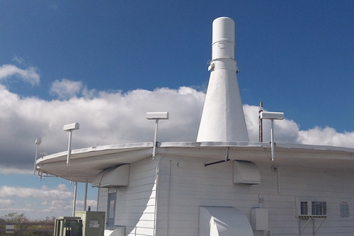
It was a nice hike up to the Roan High Bluff where everyone goes to see the rhododendrons during the big summer festival. We have been there a bunch of times, but this is the first time I have hiked up from this side.

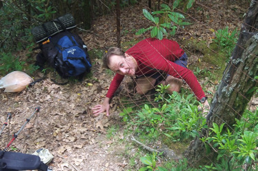
At one point the trail sort of opened up (see above) and it was really beautiful. We even saw what looked like a personal helicopter that flew over us. The darn helicopter sounded like it could barely make it over the mountains so I was sure we were going to hear about some crash landing or something, but we never did.
We got to the top and we felt great. We then hiked back down to the car. One funny thing that happened was that as we were approaching Hughes Gap, where we parked the car, we noticed a bunch of cars and some tents. Apparently there was some sort of fund raiser going on that day, which explained all the people we saw on the trail. Anyway when we approached the gap I think they thought we were part of the hikers raising money for their event so all these people start clapping. I said to Dave, “They don’t think we are with them do we?”. Then as we get closer the people start yelling and cheering and that is when it got awkward. We had to basically tell them to kill the band and the clapping we were not with their group. Literally we have a story with everyone of these darn hikes!

{Note: We decided to add the mileage from the top of Roan High Bluff to Carvers Gap to our total distance since Dave and I have hiked that section 100′s of times, plus it makes it easier for us when we get back on the trail in this area.}
0 notes
Text
Section 6 - Another Brutal Learning Lesson
June 14-16th, 2014 Clingmans Dome, NC to Davenport Gap, NC Distance: 39.5 miles
Where do I start? The hurt knee? The lack of an ability to eat? Throwing up on the trail (how does that work)? Brutal..... Probably the reason I waited over a year to write about it. Since we are weeks away from “rebooting” this adventure AGAIN, I thought I should get caught up on my posts.
Even with all the “lessons” the Smokey Mountains provided, this place was every bit as beautiful as we had hoped. We knew that this section was going to be tough since we had to pre-determine how far to go each day and align that with the availability of hiker huts. One requirement of the Smokey’s is that they want you to stay in hiker huts and not just set up camp anywhere. Due to this we were looking a 10 mile hike the first day(which was not bad), and a 20 mile hike for the next day (which was bad). The guy who shuttled us to Clingmans Dome definitely raised an eyebrow when we told him about day 2.

Day 1 was beautiful and cool at 58 degrees. Everything was really lush and green. We reached Newfound Gap at around 3pm. It was 4 hours after we started and it was a good place to stop and rest. There were a bunch of tourist walking around and enjoying the view. Dave’s knee was hurting him a bit, but we have both had that happen to us at the very beginning of these trips so we just rested longer than usual and started back on the trail.

We reached Icewater Spring Shelter at around 5:22pm. We were greeted by multiple signs warning of bears. I had read the Smokey Mountains had the most dense population of bears on the AT, so I was really hoping that we would actually finally see a bear. Dave’s knee was still hurting but we figured he could sleep it off and we would be ready for the big 20 mile day the next morning.
Day 2 started at 7:30 am. We knew we had 20 miles to go and so we were looking at a 10 hr day, at least. Dave’s knee was still really sore, but we thought it might loosen up as the morning went on. It never did. He was in extreme pain with the knee all day. When we stopped for lunch I was not hungry but I knew I had to eat because I was not feeling well. I then proceed to throw up everything I ate. It was a gross as it sounds, but I did feel way better so I figured it was a one time deal. At around 7:30 pm, and 12 HOURS!!! into the hike, we came across some plane wreckage near the Snake Den Ridge Trail (who comes up with these names!). I did some research and apparently an F-4 Phantom military jet crashed into the mountain in 1984. The wreckage is all over the side of the mountain.

At this point we are about 4 miles from Cosby Knob Shelter. Four miles is not that bad, unless you are not eating, have a bad knee, you have been hiking for 12 hours already, or all of the above. Eventually it started getting dark on us and since we are not suppose to stay anywhere but in designated hiker huts we had to push on with headlamps. Around 9:30pm we were both exhausted and literally every step Dave took felt like a dagger going through his knee. So we just said the heck with it we are going to roll out the sleeping bags in the middle of the woods and just take our chances that we are not bothered by any of the wild life. We laid down in our sleeping bags and not 3 minutes later we start hearing rain. We just laid there not saying anything to each other. Neither of us could believe our luck. Not a single drop of rain all day and now this. Eventually one of us spoke up and was like “I guess we have to get going?”. We packed up and started hiking, again. Earlier I had been banging two sticks together so that we were making plenty of noise because we did not want to startle a bear. I had long since stopped that because I was to exhausted to do anything but walk. I then came over the top of this ridge and started hiking down. I saw in the distance the eyes of what I thought was an owl in a tree. As I approached I realized it was really a huge bear walking down the trail, in the same direction we needed to go. After I got back to Dave an explained the problem, we stood there in the rain trying to figure out what to do. Again we had to keep going, so we did. Luckily the bear left the trail and we were able to get through. We arrived at Cosby Knob Shelter at around 10:30 pm, 16 hours after we had started our day. Of course the shelter is full of sleeping hikers of which none seemed to have any of the tree hugger/hippy love you normally run into. In fact some lady yelled at us “Do you know what time it it?”, it was like “Yeah, we are painfully aware what time it is!”. We got up in the morning and some of the hiker were a bit nicer, especially after hearing about our previous day.
Day 3 started at around 7:30am. Dave’s knee was no better and I had not eaten or drank that much in over 24 hours. We had 8 miles to get back to the car. About a half mile into the hike, I did some quick math and realized that at that pace we were having to travel, because of Dave’s hurt knee, it was going to be ANOTHER 8 hour day. At this point I realized I was not going to eat or drink another thing out of my pack and I could not go another day with out food and water. I took some of Dave’s equipment from his pack and put it into mine and told him I would meet him at the car. I figured I could cover the rest of the miles much quicker then Dave. Plus by the time he made it to the car I could run into town and get real food and Gatorade for us both. So at Low Gap, we said farewell.

The funny thing is that for the next hour or two he kept catching up with me. I would say goodbye and then shoot ahead and then the next thing I know I would hear him coming around the bend.
Later he did have his own bear experience. He was on part of the trail that hugged a ridge line and there was a beautiful overlook. He said he was standing there looking around and a bear ran out of the woods. They both were startled and it ran away. He said it was a good thing because there was not much room for him to go anywhere, plus he was so hobbled there would have been no running.
I made good time back to the car, throwing up again on the way. When I did make it to the car, I went to the nearest convenient store and picked up a bunch of 32oz Gatorades and some subs. Once I drank the first 32 oz Gatorade I slowly started getting back my appetite. About an hour later I ate my sub and then I was halfway through my second 32oz Gatorade when I found Dave exiting the trail. A family was there and the mother has a nurse who looked at Dave’s leg and told him she did not think there was any serious damage.
We thew his junk in the car and headed back to cabin to recover. At that point we we had decided to take a nice long break from this great adventure.
(I apologize to anyone that stumbled on to this blog looking for inspiration to hike the AT.)
1 note
·
View note
Text
Section 5 - To Far and Not Hungry
October 10-12,2013 Davenport Gap, NC to Log Cabin Drive, NC Distance: 52.1 miles
Well we had planned on starting the Smoky Mountains on this trip, but due to the government shutdown we had to jump past the smokies and start at Davenport Gap.
Day 1 was nice. The weather was cool and perfect. The hiking was really good. By 2 p.m. we had climbed 2,800 ft to the top of Snowbird Mountain. On the way up to the summit we ran into a guy from England who was headed south. He warned us that he had walked up on a big black bear which was blocking the trail. I told him we had yet to see a bear and that I was hoping to spot it, but he made it clear that he did not want to see another one. So with my camera in the ready we continued up the trail. We of course did not see any bears. I am not sure what the deal is, maybe it is luck, but we continually run into people that tell us of bear sightings only never to see one ourselves.
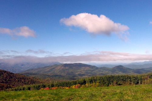
At the top of Snowbird Mountain we got our first excellent view of the trip, plus we saw this strange building on top that we we believe was some sort of FAA radar station.
We ended day 1 by setting up our tents in the woods between Brown Gap and Cherry Creek Trail. We put in 12.9 miles for the day. We had a good meal that night. I put my self through the extra torture of carrying shells and cheese, which is nearly a pound by itself, and Dave and I both cooked up bacon before we left the cabin that morning so we ate like kings.
Day 2 started with us reaching Max Patch Summit. The view on top of that bald were absolutely gorgeous.
We hung out on the bald for an hour just relaxing and enjoying the view. We then put another 10 or so miles on the trail and stopped for lunch around 2pm. Unfortunately I was not hungry at all, even though I had only had a light breakfast. I continue to struggle with my appetite on these trips. I don't know what the deal is, but no matter what I bring to eat is just does not seem appealing to me by the second day. I think I ate 1/2 of a breakfast bar at that stop. That night we finally reached Deer Park Mountain Shelter around 7pm, we had walked about 20.5 miles at that point which is a long day. BUTTTTTTT... As we sat there and caught our breath the conversation turned to Hot Springs, NC which was ONLY 2.4 miles away.
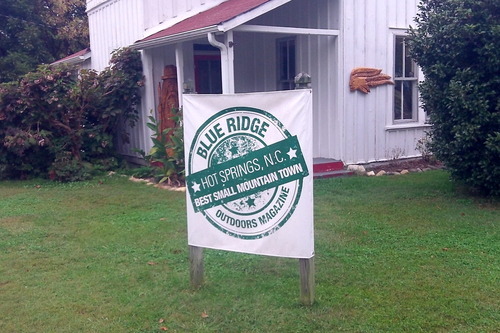
Then we started talking about what we would eat for breakfast there the next day. I am not sure if it was Dave or I who first dared to mention the idea of hiking the additional 2.4 miles that night. The thought of sleeping in a bed was overwhelming, as was eating a hot meal. I personally knew that if we did not hike to a restaurant that night I would not being eating dinner because my appetitive had still not returned. So we strapped our lights on our heads and went on. I have to admit it was a bit freaky hiking at night, plus for part of the way we were walking along the ridge line which dropped off. We arrived in Hot Springs at 8:15pm and after 20 tense minutes we literally found the last hotel room in town. Magically my appetite returned and we ate a hot meal and we were in bed by 10 pm. We hiked 22.9 miles that day, our biggest mileage day yet (to put that in perspective we hiked 22.2 miles in two days during our disastrous Section 1 hike when we had to bail out early due to exhaustion).
Day 3 we woke up in Hot Spring rested. We went and had breakfast and looked forward to a good day of hiking. Hot Springs is great little town, though it is much smaller then I thought it would be. On our way out of town we passed a small resort, which was on the largest and flattest land in the whole valley. It apparently had once been used as a German internment camp in World War I, which seems inconceivable.
As soon as we left Hot Springs we started climbing up the mountains again. Dave and I were both dragging all day. I thought for sure since we had slept in beds and had a good hot dinner and breakfast that the long 22.9 mile day we had done the day before would not have had a detrimental effect on us. That did not seem to be the case. Through out the day we had to stop a lot and take longer breaks then usual. We did make it back to the car at 6 p.m., which was 1/2 day ahead of schedule, but at that point we both came to the conclusion that we had gone to far the previous day. That 3rd and final day was all work.
This section of the trail was beautiful, but I need to figure out this appetite problem. I plan on reaching out to some fellow AT hikers to see what, if anything, can be done about this. I obviously can not burn that much energy and not refuel. I am totally at a lost at why I am loosing my appetite on these trips. Hopefully I will have a solution by the time we go out again.
0 notes
Text
Section 4 - Lost and still learning
June 1-3,2013 Wayah Gap, NC to Stecoah Gap, NC Distance: 35.0 miles
We started at Wayah Gap, NC at 10:30 am on Friday June 1st. It was 65 degrees.
At about 1:45 pm, just past the Wayah Bald stone tower, Dave and I began to suspect we had made a wrong turn. The trail started to become uncharacteristically over grown.
We realized that we had not seen a trail blaze for almost an hour. We kept hiking in hopes of seeing a landmark. We never did. We eventually walked up on an area that had been fenced off. On the other side of the fence we saw a really deep ravine that lead back into the mountain. We climbed under the fence and took a look. I took some video of this deep ravine and cave, but the video do not do the place justice. We then saw a trail leading down to the entrance of the ravine. But before we headed down the trail to explore it we made mistake number two. I decided to check my phone and luckily we had cell service and I was able to bring up Google Maps and I saw that we were way off course (Thank you Google!). So instead of taking the time to turn this mistake (going way off the trial) into a cool side adventure (by hiking down and exploring this ravine and cave) we grabbed our gear and headed back to the AT intent on getting our miles in for the day. That detour cost us 3 additional miles, but our biggest regret was not taking the time to explore that area. AT hikers often get obsessed with getting their miles in and sometimes we forget that this is suppose to be fun. We made that mistake. Lesson learned.
That afternoon we ended up stopping around 5:15 pm at the Cold Spring Shelter. We had knocked out 9.9 miles of the trail that first day, which was actually 12.9 miles of hiking for us. That night we meet a couple of guys from Florida who were section hiking the trail and a kid just out of college who was thru-hiking. I am pretty sure that over 50% of the people we talk to on the trail are from Florida. It is interesting that some many Floridians are out there.
That evening it rain horribly and it was still raining the next morning when we got up. Dave and I were so glad that we had stayed in the shelter and our gear was dry. The hiking gear is heavy enough dry, but a wet tent and gear is even heavier. Dave and I left that morning in the rain in hopes that it would clear up.
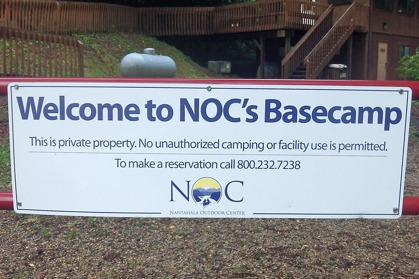
It did clear up for a while but then the rain and lighting came back with a vengeance. Luckily for us we were hiking towards the Nantahala Outdoor Center which held promise of hot food and cold beer. Unluckily for us, our judgement of distance seemed to be way off that day. It is really disheartening when you trick your brain and body to walk just a little further with the promise of salvation around the next bend only to see more trees around each bend. At one point one of the guys from Florida caught up with us and ask how far it was until the N.O.C. We were so frustrated by this point, I just barked back "WE SERIOUSLY HAVE NO IDEA!!!". Even though our map seemed to show it was less then a mile away, we were so tired of being burned that we did not trust the map or the sick deviant that had created it. By the time we finally got to the N.O.C. at around 2:20 pm we were wet and exhausted. We had only hiked 11.7 miles that day and our original plan was to go another 3 or 4 miles after eating lunch. Once we had our first cold beer, the decision was made. We were staying put!

The next morning we left early knowing we had 3,500 ft climb up the mountain and back down the other side. It was very tough climbing. By the time we were about an hour away from Stecoah Gap, Dave and I were both nursing sore knees and we knew we had the notorious "Jacob's Ladder" ahead of us. Reluctantly we decided to call the trip early. With a total of only 35 miles under our belt we bailed out.
This trip was yet another learning experience for us. For one, we definitely are not going to pass up future opportunities to explore just to get our "goal" miles in for the day. We also need to do a better job of planning our hikes and understanding the sections which are tougher then the others. Trying to average 13-15 miles a day regardless of the terrain is not going to work.
The Smokey Mountains are rapidly approaching. I can't wait to see what happens next.
1 note
·
View note
Text
Section 3 - Goodbye Georgia
October 18-21,2012 Dicks Creek Gap, GA to Wayah Gap, NC Distance: 46.1 miles
We started at Dicks Creek Gap, GA at 9:30 am it was around 55 degrees. It was very foggy when we started off but is was suppose to clear up. We got to Plum Orchard Gap at around 12 pm and the hiking was really moderate. At 1:30 pm the fog had actually gotten worse (somehow), but at that point we were glad not to be hiking in the direct sun light.

We made it to the Georgia/North Carolina border at 2:30 pm that day. I was looking forward to this milestone since it meant we would be crossing off our first state and I have been looking forward to getting into North Carolina. We ended up camping a few hundred feet from the border at Bly Gap. It was just after 2:45 pm and we had only done 9 miles of moderate to light hiking but my knee was killing me. We learned our lesson from our first section hike where we pushed it way past our limits on the first day and were ruined for the rest of the trip. I was really concerned about my knee since this was only the first day and again it was really not that strenuous.
It was absolutely freezing that night in the gap. I am not sure if it was because we were down in an impression in the mountain or what, but I could not get warm all night. We left Bly Gap at 8:30 am on Friday (October 19th) and my knee was slightly better but I was still limping. This part of the trail does not have many places where you can easily bail out so I was a bit on edge. We also had nearly a 1,000 ft climb to do right out of the gate. The odd thing was that after 15 minute of hiking my knee pain went away and I did not have a single problem for the rest of the trip. Dave and I were both grateful that we had had the common sense to stop early the day before and we did not have a repeat performance of our section 1 trip.
We hiked 15.3 miles on Friday and we stayed at Carter Gap Shelter in a hiker hut. It was another good experience of staying in a hut. There was an older gentlemen who was southbound and was about to finish the AT after section hiking the trail over many years, like Dave and I will be doing. There was also this extended family from Florida who had set-up tents and were up for a few days of hiking. It was nice to have some people to talk to.
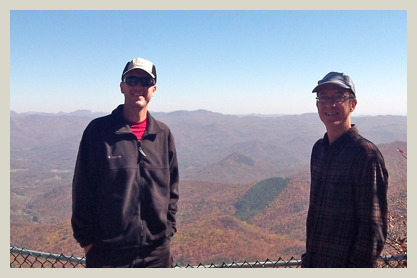
We left the Carter Gap Shelter on Saturday at 8:30 am. We made it to the base of Albert mountain at around 12 pm. We then literally went straight up. This section was more of a climb then a hike. Having that extra weight strapped to our backs made it extremely challenging. Once we got to the top the view was absolutely beautiful. There is a fire tower at the top of Albert mountain which you can climb up and view mountains in every direction for miles.
We ended up hiking 16.2 miles on Saturday, which was a long tiring day. It was after 6 pm when we decided to stop about a 1/2 mile past the Winding Stair Gap and 5.8 miles past our planned stopping point at Rock Gap Shelter. It seems like after that first day you really start to get your legs, but having said that we were both really exhausted. I made myself eat, though neither of us were very hungry, and Dave and I went fast to sleep.
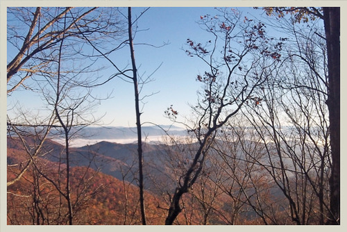
We got up a little after 6:00 am on Sunday (October 21st) and by 7:00 am, in the dark, we were back on trail with our lights in hand. The sunrise over the mountain was beautiful and the pictures and video that we took did not give it justice. This time of year was so beautiful because of the color changes in the leaves.
We arrived back to the car in Wayah Gap at 9:30 am which was way earlier than we had planned but we had hiked so far the previous day that we did not have much hiking left to do.
This was an uneventful trip, which was nice. I can't wait to see what North Carolina has in store for us.
0 notes
Text
Section 2 - Now we are rolling!
May 5-8, 2012 Woody Gap,GA to Dicks Creek Gap, GA Distance: 48.4 miles
Dave and I started our 2nd section of the AT at Woody Gap, GA at 8:45 am on Saturday morning. The weather was cool and it was a beautiful morning. We were each carrying 20 lbs. less gear than last time.

I believe we were both a little anxious, because we knew that this trip needed to be a good one. Otherwise I think we would have had to scrap the whole idea of section hiking the AT.
We arrived at Blood Mountain shelter, our planned destination for the day, at 2:00 pm. The plan was to stay there for the night and resist the urge to go any further. We did not want to have a repeat of section 1 where we hiked to far the first day and then ended up to sore to go any further. We sat around the shelter and talked to some day hikers, took pictures, and then we had nothing else to do. So we picked up the gear and started hiking again.
We ended the first day of hiking at Flatrock Gap, which put us at 9.4 miles of hiking. We set-up camp and cooked ourselves a hot meal. After dinner we gathered all of the food, cooking utensils, and anything a bear might want and put it into bags. We then hiked into the woods, away from the campsite, to hang our bear bags.
Hanging a bear bag is should be straight forward. You take a rock and tie it to your line and then throw the rock over a high branch and pull your stuff up the tree. As I was getting ready to throw our rock and line I noticed that someone else had been there before us. Their rock and line had wrapped around a nearby branch multiple times and they had to the cut the line to free it. I decided that I was not going to let that happen to our line. I heaved the rock up and over the branch and sat there while the momentum of the throw caused the rock to wrap, wrap, and wrap around the branch. In an attempt to stop it and hopefully free the line I yanked down on the line. This did nothing, I thought. Dave and I turned to each other to figure out who had the knife so that we could cut the line and then all of a sudden the rock came flying past our heads. Apparently when I yanked the line it changed the momentum of the rock, causing it to unwind from the branch. The rock then came off the branch like a sling shot right at our heads. After a nervous laugh and some discussion about how much that would have hurt if it had hit one of us, we got the bear bag hung. Other than the near shot to the head with a rock, we had a good night and no visitors!
Sunday morning we got up and we ended up at Mountain Crossing at Neels Gap at 8:45 am. Mountain Crossing is a well known hikers hostel and outfitter on the trail. It was also featured in a National Geographic's special about the AT that Dave and I both saw on Netflix. We were both looking forward to seeing this place for real. The funny thing is at this point we had only been on the trail for 24 hours but we both consumed a Gatorade and a Snickers bar like we had been abandoned on an island for a month.
Sunday night we stayed at Low Gap Shelter. We put in 12.6 miles that day, which was a long day of hiking. Instead of staying in our tents we decided to stay in the shelter, which is just an open air structure with 3 sides and a roof. Sleeping in the shelter was not bad though I must admit that it was a little odd sleeping next to 3 other people we did not know. The up side to staying at a shelter is that you get to interact with people. We meet a guy from Germany, a couple celebrating their 10th wedding anniversary and another guy that was thru-hiking the trail for the 3rd TIME! The highlight or lowlight of the evening went to Dave. Dave had our first memorable wild life experience so far. He walked down to a small creek to fill up his water bottle and ended up right next to a big rattlesnake. He said he crouched down next to the stream and then he heard some strange noise and thought "that sort of sounds like a rattle". He looked up and a few feet away on the other side of the stream was a fat rattlesnake who I think was as surprised as Dave that he did not see him sitting there. Needless to say after that experience Dave and I were on high snake alert.
Monday morning we got up early and headed out. By 10:15 am we were at Chattahoochee Gap and we knew we were going to be back to Unicoi Gap and the car in a couple of hours. That put us back to our planned ending point a day early. We kicked around our options, which included just checking into a hotel and relaxing for the night or extending the trip. We decided to extend the trip which would add another 16.7 miles to this section. The big challenge would be getting to the next hikers' hut from Unicoi Gap by night fall.

The thru-hiker we meet the night before told us that after Unicoi Gap there were two 1,000 ft climbs. So when we got to Unicoi Gap, we drove the car to Dicks Creek Gap, and got a ride back. Of course as we were riding back in the shuttle it started raining. As we got out of the car at 2:30 pm it was raining heavily. Dave gave me a look, and with out saying anything I knew we were thinking the same thing. "We could be in a dry hotel room right now with cold beers in our hands" instead we had the bright idea to extending this trip.
The section between Unicoi Gap and Tray Mountain Shelter was really beautiful. I think it was one of my favorite areas so far. The only potential issue was that Dave and I decided to ditch our tents and cooking supplies back in the truck at Dick's Creek Gap to get even lighter to make those big climbs, but that meant if the shelter was full we would be sleeping outside in the rain. When we got to Tray Mountain shelter that evening it was nearly full. Lucky for us there was two spots left.
The next day we were on the trail at dawn and we covered the 11 remaining miles in great time. This put us back at Dick's Creek and the truck at 12pm. We then proceeded to drive as fast as we could to the first buffet place we could find. I really can't remember Western Sizzilin ever tasting so great!
With a good trip under our belt. I am excited to continue this adventure and I can not wait to hit the trail again.
2 notes
·
View notes
Text
Section 1 - Lessons, Loads, and Locals
February 22-23, 2012 Springer Mountain to Woody Gap Distance: 22.2 miles
We set off on the trail on Thursday morning, it was in the 40's, and once we got moving it temperature was perfect. I had read that you should really plan a light first day (5-6 miles) to get your body acclimated to the carrying heavy packs up and down the mountains.
That did not stop Dave and I from doing 13.4 miles the first day over really intense terrain all while carrying over 40+ lbs (we later discovered that I had 44 lbs and Dave had 47 lbs).
We ended up camping in Cooper Gap the first night. We were a concerned that the site was near a dirt road, but we were so exhausted by that point we decided to look past that concern. There was another hiker who followed us down into the gap because she thought it would be safer in numbers. The 3 of of us set up our tents about 25 yards apart. The other hiker made a comment when we were setting up that she did not like camping near a dirt road either but she figured since there were 3 tents the locals probably would not bother us. I did not think much of her statement, because I figured "what are the chances" someone would be up this way. Well at about 1:30 am that night we learned what the chances were. I woke up to rain and our tents completely lit up. I turned on my flashlight and looked out of my tent to see what was going on. I realized a truck was sitting on the road with it's lights on us. I turned off my flash light and waited. After about 5 minutes the guy(s) in the truck decided to amp up the intrigue and began to play heavy metal music. Then the thought crossed my mind that this person could run us over while we were in our tents and that I was first in line. So after a few more tense minutes the truck slowly drove off. Needless to say, I did not sleep at all that night. Dave on the other hand told me the next morning that he was so tired that he just went to sleep and figured if the truck was going to run him over then he might as well be a sleep. Considering how tired I was the next morning his logic made a lot of sense.
The next day of hiking was relatively easy, other then in the morning when we had to get over Justus Mountain. The problem was that after the previous day we were really spent. In the early afternoon Dave and I realized that once we passed Woody Gap (about 3 hours away) that there would not be another place to bail out for another day and half. I think we both initially resisted bringing up the option of quitting early, but it soon was unavoidable. We were totally spent from the first day of hiking and carrying to much weight. So we VERY reluctantly admitted that stopping at Woody Gap would be the best idea.
Lessons Learned:
We do not need nearly as much food as we thought. I brought dehydrated food for lunch and dinner for 4 days, a box of oatmeal pies, a box of peanut butter crackers, and trail mix (which was 1 1/2 lbs by itself). I had this fear that Dave and I would end up in the woods starving and being forced to go cannibal on someone. Come to find out it is common for your appetite is be greatly suppressed the fist 2 days of intense hiking on the trial, so we need to keep that in mind next time.
We need to be merciless with getting our packs down in weight. Weight matters, a whole bunch, especially after the first 2-3 hours when the adrenaline and excitement has left you.
Do not camp near places with easy access to the non-hikers, for example dirt roads.
In the end we had a good time and after a few weeks of recovery we are now itching to get back on the AT. I look forward to posting about the success of section 2, or Dave and I will be finding a new hobby.
5 notes
·
View notes