
Don't wanna be here? Send us removal request.
Statistics
We looked inside some of the posts by davila-c-sci-1-module3 and here's what we found interesting.
Average Info
Notes Per Post
0
Likes Per Post
0
Reblog Per Post
0
Reply Per Post
0
Time Between Posts
5 hours
Number of Posts By Type
Text
2
Photo
4
Last Seen Tumblr Blogs


Fun Fact
Tumblr has 411 employees.
Text
Interview
*This interview was conducted on Novemebr 29, 2019 with Sir Cris De La Cruz head of risk reduction management of Talon Dos, Las Piñas City
Hazard Identification
Ano-ano ang mga kalamidad/hazards na tumama sa ating barangay? Paki-kwento.
Nagkaroon na ng sunog sa may manggahan area kung saan 500 houses ang nasira at 800 families were homeless at sa awa ng Diyos walang namatay. Nagkaroon din ng sunog sa may Satima Village kung saan nasunog ang 40 houses at 100 families were homeless at isang namatay. Noong 2015 naman nagkaroon ng baha sa may Lando at inevacuate ang gma tao doon sa lugar.
Ano ang iba pang mga panganib na nakaapekto ng matindi sa ating pamayanan?
Sa ngayon ang mga sunog pati baha ang number one hazards sa Talon Dos. Karamihan ng mga lugar sa talon dos ay low risk sa hazard.
Paano nalalaman na may parating na bantang sakuna? (maaring siyentipiko at/o lokal na palatandaan at babala)
Meron kaming hotline sa barangay at sa mga homeowners association. Ang aming rescue team within minutes makakadating agad dahil mayroon kami sariling firestation sa may BF Resort Village. Kadalasan nalalaman namin sa daan ng komunikasyon gamit ang mga radio at telepono.
Gaano kadalas ito nangyayari sa ating pamayanan?
Sa aming survey nangyayari ang baha kadalasan tuwing sa buwan ng Agosto kung saan may high risk ng flash flood sa mga areas with high risk of hazard. Ang sunog naman nangyayari rin madalas tuwing tagulan dahil sa mga short circuits sa mga informal settlers.
Vulnerability, Elements, and People at Risk Assessment
Saan ang may pinakamatinding mapipinsala? Bakit kaya ang mga lugar na ito ang may pinakamatindi ang pinsala?
Ang manggahan area, satima village, at sunshineville. Marami ditto sa mga lugar na ito ay mga puno at informal settlers kagaya ng manggahan area at satima village. Sa sunshineville naman ay mababa ang ground level kung kaya’t mabaha rito tuwing umuulan.
Kung tumama ang mga bantang panganib, sinu-sino kaya sa ating lugar ang pinaka-maaapektuhan? Tukuyin ang ilang mga tao. Bakit kaya sila ang pinaka-maaapektuhan?
Karamihan sa barangay na ito ay ang mga bata na nageedad sa 1-10 na taong gulang na nasa 6,000 ang bilang at mga matatanda 60-70 na taong gulang na nasa 1300 ang populasyon. Sila ang pinakanaaapektuhan dahil sa kadalasan sila ang dependency age. Sila ay nangangailangan ng tulong kesa sa mga adult.
Ano kaya ang epekto ng pagtama ng sakuna sa mga tao, pangkabuhayan, serbisyong panlipunan at imprakstruktura ng pamayanan?
Kadalasan sila ay nawawalan ng tirahan lalo na sa gma informal settlers at dahil dun mapupunta sila sa mga basetball courts natin at mga open fields natin. Ibig sabihin hindi natin magagamit ang mga lugar na iyon dahil gamit ng mga nangangailangan.
Saan ang pinakaligtas na lugar sa pamayanan kung may bantang panganib na dumating?
Sa aming open field sa tapat ng bloomfield academy school. Walang puno at building ang na katabi doon at talagang open field. Meron din tayong mga ilang basketball courts sa covered na pwede ring evacuation sites.
Saan naman ang pinakadelikado na lugar sa pamayanan kung may bantang panganib na dumating?
Ang gma delikado ay ang mga aming surveyed na high risk potential places kagaya ng manggahan area at ang mga lugar na mababa kagaya ng sunshine village
Anu-ano ang mga suliranin/problema na kinakaharap ng barangay na humahadlang sa pag-unlad ng pamayanan at pumipigil sa pagbangon mula sa pagkasalanta ng mga kalamidad?
Syempre tuwing may mga peligro gagamit tayo ng mga serbisyo ng barangay at mga donasyon sa mga nangangailangan at dahil gagamit tau nito nangangailangan tayo ng pera pangbili at paggamit sa mga serbisyo na ito. Peral ang ang humahadlang kung kaya’t hinihikayat namin ang gma homeowners na magbayad ng association dues para sakanilang kaligtasan.
Capacity and Disaster Management Assessment
Ano-ano ang ginagawa ng pamayanan at barangay sa paghahanda/pag-iwas at kung sakaling may mga bantang panganib tulad ng bagyo, baha, lindol na dumating?
Gumagawa kami ng plan of evacuation sa bawat homeowners subdivisions. Meron din kaming mga tarpaulin na nakakalat para malaman ng mga tao saan ang pinakamalapit na evacuation site.
Ano ang nilalaman ng plano ng Barangay pagdating ng sakuna? (kung kaya hingin o hiramin ang BDRRM Plan, Hazard and Safety Map, Barangay Projects for different sectors like Youth, Women, Children, Elderly, Poor, PWD etc.)
Nilalaman ng aming plano ay ang mapa ng talon dos kung saan ang mga hazard at ang katumbas niyang evacuation sites na nakahighlight sa mapa. Table ng mga high risk, medium risk and low risk places para maging aware ang mga tao. Evactuation plan kung paano magiging daloy ng ating evacuation at mga gamit na kailangan tuwing may kalamidad.
Sa kasalukuyan, anong programa, sistema, gamit, pasilidad o kakayahan meron ang barangay na makakatulong sa mga tao , serbisyo at kabuhayan na makabangon mula sa epekto ng kalamidad? Isa-isahin natin.
Meron kaming program flow ng mga evacuation plans na makatulog sa mga taong hindi alam anong gagawin tuwing may kalamidad at mga gamit na kailangan tuwing kalamidad. Meron kaming listahan at doon malalman naming kung ilan ang stocks ng aming mga gamit. Humihingi rin kami ng mga volunteers sa mga homeowners naming para makabangon ang mga mas nangangailangan tuwing kalamidad.
Sino ang mga taong namamahala sa paghanda, pagharap at pagtugon sa kalamidad?
Meron kaing department sa barangay na hawak ang disaster risk reduction at mayroon kami keypersons sa bawat homeowners subdivisions para malaman naming ang bawat kalagayan ng mga village.
0 notes
Photo
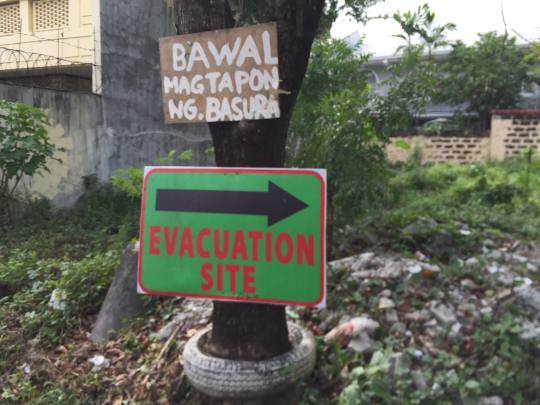
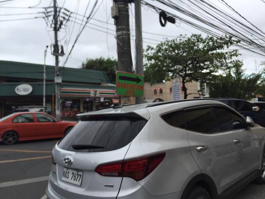
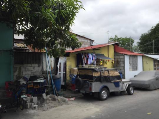
These are the best practice of our barangay:
Our barangay has posted tarpulin signs everywhere so that when disasters struck people would be knowledgable where are the evacuation sites/safe places.
0 notes
Photo
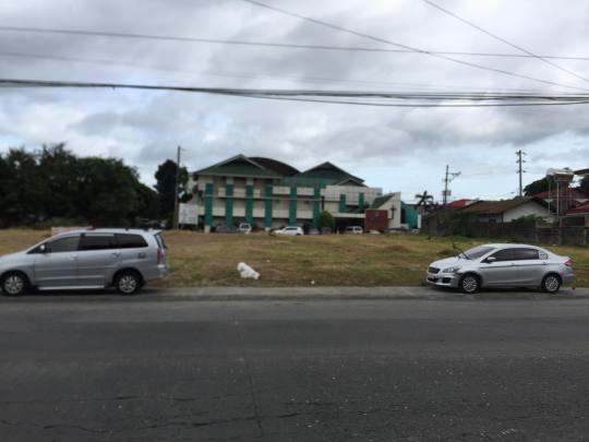
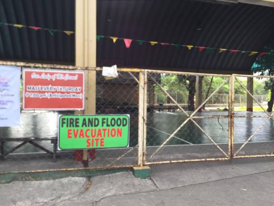

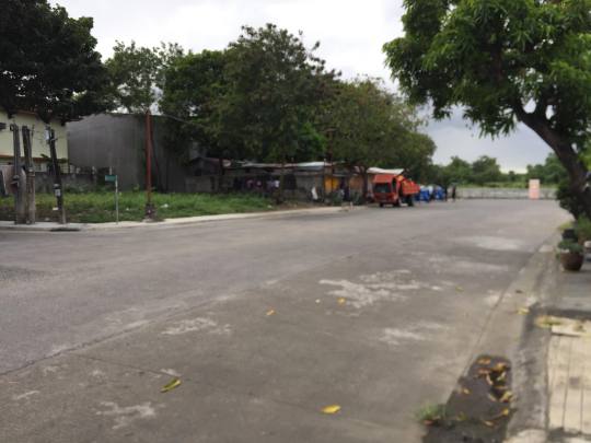
These are the safe places in Talon Dos:
The two are open spaces that can cater up to 50 families
The bottom left is the bamboo court which can cater 25 families.
(There are many more evacuation sties)
0 notes
Photo
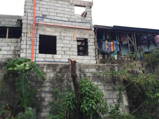
These are the hazardous places in Talon Dos:
On the topmost is the Satima Compound where risk of fire is high
On the bottom left is the lowest ground in our village which usually floods even with weak rains
On the bottom right is the manggahan where wood houses of informal settlers are prominent. Has a high risk of fire
0 notes
Photo
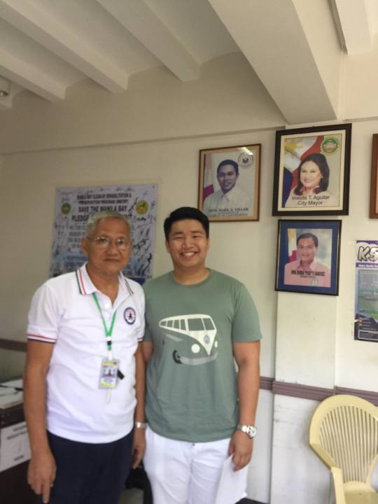
This is Sir Cris De La Cruz who is in charge of Risk Reduction in Talon Dos
0 notes
Text
DRRM Kuwentuhan
Disasters has been in our world since the dawn of man and one characteristic of disasters is that it can not be predicated easily, that is why today we promote disaster risk reduction management to avoid casualties and people getting hurt. Sometimes disasters are caused because of the hazards in our environment. So, being aware of hazards nearby could lessen the casualties and destruction so we must know what are hazards.
After the interview with our barangay tanod in Talon Dos, Las Pinas City I learned what are the hazardous places that can cause destruction. In places that has a lot of informal settlers that lives in homes that are made out of wood, messy wiring and a lot of fire hazards is one of the prominent hazardous places with high risk of disaster so we must be aware of that. Places also with a low ground level can cause high floods. We must look into our places before staying there to know what are the risk that we might face when disaster comes. In our barangay the most vulnerable people are the one who are dependent mostly kids and senior citizens because they are the ones who needs guidance, who needs help from adults, and relatively weaker. We must take into consideration with these people and know what is the most convenient for them when disaster strikes. In Talon Dos I am confident to say that we have enough evacuation sites to cater the people who are mostly in hazardous places because we have a lot of open spaces and basketball courts that can be turned into evacuation sites. Numerous of the hazardous places in Talon Dos are the informal settlers’ residences and the low lying places. Like manggahan and satima compound which has a lot of houses made out of wood and are really closed with each other that can make fire spread easily. Vatican drive is also a hazardous place because it is the most bottom place in our village, when it rains all the water goes down their and usually floods even with weak rains.
One thing why the community experiences this is because of people being ignorant of hazardous places. They say that “hindi naman mangyayari yan” line but it is not true anything can happen and people must be aware of his/her surroundings. We must know what hazards are in their environment so that they can take action to lessen casualties when disaster strikes. To solve this kind of problems the government must always advertise about disasters. The citizens must see the value of looking around and knowing what are the hazards are. They must also host seminars that could teach people basic first aid so that when medic is not around they can be the first ones to treat the patient. Today social media is a very big trend and it is a good thing that news about typhoons can be spread out easily with the use of social media so the government should also post about disasters and hazards to spread awareness.
Disasters are common here in the Philippines because we are located int he ring of fire. Typhoons, earthquakes, volcanic eruption, storm surge and many more. Disaster is not new word anymore among Filipinos but still we can’t avoid the deaths of people. One problem of people here in our country is ignorance and they precious more on their things than their lives. Like the volcanic reuption in Mayon, when the government announces to evacuate because of the incoming eruption some families prefer to stay because they don’t want to leave their houses because they precious their houses more than their lives. We Filipinos must not be ignorant of the disasters and hazards and must be aware so we can lessen the destruction and loss of lives. It is a good thing our government has a department for disaster risk reduction which is DRRM which has also the budget for rescues and food donations when it is needed. Another thing is PAG-ASA can announce typhoon before it hits in our country where they also indicate how severe can a typhoon can be, which is a good thing so that our people can prepare and be ready.
After the interview I had with the barangay tanod and the community talk I have become more aware of my village’s surroundings and I have more knowledge on what to do when disaster strikes so I can protect my own family. I learned that being a barangay tanod is also hard because of the plans you need to make for disaster risk reduction and it is not easy to handle many families and people with a small unit of government which the barangay. We must help also our barangay and support because it is our own good as well.
We need to address this kind of problems because this is a big thing. As we know we will have the “big one” which is a very strong earthquake so we must take action. We must teach and raise awareness to the people about disasters because Im sure not all understands hazards and disasters. There is a lot of Filipinos following the wrong practices when there are disasters so we must change that so we can avoid massive loss of lives. We can address it by implementing disaster risk management to schools so that not only adults would know what to do but also the students so that all of us know what to do when these things happen.
As a Thomasian student one thing I can do to lessen the vulnerabilities is to simply teach them the basic first aid, the difference between disasters and hazards, the causes and effects of these disasters, effects on our bodies etc. because after what I learned from DRRM I got an idea how disasters can be a really bad thing so teaching a brief knowledge about this would help people who are vulnerable. I can start with my family and then with my friends and this will get passed on and hopefully this will spread out to the whole community.
0 notes