
Urbanism, Architecture and Planning. We design, make and explore.
Don't wanna be here? Send us removal request.
Statistics
We looked inside some of the posts by grayspacee and here's what we found interesting.
Average Info
Notes Per Post
4
Likes Per Post
4
Reblog Per Post
0
Reply Per Post
0
Time Between Posts
28 days
Number of Posts By Type
Text
15
Photo
2
Last Seen Tumblr Blogs


Fun Fact
The total number of visits Tumblr.com received during January 2021 is 327 million.
Text
Missing Middle
What will your client base look like over the next decade? Where is the gap in the market to develop a scale-able property product? The table below shows the two biggest markets predicted for the next decade will be first home buyers and down sizers. If the trend continues, more millennials will enter the work force, and immigration - where the average age of a new migrant is 29 years will continue to drive demand for new housing. Furthermore, with baby boomers leaving the work force, the demand to downsize will create new housing stock.

We currently have is a problem with the ‘missing middle’. A product designed to service the customer. These multi-unit housing types typically consisted of duplexes, fourplexes, bungalow courts and mansion apartments that are not bigger than a large house. These housing types were integrated in most pre-1940s neighborhoods and often adjoining blocks with single-family homes. They provided housing diversity and generated enough density to support local commercial centers. This diversity was once a common feature in pre-war building stocks, but these housing types have become less common.

The missing middle typically yields between 30 to 55 dwellings per hectare. Failing to achieve these densities in effect creates neighborhoods which are not self sustaining. What we have seen is a widening gap in-between achieving 30 dwellings and over 55 dwellings per hectare. In order to increase densities on greenfield sites in the growth corridors volume home builders are getting down to as low as 225 sq m lots. On the other side, developers are looking to create densities above 55 per hectare in order to make apartment yields stack up for the commensurate risk. All of this creates a missing middle where densities between 30 and 55 dwellings are un-attainable.
The problem of the ‘missing middle’ can go in several directions. There are a couple of key trends occurring in the construction industry.
1. The lack of apprentices, sub-contractors and trades is a ticking time bomb for the industry
2. There have been a number of overseas acquisition of Australian residential construction market. The market is ripe for these new players to disrupt the industry’s inefficiency and create new housing distribution models.
3. Large developers looking to leverage financial markets to shift their business models from traditional residential making to new smarter alternatives
The supply of housing is set for a shake up, but where will it go?
Demographics table by Matusik Property Insights are Housing Market Consultants.
Missing middle by David Chandler, Western Sydney University https://www.thefifthestate.com.au/columns/spinifex/why-have-we-failed-to-implement-a-viable-missing-middle-strategy
2 notes
·
View notes
Text
A Re-defination of the Garden Area – Amendment VC143
The government’s new VC143 amendment aims to clearly define the term ‘garden area’ in the planning scheme. Amendment VC110 announced in March 2017 provided us with an ambiguous definition of terms with no practice note explaining how it should implemented. Two VCAT cases gave us a clearer idea of where the tribunal position stood.
In the matter of Guler v Brimbank CC VCAT answered the question regarding the use of eaves. The applicant raised the question that to comply with the garden area requirement the design would need to be uneaved. Council noted this did not reflect the detailed design of the area. The presiding member agreed and a strict definition of garden area needed to be adhered to and eaves could not be included.
The consideration in Sargentson v Campaspe SC determined the use of garden areas where the is subdivision of a lot. Council’s view was that the garden area calculation of 30 per cent should be applied to the resultant lots of 506sqm and 530 sqm applying the wording as it relates to subdivision. The tribunal disagreed as the combined development and subdivision application was not creating lots of vacant land.
Amendment VC143 doesn’t change the need for a garden area calculation. Rather it re-defines how it will be calculated. The new definition reads:
Any area on a lot with a minimum dimension of 1 metre that does not include:
a) a dwelling or residential building, except for:
an eave, fascia or gutter that does not exceed a total width of 600mm;
a pergola;
unroofed terraces, patios, decks, steps or landings less than 800mm in height;
a basement that does not project above ground level;
any outbuilding that does not exceed a gross floor area of 10 square metres; and
domestic services normal to a dwelling or residential building;
b) a driveway; or
c) an area set aside for car parking.

The new definition allows areas under eaves and outbuildings to be included within the garden area calculation. Furthermore where a basement does not project above 'ground level,' the area can be used within the garden area calculation. There has also been a change to landscaping elements. Raised deck, patio, and stepped area that do not exceed 0.8m above natural ground level are also included in the garden area calculation. We have already seen a change in council’s position on a number of projects Grayspace has been involved with. Our initial estimates have shown, we are able to get a 5% extra floor yield.
There are some developments that are exempt from the garden area calculation:
Sites with approved development plans, incorporated plans, precinct structure plans or other equivalent strategic plan are exempt
Sites where the existing buildings do not comply with the minimum garden area prior to the introduction of VC110 have also been exempt.
Sites with single dwellings on a lot that do not require a planning permit
Whilst we welcome any further clarification; Guler v Brimbank CC has taught us that there are still some un-answered questions. The definition remains silent on over hanging / cantilevering elements of the building design. Nor does it address sites with swimming pools or tennis courts.
The biggest change will be felt on single dwellings on a lot. The exemption from the garden area requirement will remove any controls that restrict the size of the dwelling. This applies to both inner city dwellings where lot sizes are less than 500sqm and outer suburbs where single lot developments do not require a planning permit.
0 notes
Text
Where is Density in Melbourne Increasing the most?
We have recently been looking at population and housing statistics looking at projected growth in relation to housing demand and supply factors. The chart below shows net annual population growth and how it is spread across Melbourne.

The chart below highlights a doubling of dwelling approvals across Melbourne since 2007. As can be seen there has been a surge in dwelling approval rates in inner Melbourne which almost matches dwelling approvals in the growth corridors of Melbourne.

Whilst Melbourne doesn’t have formal population targets for different regions, there are policies which aim to address this. For example, Melbourne 2030 stated
reduce the overall proportion of new dwellings in greenfield sites from the current figure of 38 per cent to 22 per cent by 2030
When looking at dwelling approvals figures within growth area LGAs. This seems to reverberate some of the policy positions.

The 2014 Victoria in Future projections have around 45% of dwelling growth occurring in the outer growth areas between 2011 and 2031. The Plan Melbourne share of dwelling growth in the outer growth areas to the year 2051 is 39%.
Take away
· Dwelling approvals in “inner” Melbourne almost match the outer growth areas in number; however this is not translating to a surge in population growth in established areas; Are we building the wrong product at the wrong price point?
· There has been a significant shift in the location of growth from the inner and middle ring suburbs to the outer regions; Is it easier to develop in the growth corridors?
· Its no surprise that policy factors and supply outcomes have changed after a significant shock to the economy
· All planning strategies and policies have contingencies in place to become less reliant on growth in the outer suburbs
All statistics charts by Chris Loader from Charting Transport
0 notes
Text
Monash Planning Scheme - C125 an update
A year ago the City of Monash introduced amendment C125 which impacted all land currently zoned General Residential and Neighbourhood Residential to reflect the objectives, directions and actions of the Monash Housing Strategy 2014. The amendment proposed changes to the existing schedules and introduced new schedules to GRZ and NRZ zones.
After substantial planning discussions, process and panel hearings the amendment was lodged with the Minister for planning for approval. The Minister recently informed the Mayor that part of the amendment would be approved with the remainder of the amendment shifted to a separate amendment which is still under review.
The approved section of the amendment will have implications for properties zoned Residential Growth Zone and Neighbourhood Residential Zone within the LPPF. However, the distribution and location of the proposed General Residential Zones has been shifted to the ‘under review’ part of the Amendment.
· Changes to all the schedules within the Neighborhood Residential Zones
· Changes to some of the schedules within the Residential Growth Zones
· Changes to the Local Planning Policy Framework to include references to the Monash housing strategy
In my Opinion:
The changes generally are designed to reduce development and to encourage greater residential development around Monash National Employment Cluster and the Clayton Activity Center. Proposed new development will need to take greater consideration of landscaping and protecting the garden suburban character.
As with all amendments some sites gain whilst some sites loose. The proposed changes will have greatest impact on sites on main roads. Development yields will increase on some site. All new applications will require greater scrutiny and consideration for landscape character.
The proposed changes will impact on a high portion of developable land in Monash. If assistance is required, contact one of the Grayspace team.
0 notes
Text
PARKING: THE PROBLEM WITH MAXIMUM RETURN ON LAND USE
The need for amenity vs the need for car parking is increasingly becoming an area of conflict that is becoming harder to ignore. Cities are increasingly grappling with how to reduce and discourage use of single occupancy vehicle modes of transport. Melbourne’s first strategic plan in 1929 outlined the increased problem with car ownership:‘… increasing desire on the part of the owners to use the curb space … who have come to regard this facility as a moral obligation on the part of the authorities to preserve for them.’
The problem with parking is that it is seen as a minimum requirement. With population growth, space is a premium. It’s difficult to determine the true value of parking. Research by What the Street found that approx. 14% of LA County is taken up in car parking. Future predictions are developments with an inactive car spaces will become a thing of the past. To get an understanding of why, can be seen in the economics of paid parking. Paid parking aims to achieve a fair contribution for the utilization of land while finding a balance between access for short-term visitors whilst discouraging increased congestion. Research suggests that where there is 100% occupancy, it takes approx. 3.3minutes of cruzing to find a car space. The ideal rate is 85% ie: for every 20 on street spaces 3 should be vacant. This will result in minimal cruzing time. The challenge for cities is to provide consumers multi-mode options where consumers need to determine what value they place on their convenience. Some cities around the world have started creating real time on demand parking where rates can be adjusted based on demand for parking. In this model consumers need to compare convenience against transport choices such as public transport, walking or cycling. Developments around he world are changing to accommodate multi-modal transport options. Occupants and developments will have to change how they address these issues. As we enter a world of driverless cars all developments will need to play their part in how we address congestion.
The City of Melbourne has fired the first shot in this conversation. Amendment 308 has proposed how car parking is going to be designed in the central city. All new car parking developments must either be under ground or located at level 1 or above with a floor-to-floor height of 3.5m minimum. Car parking is being pushed away from the actively parts of our city with the potential for re-use. The City of Melbourne is prioritizing walkability ahead of cars. These proposed controls will enable future re-adaptation as driverless cars, shared modes of transport become more common use. The City of Melbourne has also proposed one CBD grid to be car free and pedestrianized. In the sort terms there will be a premium of development with car spaces.
Professor Donald Shoup from UCLA makes a very good point ‘if we want to encourage housing and reduce traffic, why tax housing to subsidise cars?’
1 note
·
View note
Photo


Australian Islamic Centre by Glen Murcutt & Elevli Plus
The project was totally funded by the local islamic community and constructed from in situ concrete expressing a welcoming openness to all. The building successfully established a new architectural language for Islamic institutional architecture in a contemporary Australian context. It has gone on to be nominated amongst the top buildings that shaped culture through out the
The design uses 96 gold-painted lanterns to funnel light into the prayer spaces below, creating a multicoloured pattern of yellow, red, green and blue oculi each coming alive as the sun move.
The project has taken almost a decade of work for the Australian Islamic Centre to come to fruition, with the end result being worth the wait.
0 notes
Text
Casey Amendment C219: Changes to Cranbourne West
Casey Planning Scheme Amendment C219 (the Amendment) seeks to re-zone approximately 133 hectares of land under the Cranbourne West Precinct Structure Plan. The Cranbourne West Precinct Structure Plan (CWPSP), identifies the PSP land for a mix of industrial and residential uses, with the majority of land being for industrial. The proposed amendment proposes to change the current mix to residential uses. The planning panel report is currently with the planning authority who will review and address any short comings.
The Council propsoed to remove the land north of Central Parkway/Wedge Road and place the Amendment on public exhibition. Council submitted that the Amendment land is unlikely to be developed for employment purposes other than for small-scale development similar to that evident in the northern part of the precinct. A number of state agencies opposed the rezoning on the basis that the changes were not strategically justified and were inconsistent with regional and metropolitan strategies. Submissions from local residents were split equally in favour and against the Amendment. Those supporting the Amendment expressed concern about the amenity impacts of heavy vehicles and pollution from industry. Those in support expressed the need for local jobs and the inconsistency with the planning for the area.
The Panel concluded:
· There is sufficient medium to long-term industrial land supply in the Southern region if the Amendment is approved.
· The approval of the Amendment would have only a minor impact on the supply of industrial land in the Southern region.
· The constraints on the land, particularly its proximity to residential land, will make it difficult to attract some industrial uses.
· The constraints on the land do not make it unsuitable for all forms of employment use.
· The Amendment land is suitable for residential development.

0 notes
Text
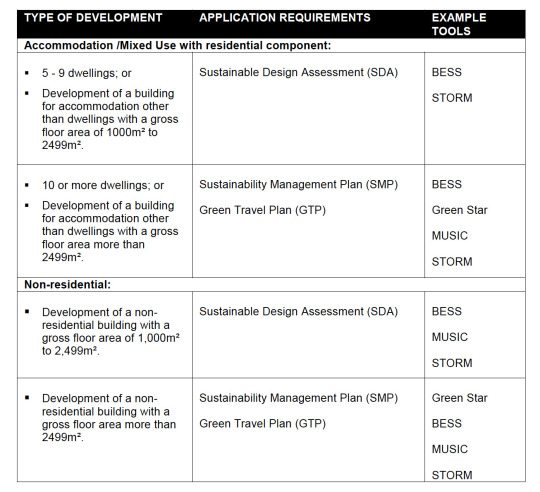
CITY OF GREATER DANDENONG CLAUSE 22.06 ENVIONMENTALLY SUSTAINABLE DEVELOPMENT.
Amendment C201, Environmentally Sustainable Development currently under exhibition seeks to introduce Clause 22.06 Environmentally Sustainable Development (ESD) into the Local Planning Policy to the Greater Dandenong Planning Scheme.
The purpose is to ensure that development achieves best practice in environmental sustainability from the design stage through to construction. The policy aim is to improve sustainable design outcomes and minimise costs associated with poor design including long term operational costs for new residential and non residential buildings.
The ESD Policy proposes to introduce objectives in relation to Energy performance, Water resources, Indoor environment quality, Stormwater Management, Transport, Waste management and Urban Ecology. Planning permit applications will need to include a Sustainable Design Assessment or a Sustainability Management Plan, as determined by the size of a development.
0 notes
Text
Changing Employment trends Census 2016
The 2016 Census data has revealed a number of changing key trends how we work and how we live within the capital cities. Census Place of Work data reveals the following:
· Over 900,000 new jobs were created in metro Sydney, Melbourne, Brisbane, Perth and Adelaide between 2011 and 2016.
· Majority were in the Health care & social assistance industry (153,900), Education & training employment (104,200),
· While the major capital cities thrived, the rest of Australia saw a moderate increase of 5,400 jobs.
· Melbourne experienced strong growth in employment, largely in Health care & social assistance (23 per cent) and Education & training (15 per cent). In addition Accommodation & food services and Professional services was also a large contributor to Melbourne’s employment.
· In Adelaide almost 50 per cent of employment growth was in Health care & social assistance. Adelaide’s economy has shifted from manufacturing industries to population serving industries.

Source: ABS Census of Population and Housing (2006, 2011 & 2016)
WHAT CAN WE TAKE AWAY?
Businesses are choosing to locate in high productive inner city areas resulting in increased growth in metro areas of the capital cities. Employment in both Sydney and Melbourne has become more concentrated in the inner city over the last 10 years. The concentration of jobs is creating economic benefits to businesses as they have greater access to higher skilled employees. As more people choose to live close to high quality employment, pressure on housing and transport will only increase. The new economy is also showing sign of change reflecting an ageing population and the lifestyle choices offered.
The new buzz word is ‘Employment and innovation Clusters.’ The VPA has identified seven clusters, which aim to center business activity around medical, research and tertiary institutions. Interlocked with these clusters will be transport options and housing options.
0 notes
Text
CITY OF WHITEHORSE AMENDMENT C191: INTERIM SLO
Amendment C191 gazetted on 8 February 2018 on an interim basis applies a Significant Landscape Overlay (SLO) to all residential zoned land currently not in an SLO
The Whitehorse Neighbourhood Character Study states that “vegetation character is generally the most significant determinant of neighbourhood character” in the city, whilst the Housing Strategy (2014) aims to manage the significant population growth and change that is anticipated over the next 20 years. The community engagement undertaken by the council showed that residents across all age groups highly value trees and the leafiness across the municipality and that maintaining and protecting these character values is a key priority for Council.
Council identified ‘moonscaping’ of properties where all the trees and vegetation on a site are removed prior to development is occurring. Council regards the tree canopy loss as a legacy issue that is irreversible.
· The interim SLO controls are in place while permanent SLO controls are concurrently being developed by Council.
· A Permit will be required to remove, destroy or lop a tree which is greater than 5 metres in height and/or has a single trunk circumference of 1.0m or greater at a height of 1 metre above ground level.
· A Permit is not required to remove a tree in the Residential Growth Zone if the tree is outside the minimum street setback.
· The interim controls will expire on 31 December 2018.
· There are no transitional provisions applicable to the SLO and therefore will take effect immediately.

0 notes
Text
How will the City of Monash change?
The Independent Panel provided a report assessing the viability of the amendment. Some of the panel’s recommendations were:
· That the Amendment abandon the rezoning of land in the ‘Monash National Employment Cluster’ and maintain the current General Residential Zone (Schedule 2) for the land.
· Land currently in the GRZ2 remain in this zone (as a holding zone pending future investigations) if it is identified in the Housing Strategy as having future redevelopment potential
· General Residential Zone (Schedule 3) and General Residential Zone (Schedule 4) should be combined with the requirements in the schedule to be watered down and less restrictive.
· Local policy to be amended to recognize distinctive areas and provide an appropriate response (eg: areas on main roads and residential hinterland sites have differences in character).
· The impact of residential development should be managed through a ‘Development envelope’ rather than ‘number of dwellings’ on a block,
· The Panel recommended that land identified as having ‘future redevelopment potential’ should be retained under the current General Residential Zone (Schedule 2).
· The panel recommended that local policies be revised, including the ‘Preferred Future Character’ statements, to recognise that change is supported in areas identified as having future development potential including in the ‘accessible areas’ and on main roads.
· Apartments, multi-level town houses, ‘side-by-side’ and ‘front back’ forms of dual occupancy can be an efficient means of achieving high amenity housing. These types of developments are an important form of housing to support housing diversity and affordability, and should be part of the Housing Strategy and neighborhood character policy.
In my Opinion:
The changes generally are designed to reduce development within GRZ and NRZ zones and to encourage greater residential development around Monash National Employment Cluster and the Clayton Activity Centre.
The proposed amendment fails to address and adequately differentiate between land specifically identified as having potential for higher density housing and the more remote hinterland areas. The amendment fails to distinguish areas that do not share the same contextual and strategic advantages. In short, the proposed schedules are excessive and are a restrictive blanket approach.
The amendment looks to limit ‘Density’ as it closely aligns it to character ‘garden city’, landscape, heritage and amenity aspirations. Limiting ‘density’ results in fewer housing typologies, which reduces affordability and housing diversity. Opportunities for people who want to stay and downsize or first home buyers are greatly limited.
Given many of the Panel’s recommendations have not been followed there must be some doubt as to what weight should be given to Council’s final adopted version of the Amendment.
0 notes
Text
Monash Planning Scheme - Amendment C125
The Amendment applies to all land within the City of Monash currently zoned General Residential and the Neighbourhood Residential and reflects the objectives, directions and actions of the Monash Housing Strategy 2014. The amendment changes existing schedules and introduces new schedules to GRZ and NRZ zones. It also makes changes to land in the Monash National Employment Cluster and the Clayton Activity Centre. Specific changes include:
· A minimum allotment size of 300m2 for some Neighborhood Residential Zones Schedules
· The introduction of Schedules 3, 4, 5 and 6 to the General Residential Zone.
· General Residential Zone Schedule 3 and 4 generally to the areas identified as the Garden City Suburbs.
· Introduction of a Design and Development Overlay to provide direction on preferred building heights within the Clayton Activity Centre and the Monash National Employment Cluster.
These changes reflect the Monash Housing Strategy 2014 which was adopted by council in October 2014. The Strategy includes a Residential Framework Plan, which sets out aspirations for the form and intensity of development in different locations. The aim of the housing strategy is to provide clearer directions about appropriate location for increased residential development which reflect the aspirations for the community regarding the residential garden city character. In addition, the housing strategy also tried to better reflect the changing population needs and to provide direction on how to best met them.
On 22/06/2017, the amendment was submitted to the Department for Approval. The outcome is still unknown. We recommend that, if you have land in the City of Monash, you get expert advice on your development.
0 notes
Text
Is Planning the next Disruption?
First it was drones bricklaying, then there were driverless cars now we are talking about automated infrastructure, where is this all going? The future is very clear, the connected city; big data is influencing decision making about how we plan, organize and design our cities.
The company that owns Google recently decided to go from making software to developing cities. Sidewalk Labs, sister company to Google, is in the early stages of developing a 12-acre strip in the center of Toronto, which will become the first high tech district, which will be fully connected. Sidewalk Labs want to re-think the city ‘from the internet up.[1]’ What exactly that means for us I’m not sure, but Sidewalk Labs have been experimenting within New York. The first test project five years ago was to create a network of wi-fi kiosks. Since then they have partnered with the Department of Transport in the US to create a traffic data platform. The move towards collecting, monitoring, aggregating data to inform city planning is well underway.
‘Dan Doctoroff head of Sidewalk Labs has spoken often about how technology like autonomous transit, high-speed internet, embedded sensors and ride-sharing services could transform urban life. He's also hinted at technologies ability to overhaul zoning rules and control housing costs, a particular interest of Larry Page one of the founders of Google[2]’. One school of thought is that by relying on big data, better modeling for the city can lead to more effective policies and targeted solutions.
Details on how a private enterprise could finance a profitable business model and all question of how to recoup investment seems to be closely guarded. Sidewalk Lab’s partner organizations in Toronto Quayside, has hinted profitability will come through value capture mechanisms which rely heavily on future real estate gains. Questions about bridging the political divide and common law principles such as natural justice and nuisance have been left unanswered. At this early stage there are more questions than answers.
In the immediate term Toronto will get a new 2,000-acre waterfront community that is intended to ‘serve as a test bed for emerging technologies, materials, approaches and processes that will address these challenges and create a new global benchmark for sustainable, inclusive and accessible urban development.[3]’ Not ambitious, innovative or revolutionary at all.
[1] Smart Cities NYC conference 2017, Sidewalk Labs Chief Executive Officer Dan Doctoroff
[2] May 9, 2017, 7:37 AM GMT+10, Alphabet's Sidewalk Labs Eyes Toronto for Its Digital City, Mark Bergen, 5/21/2017 Alphabet's Sidewalk Labs Eyes Toronto for Its Digital City Bloomberg.https://www.bloomberg.com/news/articles/20170508/
[3] Sidewalk Labs May Build a High-Tech City District From Scratch in Toronto BY KELSEY E. THOMAS | MAY 9, 2017
https://medium.com/sidewalk-talk/a-key-to-democratizing-urban-solutions-is-building-better-models-7ecc9eea7908
0 notes
Photo

Australia's estimated resident population (ERP) reached 24.1 million at 30 June 2016, increasing by 337,800 people or 1.4% since 30 June 2015.
Victoria had the greatest growth (123,100 people) increasing by 2.1%, followed by New South Wales and Queensland (both 1.4%).
Melbourne had the largest and fastest growth of all Greater Capital Cities (107,800), followed by Sydney (82,800), Brisbane (41,100) and Perth (27,400).
The three Statistical Areas Level 2 (SA2s) with the largest population growth in Australia in 2015-16 were outer suburbs of Greater Melbourne: South Morang in the city's north, Cranbourne East in the south-east (both 5,000), and Craigieburn - Mickleham (4,500) in the north.
Source ABS
1 note
·
View note
Text
Amendment VC136: New apartment design guidelines

The State Government over the Easter weekend has formally gazetted the Better Apartment Design Standards or BADS into planning schemes. The BADS provide a new set of guidelines for the design and amenity of apartment development across Victoria. The changes include:
· Introduction of Clause 58: a series design objectives and standards to assess the internal amenity and design and how it responds to the site.
· Amendments to Clause 55: including a new set of design assessments.
· Amendment of Mixed Use, Township, Residential Growth and General Residential Zone to include the trigger for Clause 58 assessment.
Amendment VC136 broadly separates apartment development into two separate categories: less than or greater than 5 stories in a residential zone.
· Apartments up to 4 storeys in a residential zone will be assessed against Clause 55 plus some specific clauses of Clause 58
· Apartments of 5 or more stories in a commercial zone will be assessed against the full 27 standards and objectives of Clause 58.
Some of the key changes include
Building setbacks
Setbacks for design will now be measured by qualitative standards relating to character, daylight, privacy and outlook.
Private open space
Private open space for some bedrooms and apartments has increased depending on the apartment size and location.
Windows
Habitable rooms are now required to have a window in an external wall. New restrictions are now in place for ‘saddle-bag’ bedrooms and internal light wells and borrowed light not longer acceptable.
Natural ventilation
At least 40% of apartments of within the development need to have cross ventilation.
Landscaping
The new provisions include a requirement for deep soil and canopy trees.
Communal open space
Developments with more than 40 dwellings are required to provide landscaped communal open space with direct sunlight.
Internal layout and accessibility
There are now minimum dimensions for bedrooms and living rooms. In addition, 50% of apartments to be universally accessible; thus wider internal passageways and larger bathrooms.
Room depth
Single aspect’ rooms may not have a depth of more than 2.5 times their ceiling height. EG: where the ceiling height of is 2.4 m, the maximum depth of the living room will be 6.0 m.
Storage
New provisions for storage within the dwelling in kitchens, bathrooms and bedrooms are to be provided.
So, whilst the internal amenity requirements of apartments will increase, the introduction of the BADS will have some unintended consequences:
· There will be fewer opportunities to develop apartments on narrow-to-moderate width lots in residential zones
· Increased floor-to-floor dimensions will result in fewer floor numbers
· Less efficient buildings due to longer corridors
· Smaller dining and kitchen areas potentially balancing up larger living, bed and bathrooms
· Hallways and passageways potentially relocated to the outside of buildings
· A reduction in basement areas due to the increased deep landscaping requirements.
In the long run the new changes will create a two tier apartment market with apartments pre BADS vs post BADS.
The state government has promised additional guidance on how to interpret the objectives and standards of BADS.
Grayspace will provide regular updates on important planning news impacting your development. Contact us if you require specialist planning advice on your project.
0 notes
Text
THE GARDEN AREA REQUIREMENTS – WHAT TO EXPECT
One of the key changes to the re-formed planning rules is the introduction of minimum garden areas. There are already a number of different measures that affect how much of a site can be covered by a building and what is left over for open space or garden areas:
· Site coverage – 60%
· Permeability – 20%
· Secluded private open space
These requirements are discretionary and can be varied if justifiable and meets the objectives of the policy
The new Garden Area requirement unlike the above measures are a mandatory requirement and cannot be varied in any circumstance. The ‘Garden Area’ as defined in Clause 72 of each Planning scheme states:
An uncovered outdoor area of dwelling or residential building normally associated with a garden.
It includes open entertaining area, decks, lawns, garden beds, swimming pools tennis courts and the like.
It does not include a driveway, any area set aside for car parking, any building or roofed area and any areas that has a dimension of less than 1 metre.
The minimum requirement to be set aside as Garden Area are as follows:
· 400 - 500sqm = 25% lot area
· 501 - 650sqm = 30% lot area
· Above 650sqm = 35% lot area
Cases Studies
Where the maximum proposed site coverage is 60% that leaves 40% to provide SPOS, POS and vehicular access. Under the new rules SPOS and POS would need to add up to 35% of the site. That leaves an impossible 5% to allow vehicular access.
CASE STUDY 1: No changes to rescode requirements
· Site Coverage 60%
· Permeability: 20% min
· SPOS – 40sqm (25sqm POS)
Site Area – 697sqm
Site Coverage – 335sqm
SPOS & POS - 150sqm
Driveway – 155sqm

The proposed design meets our obligations under the previous requirements with 48% site coverage and 25% permeability. It also allows us to provide minimum 25sqm POS on ground floor and the shortfall 15sqm on the first floor balcony. The proposed driveway makes up 23% of the site.
Under the new garden area requirements 35% of the site or 244sqm would need to be garden area. Without any doubt the result will reduce the yield due to the reduced ground floor footprint. The current design only allows for 22% garden area.
CASE STUDY 2: Changes to rescode in the schedule to the zone
· Site Coverage 60%
· Permeability: 20% min
· SPOS – 80sqm (60sqm POS)
Site Area – 1011sqm
Site Coverage – 377sqm
SPOS & POS - 385sqm
Driveway – 190sqm

The proposed design meets our obligations under the previous requirements with 37% site coverage and 34% permeability. It also allows us to provide minimum 80sqm POS on ground floor. The proposed driveway makes up 19% of the site.
Under the new garden area requirements 35% of the site or 354sqm would need to be garden area. The current design meets the new garden area requirements and achieves 38%.
Conclusions
We believe that new residential developments with larger areas of driveway or multiple driveways will be discouraged. We believe development with basement and ‘deep soil conditions’ to allow well landscaped areas will be encouraged. Alternatively with an increased height limit in GRZ, 3 storey development with smaller ground floor footprints will be encouraged. Reverse living options will not be encouraged as the primary SPOS will need to be located at ground level. Under croft parking and driveways (i.e. below overhanging first floors) will be encouraged, to better utilize long driveways. We believe this will become a contentious issue as a number of Neighbourhood character policies discourage cantilevering and first floor visual bulk.
The new Garden Area requirement being mandatory should be of some concern for certain typologies. It is common for multi-dwelling developments, especially apartments walk ups or reverse living, to have high site coverage. These building types will no longer be possible. The implications for built form will be less site coverage, less floor area and lower yields.
Over all the changes will impact on the urban form of our suburbs. The new garden area will inevitably increase the minimum permeability of most sites above the 20% suggested at Standard B9 of Clause 55. The new garden areas, which we assume will be permeable, will provide greater areas for on-site stormwater management, reducing the storm water run-off to our natural waterways and polluting the natural environment. We believe the consolidation of the built form will increase opportunities for landscaping and access to daylight. This we believe will increase the livability of many speculative developments.
0 notes
Text
Better Apartments are on their way
I was recently invited along with a number of other design professionals to a workshop organized by the state department looking at how the new Better Apartment Design Standards (BADS) will influence apartment development in Melbourne.
Firstly the new policy is set out in the same was as Rescode where there is an Objective, Standards and Decision Guidelines. Secondly the new guidelines will be included in Clause 55. These new guidelines will supersede any local planning policies such as the Moreland Apartment guidelines. The policy is broken up into three sub-categories:
· Building Envelope
· Building Performance
· Dwelling Amenity
My initial thoughts are the overall standard of apartment design will significantly improve when it comes to internal amenity and building performance. I also believe the number of sub-consultants will increase as developers look to find ways to vary the standard and try to meet the objective of the clause. I see an immediate proliferation of design consultants. Eg; the noise impact standard requires internal bedrooms to be assessed to have no greater than 35dB from any noise source from 10pm to 8am. Where the noise source can be an internal lift or an external park, compliance with the standard will require specialized knowledge.
On the negative side, I believe it will create a two tier apartment market where apartments pre BADS will loose capital value as apartments with higher standards come onto the market. The major unknown is if there will be an increase in apartment prices. The minimum apartment standards almost certainly mean floor areas and standard of finishes will increase. Thus it is inevitable, yields will reduce.
Whilst these new policy requirements are not officially released, a number of local authorities have started implementing the guidelines since the start of the year with VCAT already ruling in favor of some of the standards. Stay in touch with Grayspace as more in depth analysis will follow.
0 notes