
Don't wanna be here? Send us removal request.
Statistics
We looked inside some of the posts by jbillinghurst and here's what we found interesting.
Average Info
Notes Per Post
3
Likes Per Post
2
Reblog Per Post
0
Reply Per Post
1
Time Between Posts
2 months
Number of Posts By Type
Text
16
Photo
1
Last Seen Tumblr Blogs


Fun Fact
Tumblr Inc. is funded by 13 investors.
Text
Pureroa Forest Trip
Easter, so off to the Pureora forest vai Hamilton and Te Awamutu to visit Denise's sisters. First stop the Hamilton Gardens where an Egyption garden had been added since I was last there.

On then vai Lake Nga Roto and Te Awamutu to the DOC camp at Pureroa.

Nice big camp with only about 4 other campers who appeared to be doing the Timber trail bike ride, which I plan to do part of it one day. It was cold at night like 2 degrees cold, and I knew my gas bottle was getting low. Sure thing at 4.30 in the morning I awoke to a cold van so it was out into the 2 degrees to swap gas bottles. Lesson learnt. Next day I went for a bike ride to the forest lookout finding some old machinery on the way.

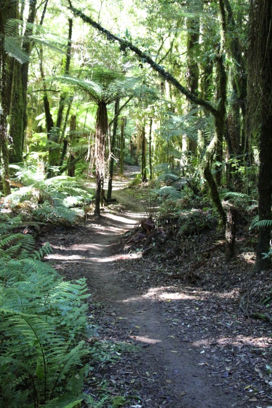
Then a short tramp through the Tototara bush track where one gets to acknowledge the massive trees that once covered the country. This forest was saved from milling by protestors in 1978 to enable us to enjoy the magnificent trees.

Many interesting things on this walk including a fern that looked like noodles.

The following day we walked a section of the bike trail. I was expecting a trail like I was used too, wide flat and graveled, but no this trail was narrow and twisting in and out of trees.
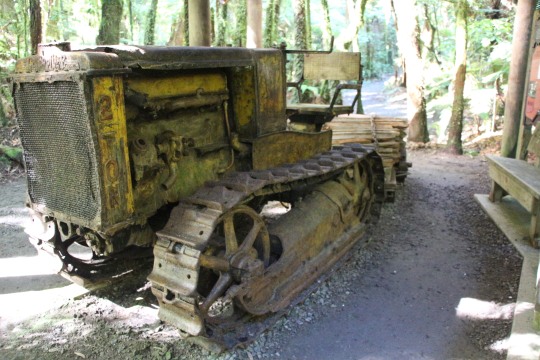
The trail passed an old crawler tractor that was used to gather fallen Totara logs and make them into posts and battens for the farming community. It had blown it's engine so was just left in the forest where it stopped to become an attraction on todays trail.
On the way back to camp passed the Easter Bunny having a nap after delivering all those easter eggs.

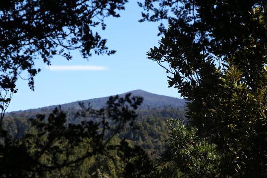
Next day headed to our next DOC camp at Kakaho. It was a forestry road and some of the pot holes would never see the sun, they were that deep. Passed the center of the North Island found by stringing a cut out map of the North Island to see where it balanced and this was the spot. At this DOC camp we tramped the Rimu walk through more impressive giant trees. This walk was a bit more challenging with many stairs.

But the view of Mount Pureora from the top was worth it.
There was only one other camper here so a very peaceful final night which included tea by the fire. Home the following day, a great trip to see some of those massive trees.

0 notes
Text
PORT JACKSON
Time for another trip. We left Tauranga in the rain( forecast was for clearing), to Hamilton where we picked up Denise's sister Heather. Onto the Coromandel with a fully loaded van, tent awning, generator, electric chilly bin, fish contiki, and enough supplies to last the five days. Stops on the way to admire the views and other reasons. Rain did not appear to be "clearing" as we hit the gravel for the last 30Km. The rain was running down the road faster than we were and quickly turning what gravel there was into mud. Climbing up over the last hill we viewed our destination, Port Jackson.

OK this photo was taken the day we left but if it had been fine this would have been the view. Miraculously the rain did clear slightly and we managed to set up camp.

The following day the rain had eased more so we set off to hike the Muriwai track that went from Port Jackson to Cape Colville then down the coast. Was a steep climb to get to the top of peninsular but the view out to Great Barrier and the cost was rewarding.

It was a very rocky coastline here and we spotted one brave fisherman trying his luck on the rocks below.

The track eventually joins the road which we chose to return to camp rather than retrace our steps crossing one of many fords on this road.

Back at camp the weather was definitely on the improve and we rewarded with a nice sunset.

Next day was an R and R day with a spot of fishing with the contiki which resulted in one, just legal snapper.The following day we planned a tramp in the other direction over to Fantail Bay but found the track was through private property with permission required. The fact that it was also very hot and the track went straight up through farmland with no shade made for a change of plans with a walk to the end of the bay where an old wharf stood.

Happy hour in the afternoons proved popular with us and the ducks.

The fishing was not going as I had been led to believe, with reports of great fishing posted on many websites. Undeterred I tried an evening fish with just one snapper again but the sunset was spectacular.

And so on the Friday after five wonderful days we packed up camp and headed home. Found an old Granite Quarry on the way out that we missed on the way in due to the rain. Stone from here was used for the Auckland Museum and Government buildings. Interesting. Thus ended our Port Jackson trip, apart from the inclement weather for the first day, most enjoyable.

0 notes

Text
Taranaki Tribulations part 2
Down from the Moki tunnel the road wound through the Tangarakau gorge next to the Whanganui river. This is the only part of the forgotten highway that is not sealed, although work was in progress to seal this part. It was on this “work in progress” area that disaster struck. I pulled over onto the shoulder to let an approaching car and trailer past but the firm looking shoulder turned out to be anything but firm. I suddenly found myself in axel deep mud on the left with my right wheels still on the new seal.

Fortunately there was a road inspection man checking on the new seal and came to my assistance. He drove back up to the works site trying to find a rope. He returned shortly with no rope but with a small furniture van that hopefully could pull me out of this situation. They didn’t have any rope but with plenty of straps that held their furniture in place. Joining these straps into a tow rope he attempted to tow me out. My van has a traction control button, essentially a diff lock function which I had never used. With this engaged and the furniture van pulling and with both my drive wheels spinning, albeit the right hand one digging a nice hole in the new seal, we were soon back on terra firmer. With nothing damaged except ones pride we continued on into Tamaranui. The rain returned with vengeance here and the decision was made to find a camp for the night. I chose the Ngaherenga DOC camp site in the Pureora forest park. It was a tad further than I thought and we arrived there in the dark. Trying to find a nice spot on a water logged grass area in the dark, with thoughts of a recent getting stuck episode on my mind, was a bit nerve racking. However the morning dawned fine and we found we were the only inhabitants in the park except for the prolific bird life, and as a bonus no hint of getting stuck. Not far from the DOC park we stopped at the impressive Pouakani Totara Tree. There was an article about this tree in one of my campervan magazines.

The tree is over a thousand years old and is the largest Totara tree in the world. Sounds American claiming largest in the world, as they do with almost everything, but this is one impressive tree. Was a nice forty minute walk through the bush but a nice break. Onwards and home bound now, cross the Whakamaru dam, lunch near Atiamuri, Rotorua and home. A good trip, a bit wet and one little oops but really enjoyable. Next trip is ...........
0 notes
Text
Taranaki Tribulations
Finally managed to drag Denise away from her farm for my much delayed trip to Taranaki. The weather was not pristine but hey, we would cope. Over the Kaimai's, through South Waikato and into the King Country with a stop at Te Kuiti to pay respects to Pine Tree.

On then into Taranaki and the freedom camp site at Tongaporutu where we intended to walk along the beach to the three sisters and elephant rock. These rocks can only be reached an hour either side of low tide which was when we arrived, buy rather than rush things; we were after all on holiday, we decided to wait for the following day. Heavy rain that night and we awoke earlier than expected thanks to an over enthusiastic groundman.

We wandered around the small village, mainly consisting of holiday homes, and learnt its history from an information board by the muddy rapidly rising river. Established in 1895, consisting of a ferry for crossing the river, it grew into quite a little settlement in the early nineteen hundreds. Low tide was due at 4pm, so just before then we set off down the river to visit the three sisters. This involved walking along the edge of the river where it passed a cliff to get to the beach. Knee deep at first rapidly increased to thigh and then waist deep as the river threatened to sweep us off our feet and out to sea. We retreated. All that rain had made the river higher than normal so the three sisters will have to wait a little longer for a visit from me. On then to New Plymouth with failing light and more rain. Made it to the NZMCA by the Huatoki Domain on dark. Well it was only 5pm but the overcast rainy conditions made it dark. I had an intermittent fault in the campervan where the seat belt light would come on followed by the airbag warning light and beeper. On this trip the intermittent nature was becoming more of a consistent nature and driving me up the wall. A search on Mr. Google revealed this to be a common fault on Fiats with some repairs costing in the thousands. With trepidation I phoned the local Fiat Motorhome dealer, AutoCity Prestige, who said bring it in and they would do a diagnostic on it to see what the fault was. I had recently had another warning light, hill start warning light, come on, and my local Tauranga dealer did a diagnostic on it, $25 please, and replaced a faulty brake light switch, another $400 thankyou. So with trembling wallet I drove into AutoCity Prestige. No appointment, they stopped what they were doing, plugged in their diagnostic computer which indicated faulty earth connection on seatbelt sensor, which they found to be due to a plug floating around under the seat which should have been secured. Duly secured, problem fixed. Cost. No charge sir, have a nice day. WOW! Think I'll drive to New Plymouth for my next service. Wonder if the floating plug had something to do with my Tauranga dealer.
Anyway with still more precipitation and indoor activity was voted for and that activity was the Puke Ariki Museum. What a fantastic museum, and all for free. The one thing that impressed me about New Plymouth was the councils attitude to visitors, their wonderful and many parks and their free access to parks, museums and the zoo. Well done New Plymouth. The Puke Ariki Museum was a treasure trove of the towns history. Spent an enjoyable few hours there. The information center is also at the museum so armed with brochures and with the promise of better weather tomorrow, we booked into Belt Road camp, walking distance to downtown, for the next two days. The weather forecast proved correct as the view from the bedroom confirmed.

We walked the Coastal Walkway back into town. Met some friendly locals.

Pukekura Park in the center of New Plymouth is another marvel of what a good council can do. Covering many hectares, there are waterfalls, lakes, bushwalks, flowers, bridges and even a zoo. To celebrate our arrival Mount Taranaki, (Mount Egmont to you old Caucasian's) showed itself above the lake. Crossing the lake is Poets Bridge. How romantic you say, a bridge called Poets Bridge. But no, a local board member bet on a horse in the 1883 Auckland sweepstake which duly won and the board member donated his winnings to build a bridge across the lake. The horses name; Poet. Today the reflection of Poets Bridge on the lake was inspiring.

Further through the park w and passed by e came across the zoo. Not expecting too much of a zoo, free at that, we entered. It was small but the range of animals and bird life was amazing. Well done New Plymouth. Casually wandering back down through the park we saw the Gables, an old hospital, the Chinese Garden and many other interesting features. Back in town we paused for some refreshments and passed by the Govett Brewster Contemporary Art Museum. One could not miss this building as the whole outside of the building was covered in reflecting glass. The main entrance was in a small wooden building next door. Must be a nightmare to motorist what with the sun reflecting and numerous other cars reflected from the glass.

Back at camp I decided to cycle the Coastal Walkway to its end about 10km away. Denise retreated with a book. Yet another council achievement this walk/cycleway winds along the coast passing surf beaches, driftwood beaches, camp grounds and marvelous views out to sea. I arrived at the Te Rewa Rewa bridge, so aligned that it frames Mt Egm....Mt Taranaki in its whale like frames. However the Mount was cloud hidden, but a few minutes later as I returned from Walkway end, there it was peeping out from the cloud.

Back to camp along the walkway passing the famed wind wand, I arrived right on happy hour, good timing. So with the sun setting over the Port what else could one do but extend the happy hour.

Next morning the rain had returned. We packed up camp,(put the empties in the recycling bin) and headed out of New Plymouth. The Pukeiti Rhododendron Botanical Gardens was the planned destination, but first a detour to Lake Mangamahoe, a lake a local had said not to miss as it provided a great photo of Mt Taranaki along the lake. Possibly but not today in the rain. This lake provides New Plymouth with it’s water supply so I was rather surprised to see this at the outlet.

Obviously the good people of New Plymouth don’t like eels in their drinking water. With the rain easing it was off to Pukeiti, the narrow road wound through native bush, then suddenly we were there The Pukeiti Rhododden.....etc etc.(What a word, here after called the flower place) We gathered up maps from the information center at the flower place and set off to discover, again all completely free. Those “flowers” were not at their best at this time of the year but it still was a very informative and enjoyable stroll. With the rain holding off we returned to the coast to have a look at the Cape Egmont Lighthouse on a barren piece of landing looking out to Australia somewhere in the distance. The rain returned with vengeance so a decision had to be made as to where now. I had planned the return trip home through the Forgotten Highway which start at Stratford and so with this biblical proportion rain it was decided to make for a camp ground in Stratford.
The following morning the rain had eased to the occasional severe thunderstorm so we set off on the Forgotten Highway. Taken slowly it is a very enjoyable trip with the road winding up and over a number of saddles offering spectacular views.

Passed through the republic of Whangamomona with its famous pub and up to the famed Moki Tunnel.

1 note
·
View note
Text
WAIARAPA WANDERINGS.
Enough of this COVID rubbish, time to travel again, so November the 18th I set off southward. First stop Taupo, and after viewing Huka falls it was around the lake for lunch. Always nice to stop besides the lake.

Across the desert road with the mountains hiding behind a vale of cloud, then onto the Gentle Annie road that runs from north of Taihape through to Napier. Fantastic rolling country through here with deep valleys and high peaks. Stopped at the Springvale suspension bridge built in 1925 to enable farmers to cross the Rangitikei River and take their produce to Napier. Was used up until 1970 when a replacement was built.

Thought of camping here for the night but a DOC camp further on sounded more enticing. And so it turned out to be with a large area beside the river with numerous camp sites tucked in the bush.

I had planned of going into Napier to visit ex brother-in-law Val Nicholson but numerous phone calls went unanswered so I headed down the coast by as many backroads as I could find. Narrow twisty roads led over hills only to descend into valleys where the inevitable woolshed was sited. Some of these woolsheds were run down and derelict but others were new and modern with huge covered yards. The only vehicles I passed were either a Ute with dogs on the back or a four-wheel drive towing a trailer full of sheep. Definitely sheep country. Passed through this little place with a big name.

Castlepoint and it's lighthouse seemed like a good place to stay, so I booked into a camp site mainly to use their ablutions. Walked along the beach from the camp and out to the Lighthouse. It is situated on a spit of land detached from the shore but easily accessible by a and bridge. Interesting rocks around the lighthouse, look very volcanic.

There was a moon eclipse that night, blood moon they call it, so I set up on the beach with my camera. More spectacular than the moon was the lighthouse which is bathed in a series of colours from white, blue through to red which reflected off the calm sea.

Next morning I took a walk on a track that led through pines and above the the beach along to Castle Rock. The isthmus that the lighthouse sits on leads to an opening out to sea creating a nice set for surfers and boat exit to sea.


Back down to the beach and a walk back to the camper passing some who wished they hadn't ventured out onto the beach.

Castlepoint done it was back inland to Masterton where I got a few supplies. Here also I found a large, like 43 hectares large, wetland with cycle trails through it. Having brought my bike all this way it was time to put it to use. Lots of bird life and good trails.

Finding a camp for the night before my assault on Cape Palliser my trusty app suggested Lake Wairarapa. Looked nice from afar but closer inspection showed a shallow muddy lake. Still it was a pleasant spot to camp for the night with only a coup[le of other campervans.
TO BE CONTINUED

And so down to the south of the North Island which is further south than Picton and Nelson. First stop the Pinnacles formed by rain washing away the ground under large rocks leaving these large rocks balanced precariously on top of, well pinnacles. And they are hundreds of meters high. The tramp up the valley took around an hour over a rock strewn water way. Glad I had my tramping boots.

Parts of Lord of the Rings were filmed here and it certainly had that middle earth feeling.

You get an idea of the size by the people in the bottom of the picture.

One hopes when walking under them that there is enough solid ground left to stop that rock on top falling down on you. Onto Cape Palliser its self and the lighthouse. The road is mainly sealed except for the last little bit where it goes around a headland and there is no road so to speak but a track cut into the rock, twisting and turning. A sign indicating unsuitable for long vehicles was no deterrent. The lighthouse itself is perched on a rocky outcrop up high, like 262 steps high and they are straight up.

By now it was raining but having come this far those steps had to be climbed. What a workout, I was completely shattered on reaching the top.

Comments on the app suggested that one could often see seals along this coast so at a likely spot I pulled over and explored. I saw two bull seals settling an argument and having won that battle the big fellow decided to check me out.


I retreated to my van and it was then that I realized that I had nearly parked on top of a mother seal feeding her pup. I had not seen them when I parked being more taken by the big bull seals.


The settlement of Ngawi along this coast is world famous in New Zealand for its collection of tractors for launching boats into the sea.

There were some pretty impressive machines and some that had seen better days and were just left to die in peace where they had finally come to a stop.


The weather was turning to...... getting worse so I thought I would head back to my tranquil campsite on Lake Wairarapa. This time I traveled around the western side of the lake hoping for a better view of the lake but the weather put paid to that.

My tranquil campsite was anything but tranquil that night as the wind picked up and at one stage I thought the wind may pick my van up. I shifted to a more sheltered spot by a hedge. Checking out the met service website it informed me that there was a gale warning for this area expecting 100 k not winds. Yep right on.

By morning the rain had eased so I pointed the van north. Stopped at Featherston as there was a museum I had read about that sounded interesting. It contained some of the Fell engines, these were the engines that pulled the train over the Rimutaka hill before the tunnel was built. Unfortunately said museum was closed so I carried on. Next stop Mount Bruce National Wildlife Centre or as its called now Pukaha etc. etc. Into the gloom of the kiwi house where two little kiwis were strutting around doing their thing. One of them was named Tia, a full blooded kiwi, not like the one I know who is part Aussy. There was also a Tuatara near by.

There were a number of aviary's spread through the bush walk, one of which you could walk in to. Peaking into these aviary's one could sometimes get lucky and see one of the inhabitants. I caught up with a group having a guided tour and was lucky to see the eel feeding frenzy.

One aviary had a Kokako in it that flitted back and forward at the front of the cage. Trying to get a photo proved rather trying as he didn’t stay still. I got a few out of focus shots then moved on. This Kokako followed me and actually sat still for a moment, but as soon as I pointed the camera, flit flit back and forwards. He followed right to the end of hi aviary where he came and clung to the wire in front of me as if to say, “that was fun”


North again and lunch time found me passing through Mangatainoka home of the famous Tui Brewery. Nothing like a couple of cold Tui’s and a pulled pork lunch thankyou very much.

Over the hill past all the giant wind turbines and into Palmerston North where I called in and visited and old Airforce mate and his wife, Pete and Anne Russel. I decided to spend the night in my birth town, Marton. Had changed a tad since then. I camped at the NZMCA park for $5 a night and had the local fish and chip tea. Next morning it was home via National park side of the mountains which were still covered in cloud. So an interesting jaunt of 1819 kms which I thoroughly enjoyed.
2 notes
·
View notes
Text
Day two of my little jaunt found me around the other side of the Kaimai,s at Te Aroha. I explored the Domain and found some tempting walking tracks
One of which led to the summit of Mount Te Aroha was not so tempting so I settled for one called Tui Domain track. This narrow bush lined track led me puffing and panting up the side of the mountain passing the old towns reservoir before emerging at a nice little waterfall called Tutumangaeo Falls. Back down to the town where I checked out the i site and found more interesting tramps 5 km south of Te Aroha known as the Waiorongomai valley. This valley was the scene of many large scale gold mining operations from the 1880’s right through to the end of world war 2. During this time different companies came and went as the gold proved to be of lower quality than expected. However the companies left behind them many kilometres of tram tracks, tunnels and old stamping batteries that today provide great tramping tracks with information boards scattered along the tracks relating the history of the area. I chose a track that led up to the main tram track and a section of the tram track called Butlers incline, a section of tram track that went up at about 45 degrees for around 300 meters, a magnificent feat for those days. The well formed track leading to Butlers incline was a pleasure to walk with many small stream crossings making me glad I had decided to bring my tramping boots. The tram tracks were in remarkable condition considering they had been laying in the bush for around 140 years. I followed the tracks back down the valley, sometimes the tracks disappeared into a tunnel rather than going around a point. These tunnels were mostly caved in now. Various methods were used to get the gold ore from these tram tracks down to the crushing plants at the base of the valley, including rope cable cars and tram tracks using a full car pulling the empty car up with a brake man controlling it all. The information boards made it all very educational and interesting. Back at the van I suddenly found my self exhausted and a check on my app showed I had tramped just over 7 km. No wonder I was stuffed. From here I headed to Kelley reserve on Lake Karapiro for a peaceful night sleep stopping only once at the memorial to NAC’s DC3 aircraft crash in the Kaimai on July 3 1963 killing all 23 on board. The next day it was hame again but via the Mamku’s for a change.


0 notes
Text
Lock down blues. Had enough of being cooped up, time for a camper van trip again and besides I needed to test the vans repaired heater/water heater system before I venture further afield. So a quick couple of nights away was planned. First stop was a visit to my mates Pete’s place to see how his building plans were coming on. Found he had built yet another shed, four sheds now and three containers, well he does have plenty of junk to store, sorry, rare and valuable items to store. Then on to Dickeys Flat for the night. Dickeys Flat is a DOC site in the Kaimai ranges near Waihi, and what a great site it is. On the banks of the Waitawheta river, has a formed area for camper vans and plenty of grass space for tents. Bird life was prolific and I had the whole site all to myself. Tramped down stream across suspension bridges to the start of the gold mine tunnels that Tia and I had tramped up river too when she stayed with me last holidays. Nice peaceful night, bacon and eggs for breakfast then a tramp up river, lots of swimming holes and rocky rapids. I can see why this place is popular in the summer. Back at camp I sent he drone up for some aerial photos before heading off to my next destination.


0 notes
Text

But this was the climb up to Lou’s lookout. Through giant rocks and vertical bush.
0 notes

Text

Sunset at Wairoa. Was a lovely campsite until the rain and wind came in the morning
0 notes
Text

World famous in Gisborne the Rere rock slide. No I wasn’t tempted!
0 notes

Text

Eastwoodhill. tramped 6km through here according to my step app
0 notes

Text
So the rain cleared in Gizzy enabling a trip up Kaiti hill for a look over Gisborne. Then off into them thar hills to view the national arboretum of New Zealand, that is Eastwoodhill. Found we could camp there which was a bonus as the 135 hectares was going to take more than a quick stroll to see all. Just couldn’t get my head around how Douglas Cook, 110 years ago, had the vision to plant his whole farm in trees, and not just your average tree. He collected trees from world wide and the arboretum now host the largest collection of northern hemisphere trees south of the equator. An amazing place. A little further on was the Rere falls and the world famous in Gisborne, the Rere rock slide. From here we back tracked a little to spend the night on the Wairoa beach, being woken in the morning by wild wind and rain lashing the van. We headed for the Urewera’s or lake Waikaremoana to be exact. Now I won’t say the road was twisty, but I saw more of the road out my side window than through the windscreen. Lou’s lookout offered fantastic views of the lake, so the info said. What it didn’t say was the climb up too his lookout was nearly vertical through huge mountains of rock. but yes the view was fantastic. And so more twisty roads around lake Waikeremoana and then home James.
0 notes
Photo


Remember the meat pies from Gisborne kids? Still going strong going by the gut on Wal
0 notes