
I'm a geographer at Miami University. Collecting interesting things from tumblr and elsewhere that are relevant to my teaching and geography in general. I've tried to tag with my course numbers and other relevant tags.
Don't wanna be here? Send us removal request.
Statistics
We looked inside some of the posts by maryhenrygeo and here's what we found interesting.
Average Info
Notes Per Post
80K
Likes Per Post
46K
Reblog Per Post
33K
Reply Per Post
66
Time Between Posts
4 months
Number of Posts By Type
Text
11
Link
1
Photo
5
Last Seen Tumblr Blogs


Fun Fact
69% of Tumblr users are millennials.


Text
Test Post (it's been a while)
Let me paste a syllabus here to make sure you can still write long posts...
Geography 333: Global Perspectives on Natural Disasters | Fall 2023
Course Meets MW 11:40 am – 1:00 pm, Shideler 052
Instructor: Dr. Mary C. Henry Office Hours: MW 10-10:30a, 2-2:30p
Office Phone: 513-529-5014 Or by appointment (Zoom or in-person)
E-mail: [email protected] Office: 216 Shideler Hall
Semester Schedule: https://bit.ly/geo333f23
Health Info
We seem to have made it through the COVID pandemic and Miami has lifted all restrictions about vaccines and masking. That said, please be aware that everyone has different health concerns. If you get sick (with a cold, flu, etc), it might be a good idea to wear a mask in class- as a courtesy to others. If you have your own concerns about getting sick, please feel free to wear a mask while in class. We’re going to be in a classroom with no windows (I know, it’s not my choice either!), so it’s not clear how good the ventilation will be. I plan to wear a mask at least part of the time we’re in class. If you have questions or concerns, please let me know. I want everyone to feel safe and comfortable in class.
Required Reading
Smith, K. (2013) Environmental Hazards: Assessing Risk and Reducing Disaster, 6th Edition, Routledge, 504 pp. ISBN: 0415681065 (If you’re buying, get the paperback and/or used- it’s much cheaper!)
Additional weekly readings posted on Canvas.
Recommended Reading
Physical Geography Background. If you have not taken GEO 121/122 (or similar course), you may want to do some background reading on the physical settings that lead to particular hazards and disasters. This website http://physicalgeography.net is a good source, but please ask for recommendations if you would like a book instead.
GEO 333 tumblr. In the past, I have posted a variety of web pages and stories on tumblr- you can read them here http://maryhenrygeo.tumblr.com/tagged/GEO333
Catalog Description
Exploration of the underlying causes, potential impacts, and mitigation measures of natural hazards including wildfire, severe weather events, and geologic hazards. Particular attention is paid to impacts on humans.
Course Overview
In this course, we will examine a range of natural hazards and disasters, such as hurricanes, tornadoes, earthquakes, volcanoes, floods, fires, and tsunami. Each type of natural hazard will be approached from multiple perspectives. We will consider issues such as:
Where does this particular hazard tend to occur?
How can this be dangerous for humans?
How does perception affect hazard planning?
How have humans dealt with these hazards in the past?
What do humans do to reduce the impacts of these events?
Are there additional ways to mitigate natural hazards?
Course Format
The course meets twice a week, and each meeting will consist of various activities: lecture, discussion, in-class activities, group work, and watching videos. You should come prepared each week to discuss any assigned readings and recent hazard and disaster events. Reading assignments listed on the schedule should be completed BEFORE class the week they are assigned. We will spend some time each day discussing the readings, so you should bring your copies (or your laptop/tablet) with you, as well.
Grading Policy
Your grade will be calculated based on the following:
Midterm Exam: Online due 10/27 11:59pm (15%)
Final Exam: Online due 12/13 11:59pm (15%)
Individual Project (25%)
Group Work & Homework (30%)
Participation (15%)
Exams (30%)
Exams will cover material from lecture, reading, videos, class activities, and homework. They will consist of short answer and essay questions. The midterm covers weather-related disasters, while the final exam is mostly non-cumulative and will cover topics from the end of the semester: climate change, seismic hazards. Both exams will be online and open for several days (see due dates above). I will post a study guide for each exam ahead of time.
Individual Blog Project (25%)
You will receive additional details describing this assignment during the first few weeks of the semester. The work will include library research on the impacts of natural hazards and disasters. You can start thinking about ideas for your project today. Some examples of past topics include:
Fire management in the Pacific Northwest
Hazard mitigation and ecology
Disaster preparedness in Cuba
Insurance and hazards
Use of remote sensing to monitor floods
Hazard perception in the New Madrid seismic zone
Hazard planning in Hawaii
Assignments (30%)
Hazards & Disasters Discussion
An important part of the course is keeping tabs on recent hazard events and monitoring the news (you can even do this via social media) for current hazards. Throughout the semester, we will have regular discussions about recent and ongoing natural disaster events. You should try to keep up to date with these events. Just spend a few minutes each day checking Google News or Twitter or other sources as a starting place. Be prepared each week to discuss at least one of these events- some weeks there will be a short assignment to go along with this. I will have discussion boards set up each week that tie into this.
Homework
I will assign several homework assignments over the semester. Some will be web-based, others required for future in-class activities. Due dates for each homework will be announced when the work is assigned. Most of these will include brief outside readings. Please keep up with these assignments- it will greatly enhance our time together in class if you do. These assignments will all serve to reinforce course concepts and understanding. My usual policy is not to accept late work, but if you have an emergency and want to submit work late, please let me know.
In Class Group Work
You will each be assigned to a group for the semester to monitor natural hazards and disasters in a different region of the world. This will include in-class work and other short assignments over the semester. Please bring a laptop or tablet to class if you can so that you can collaborate with your group and look up additional information during class time.
Participation (15%)
Since we will have group activities and discussion, it is crucial that you participate in class. You must also be prepared for discussion and class activities by reading your textbook, keeping current with disaster news, and all homework assignments. We will watch videos in this class, but that does not mean those times are time to tune out. The videos I have selected contain useful information that is difficult to obtain through reading and lecture alone- treat each video the same way you would a reading assignment, by taking notes on key points and making connections to class.
Ground Rules
I encourage discussion during class and it is essential that everyone feels that they can express their opinion. You should feel free to ask questions during lecture for the sake of clarification or to share a relevant experience or comment.
I will not tolerate any instances of academic dishonesty including cheating and plagiarism. Please do your own work and don’t take shortcuts. This applies to use of AI as well- everything you submit for class should be your own work (see last page for more information).
I reliably check email Monday through Friday 9:00 am to 5:00 pm. If you email outside of those times you might not get an immediate response, so please plan accordingly.
If you feel there is an error in one of your grades, you must report the error within 1 week of posting. No changes will be made after that (under normal circumstances). For assignments due near the end of the semester this deadline will be shorter by necessity (since I have to submit grades). In other words- review graded assignments in a timely manner.
Words of Advice
As this is an upper-level course, I have high expectations from you in terms of work, participation, and conduct. The success of our time together depends on YOU, so please make the effort to attend and participate in class, do the reading, and keep up with assignments. It is critical to keep up with the reading so that you can make contributions to class each week. I am hopeful that we will all (myself included) learn a lot this semester. *NOTE: If you have a laptop or tablet that you can bring to class, please do. It will be useful for looking up information or checking on recent disasters during most classes.
Semester Plan
There is a tentative schedule online here https://bit.ly/geo333f23, showing reading and lecture topics for the semester. I plan to stick close to the schedule, but occasionally we may have to make adjustments. I will notify you if any significant changes need to be made.
0 notes


Text
I need to check this out! I’ve lived in MI, KS, CA, AZ, KY, and OH...
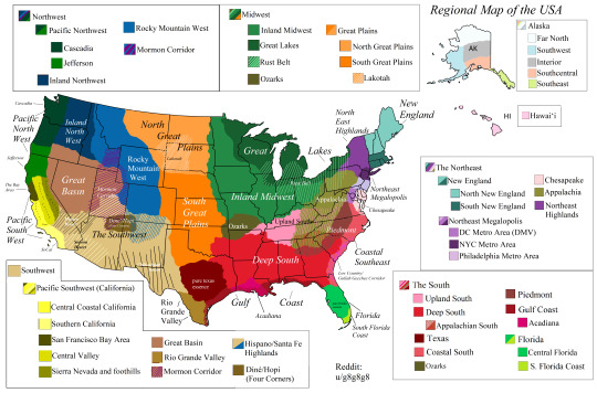
Regional map of the USA
Hello, I made this regional map of the USA, after doing research and getting a lot of suggestions from people from all across the country. Tell me what you think, and hope you enjoy!
2K notes
·
View notes

Text
Student Blog Posts from Natural Disasters Class (Dec 2019)
My GEO333 (Global Perspectives on Natural Disasters) students wrote some interesting blog posts this year! Check them out below:
Avalanches Global Avalanche Patterns Colorado Avalanche Mitigation Efforts reliance of Quality Geological Data
Disaster Planning Disaster Preparedness in Cuba Natural and Artificial Mitigation Natural Disasters: A threat to global economic convergence? Using Technology for Hurricane Mitigation and Relief Sustainable disaster management, rehabilitation and reconstruction in Tokyo Capital Region Tornado Education in Schools: How and Why Natural Disaster Resilience In Cuba
Earthquakes What Goes Up Will Come Down: Development and Earthquake Preparedness in San Francisco Earthquake mitigation in San Francisco: A Dangerous Threat with No Warning Earthquakes in Indonesia vs. California Earthquake Management in the Bay Area Mexico City and its Earthquake Problem Shaky Seattle: Planning for Earthquakes Fighting the Megaquake
Flooding Tucson, Arizona: Sun-Drenched, or Just Drenched? Flooding in New Orleans
Hurricanes Race, Ruin, and Reconstruction: Sociological Implications of Hurricane Katrina Hurricane Impacts in the Bahamas and the Outer Banks
Regional Hazards Natural Hazards of Iceland: Volcanoes, Earthquakes, and Avalanches, Oh My! A Brief Summary Of Yellowstone National Park & The Natural Hazards That Could Occur While Visiting Winter Weather Hazards of Alaska’s Southeast and Southcentral Regions California Natural Hazards Florida's Evacuation and Preparedness for Hurricanes How better regulation of nuclear power plants can enhance the health of the population in Japan Water Management & the Netherlands: a study Snow Hazards in Russia and Possible Solutions Responding to Wildfires in California
#GEO333#natural disasters#student work#Miami University#geography#earthquake#flood#volcano#wildland fire#disaster planning#avalanche#tropical cyclone
1 note
·
View note
Link
I don’t think I ever shared this here on tumblr. We were invited to write this article for The Conversation Africa last Spring. It includes a link to our paper in Remote Sensing (from January).
0 notes
Photo

Arable land as a percent of total land area in African countries
175 notes
·
View notes
Photo

Neighborhoods of New York City
285 notes
·
View notes
Text
Uptick in Amazon Fire Activity in 2019
NASA - EOS Terra Mission patch / NASA - EOS Aqua Mission logo. Aug. 24, 2019
Amazon Fire August 19, 2019
With the fire season in the Amazon approaching its midpoint, scientists using NASA satellites to track fire activity have confirmed an increase in the number and intensity of fires in the Brazilian Amazon in 2019, making it the most active fire year in that region since 2010. Fire activity in the Amazon varies considerably from year-to-year and month-to-month, driven by changes in economic conditions and climate. August 2019 stands out because it has brought a noticeable increase in large, intense, and persistent fires burning along major roads in the central Brazilian Amazon, explained Douglas Morton, chief of the Biospheric Sciences Laboratory at NASA’s Goddard Space Flight Center. While drought has played a large role in exacerbating fires in the past, the timing and location of fire detections early in the 2019 dry season are more consistent with land clearing than with regional drought.
EOS Aqua satellite. Image Credit: NASA
“Satellites are often the first to detect fires burning in remote regions of the Amazon,” Morton said. NASA’s primary tool for fire detections since 2002 has been the Moderate Resolution Imaging Spectroradiometer (MODIS) instruments on the Terra and Aqua satellites. At this point in the fire season, MODIS active fire detections in 2019 are higher across the Brazilian Amazon than in any year since 2010. The state of Amazonas is on track for record fire activity in 2019. Morton noted that 2019 fire activity statistics distributed by NASA and Brazil’s Instituto Nacional de Pesquisas Espaciais (INPE) are in agreement. “INPE also uses active fire data from NASA’s MODIS sensors to monitor fire activity in the Brazilian Amazon,” Morton said. “As a result, NASA and INPE have the same estimates of changes in recent fire activity. MODIS detections are higher in 2019 than at this time last year in all seven states that comprise the Brazilian Amazon.”
EOS Terra Satellite. Image Credit: NASA
MODIS fire detections are analyzed by the Global Fire Emissions Database (GFED) project, which includes Morton and colleagues from NASA Goddard, the University of California, Irvine, and Vrije Universiteit Amsterdam. Over the years, the GFED team has processed 17 years of NASA satellite data to better understand the role of fire for changes in the Earth system. Their analysis of the southern Amazon includes parts of Brazil, Peru, and Bolivia that typically see fires between July and October. Their data plots are available online here: https://www.globalfiredata.org/forecast.html
January 1, 2012 - August 21, 2019
January 1, 2012 - August 21, 2019
These plots show cumulative active fire detections from MODIS and the Visible Infrared Imaging Radiometer Suite (VIIRS) on Suomi NPP through August 22, 2019. The data confirm that 2019 is the highest fire year since 2012 (the start of the VIIRS record) across the seven states that comprise the Brazilian Amazon. In addition, fires in 2019 are more intense than previous years, as measured in terms of cumulative fire radiative power.
January 1, 2012 - August 21, 2019
January 1, 2012 - August 21, 2019
On August 19, 2019, the MODIS instrument on NASA’s Terra satellite captured a natural-color image (top of the page) that shows fires burning in the vicinity of Novo Progresso in the Brazilian state of Pará. The town is located along BR-163, a straight north-south highway that connects farmers in the southern Amazon with an ocean-going port on the Amazon river in Santarém. Pasture and croplands are clustered around the highway in ordered, rectangular plots. To the west of the highway, winding roads connect a series of small-scale mines that extend deep into the rainforest.
August 15 - 22, 2019
The map above shows active fire detections in Brazil as observed by Terra and Aqua MODIS between August 15-22, 2019. The locations of the fires, shown in orange, have been overlain on nighttime imagery acquired by VIIRS. In these data, cities and towns appear white; forested areas appear black; and tropical savannas and woodland (known in Brazil as Cerrado) appear gray. Note that fire detections in the Brazilian states of Pará and Amazonas are concentrated in bands along the highways BR-163 and BR-230. Since 2003, MODIS sensors on NASA’s Aqua and Terra satellites have made daily observations of thermal anomalies (usually fires) around the world. The fire detection map on this page is based on data from the Fire Information for Resource Management System (FIRMS), a product developed by the University of Maryland and NASA’s Applied Sciences Program. FIRMS provides near-real-time fire information to natural resource managers and researchers. Note that each point on the map does not necessarily correspond to one fire on the ground. Active fire detections represent the center of a 1 square kilometer area with one or more thermal anomalies. Sometimes one continuous fire can be recorded as multiple anomalies arranged in a line, representing a fire front. NASA Earth Observatory images by Joshua Stevens, using MODIS data from NASA EOSDIS/LANCE and GIBS/Worldview, Fire Information for Resource Management System (FIRMS) data from NASA EOSDIS, and data from the Global Fire Emissions Database (GFED). Story by Adam Voiland, with information from Douglas Morton (NASA’s Goddard Space Flight Center). References & Resources: - Arima, E. et al. (2016) Explaining the fragmentation in the Brazilian Amazonian forest. Journal of Land Use Science, 11 (3), 257-277. https://www.tandfonline.com/doi/abs/10.1080/1747423X.2015.1027797 - Global Fire Emissions Database (2019, August 23) Amazon Forecast: Totals. Accessed August 23, 2019. http://www.globalfiredata.org/forecast.html#totals - Global Forest Watch (2019) Fires. Accessed August 23, 2019. https://fires.globalforestwatch.org/home/ - Institute of Environmental Research in Amazonia (2019, August 22) Technical note — Amazon on fire. Accessed August 23, 2019. https://ipam.org.br/bibliotecas/technical-note-amazon-on-fire/ - Instituto Nacional de Pesquisas Espaciais (2019) Situacao Atual. Accessed August 23, 2019. http://queimadas.dgi.inpe.br/queimadas/portal/situacao-atual - NASA Earth Observatory (2013) World of Change: Amazon Deforestation. https://earthobservatory.nasa.gov/world-of-change/Deforestation - The Globe and Mail (2018, January 26) The Road. Accessed August 23, 2019. https://www.theglobeandmail.com/news/world/amazon-rainforest-deforestation-crisis/article37722932/ - NASA (2019) Fire Information for Resource Management System (FIRMS) Accessed August 23, 2019. https://firms.modaps.eosdis.nasa.gov/ - University of Maryland (2019) MODIS Active Fire Products and Burned Area Products. Accessed August 23, 2019. http://modis-fire.umd.edu/index.html - Van Marle, M.J.E. et al. (2017) Fire and deforestation dynamics in Amazonia (1973-2014). Global Biochemical Cycles, 31 (1), 24-38. https://doi.org/10.1002/2016GB005445 Related article: NASA’s AIRS Maps Carbon Monoxide from Brazil Fires & Cross Country Smoke https://orbiterchspacenews.blogspot.com/2019/08/nasas-airs-maps-carbon-monoxide-from.html Related links: Moderate Resolution Imaging Spectroradiometer (MODIS): https://modis.gsfc.nasa.gov/about/ Terra satellite: http://terra.nasa.gov/ Aqua satellite: http://aqua.nasa.gov/ Instituto Nacional de Pesquisas Espaciais (INPE): http://www.inpe.br/ Global Fire Emissions Database (GFED): https://www.globalfiredata.org/index.html Fire Information for Resource Management System (FIRMS): https://earthdata.nasa.gov/earth-observation-data/near-real-time/firms/about-firms NASA EOSDIS: https://earthdata.nasa.gov/earth-observation-data/near-real-time/firms Images, Text, Credits: NASA/GSFC/JPL. Greetings, Orbiter.ch Full article
35 notes
·
View notes
Photo

A map without New Zealand, by Russia Today.
869 notes
·
View notes
Photo

Fueling the Fire: Trump thinks logging will stop the burning in California. It won’t.
#fire#wildland fire#wildfire#fire policy#California#Woolsey Fire#Camp Fire#2018 fires#GEO333#GEO444#wildland urban interface#Stephen J Pyne
0 notes
Photo

Huge reduction in meat-eating ‘essential’ to avoid climate breakdown
Major study also finds huge changes to farming are needed to avoid destroying Earth’s ability to feed its population
0 notes