
The Bay Circuit Trail is a 200 mile trail that rambles through beautiful lands from Plum Island on Massachusetts' North Shore to Kingston on the South Shore. I'm hiking it because I love a long walk and to get back in shape. See baycircuittrail.org for maps and info.
Don't wanna be here? Send us removal request.
Statistics
We looked inside some of the posts by spellmje and here's what we found interesting.
Average Info
Notes Per Post
2K
Likes Per Post
899
Reblog Per Post
620
Reply Per Post
2
Time Between Posts
2 days
Number of Posts By Type
Text
15
Photo
2
Last Seen Tumblr Blogs


Fun Fact
25% of US internet users with an annual income of $80-100K use Tumblr.
Text
But wait... there’s more
Bay Circuit Trail section 8
We live in one of the prettiest towns on the Bay Circuit Trail, and have been ambling around since we finished in Kingston.

Amber passing a large fallen tree along Bay Circuit Trail in Wittenborg Woods, Framingham

Sadness. It has been a few years since I last hiked through the Wittenborg Woods and was saddened to see all the houses and backyards where there used to only be forest. This used to be a lovely overlook, now blocked by a chain link fence and tracks of heavy equipment probably to build another pretentious McMansion.

Henry’s Hill on the Bay Circuit Trail in Framingham

Bay Circuit Trail in Callahan State Park, Framingham

Beebe Pond, Framingham

Sudbury Reservoir, Framingham/Southboro


Fisherman catches a bass along the Bay Circuit Trail at Sudbury Reservoir
3 notes
·
View notes
Text
Day 30: Kingston Finish
Bay Circuit Trail section 14
I finished over a week ago, but have kept procrastinating making the last entry. I don’t want it to be over. But I go back to work tomorrow, and I do want to finish this lovely project.
We didn’t have much left to finish in Kingston.

Working cranberry bogs in Hathaway Preserve on the Bay Circuit Trail

The Jones River in Sampson Park

Kingston Bay, the Southern Terminus of the Bay Circuit Trail
The cast of characters:

hikers

Amber won’t take selfies, but here she is at Kingston Bay.
2 notes
·
View notes
Text
Day 29: Framingham
Bay Circuit Trail section 8
This is probably confusing, but Kingston is an hour and 20 minutes away and it hasn't been convenient to get there. So today Amber and I did parts of the Bay Circuit Trail that are conveniently close to home.
I may be prejudiced, but the Framingham section of the Bay Circuit Trail is awesome. For all the years that I have been hiking the trails in Framingham, I had never done the Bay Circuit Trail traverse of the Knox Boy Scout camp property from Route 20 to Brimstone Ln.

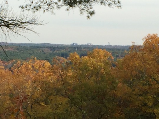
it was sunny, clear, and nippy. It was a great climb up to Tippling Rock.

The air was very clear and I could see the skyscrapers in Boston, but I didn't get a good picture.

A panorama view from Tippling Rock.

A beautiful walk through the uplands of the Boy Scout camp on our way to the summit of Nobscot Mt. There were views to the east along practically the entire trail.

After we crossed the summit of Nobscot, we had views to the west of Mount Wachusett.

This part of the Bay circuit trail was routed closer to my home that I realized. It was fun to look at the map and see how close I was to places I knew.

We took a short side trail to Ford’s Folly, a stone dam that never held water. Now it has a double chain link fence across the top for safety, and you can walk across it. The water is a long way down.

I stopped to take a picture of the side trail that goes toward a road near my house. While I was taking the picture, Amber rested, as usual for late in the day. I walked on, then noticed she wasn't in front of me. I looked back, and saw she had gone on strike. She looked at me defiantly, and didn’t budge. I know when compromise is called for, so I walked back, gave her a treat and some water, and decided to check out the neighborhood. We walked off the trail, through new developments of McMansions, down a street, through a few backyards, and down our driveway. She started sniffing around the cars, as if wondering why that yard smelled like her. As I walked down the walkway to the house, she broke into a big grin and ran to the front door. I don't think she realized until that point that she had just walked home.
1 note
·
View note
Text
Day 28: Kingston
Bay Circuit Trail section 14
We got a very early start with the intention of finishing. It was quite cold, almost freezing when we started in Pembroke.

More cranberry bogs returning to wild.


Most of the day was walking on sand. I was constantly reminded of how close we are to Cape Cod, and glacial moraine.

The Tubbs Meadow Preserve is old cranberry bogs returning to wild. Evidence of old bog canals and the ponds that filled them, and the dikes that created the ponds.

We drove a roadwalk, then headed into Veteran’s Commemorative Town Forest. This is where I made my key mistake of the day. I took a look at the turn by turn directions, hastily calculated the mileage, and said we had a 4 1/2 mile walk so we could travel light, with one bottle of water for the three of us, and lunch when we got back to the cars. Actually, we had a 7 1/2 mile walk. I miscalculated when the mileage reset to zero at the Kingston town line.
In the category of strange stuff that people drag into the woods, we discovered what appeared to be a skeet launcher along a powerline walk.


Old barn with Bay Circuit Trail markers in Silver Lake Sanctuary.

Silver Lake

Pond next to Silver Lake Regional High School. The water tower on the high school grounds is visible to the left.


Evidence of Cranberry Farming Past: old barn and overgrown bog canal in Cranberry Preserve.
By the time we got to Cranberry Preserve, our hike was beginning to feel like a death march, so we decided to save the last 3 miles for another day.
1 note
·
View note
Text
Day 27: Hanson & Pembroke
Bay Circuit Trail section 13
it was cold today in the low 40s. I think that's why we walked so quickly. Today was a beautiful day full of cranberry bogs.

We started with a boardwalk crossing of the Poor Meadow Brook wetlands. A small section had fallen because someone had started a fire on the boards – or so it appeared.

Then we walked through the Burridge Pond Wildlife Management Area. We walked through cranberry bogs and along the Indian Crossway trail. The turn-by-turn directions said there was a “gap” in the trail. The gap wasn't a landowner right-of-way, it was a stream that needed bridging! Fortunately, there were side trails that allowed us to cross at a narrow point in the stream and returned to the trail through the Light Control Property.
We had lunch in the car, and warmed up. Tim had brought an egg for lunch. Joking around, he cracked it on his forehead. It was not a hard-boiled egg! I laughed for a very long time.
After a quick loop through the Hansen Town Forest, we headed into Camp Kiwanee. This lovely trail wound between ponds and around cranberry bogs.


We followed the white blazes away from the cranberry bog which took us to a road walk which wasn't on the map. It must've been the old route. We turned around and went back to the cranberry bog, and followed the correct trail out to the Andruk bogs. These are cranberry bogs which are going back to nature. The canal was lovely.

I'm very excited, because we are doing section 14 tomorrow, ending at the Atlantic Ocean in Kingston Bay. That is the southern terminus of the Bay Circuit Trail.
3 notes
·
View notes
Text
Day 26: the Bridgewaters
Bay Circuit Trail section 12
Yay! Yesterday I got my cast off, and today I am walking with just a wrist brace. Ah, the freedom to scratch!
It was cold and rainy today, and which worked pretty well for driving road walks and warming up. The Bridgewaters had only a few forested areas with a lot of road walk, but what they had was exceptional.

Amber and I started out the morning completing the Hockomock Swamp, which was a powerline walk like the previous day. Today, the swamp was full of birdsong – many different species. I missed having a bird book with me. A cacaphony of a black birds were clustered in a few trees.

The problem with Hockomock Swamp is that the utility line service road is accessible to other vehicles as well. People drag some strange stuff into the woods: sofas, recliners, huts, teepees, and lots of trash. Today I saw a life-sized, white plastic female torso hanging from a utility tower, shot full of bullet holes. It creeped me out.

I packed out a overflowing bag of trash.
We next hiked a new section of the BCT, Haseotes-MassWildlife off Scotland Road. It was just under a mile long, paralleling the river and farmland. We passed the Skim Milk Bridge, an old stone bridge over Town River.
We turned around to go back at the Solitude Stone, a boulder with poetry carved in it next to a bench on the side of the river.

We next took a break to amble around War Memorial Park in West Bridgewater and admired the beautiful stonework restraining the river, the beautiful stone arches on the bridges, and the fish ladders. The Bridgewater Ironworks Park at Stanley had similar work.

We ended the day racing sunset in the Satucket River Conservation Area. I would like to go back and do this short walk again in better weather. The BCT followed the Satucket River, then rambled through some beautiful pine forest.

3 notes
·
View notes


Text
Day 25: Easton
Today had short woods walks interspersed with long road walks. We walked through the woods and back to the car, then drove along the road walks, and got out and walked again. We walked 9 miles all told.
Our first hike was a short walk to Old Pond, Easton. Amber got a swim. It is the site of an old mill, with an old millstone to commemorate the site.

Bay Circuit Trail by Old Pond, Easton.

Old Pond, Easton

Millstone and plaque at Old Pond
Next, we walked through Wheaton Farm. Fields, forest, a pine grove, and a lake with 2 swans.


Old, broken fence along Bay Circuit Trail in Wheaton Farm, Easton
I almost skipped our last walk of the day because I thought it would be another boring powerline walk. I'm so glad we went. We walked the powerline service road through a beautiful swamp on either side. Brilliant red berries and swaying cattails. Sometimes the crackle! zinng! of electricity overhead. Chickadees, jays, and the kiii of a raptor.

Red berry bush. In the background is a green hillside farm of solar panels.

Towering cattails, at least 10 feet high.

Open water, perhaps a brook in the swamp.

Bird tracks in the sand.
Clouds had been threatening rain all day, but it held off until we were 15 minutes from the car. Just a little damp to end the day.
3 notes
·
View notes
Text
Day 24: Easton
Bay Circuit Trail section 11
Borderlands State Park is pretty in Easton, too! I parked at the Visitor Center where we abruptly ended on Saturday. It’s a good thing, too! We would not have made it to the car before dark, let alone making Tim’s 4:30 deadline.
But today was sunny in the low 60s. Amber and I headed south without a clear idea of where we were going to finish. When my various attempts to find a ride fell through, I decided to head for Beaver Brook Woods and turn around and come back to Borderlands and my car.

The Bay Circuit Trail goes past the grand lawns of Ames Mansion in Borderlands State Park.

Some variety of cattail in Borderlands State Park.

With all the leaves off the trees and uniformly covering the ground, it was sometimes difficult to tell where the trail actually was.
After leaving Borderlands, the trail followed utility lines.

The trail was dry and very rocky under the power lines. I brushed against this dried shrub which made a musical sound similar to brushes on the snare drum. When I got close to take a picture, I saw that it was covered with tiny dried seedpods producing that delightful sound.

When we stopped for lunch after leaving the power lines, I did a calculation of the time and realized that we needed to make it to our turnaround point, Beaver Brook, by 1:30 in order to make it back to Borderlands by 4 o'clock when the parking lot closed. We made it to Beaver Brook by 1:32, and immediately turned around and hurried back.
I did not take into consideration how much faster we could go when Amber knew the way! No searching for blazes, no map reading, and motivation of making it back to Borderlands on time. Even the tricky turn exiting the power lines into the brush, Amber was waiting right at the trail turn.
I was pushing a little hard for a very rocky section, when I took my first fall since breaking my wrist. Fortunately, it was a slow fall and I could tuck and roll. I laid on the rocks taking inventory, when Amber came over and licked my face until I laughed and decided I wasn't hurt at all. We made it back to Borderlands by 3 o'clock.
#hiking#bay circuit trail#trails massachusetts#easton#borderlands state park#Fox Mountain Lot#Beaver Brook Woods
3 notes
·
View notes
Text
Day 23: Sharon – Borderland State Park
It's amazing how different things were after a five-day break. All the leaves were down off the trees. The woods were all grays and browns, with a few pine trees for color.

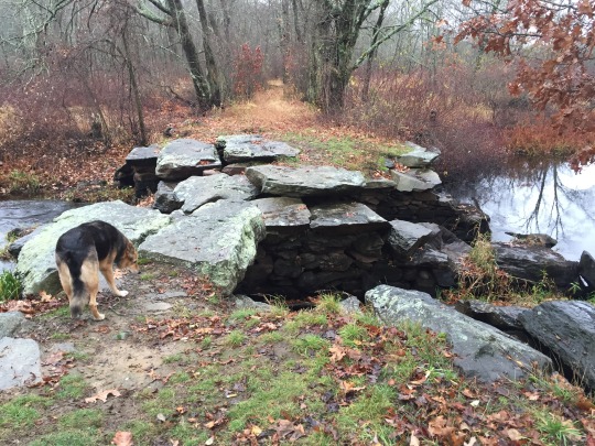
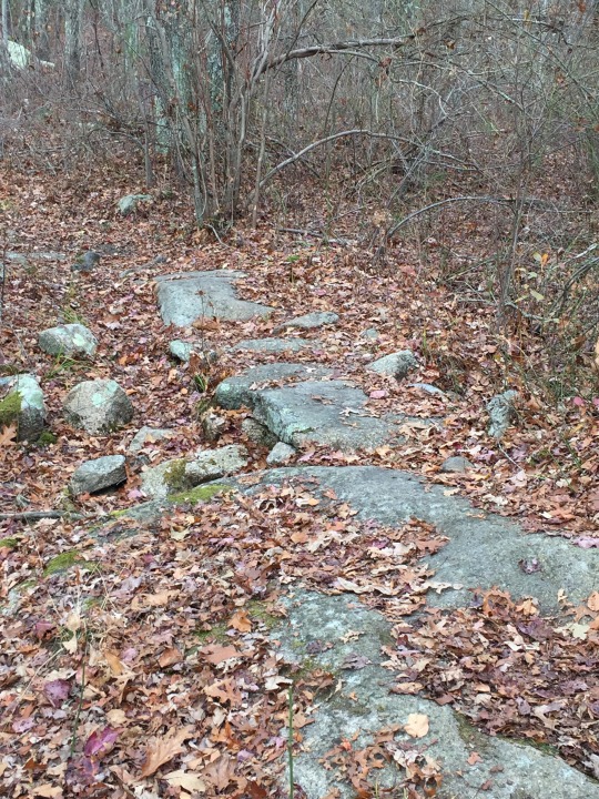
We started at Massapoag Lake, did a short road walk, and spent the rest of the day in Borderlands State Park. Borderlands was really rocky, with lots of granite outcropping, boulders, and little rocks sometimes poking out of leaves. I had to do careful walking.
Tim spotted subtle rock bridges along the trail, beautifully designed, that merged into the landscape. He had to point them out to me because I never saw them.
Rock bridge on Bay Circuit Trail, Borderlands State Park
We passed one devastated landscape where it appears that a beaver dam had been drained, leaving all the muck and the drowned trees sticking up.

Amber was so excited to be back hiking again. She was running ahead and jumping up and down off rocks as if she had boundless energy. She had a big grin all day. For me, it was really nice to be walking on an overcast day with cool weather. During my hiatus, I had four days of sun and temperatures in the 90s, so a 60° day was just lovely.
2 notes
·
View notes
Text
Day 22: Sharon
Bay Circuit Trail section 10
Today is Halloween and a Saturday so Tim and his sister Margaret both joined Amber and I. We decided the costumes were optional but silly hats were required. In the tradition of belts and suspenders, Tim brought a silly hat and a silly wig. We met Margaret in Sharon. She had metallic blue hair. I wore a red medieval hood.
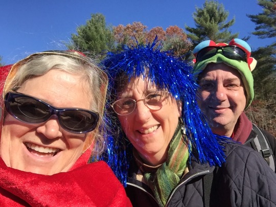
Jeanne, Margaret, and Tim ready for Halloween
We walked past a 1973 underground house that was pretty cool looking. "A labor of love" was an engraved on the rock sitting on top of the house.

We climbed up to Allen's Ledge and Bluff Head with with spectacular views toward Foxboro.We then climbed to the summit of Moose Hill, the highest point on the Bay Circuit Trail, which had a fire tower but no view. But we did have lunch.

The forests in Moose Hill Wildlife Sanctuary were varied and colorful.


We walked for a short time alongside railroad tracks. We heard a train coming, which turned out to be the commuter rail. A few minutes later, we heard another train and I reached for my phone. But this was the Acela high-speed train, and it swooshed by long before I could take a picture.
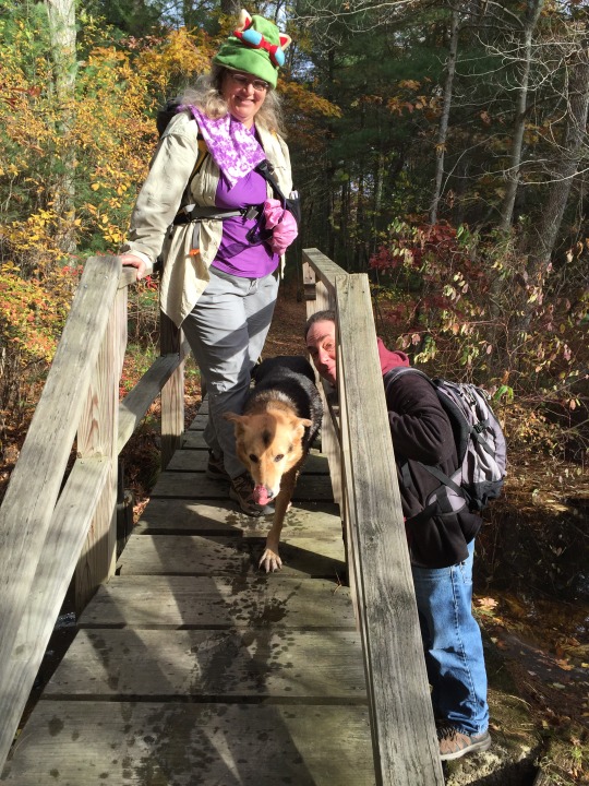
We crossed Beaver brook where Amber got her only swim of the day.
Near the end of the day we saw an amazing kid-built treehouse a long distance from a road.

We ended up the day at Deborah Sampson Park.
1 note
·
View note
Text
Day 21: Walpole
Bay Circuit Trail section 10
I will stop criticizing Medfield -- I drove by the construction site today and all the heavy equipment was gone. It has probably moved on to Walpole.
Amber and I did a short (3 mile) hike today along the Neponset River. The trail was cruising and there were lots of places to swim.

We met a man flying a small drone photographing the river. Amber was fascinated with the buzzing object, and I restrained her from jumping off the bridge after it! He said he taught FAA-certified classes for flying drones for commercial uses. Pretty cool.

Walpole routes the Bay Circuit Trail through a DPW yard, too. We found where old fire hydrants go to die.

More great weather sunny and cool.
1 note
·
View note
Text
Day 20: Walpole
Bay Circuit Trail section 10
Summer returned today! It was 73° at 2:00 PM. Amber was very hot, but fortunately there were lots of places to swim today. We started in Medfield walking along powerlines that were in under construction with the BCT plowed up and loud noises from heavy equipment. Medfield disappointed again. But it wasn't long before we crossed the line into Walpole and within 100 yards things completely changed. The Walpole trails were spacious, beautiful, well-kept, and well blazed. I never got lost all day.

We recrossed the powerlines as we entered Walpole but it was peaceful and quiet with sweeping views.
However, I was expecting an esker walk – which we got, but not in the way I expected. We went up and down and up and down and up and down all day long. It was quite a workout! Amber would run up the hill, sit down, look back at me and laugh with that big doggy smile. And then she would run down the next section, and laugh at me again. Humans are so slow.

Mine Brook in Walpole
She found her first muddy pond along a road walk in Medfield, then a stream to wash the mud off. After we entered Walpole, there were brooks and streams all day long. We had a break at a teenagers hang out in the woods overlooking Mine Brook. Someone had even brought a wicker couch. This was not close to a road that I could tell. The wind had picked up and kept blowing my hat off, but Amber enjoyed the smells delivered right to her nose.

We had a short road walk through the center of Walpole, but then there was Memorial Pond for swim. Then another walk in the woods, and then Clark Pond for another swim. We ended the 8 mile day with a short road walk to Walpole High School where Maura was waiting for us. Amber chased squirrels all the way along Lake Ave. I don't know where she got the energy, I was dragging. But it was a great day.
0 notes
Photo


Bay Circuit Trail in Medfield and Walpole (individually captioned)
0 notes
Text
Day 19: Medfield
Bay Circuit Trail section 9
We had a late start this morning, after I took Amber to the vet for a checkup. She got a clean bill of health and had lost some weight. The vet was very impressed with her adventures. Then I took her to the doggie spa to get her nails trimmed.
Medfield redeemed itself from yesterday with the lovely Shattuck Reservation and Noon Hill Reservation. The Bay Circuit Trail parallels the Charles River through Shattuck, then climbs to the Noon Hill overlook.

Amber took a swim in the Charles River
of course I got lost again, this time from following the white and red blazes I had been following all morning. We went through brambles and tick habitat. UGH!!! I finally realize that we had been following a boundary marker and not the trail. We bushwhacked toward the sound of a road and ended up in someone's backyard. From there we navigated back to the trail.
We climbed toward Noon Hill as the sun was getting low. It was a great view from the summit. I was chatting with a woman my age at the summit about hiking the Appalachian Trail. We exchanged phone numbers. She explained that the strange looking structure I could see on the horizon was actually Gillette Stadium in Foxboro. She pointed out Blue Hills, but I can't say I saw it.
Gillette Stadium from the summit of Noon Hill
We quickly hiked down Noon Hill to meet Maura who gave us a ride back to our car. It was great to see her.
2 notes
·
View notes
Text
Day 18: Medfield
Bay Circuit Trail section 9
Today was a day for getting lost. Absolutely gorgeous day – clear blue skies, cool in the 50s – there couldn’t be a nicer day. But I had foreboding as I was packing in the morning. This is the first day I didn’t want to go hiking.
I was by myself today, as Amber needed a rest, and there were a lot of roadwalks. I started at the Charles River at the Sherborn-Medfield line. From the very first moments in the parking lot, I couldn’t find the trail. That should have been a warning to me. I headed down to the river and admired the Charles, but the trail ended there. I retraced my steps about 10 yards and spotted a blaze deep in the woods. The trail was pretty overgrown and hard to find. Worse, there were lots of gunshots, and the sounds of a hunter calling to his dog. I blew my whistle and contemplated how much orange I was NOT wearing.

The Charles River in Medfield

Crossing the railroad tracks on Hospital Road
Most of the trail was not well marked. I wandered around the old Medfield State Hospital site for quite some time – lots of intersecting trails and mysterious patches of asphalt – before I pulled out Google maps and headed for the nearest road.

Former site of Medfield State Hospital
Then I spent some time wandering around two baseball fields looking for the trail entrance. The directions said to turn right at the baseball field. After circumnavigating the baseball fields, I discovered that the correct direction was to turn left. After a charming road walk through industrial Medfield – a strip of decaying warehouses – I turned into the woods from West Street. This was well blazed, which was a good thing, because I ended up bushwhacking from blaze to blaze. The trail circled a landfill (ugh!) and came out at a DPW site. Medfield was not showing me its best side.

BCT crossing the Medfield DPW yard
Vine Lake Cemetery was very peaceful and pretty. I waved to an elderly gentleman tending a grave with his car nearby with the radio blasting a sports channel. Once again I missed a turn and ended up on a completely different street. Fortunately it wasn't hard to navigate to the correct location, but that added to the next road walk.

The pond at Vine Lake Cemetery
Causeway Road had some nice views of wetlands, but it was the worst kind of road walk: narrow road, no shoulder, fast-moving traffic.

Accident death marker on Causeway Road
Tim came to pick me up just as the trail was leaving the road, so I'll save that for tomorrow.

Stop River from Causeway Road
2 notes
·
View notes
Text
Day 17: Sherborn
Bay Circuit Trail section 9
A rainy Sunday morning, and Tim, Amber, and Jeanne were all tired. We decided to hike the Rocky Narrows section of Sherborn as a short day. It was lovely. The rain stopped pretty soon after we got hiking, and it was an overcast day.

Amber takes a swim in the Charles River

We had lunch at Rocky Overlook, overlooking the Charles.

We then hiked to King Philip's Overlook, with some lovely views.
2 notes
·
View notes