#DataDrivenSecurity
Explore tagged Tumblr posts
Visit Tumblr Blog
Explore Tumblr blogs with no restrictions, modern design and the best experience.
Last Seen Tumblr Blogs


Fun Fact
Tumblr has 4 main sources of revenue.
Text
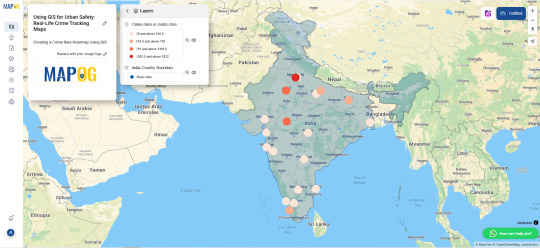
GIS for Urban Safety with Interactive Crime Mapping

Interactive, GIS-powered crime maps deliver essential spatial insights for bolstering urban safety. By displaying crime data in real life, these platforms enable law enforcement and city planners to pinpoint high-risk areas, anticipate emerging trends, and allocate resources more effectively—melding public records with advanced geospatial analysis.
Why Use GIS for Crime Prevention?
GIS streamlines crime analysis by overlaying incident reports with environmental, demographic, and infrastructure layers. Moreover, these scalable solutions support predictive policing, informed patrol deployment, and robust community outreach through location-based crime intelligence.
Uses of GIS in Urban Safety
Hotspot Detection – Reveal clusters of criminal activity, guiding officers to the areas that need attention most.
Predictive Policing – Identify patterns in past incidents to forecast where future offenses may occur.
Public Safety Planning – Inform neighborhood design by integrating crime data into urban development decisions.
Key Applications
Community Awareness: Offer citizens up-to-date crime information via interactive dashboards.
Patrol Optimization: Reconfigure patrol routes according to crime density and urgency metrics.
Traffic Incident Mapping: Enhance road safety by mapping collisions and traffic-related offenses.
Procedure for Crime Mapping with GIS
First, compile crime statistics and geo coordinates from authoritative sources by adding a boundary layer. Next, add CSV/Excel file containing city names and their latitude–longitude pairs. Then, create a “Crime Rate” attribute in the layer’s schema and input the corresponding values for each location. Afterward, switch to the style settings and enable the “Bubble Map” visualization. Adjust classification breaks for clarity and assign a bubble radius of 20 for optimal display. Using tools like MAPOG, merge administrative boundaries and fine-tune symbology for clear overlays. Finally, review the map, publish it to your GIS portal, and share the interactive link with stakeholders.
Use Case: School Zone Safety and Youth Protection
GIS crime mapping is increasingly used to safeguard areas around schools by analyzing incidents involving theft, bullying, or drug-related activity near educational institutions. By combining spatial crime data with student commute routes, pedestrian crossings, and traffic flow, city officials can implement targeted interventions such as increased surveillance, better lighting, and adjusted traffic patterns. This application not only helps create safer school zones but also strengthens policies aimed at protecting young populations in vulnerable urban pockets.
Open-Source GIS Tools in Crime Analysis
Open-source platforms such as MAPOG enable municipalities to develop transparent, shareable crime maps. These tools enhance civic participation, facilitate data sharing, and improve real-life public safety coordination.
Conclusion
By harnessing interactive GIS mapping, cities can revolutionize crime prevention and response. With spatial data and dynamic visualizations, decision-makers gain the insight needed to deploy resources swiftly, engage communities effectively, and ultimately create safer, more resilient urban environments.
#UrbanSafety#CrimeMapping#GISforSafety#SmartPolicing#SafeCities#GeospatialTech#PredictivePolicing#CommunitySafety#SmartMapping#DataDrivenSecurity
1 note
·
View note
Text
Stay Ahead of Fraud with Predictive Analytics in Fintech
In today's digital finance world, fraud moves fast but predictive analytics moves faster.
Learn how predictive analytics for fraud detection in fintech empowers businesses to: 🛡️ Spot suspicious activities before damage is done 📈 Minimize risks and boost customer trust ⚙️ Leverage machine learning for real-time decision-making
Whether you're a fintech founder, fraud analyst, or CTO, this blog reveals how data-driven strategies are becoming the new defense shield for financial institutions.
#PredictiveAnalytics#FraudDetection#FintechInnovation#DataDrivenSecurity#FraudPrevention#FintechSolutions#RiskManagement#MachineLearningInFintech#DataScienceForFinance#DigitalBanking#KodyTechnolab#FinancialTechnology#CyberSecurity#FutureOfFintech
0 notes
Text

🌐Cybersecurity Meets📊Data Analytics – A Game Changer! 🦹Cybercriminals are getting smarter, but Data Analytics is one step ahead! With real-time data insights, businesses can detect and prevent threats before they cause damage. 🧐How does Data Analytics work in Cybersecurity? 👉Threat Detection 👉Behavioral Analytics 👉Incident Response 👉Fraud Prevention 🔐 Stay safe, stay protected with Data Analytics! 📈🤝Want to master Data Analytics and transform industries? Start your journey today! 🚀 🌟Why Choose Data Analytics Masters?🌟 ✔ 100% Job-Oriented Program – Learn skills that get you hired! ✔ Expert Faculty – Learn from industry professionals. ✔ Real Projects – Work on live industry datasets. ✔ Flexible Learning – Online & offline options available. ☎ Contact us ☎ 📞+91 9948801222 💻www.dataanalytics.in 📧[email protected] 🚀 Join Data Analytics Masters and start your career in Data Analytics today
#StaySafeOnline#AIinCybersecurity#ThreatDetection#CyberDefense#DataDrivenSecurity#IncidentResponse#FraudPrevention#digitaldefense#CyberSecurity
0 notes
Text

Empower Your City with Advanced Safety and Security Solutions
At Xtreme Utility Consulting, we’re redefining urban safety with cutting-edge Smart City Deployment. Our advanced solutions are designed to elevate safety and security across cities and counties, ensuring a safer environment for all residents.

Transform your city's approach to safety and security with innovative Smart City technologies. Partner with Xtreme Utility Consulting to build a safer, smarter future!

#SmartCityDeployment#UrbanSafety#XtremeUtilityConsulting#CitySecurity#EnhancedSurveillance#EmergencyResponse#DataDrivenSecurity#SafeCommunities#InnovativeSafety#CityTransformation#SmartCityTech#SecureFuture#UrbanInnovation#SmartCitySolutions#EmpoweredCities
0 notes
Text
Tailgating Detection Systems: A $3.4 Billion Market by 2034 – Securing the Future
Tailgating Detection System Market is expanding rapidly as organizations prioritize security and regulatory compliance. These systems use sensors, cameras, and AI-driven software to detect unauthorized access, ensuring enhanced perimeter security in commercial, government, and industrial sectors.
To Request Sample Report : https://www.globalinsightservices.com/request-sample/?id=GIS24455 &utm_source=SnehaPatil&utm_medium=Article
Among key segments, hardware solutions, including sensors and cameras, lead the market due to their role in real-time monitoring and access control. The software segment, particularly video analytics and management platforms, follows closely, emphasizing data-driven security enhancements.
North America leads the market, with strong adoption of advanced security technologies. Europe ranks second, with Germany and the UK driving growth through strict security regulations and increasing investments in public safety infrastructure.
Key Market Segments
✅ By Type: Active Systems, Passive Systems ✅ By Product: Hardware Solutions, Software Solutions, Integrated Solutions ✅ By Technology: Infrared, Ultrasonic, Video-Based, Biometric Technology ✅ By Application: Commercial Buildings, Government Institutions, Transportation Hubs ✅ By Functionality: Detection, Monitoring, Access Control, Intrusion Prevention
In 2024, the market volume reached 320 million units, with projections to grow to 520 million units by 2028. Video analytics dominates (45%), driven by AI advancements, followed by access control systems (30%) and RFID-based solutions (25%). Honeywell International, Bosch Security Systems, and Johnson Controls lead the market, innovating with AI-powered surveillance and biometric authentication.
#tailgatingdetection #accesscontrol #securitysystems #physicalsecurity #surveillance #aiinsafety #biometricsecurity #smartsecurity #buildingsecurity #infraredtech #rfidsecurity #smartaccess #cloudsecurity #perimeterprotection #videoanalytics #intrusiondetection #identitymanagement #datadrivensecurity #securefacilities #publicsafety #corporatesecurity #industrialsecurity #cyberphysicalsecurity #smartmonitoring #highsecurity #securityautomation #iotsecurity #honeywellsecurity #boschsecurity #johnsoncontrols #ultrasonicdetection #securitytechnology #governmentsecurity #securitysolutions #cloudbasedsecurity #privacymatters #aiinsecurity #futureofsecurity #businessprotection #securitycompliance
0 notes
Text

Empower Your City with Advanced Safety and Security Solutions
At Xtreme Utility Consulting, we’re redefining urban safety with cutting-edge Smart City Deployment. Our advanced solutions are designed to elevate safety and security across cities and counties, ensuring a safer environment for all residents. Why Smart City Deployment with Xtreme Utility Consulting? 1. Enhanced Surveillance Systems 2. Integrated Emergency Response: 3. Data-Driven Insights Transform your city's approach to safety and security with innovative Smart City technologies. Partner with Xtreme Utility Consulting to build a safer, smarter future! Click here to learn more: https://lnkd.in/gJT8HpTc
#SmartCityDeployment#hashtag#UrbanSafety hashtag#XtremeUtilityConsulting hashtag#CitySecurity hashtag#EnhancedSurveillance hashtag#EmergencyResponse hashtag#DataDrivenSecurity hashtag#SafeCommunities hashtag#InnovativeSafety hashtag#CityTransformation hashtag#SmartCityTech hashtag#SecureFuture hashtag#UrbanInnovation hashtag#SmartCitySolutions hashtag#EmpoweredCities hashtag#SafetyFirst#Activate to view larger image
0 notes
Text

Empower Your City with Advanced Safety and Security Solutions
At Xtreme Utility Consulting, we’re redefining urban safety with cutting-edge Smart City Deployment. Our advanced solutions are designed to elevate safety and security across cities and counties, ensuring a safer environment for all residents. Why Smart City Deployment with Xtreme Utility Consulting? 1. Enhanced Surveillance Systems 2. Integrated Emergency Response: 3. Data-Driven Insights Transform your city's approach to safety and security with innovative Smart City technologies. Partner with Xtreme Utility Consulting to build a safer, smarter future! Click here to learn more: https://lnkd.in/gJT8HpTc
#SmartCityDeployment#hashtag#UrbanSafety hashtag#XtremeUtilityConsulting hashtag#CitySecurity hashtag#EnhancedSurveillance hashtag#EmergencyResponse hashtag#DataDrivenSecurity hashtag#SafeCommunities hashtag#InnovativeSafety hashtag#CityTransformation hashtag#SmartCityTech hashtag#SecureFuture hashtag#UrbanInnovation hashtag#SmartCitySolutions hashtag#EmpoweredCities hashtag#SafetyFirst
0 notes