#GPS Navigation System
Explore tagged Tumblr posts
Visit Tumblr Blog
Explore Tumblr blogs with no restrictions, modern design and the best experience.
Last Seen Tumblr Blogs


Fun Fact
Users from the US are the majority of Tumblr visitors.
Text
0 notes
Text

With its 9-inch touchscreen display, the Kayhan Audio Car Stereo with SatNav for Chevrolet Silverado 2012 is a modern useful interior expansion. It has Bluetooth, USB, and Wi-Fi connectivity for smooth media streaming, hands-free calling, and app access. It also has GPS navigation with real-time traffic updates. With cutting-edge technology and convenience, the high-resolution screen and user-friendly interface enhance your driving experience. Website:
https://kayhanaudio.com.au/product/car-stereo-with-satnav-for-chevrolet-silverado-2012-v5-9-inch/
#V6 Car Stereo#2012 Silverado SatNav#Kayhan Audio#Chevrolet Silverado Accessories#Apple CarPlay#Android Auto#Car Entertainment System#In-Dash GPS#High-Resolution Screen#Hands-Free Calling#USB Connectivity#Chevrolet Navigation System#Car Multimedia System#Wi-Fi Car Stereo#Real-Time Traffic Updates#Chevrolet Audio Upgrade#Chevrolet Silverado SatNav#9-inch Car Stereo#GPS Navigation System#Bluetooth Car Stereo#Touchscreen Car Stereo
0 notes
Text
Satellites: Their Orbits, Tracking Systems, and Essential Uses
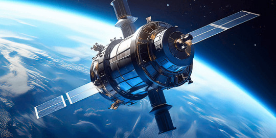
Satellites: Their Positions, Tracking, and Importance
Satellites have become an essential part of modern life, orbiting Earth and providing us with services ranging from communication and navigation to weather forecasting and space exploration. As of 2024, thousands of active satellites are circling our planet, each performing a specific role to enhance the quality of life on Earth. This article delves into the positioning of satellites, how they are tracked, what they track, and the significance of their roles.
Types of Satellite Orbits and Their Positions
Satellites are positioned in various orbits depending on their intended functions. These orbits determine how close the satellite is to Earth, how fast it moves, and what areas it covers.
Low Earth Orbit (LEO): Altitude: 180 km to 2,000 km Satellites in LEO include most Earth observation satellites, the International Space Station (ISS), and some communication satellites. These satellites are closer to the Earth, enabling them to capture high-resolution images. Functions: Used for imaging, remote sensing, and some communication purposes. Examples: ISS, Earth observation satellites like Landsat.
Medium Earth Orbit (MEO): Altitude: 2,000 km to 35,786 km Satellites in MEO are mainly used for navigation. This orbit offers a good balance between coverage and latency. Functions: GPS satellites and other global navigation systems. Examples: GPS, GLONASS, and Galileo satellites.
Geostationary Orbit (GEO): Altitude: 35,786 km above the equator Satellites in GEO move at the same rotational speed as Earth, meaning they stay fixed over one location on Earth. These are mostly communication and weather satellites. Functions: Used for television broadcasts, weather monitoring, and some types of communication. Examples: Weather satellites (GOES series), telecommunication satellites.
Highly Elliptical Orbit (HEO): Orbit shape: An elongated orbit with one point closer to Earth (perigee) and another point much farther away (apogee). Functions: Ideal for regions at high latitudes, providing prolonged coverage over areas like Russia and parts of Canada. Examples: Molniya satellites for communication in Russia.
How Satellites Are Tracked
The sheer number of satellites in space, combined with space debris, means tracking them is essential to avoid collisions and ensure their functionality. Ground stations and dedicated space agencies continuously monitor satellites. Several methods are used to track satellites:
Radar and Ground-Based Systems: Ground stations use radar to track satellites in LEO. These systems bounce radio waves off the satellite and measure the time it takes for the signal to return. By doing this repeatedly, they can track a satellite's location and speed.
Global Positioning System (GPS): Satellites in higher orbits like MEO or GEO are tracked using onboard GPS receivers. GPS helps calculate the satellite’s position and relay that data back to Earth.
Optical Tracking: Telescopes and cameras are used to visually observe satellites in higher orbits. This method is particularly useful for tracking objects that do not emit radio signals or need to be monitored for their physical characteristics.
Space Surveillance Networks: Agencies such as the U.S. Space Surveillance Network (SSN) and similar organizations in other countries continuously monitor satellites and space debris. They catalog objects and issue alerts for potential collisions.
What Satellites Track
Satellites are equipped with various sensors, cameras, and instruments to track a wide array of data on Earth, in space, and beyond:
Weather and Climate Data: Satellites such as NOAA’s GOES series monitor weather patterns, hurricanes, and long-term climate changes. They provide crucial data for meteorological services.
Earth Observation: Satellites like Landsat capture high-resolution images of Earth's surface. These images are used for mapping, agricultural planning, disaster response, and environmental monitoring.
Navigation Signals: GPS and other GNSS (Global Navigation Satellite Systems) satellites send signals that are used for navigation by smartphones, vehicles, ships, and airplanes worldwide.
Communication: Satellites facilitate global communication by relaying TV, radio, and internet signals across vast distances.
Space Exploration: Space telescopes like the Hubble Space Telescope track distant galaxies, nebulae, and black holes, helping scientists study the universe.
Military Surveillance: Many satellites are designed for defense purposes, tracking missile launches, military movements, or spying on potential threats.
Number of Satellites in Space
As of 2024, there are approximately 8,000 operational satellites orbiting Earth. The exact number fluctuates as new satellites are launched and old ones are decommissioned. Additionally, space agencies and private companies like SpaceX continue to launch large satellite constellations, such as Starlink, which alone has over 5,000 satellites in orbit for global internet coverage.
The Usefulness of Satellites
Satellites have become indispensable in modern life, serving a wide variety of purposes that impact everyday activities and critical global functions:
Key Functions of Satellites:
Communication: Satellites enable long-distance communication by transmitting data, television, and internet services. Without them, global broadcasting and real-time communication in remote areas would be impossible.
Navigation: Systems like GPS help millions of people navigate in real-time. They are also vital for the functioning of aviation, maritime travel, and even agricultural practices.
Earth Observation: Satellites provide high-resolution imagery of Earth, helping with disaster management, urban planning, agriculture, and environmental monitoring. For instance, they can track deforestation or observe glaciers' melting rates.
Weather Forecasting: Weather satellites provide the data needed for accurate predictions, storm tracking, and climate monitoring. This information is critical for preparing for natural disasters like hurricanes or floods.
Scientific Research and Exploration: Space telescopes and interplanetary satellites gather data on space phenomena, expanding our understanding of the universe. Satellites also conduct scientific experiments in the microgravity of space.
Defense and Security: Satellites are used for military surveillance, early-warning systems, and missile detection, playing a crucial role in national security.
Satellite Highlights in Brief:
Types of orbits: LEO, MEO, GEO, HEO, each serving different purposes.
Tracking methods: Radar, GPS, optical tracking, and space surveillance networks.
Data tracked by satellites: Weather, Earth observation, navigation signals, space exploration, and military surveillance.
Number of active satellites: Approximately 8,000.
Key roles: Communication, navigation, weather forecasting, Earth observation, scientific research, and defense.
In conclusion, satellites are essential tools for global communication, navigation, monitoring Earth's environment, and scientific discovery. As technology advances and the number of satellites continues to grow, their impact on our daily lives will only increase. Whether improving how we predict the weather, navigate through traffic, or explore the universe, satellites will continue to be a critical resource for humanity.
Go To How Satellites Work and What They Track
#satellite orbits#satellite tracking#satellite functions#low earth orbit#geostationary orbit#medium earth orbit#space technology#GPS satellites#communication satellites#weather satellites#Earth observation#satellite uses#satellite positions#how satellites work#space surveillance#satellite navigation#satellite networks#satellite importance#global navigation systems
7 notes
·
View notes
Text
How to Install a Mercedes-Benz Navigation SD Card
Upgrading your Mercedes-Benz with built-in navigation is easier than you might think — especially if your vehicle is equipped with the COMAND or MBUX infotainment system. With just a few simple steps, you can install a Mercedes-Benz navigation SD card and start enjoying accurate maps, real-time directions, and premium navigation features.
Step-by-Step Guide to Install the Navigation SD Card
Check Compatibility Before you begin, make sure your vehicle supports SD card-based navigation. Most models from recent years (like the C-Class, E-Class, GLC, and GLE) include an SD card slot, often located in the center console or glove compartment.
Get the Correct SD Card Purchase the official Mercedes-Benz navigation SD card that corresponds to your vehicle’s VIN and region. Using a non-compatible or outdated card may cause errors or won’t work at all.
Turn On the Ignition Start your vehicle or turn the ignition to the “On” position without starting the engine.
Insert the SD Card Insert the navigation SD card into the appropriate SD slot. The system should automatically detect the card and begin loading the navigation software.
Follow On-Screen Prompts Once the system recognizes the SD card, you’ll see setup prompts on your infotainment screen. Accept the terms and follow any additional instructions to activate the map system.
Wait for Installation The initial setup may take a few minutes. Once installed, you’ll be able to access navigation from the main menu of your infotainment system.
Final Tips
Keep the SD card inserted at all times; removing it can disable the navigation feature.
For future map updates, Mercedes offers downloadable updates via their website or by purchasing a new SD card.
Installing a navigation SD card is a quick and cost-effective way to upgrade your driving experience. Whether you’re commuting in the city or heading out on a road trip, Mercedes-Benz navigation helps you get there with confidence.
#Mercedes navigation SD card#how to install Mercedes-Benz navigation SD card#Mercedes navigation setup#Mercedes-Benz SD card installation#Mercedes navigation system#Mercedes map update#MBUX navigation#COMAND SD card#install nav card Mercedes#Mercedes GPS system#navigation activation Mercedes
0 notes
Link
For long journeys with your Audi, plan ahead and ensure your vehicle is in good condition. Here are some tips for a comfortable and safe trip. Traveling with your Audi can be a thrilling experience, especially on long journeys. However, it’s important to prepare adequately to ensure a smooth and saf...
#Lifestyle#adventure#Audi#Audi maintenance#Audi vehicles#comfort#EV#F1#features#fuel efficiency#GPS#infotainment#infotainment system#Navigation#navigation system#performance#reviews#roof racks#scenic routes#technology#travel#travel essentials#travel tips#traveling with Audi
0 notes
Text
Top Features of Maritime GPS Systems Explained
The Stealth Runner, a cutting-edge patrol boat designed to protect Filipino fisherfolk in the West Philippine Sea, incorporates advanced equipment for enhanced operations. Beyond its robust hull and fortified wheelhouse, the Stealth Runner features state-of-the-art technology including civilian-grade Starlink for reliable communication, GPS for precise navigation, and fishing sonar for optimal…
#boat navigation technology#boat safety navigation#GPS for fishing vessels#GPS for sea vessels#marine electronics interface#maritime GPS systems#maritime technology innovations#nautical chart display#sailboat GPS features#user-friendly marine GPS
0 notes
Text
0 notes
Text
Discover how a vehicle tracking system can optimize fleet efficiency, reduce costs, and improve security for small and medium businesses.
0 notes
Text
गुगलबाबा प्रवासात मार्गदर्शन
जगातील १२२ देशांमध्ये गुगलचे नेव्हिगेशन ॲप वापरण्यात येते. ॲपलचे वाझे हे स्वतंत्र ॲप्लिकेशन असले तरी ॲपलचे फोन सर्वानाच घेणे शक्य होत नाही. बहुतांश लोकांकडे अँड्रॅईड यंत्रणा असणारे विविध कंपनीचे मोबाईल फोन आहेत. त्यामुळे जगातील काही अपवाद वगळता सर्वत्र गुगलबाबा प्रवासात मार्गदर्शन करत असते. डॉ. व्ही. एन. शिंदे,शिवाजी विद्यापीठ, कोल्हापूर मार्गदर्शक गुगलबाबा ! पर्यटन, प्रवास लोकांची सवयीचा झाला…
#Google Maps#GPS navigation#India GPS#location services#NAVIC system#satellite tracking#travel guide#V N Shinde#उपग्रह ट्रॅकिंग#गुगल मॅप#जीपीएस नेव्हिगेशन#नाविक प्रणाली#प्रवास मार्गदर्शक#भारत जीपीएस#व्ही एन शिंदे#स्थान सेवा
0 notes
Text
A small GPS antenna receives signals from satellites using radio frequency (RF) technology that enables accurate location tracking. Despite its compact size, the antenna is specially designed to capture weak signals transmitted by GPS satellites orbiting the Earth at around 20,000 km altitude.
#gpstracker#gps navigation system#gps tracking system#gps device#5g antenna#rf antenna price#rf antenna#4g antenna#rf antenna manufacturers in india#rf antenna in telecom
1 note
·
View note
Text

Offering a trendy update for your car's dashboard, the Kayhan Audio Car Stereo with SatNav for Bentley Continental (2005–2010) has a nice 13-inch touchscreen display. Besides Bluetooth, USB, and Wi-Fi connectivity for smooth media streaming, hands-free talking, and app access, it offers GPS navigation with real-time traffic updates. Built with modern technology and a stylish interface, the high-resolution screen amplifies your driving experience. Website:
https://kayhanaudio.com.au/product/satnav-for-bently-continental-2005-2010-13-inch/
#Bentley Continental SatNav#13-inch Car Stereo#GPS Navigation System#Bluetooth Car Stereo#Touchscreen Car Stereo#Bentley Audio Upgrade#Real-Time Traffic Updates#Wi-Fi Car Stereo#Car Multimedia System#Bentley Navigation System#USB Connectivity#Hands-Free Calling#High-Resolution Screen#In-Dash GPS#Car Entertainment System#Android Auto#Apple CarPlay#Bentley Continental Accessories#Kayhan Audio#2005-2010 Bentley SatNav#Luxury Car Stereo
0 notes
Text
Hanhaa GPS Asset Tracking
Hanhaa is a technology company specializing in advanced GPS asset tracking solutions. Their offerings are designed to provide businesses with real-time visibility and control over their assets during transit or storage. By integrating GPS technology with IoT capabilities, Hanhaa enables precise tracking of assets' location, condition, and movement.
Key Features:
Real-Time Location Tracking
Offers live GPS tracking to monitor asset movements and ensure secure transit.
IoT-Enabled Monitoring
Tracks additional parameters like temperature, humidity, and shock, enhancing visibility into the asset's condition.
Plug-and-Play Solutions
Easy-to-deploy tracking devices that require minimal setup, ideal for businesses seeking quick implementation.
Industries Served
Commonly used in logistics, supply chain management, healthcare, and other sectors requiring high-precision asset monitoring.
Hanhaa's solutions focus on optimizing asset management, reducing losses, and improving operational efficiency for businesses across the globe.
0 notes
Text


So you found a dead body in the woods
The worst thing you've worried about, going on hikes, happens. This happens often, in the grand scheme of things. It's always joggers and dogwalkers and hikers. My unlucky day came on October 24, 2022.
So what do you do when you find a dead body?
Look in the other direction and take a breath. Panic wont help you or them.
If you are comfortable, approach them and try to help. If not, it's okay. I was unwilling to approach (they looked real dead) and my 911 operator was 100% totally supportive and okay with that.
Walk a little ways away. There is no reason why you need to keep staring at them. It's okay. Seeing a dead person is really wack!
When you've caught your breath, call 911. My first thought was "Oh god, I don't want to talk to cops." and, good news, it's not cops! 911 responders are different people. They are trained to talk to you, to reassure you, and to help you. They are there for you. They understand you are freaking out. They are kind and patient.
Your new buddy, the 911 person, will help you figure out where you are, exactly. They have access to your location via cell-tower and GPS, but if, like me, you were off-trail (oops), they might need your help navigating to you. I offered to also send a photo, and he provided an email, which he received immediately. I deleted the photo I took right away.
Hang out on the phone with your dispatch friend. They're going to want to keep in touch with you as the paramedics approach. Are you freaking out by chattering too much? Are you freaking out by being dead silent? Both are okay! Apparently, my panic response is to become Super Midwestern Chatty. I was able to make him laugh, which I count as a win.
Holler to the paramedics. My paramedics came deep into the ravine-filled woods, about six men, steering a rolling bed thing. We shouted at each other until they made it to the body. It would have been funny, watching them fumble along, if it wasn't so serious.
Get out of there! The paramedics don't need anything from you. They're busy doing their job. They shooed me back to the trail and to the parking lot. I didn't have to go anywhere near the body.
Meet cops in the parking lot. In my situation, the cops didn't want anything from me. They were just picking their noses in the parking lot while the paramedics did the real work. The cops said thanks for helping, while covering their bodycams, because they're pigs.
Go eat donuts. Christ, that was a lot. Let yourself comedown and get some sugar to kickstart your system.
Feel good that you gave a family closure. Yeah, that sucked. Yeah, your therapist is going to hear about this. Yeah, next time you come to this location, you're going to need a friend with you. But you did the right thing. You'll never know their family, but know that you gave them closure.
#tw death#cleaning twitter and this came up#its good to think about this now so you're not a blank slate when this happens to you#the donuts are an important part
13K notes
·
View notes
Text

Inktober Day 29: Navigator
TIM was finally allowed to meet the navigator of the ship...
... should TIM be worried? 😬
#Inktober#Inktober 2024#Inktober navigator#Inktober 2024 Day 29#Inktober 2024 Day 29 navigator#navigator#Folgers#Folgers coffee#coffee#coffee mug#mug#Dipping bird#Drinking Bird#Navigation System#GPS#Mio#Mio GPS#old school GPS#space shuttle#art#drawing#ink drawing#sketch#ink sketch#TIM
1 note
·
View note
Text
Headunit With Carplay For 2019 TOYOTA HIACE RHD LOW | 10 INCH

Headunit With Carplay For 2019 TOYOTA HIACE RHD LOW | 10 INCH
#9-Inch Display; CarPlay; Android Auto; Bluetooth; DAB+ Radio; Touchscreen Interface; Vehicle Dashboard;#AC Control Cutouts; Smartphone Integration; In-Car Entertainment; Navigation System; AUX Input;#Multimedia System; High-Resolution Display; Enhanced Connectivity; GPS Navigation;#Digital Radio; Backup Camera Compatibility;
0 notes