#SatelliteData
Explore tagged Tumblr posts
Visit Tumblr Blog
Explore Tumblr blogs with no restrictions, modern design and the best experience.
Last Seen Tumblr Blogs


Fun Fact
In 2020, Tumblr had 29.4 million users in the US.
Text
🌌 AI in Space Exploration: Transforming Satellite Data and Planetary Science
AI in space exploration is revolutionizing satellite data and planetary science. Discover how artificial intelligence powers modern space missions and data analysis. The integration of AI in space exploration has revolutionized how scientists analyze satellite data and understand distant planetary environments. With increasing volumes of cosmic data, artificial intelligence is enabling faster…
0 notes
Text
#SatelliteData#SpaceTech#EarthObservation#GeospatialAnalytics#RemoteSensing#FMI#DataDrivenInsights#ClimateTech#SatelliteImagery#AerospaceInnovation#Timestech#electronicsnews#technologynews
0 notes
Text
The future of oil market analysis: How alternative data and satellite technology are revolutionizing industry insights. Dive into Kurush Mistry's perspective on navigating modern market complexities. 📊🛰️
0 notes
Text
🛰️ Space Data Is Big Data — Satellite Data Services are skyrocketing from $7.5B to $22.8B by 2034 (11.8% CAGR 🚀)
Satellite Data Services are transforming industries by providing essential insights into everything from weather patterns to agriculture, logistics, and even national security. These services leverage data collected from satellites orbiting Earth to offer real-time information on a wide array of topics. By capturing high-resolution imagery, satellite data enables precise mapping, climate monitoring, and disaster response, among other applications.
To Request Sample Report : https://www.globalinsightservices.com/request-sample/?id=GIS20689 &utm_source=SnehaPatil&utm_medium=Article
For industries like farming, satellite services help monitor crop health, water resources, and land usage, driving sustainable practices and better yield predictions. In logistics, satellite data enhances route planning, tracking, and inventory management, improving supply chain efficiency. Moreover, satellite services are indispensable in the world of telecommunications, enabling seamless global connectivity, especially in remote and underserved areas. As the demand for data increases, satellite technology continues to evolve, with innovations such as geospatial intelligence, predictive analytics, and enhanced remote sensing shaping the future of global service delivery. In an age of rapid technological progress, satellite data services are not only enhancing business operations but also contributing to addressing global challenges like climate change, disaster management, and environmental conservation.
#satellitedata #geospatialservices #remotesensing #weatherforecasting #satelliteimagery #climatemonitoring #agriculturetech #precisionfarming #sustainability #logisticsinnovation #supplychainoptimization #globalconnectivity #disastermanagement #earthobservation #mappingtech #satellitecommunication #telecommunications #bigdata #smartcities #predictiveanalytics #dataanalysis #technologytrends #techinnovation #geospatialintelligence #globalbusiness #satelliteservices #dronesandspace #environmentalmonitoring #climatechange #satelliteapplications #satellitepower #smartagriculture #spaceexploration #digitaltransformation #datasolutions #satellitetechnology #remoteaccess
Research Scope:
· Estimates and forecast the overall market size for the total market, across type, application, and region
· Detailed information and key takeaways on qualitative and quantitative trends, dynamics, business framework, competitive landscape, and company profiling
· Identify factors influencing market growth and challenges, opportunities, drivers, and restraints
· Identify factors that could limit company participation in identified international markets to help properly calibrate market share expectations and growth rates
· Trace and evaluate key development strategies like acquisitions, product launches, mergers, collaborations, business expansions, agreements, partnerships, and R&D activities
About Us:
Global Insight Services (GIS) is a leading multi-industry market research firm headquartered in Delaware, US. We are committed to providing our clients with highest quality data, analysis, and tools to meet all their market research needs. With GIS, you can be assured of the quality of the deliverables, robust & transparent research methodology, and superior service.
Contact Us:
Global Insight Services LLC 16192, Coastal Highway, Lewes DE 19958 E-mail: [email protected] Phone: +1–833–761–1700 Website: https://www.globalinsightservices.com/
0 notes
Link
ICICI Bank has announced the usage of satellite data—imagery from Earth observation satellites—to assess the worthiness of its customers belonging to the farm sector. The Bank is the first in India and among a w globally to use satellite data to measure an array of parameters related to the land, irrigation, and crop patterns and use it in combination with demographic and financial parameters to make expeditious lending decisions for farmers. This use of innovative technology helps farmers with existing credit to enhance their eligibility, while new-to-credit farmers can now get better access to credit. Additionally, since the land verification is done in a contactless manner with the help of satellite data, credit assessments are being done within a few days as against the industry practice of up to 15 days. The Bank has been using satellite data for the past few months in over 500 villages in Maharashtra, Madhya Pradesh, and Gujarat and plans to scale up the initiative to over 63,000 villages shortly across the country.
#ICICIBank#SatelliteData#EarthOservationStellites#FarmLoans#AgricultureLoans#AnupBagchi#MobileBanking#BlockChainDevelopment#TabBanking#TouchBanking#ContactLessbanking
0 notes
Photo

#Ariane 5 #VA251 launch from Europe's Spaceport in French Guiana on 17th January 2020 #satellitedata #Space #satellite #Datavisualization #esrin #ESA #italy @europeanspaceagency @esa_earth @youresa (at ESA - European Space Agency) https://www.instagram.com/p/B7gS5YvH5p3/?igshid=1g48c84zvbtg9
0 notes
Quote
Scientists are using our [NASA] satellite data to track Adélie penguin populations, by using an unusual proxy – pictures of their poop! Penguins are too small to be seen by satellites, but they can see large amounts of their poop (which is pink!) and use that as a proxy for penguin populations.
official NASA Tumblr account
0 notes
Text
Detecting Plastic In The Ocean Through ML

Weather satellite for observing powerful thunderstorms of storms and tornadoes in space orbiting the earth. Elements of this image furnished by NASA. While we know plastic is terrible for marine life, detecting plastic pollution in the ocean is notoriously challenging. Plastics come in many colors, break down to microscopic sizes, and are made of a variety of chemicals. Adding to the problem is the vast size of the ocean, to which millions of tons of plastic are added each year. It is essential to identify which parts of the ocean collect the most plastic to effectively target cleanup and pollution prevention efforts. Might satellites bolstered with machine learning be up for the oceanic task of tracking plastic pollution? According to research recently published in Nature Communications, yes. A team of scientists at the Plymouth Marine Laboratory in the United Kingdom tested whether data from two satellites operated by the European Space Agency could be analyzed using a machine-learning algorithm trained to detect plastic. The two Sentinel-2 satellites used in this research are each equipped with 12-band Multi-Spectral instrument (MSI) sensors that allow for 10-meter resolution in the data they collect. With the efforts of the two satellites combined, data is repeatedly collected from all coastal locations around the world every 2 to 5 days. In other words, every part of the world where land meets the sea is re-imaged between 6 and 15 times every month - that’s a lot of data!
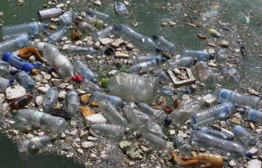
'Macroplastics' like these break down into microplastics, which are particularly harmful to marine life. Could satellites help detect macroplastics before they break down into tiny pieces? Satellites collect data on light signals, among other things. Materials can be distinguished using light signals based on which wavelengths of light they reflect. While clear water efficiently absorbs light in the near-infrared (NIR) to shortwave infrared (SWIR) light range, floating materials like plastic and natural debris reflect NIR instead. These differences in light absorption allow satellites to detect floating objects from space. The NIR signals of various floating objects vary. Using the satellite data, researchers trained a machine-learning algorithm to identify the light signal of floating plastic by releasing a plastic float off the coast of Greece and obtaining the associated light signal data from the satellites. The researched used this light data to teach the algorithm to associate certain NIR light signals with floating plastic debris. Similarly, they also taught the algorithm to distinguish between plastic and natural materials such as seaweed, driftwood, and seafoam.

The satellites re-visit every coastal area in the world every 2-5 days, collecting lots of data that could be used to track plastic pollution in the ocean. Once the algorithm was up-and-running, the researchers put it to the test against satellite data from coastal waters in four places around the world: Accra (Ghana), the San Juan Islands (Canada), Da Nanng (Vietnam) and Scotland (United Kingdom). Overall, the algorithm detected plastic with 86% accuracy. Better yet, the algorithm was 100% accurate in its analysis of the data from the San Juan Islands. Not too bad for data collected from thousands of miles above! Importantly, this algorithm is equipped to locate plastic pieces greater than 5 mm in size or larger with the satellite data provided. However, it is from these floating ‘macroplastics’ that many harmful microplastics form. These results show that satellite data combined with machine-learning algorithms could aid in the tracking, and subsequent clean-up, of plastic pollution around the world. This article has been published from a wire agency feed without modifications to the text. Only the headline has been changed. #Satellites#MachineLearning#Plastic#Ocean#oceanictask#plasticpollution#NIR#SWIR#naturaldebris#algorithm#satellitedata#macroplastics#microplastics#news#blockgeni Source link Read the full article
0 notes
Photo

Machine learning is making impossible things possible. Recent research (published in Nature Communications) by scientists at the Plymouth Marine Laboratory in the UK has found that satellite data could be analyzed using a machine-learning algorithm to detect plastic pollution in oceans. This would aid in the subsequent clean-up of plastic pollution.
#machinelearning #satellitedata #MI #MIalgorithms #plasticpollution #sourcesoft
0 notes
Text
Rail network downtime causes huge disruption Earth orbiting imagery helps to detect potential landslides & measures ground stability http://ow.ly/4wm130jVBEK #SatelliteData #Innovation pic.twitter.com/HceHZIm7AB
Rail network downtime causes huge disruption

Earth orbiting imagery helps to detect potential landslides & measures ground stability


http://ow.ly/4wm130jVBEK #SatelliteData #Innovation pic.twitter.com/HceHZIm7AB

source https://twitter.com/ESAbusinessapps/status/995636066395787264
View On WordPress
0 notes
Text
#telecom#defense#SatelliteData#SpaceTech#EarthObservation#TelecomInnovation#GeospatialIntelligence#SmartCities#SatelliteServices#MarketGrowth#Aerospace#FutureOfData#RemoteSensing#electronicsnews#technologynews
0 notes
Link
via Twitter https://twitter.com/PitchMaintain
0 notes
Photo

Buonanotte Cyprus 🛰️ my eyes are on you 😉#SpaceAppCamp 2019 #satellitedata #Space #satellite #Datavisualization #esrin #ESA #italy @europeanspaceagency @esa_earth @youresa (at European Space Agency ESA-ESRIN (Frascati)) https://www.instagram.com/p/B2nJBpxHFIA/?igshid=1twx312w6uh0t
0 notes
Text
#enabling faster#SatelliteData#DisasterRelief#TechForGood#EmergencyResponse#Innovation#electronicsnews#technologynews
0 notes
Photo

Tge first ever image extraction from ESA Copernicus satellite 🛰️⠀ #SpaceAppCamp 2019⠀ #satellitedata #Space #satellite #Datavisualization #esrin #ESA #italy @europeanspaceagency @esa_earth @youresa (at European Space Agency ESA-ESRIN (Frascati)) https://www.instagram.com/p/B2jjpyRptBz/?igshid=1olqnbqcn8udb
0 notes