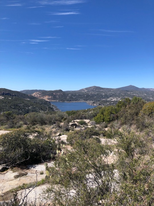
#Tehachapi mountains
Explore tagged Tumblr posts
Visit Tumblr Blog
Explore Tumblr blogs with no restrictions, modern design and the best experience.
Last Seen Tumblr Blogs


Fun Fact
Hackers stole 65M passwords from Tumblr in 2013.
Text


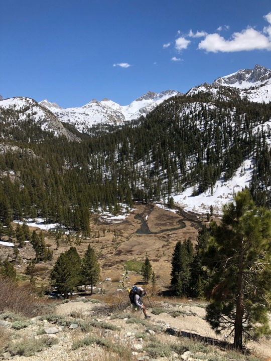
Isaac Hainley on Endurance: Tehachapi
For some reason, I was always charmed by Isaac on Endurance. While the first episode I've watched from this season was the second-to-last episode--the one after his Green Team got eliminated--his down-to-earth, chill personality really piqued me. And when I got to watch the whole season, his strengths came to life.
Thinking about it, Isaac was the leader of the main Purple-Green alliance of the season. He had a good head on his shoulders and had a friendly personality, but was also very loyal to his friends. This played a huge role in "Hang 5", in which he didn't want to harm either the Purple or Blue Teams, but would've put Jeszie's friend Erika on the chopping block.
This played out an interesting paradox with the Green Team. In missions, they were absolutely dominant, being the only team since E1 Blue (Aaron and Jonna) to win three missions in a row. In strategy, they diverged quite a bit in terms of whom to protect; after Gray was eliminated, Isaac was closer to Purple and Yellow, while Jeszie was closer with Red. They were also different personality wise, with Isaac being more chill and Jeszie being a firecracker. As mentioned before, they clashed, and their teamwork wasn't the same after Hang 5.
But at the end of the day, if I could have any partner, I would most definitely have Isaac. He definitely had the athletic abilities to do well in missions, thanks to participating in multiple sports when he was in high school. He sticks with his allies and tries hard not to rock the boat, and could work with a lot of people, and I find all of them valuable traits to succeed on Endurance.
(And on a side note, seeing Green getting eliminated near the end hit harder on a rewatch. The final eliminations on the seasons before and after were obviously heart wrenching, but this one hits because you've seen Isaac and Jeszie do so well, and then even they could not escape fate.)
#endurance#endurancedk#discovery kids#endurance tehachapi#endurance 4#isaac hainley#green team#realitv tv#reality television#throwback#tehachapi mountains#i have a huge soft spot for him#could i claim to be from portland instead?#because the only endurance contestant from seattle is...yeah
2 notes
·
View notes
Text
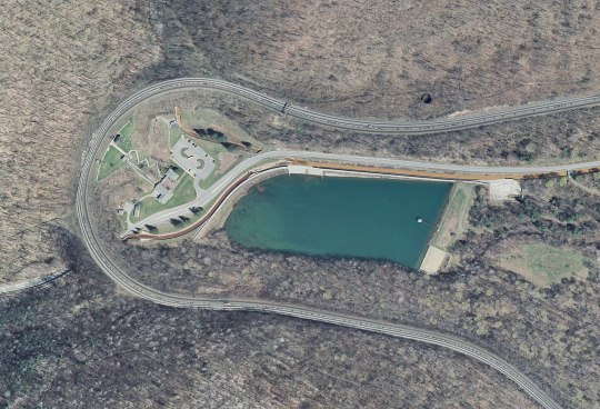
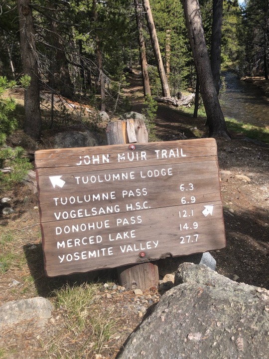
A Lot Going on Here

t's a cloudy April 17, 1971, a busy day on Tehachapi. SP 3207 is leading the northbound SAN JOAQUIN DAYLIGHT around the iconic loop at Walong, California. The Santa Fe units are off a southbound train left at Woodford, the next siding north. The AT&SF locomotives helped push a stalled northbound SP freight into the Walong siding to clear up for the DAYLIGHT. (You can spot the top of the SP caboose behind the four units.) As soon as the DAYLIGHT clears, the Santa Fe units will follow and couple to their train at Woodford.

It was a cloudy day, but because of all the action, it was one of my best trips to that popular piece of mountain railroading
(Joe McMillan on Flickr)
34 notes
·
View notes
Video

flickr
Tale of an F45 por James Belmont Por Flickr: Doug Harrop Photography • April 8, 1977 A Santa Fe Railway F45 leads a five pack of six axle EMDs through 259 ft. Tunnel 17 in the Tehachapi Mountains west of Cable, California. Santa Fe 5910 has quite an interesting story to tell. It began its service life as ATSF 1910, built by EMD in June 1968. It would later be renumbered ATSF 5910, later 5960, and by 1985 it received a fresh coat of SPSF livery, for a proposed merger that never happened. After retirement, 5960 was sold to Morrison Knudsen who renumbered it MKCX 5531, joining the lease fleet. By May 1995 it was leased to the Utah Railway, becoming UTAH 9013 and assigned to haul coal across Soldier Summit. After the lease ran out in 2001, it was shipped to Metro East Industries in East St. Louis, Illinois and was placed in storage, where it remained until at least 2007. By 2009, it arrived in Essex, Montana. The prime mover had been removed, and the body and cab interior became a luxury hotel. It was renumbered to GN 441 and repainted in Great Northern's attractive "Sky Blue" livery where it stands today.
13 notes
·
View notes
Text


Just discovered! Nick is a ranch hand and musician in the Tehachapi mountains in California; he told me he dips Cope snuff and smokes reds
Follow JustDippers for new dippers every day
15 notes
·
View notes
Text


Monsoonal Storm to the West
May 31, 2025
The Frazier Fire is out and not being restarted as of today. We are hoping for rain to ensure they can't start any more fires. We have a 30% chance of rain and thunderstorms overnight.
There was a severe thunderstorm this afternoon west of Lockwood Valley extending to the coast. The NWS issued a severe thunderstorm warning calling for half inch hail which could cause damage to cars.
We saw the edges of this system today, with electrified OR clouds to the west in the late afternoon and early evening. There is sporadic rain throughout the mountains from Tehachapi to Frazier Park as well as in the desert and Sierras this evening.


#orgone#orgone energy#orgonite#weather#forecast#thunderstorms#california#mountains#sierras#desert#monsoon#rain#clouds#sky#frazier park#frazier fire#geo-restoration
2 notes
·
View notes
Text
Flight impressions
11/16/1987. 4:04pm
We lifted off about 4 minutes ago. We soar above LA smog on flight 1895 bound from San Diego to Fresno with a stop in LA. We circle out over the Pacific. Tiny planes dart by far below. The earth hangs beneath all festooned in her riches of black, green and silver fox grey blue, like patterns in material art. It’s like watching an unreal movie. We bank. The mountains hang in their mist as if in magic—a blue sky trim harkens and harbors a peace lite halo. The feeling is above it all.
4:11pm. The land below coddles a lake, holds it in grip like a child in a mother’s lap.
4:14pm. I’ll try out the field glasses. Flight stewardess just passed by. Don’t think I want anything. Peanuts ok.
4:14:39. We pass over the Tehachapi’s into the great Central Valley. The mountains caress down into the valley in a peaceful, almost seductivly sensual, sexual way. They gently feel their way neath velvet bed spread of valley’s sleep. A bright sun enters from left. A beautiful blue luster shimmers beyond.
About 4 plane cashes in the last 24 hours. I imagine the thought flits through all 60 or so minds on board. I feel safe aloft.
4:18pm I’ll try out the field glasses. Nope, don’t seem to work too well up here.
4:22pm. A bit of turbulence!!
4:28pm. A bell chimes. We begin our diescent. I perceive a drag of the engines. Broad solid rock wall of the Sierra Nevadas to the East. White cotton clouds, blue grey mist of day adds majesty. The sun peaking in on the west.
The clouds and mist mimic the sea in their attachment to the land—they hug up and cuddle and out to sea, they swell and crest in repetition.
4:36pm. The cabin grows much darker. Fasten seat belt. We begin descent into Fresno. Here, below, we find a peace not present over LA or San Diego. The cities sit like computer chips midst a green checker board.
We are space people. We truly live on a revolving jewel. Emerald of the sky. The mountains vanish to mist.. Feeling of falling.We drop from higher realms of reality to a lower physical place. We are blinded now of strength of rock mother, but, she is there all the same. Now, the physical world reaches up to touch as time slows, speed slows, weight and velocity alter. Weighting down, down, down, down—flaps and wheels scream.
We give up freedom of the sky for security of the earth. But, they are at different speeds and places. We have seen. We shall not un see.
Pale grey, brown. Closer, closer, closer. Cars, highway, runway and—we land! 4:42:55pm
End of entry
Note: 3/24/2024
I had been in SanDiego for a criminal law class and to visit with my sister Zoe who lived there at that time.
I googled 4 plane crashes November 1987. The one that came up was flight 1713 that crashed on take off from Denver, Colorado’s Stapleton Airport on November 15,1987.. The pilots failed to properly de ice the wings and took off at too steep a pitch. Some on board died. The cause of the crash led to changes in aviation safety rules.
#11/16/1987#the feel of flight#the earth as the revolving jewel. Emerald of the sky#crash of flight 1713. 11/15/1987 Denver Stapleton Airport
10 notes
·
View notes
Text

This is the southernmost tip of the valley I grew up in, near the Tehachapis and the edge of the Mojave. This photo is from right north of the Grapevine (the mountain pass through the Tehachapis that connects LA metro area with the Central Valley).
It's really pretty down there in south Kern, but most of the Valley is honestly pretty sketchy. It's a lot of meth, churches, pesticides, and poverty. It was a double plus unfun place to be an LGBT kid and I'd be surprised if it's actually changed at all.
2 notes
·
View notes
Note
If you were making that list, what would you consider the seven wonders of the railroad world?
Hm, putting me on the spot here!
I mentioned Horseshoe Curve in Altoona, PA for a reason.
Horseshoe Curve was completed in 1854. The purpose of it was to reduce the grade trains had to climb up through the mountains and avoid the much more time-consuming route of the Allegheny Portage Railroad. Today, there's a visitor center in the middle of the Curve, and railfans go there to watch trains go by and picnic outside.
As mentioned in the previous post, Tehachapi Loop is also impressive and I'd give it a spot - it legitimately looks like something out of someone's model train layout.

From above this doesn't even look real. But it's real!
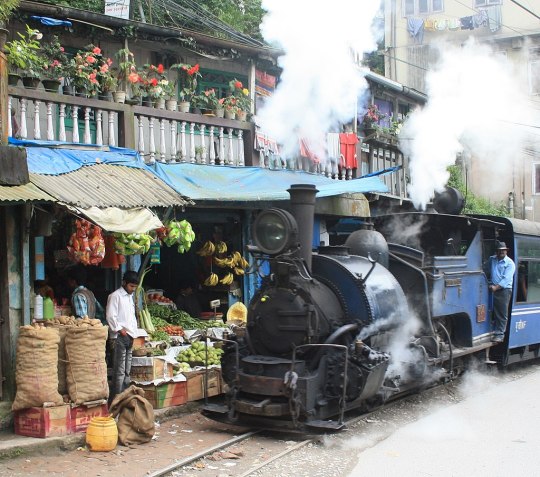
I've seen some people put the Darjeeling Himalayan Railway in West Bengal on their lists, and I'd agree with them. It's a UNESCO World Heritage Site for a reason. It's narrow gauge, climbs up through the mountains, and is popular with tourists - and although it has some diesels it also still uses steam. Look at how cute this locomotive is.
Another UNESCO World Heritage Site for consideration is the Forth Bridge, in Scotland:
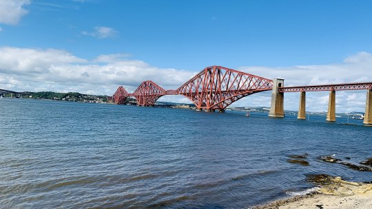
It's a cantilever railway bridge and was the longest cantilever bridge span in the world at the time of its opening, a title it held between 1890 and 1919. It's still the second longest today. In 2016 Scotland voted it as their greatest man-made wonder, an impressive feat in a country stereotyped as being chock full of civil and mechanical engineers.
For reaching incredible heights in the 19th century, look no further than the Ferrovías Central in Peru.
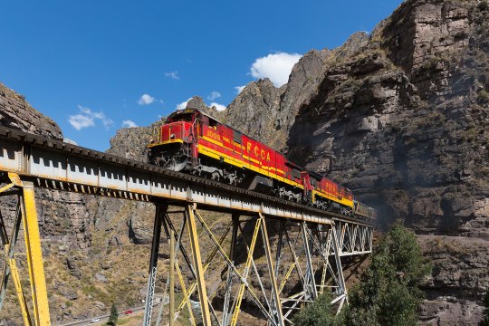
Designed by a Polish political exile named Ernest Malinowski, it was built in the 1870s and still operates today. What was known as the Callao, Lima & Oroya Railway at the time of its opening is still the second highest railroad in the world today, only being surpassed by the Qinghai-Tibet Railway over 100 years later.
It would be silly not to include the Trans-Siberian Railroad on this list - in terms of sheer scope, this thing is massive.

It's the longest railway line in the world. Nothing else even comes remotely close. Trips along it can take weeks depending on the speed the trains are running.
Lastly, for a more modern entry, I'd propose the Channel Tunnel linking England and France - at its lowest point, it's 246 feet below sea level. In terms of a modern feat of engineering, this one is definitely up there. It was completed the year I turned five, and it was a big deal even over here in the US.

Of course, the fun of this is coming up with your own! And I had to think pretty hard about this because I was trying to do it without using any locomotives, which would have been a cop-out!
Here are a few links to people having this debate online, in case you want to read more - 1, 2, 3, 4
23 notes
·
View notes
Text

Excerpt from this press release from the Center for Biological Diversity:
The Center for Biological Diversity submitted a petition to the U.S. Fish and Wildlife Service today seeking Endangered Species Act protection for California’s Mount Pinos sooty grouse. The species, known for hooting from treetops, has been driven out of most of its habitat in recent decades.
The grouse was historically found in high-elevation forests and meadows from the southern Sierra Nevada Mountains southward into the “sky island” mountains of Southern California, including the Tehachapi Mountains and Mount Pinos region of Ventura County. Today the species only survives in a dwindling portion of the Sierra Nevada.
“The lovely Mount Pinos sooty grouse could easily go extinct without immediate federal protection,” said Brian Segee, endangered species legal director at the Center. “These captivating birds have already disappeared from Southern California, including their namesake Mount Pinos, and without protection their remaining populations could be lost forever.”
Mount Pinos sooty grouse have declined due to logging, livestock grazing within meadows they need for brooding and raising their young, fire suppression resulting in elevated fire risk, and loss of high-elevation forest and meadow habitat due to climate change. Continued hunting of grouse within their remaining range poses an additional threat.
Unlike other North American species such as sage grouse that participate in communal courtship displays, male sooty grouse are strongly territorial. Individual male birds hoot from the tops of tall trees to attract females. Hooting sites are typically located in massive fir or pine trees and are returned to for generations.
4 notes
·
View notes
Text
Thoughts-We’re in Northern California NOW, Right?
It might seem like kind of a silly question, but I swear the answer is interesting. For anyone who doesn’t know, the PCT is divided into 5 major sections: Southern California, Central California, Northern California, Oregon, and Washington.
There’s no question about Oregon and Washington; Oregon starts when you leave California and ends when you get to Washington, which ends when you get to Canada. Southern California starts at the Mexican border, and Northern California ends at the Oregon border. But what about Central California? Where does it start and end? There’s no consensus. You would think there would be some official source on this, but there isn’t.
Opinion 1: FarOut
FarOut is a digital map, it uses GPS. Very useful for navigation. Basically every through hiker uses it, it’s like our bible. It says that Central California starts in Tehachapi (Mile 550) and ends in South Lake Tahoe (Mile 1090). From a “Vibes” standpoint, this makes sense. You feel like you’re out of the desert when you get to Tehachapi, and you feel like you’re out of the mountains when you get to South Lake Tahoe.

Opinion #2: Geography
You might argue that Central California is defined by the Sierra Nevada Mountains, and so it should start and end with the Sierras. In that case, it would go from Ridgecrest (Mile 650) to Belden (Mile 1290). This is a sort of a “erm actually 🤓” answer to the question. I don’t think many hikers really care about where the mountain range technically starts and ends: they care about trail conditions.
Opinion #3: The Pacific Crest Trail Association
The PCTA is the body that issues permits, coordinates trail maintenance, and puts out the latest information about trail closures. They define Central California as going from Kennedy Meadows South (Mile 700) to Truckee (Mile 1150). The point of view on this is kinda similar to FarOut. You’re not really in the mountains until you get to Kennedy Meadows, and you’re not really out of the mountains until you get to Truckee.

Opinion #4: The PCT data book
This is an unofficial guidebook, but it’s been going since like the 90s. They update it every few years, you get the idea. It says that central California goes from Kennedy Meadows (Mile 700) to Belden (Mile 1290). I don’t really get this? They might be basing it mostly off geography and a little bit off hiker needs and common sense.
Opinion #5: Hikers
We’re not a hive mind, obviously, but I have heard some common opinions. Pretty much everyone seems to regard Kennedy Meadows South (Mile 700) as the start of the Sierras. Some people view South Lake Tahoe (Mile 1090) as the end. One opinion that I heard a lot that wasn’t mentioned by any official source was that Kennedy Meadows North (Mile 1020) is the end. This is probably because that’s the first place where you can reasonably send your bear can home, which is a big deal for hikers.

Opinion #6: What do I think?
I agree with the PCTA. It’s personal for me: there was still plenty of snow up to that point, and I didn’t get rid of my bear can until then either. I didn’t want to have to rush through the desolation wilderness. Plus, there are some new restrictions in place. A bear can is gonna be required for more of the trail next year, so I think Truckee is gonna be the new spot to ditch your bear can.
Okay, I’m going to bed. Good night. 🌙
5 notes
·
View notes
Text

Where the elk and the muleys roam
While in California around the start of the new year, Sharon and I were out for a stroll in the Tehachapi Mountains with our daughter-in-law's parents - Chris and Satsuki - when we met this handsome mule deer and his harem.
The area we hiked is not particularly remote and yet deer, elk and an occasional bear wander through the subdivision as freely as the human residents.
In fact, Satsuki's wildlife photos, taken from her back door, played a roll in convincing me to get a real camera.
For this shot, I had only my cell phone camera.
9 notes
·
View notes
Text
I realized that I need to be more active on “the TUMBLR®️”!
Thanks to all the follows and follow-backs and little hearts ❤️
And many more
#photography#germany#ulm#fotografie#ulmfotograf#original photographers#nature#trees#iphonography#travel#follow back#thanks
6 notes
·
View notes
Text
soaringly heartsick for LA county nature - the steep mountains and high cliffs of the San Gabriels, the mountain streams, the desert just an hour away, the alpine forests and breaktaking ridges and zones of elevation which divide the hillsides into seasons which winter descends down and spring climbs up in waves, the rushing waterfalls and bare expanses and secluded canyons - and the speciation and diversity of ecologies that wraps its fingers into the granite where even the north side of a ridge can have wildly different climate from the south. the brutality of the environment which sweeps from the Mojave over the peaks and nearly down to the valley produces so much beauty that goes more or less untrampled by industry or pasture. the San Gabriels reclaim, often, what man thinks right to build - Tongva paths survive but roads and buildings do not. I want to feel the air grow thin at 8,000 feet and I want to be fast on my bike on washed-out roads with no cars. if I'm going to be alone today I want it to be Alone. I want it to be wrapped in the embrace of the canyon walls with nothing but hawks and ravens for company or out on the bajadas of the Mojave with the Tehachapis snowsoaked and the buckwheats flowering along seasonal streams. I want the isolation to make sense and I want to come home sunscoured and windchapped and tired as hell. let it sting a little. I want to feel it all.
#getting weird in my brain a little about things#what can i say i wanna get my ass kicked and i want it to be beautiful
4 notes
·
View notes
Text
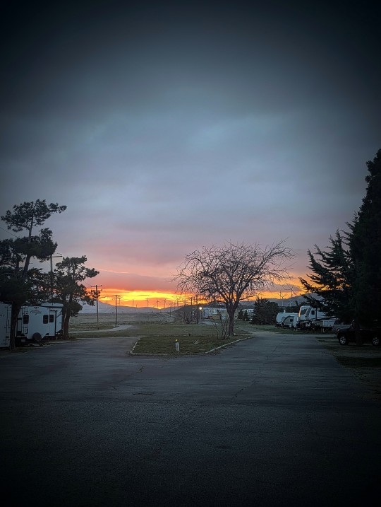
Another Issue....A Change of Plans - Tehachapi, CA
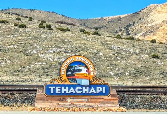
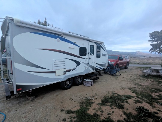
I forgot to mention something that happened during our travels yesterday - our fresh water tank release valve was jiggling loose and we were losing water. We thought we had it figured out, but whenever we pulled over we were still losing water. So, we changed our plan to dry camp at the truck stop in Tehachapi and booked into an RV park, where we could fill our fresh water tank and figure out what was happening with the release valve. Doug tied some rope around the release valve pull so that it couldn't move, hopefully, that will fix it.
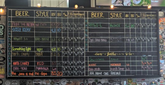
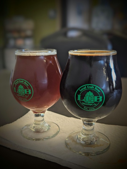
Once that was handled, we headed into town to check out a local brewery. The name of the brewery was Local Craft Brewery or LCB. We enjoyed the beer and the local flavor:
The evening and the temperatures were pleasant - Tehachapi is up in the hills, so things were a bit cooler. Still a great stay in this lovely little town. We stayed at Mountain Valley RV Park, which is attached to the local airport. Fortunately, the planes were few and far between during the time we were there. Nice small park, we would definitely stay here again.
0 notes
Text
Winter weather advisory issued for Los Angeles County for Saturday and Sunday – could see 7 inches of snow
5 Freeway through Grapevine, South End of the Upper Sierra, Piute Walker Basin, Tehachapi and Frazier Mountain Communities were placed under a winter weather advisory by the National Weather Service on Friday at 11:51 a.m. The advisory is valid from Saturday 5 a.m. until Sunday, Apr. 27 at 11 a.m. The NWS Hanford CA adds to be ready for, “Total snow accumulations up to 7 inches. Winds gusting as…
0 notes
Text
Seen in passing
Sacramento International Airport Terminal A from the parking garage Just a few of the sights from our recent travels to and from Texas this year. Jenny the burro waiting for a snack — Ludlow, California Twin Arrows, Arizona, a ghost town along Route 66/Interstate 40 Classic 1968 Dodge Dart heading east on a car carrier East of Holbrook, Arizona Tehachapi Mountains in green, April 2025 Terminal A,…

View On WordPress
0 notes