#garmin-map
Explore tagged Tumblr posts
Visit Tumblr Blog
Explore Tumblr blogs with no restrictions, modern design and the best experience.
Last Seen Tumblr Blogs


Fun Fact
Tumblr has a low social media market share in South America.
Text
Printer Setup and Installation: A Complete Guide
Are you thinking how to set up a printer, here is the simple guide you can follow the instructions and you will be able to set or install.

#GPS Update#GPS map update#GPS update services#how to update GPS#Latest GPS Maps update services#gps update services in US#how to update GPS devices#garmin map update#garmin map update free#latest garmin map update#Latest GPS & Maps update services#garmin how to update#garmin gps update#upgrade garmin gps#how to update garmin gps
0 notes
Text
.
#sometimes I wish there was a way to stop having a smartphone while still having the maps ability#saying this quiet (in the tags) because I don’t want anyone to come telling me about regular paper maps or like#looking up directions Mapquest style. I already know about those#that’s not what I want. I want the gps and being able to search for places in it but I don’t want it to spy on me that’s all#that’s all I want. like an everyday walking garmin I guess#y’all remember garmin? when we cracked that technology?#my mom had one. I remember once we were driving in rural Wisconsin late at night and for some reason it kept mispronouncing ‘#‘county road’ in an incomprehensible manner. we laughed about it a lot.#anyway. truly the goal is just to not get spied on#would be nice#and devices with specific purposes I think#idk man the years of not being on the internet every day are long behind me and I’m really starting to miss them#remember summer camp? we weren’t allowed to have phones or electronics at my summer camp.#I would sneak in my iPod nano to listen to podcasts and help me fall asleep when I got older#(wow I haven’t changed since 13 I guess)#but like a whole day with no internet no devices! just getting dirty and sweaty and playing games and hiking and swimming#I YEARN for if y’all. truly. and also. if anyone tells me I can just put my phone away or whatever I know you’re technically right but#I simply don’t care because that’s not. the point.#I’m rambling. anyway.#my post
1 note
·
View note
Text
What Maps Come With Garmin 67i?
Have you ever wondered what maps come with the Garmin 67i? If you’re considering this GPS device for your outdoor adventures, you’re in the right place. Navigating the world of GPS devices and their features can be a bit overwhelming, but we’re here to make it easier for you. By the end of this article, you’ll know exactly what maps to expect with the Garmin 67i and how they can enhance your…
0 notes
Text
How to Set Up Garmin Express?
Setting up Garmin Express is a straightforward process that involves a few steps. Garmin Express is a software application that allows you to manage and update your Garmin devices. Here's a general guide on how to set up Garmin Express:

Download Garmin Express:
Visit the official Garmin Express website (https://www.garmin.com/express) using your web browser.
Click on the "Download for Windows" or "Download for Mac" button, depending on your operating system.
Install Garmin Express:
Once the download is complete, open the installer file.
Follow the on-screen instructions to install Garmin Express on your computer.
Connect Garmin Device:
Use a compatible USB cable to connect your Garmin device (such as a GPS watch or navigation device) to your computer.
Turn on your Garmin device.
Open Garmin Express:
Launch the Garmin Express application on your computer.
Set Up Garmin Account:
If you already have a Garmin account, log in using your credentials. If not, you will need to create a new account.
Follow the prompts to enter your email address, create a password, and provide other necessary information to create your account.
Add Your Device:
Garmin Express should automatically detect your connected Garmin device. If not, click on the "Add a Device" option and follow the on-screen instructions to add your device manually.
Device Registration:
Register your Garmin device with your Garmin account. This step is essential for receiving product updates and support.
Software and Map Updates:
Once your device is added, Garmin Express will check for software and map updates. Follow the prompts to install any available updates.
Sync and Configure:
Explore the options within Garmin Express to customize settings, sync data, and manage your device.
Eject Your Device:
After completing the setup and any updates, safely eject your Garmin device from your computer.
That's it! Your Garmin device should now be set up and ready to use with Garmin.com/Express. Remember to periodically check for updates to ensure your device has the latest features and maps.
0 notes
Text
Growing up Gay in the Age of Google Maps, Grindr and ChatGPT
From the time I knew what intersections were, I said my family lived at the crossing of Inwood Road and Preston Road in North Dallas. I asserted that fact certainly for the better part of a decade. Then I found out those two roads ran parallel to each other. Then we moved to a different house. I did eventually learn our new home’s location and nearest intersection. I did not, however, pass my…

View On WordPress
#Abby#chatgpt#Dungeons & Dragons#Elon Musk#Exley#Fran Drescher#Garmin#garmin gps#Gay men#Geosocial networking#Gizmodo#Google#Google Maps#Greggor Mattson#Grimes#Grindr#Joel Simkhai#Matt Shumer#OBERLIN COLLEGE#SAG-AFTRA
1 note
·
View note
Text

Many of the roads I bike and trails I hike don't have cell service, so a few years ago Beth got me this Garmin GPS Map 66i. It has a ton of a features including satellite messaging, weather, maps etc. In the intervening years the iPhone has introduced satellite SOS calling and I could use that if necessary, but the Garmin lets me send Beth a map link which updates every 10 minutes.
I've carried it hundreds of miles and it has accumulated some wear but dropping it in the garage cracked the screen. I chatted with Garmin support and they said it wasn't repairable and even though it is a few years old they offered a good discount on a refurbished unit.
The refurbished unit looks brand new. It takes a while to get it setup - hard to believe but downloading the maps takes 3.5 hours, even when syncing from my laptop.

36 notes
·
View notes
Note
could you do a hunting gear haul of all the stuff you use for the dogs, like the reflective vests that you use and collars and such. I don't know what reflective vest I should buy for my dog and am wondering what a hunter uses.
The vests are old Ruffwear Track Jackets, they are not made anymore but you can still find them in ruffwear resale groups on facebook and sites like ebay. The newer version Ruffwear has is more bulky. A lot of hunters use vests made by a guy called Larry Riel, he does stuff the old fashioned way, you gotta call him and send a check.
The collars I have are 1.5" reflective biothane with name plates riveted on. I do not use dangly tags when hunting, they just get ripped off. I buy most of my hunting dog collars from Outdoor Dog Supply and Double U Supply.
You can use whatever leash, always have one with you.
My dogs also wear Garmin Alpha GPS collars. I have the Alpha 100 and TT15Mini collars. I like being able to use the tone when my dogs are out of sight or hearing for recall. If you want a Garmin GPS but don't want ecollar functions (which are customizable) you could get an Astro instead. I have birdseye, property types, terrain, trails, and road maps installed on my handheld. Be very careful buying these used, don't get them from some random guy on facebook as most of the time that is a scam. Buy from a Garmin authorized reseller for used and refurbished units. Most of them run black friday deals on Alpha and Astro units and collars.
GPS is not necessary to hunt with, I just strongly prefer to have it because I hunt on small tracts of land and like to know exactly where my dogs are.
You can use a cheap blaze orange shirt, hoodie, hat, or vest from walmart and as long as you've got the minimum required amount of blaze for your state you'll be good. You can carry squirrels in any kind of bag or pack, you do not need specialized equipment for that but it does make it easier.
The first vest I used was a Browning Upland vest I got for cheap on sale somewhere online. It's got pockets for carrying shells and game, but did not have a waist belt, was kinda bulky, and got warm quickly. This is a very common style of vest and you can find them for much cheaper than this one is new.
The vest I use currently is an older Orvis Pro Upland vest. I got this on sale too, I almost never pay full price for hunting stuff. They have a couple other models, and lots of other companies make these too. The problem I have with mine (and a few others I've tried) is they are too big even in the small size, and getting a vest that actually fits me from a company that makes products for smaller people and women is ridiculously expensive, so I just deal with it.
Most of my smaller hunting gear fits in this vest. Binoculars, leash, spare battery for the GPS, a headlamp, water bottle, multi-tool, snacks, and ammunition.
Boots, boots are very important. Wear something comfortable that is built for the terrain you'll be hunting in. During the earlier season or if it's not too cold and there's not a lot of water or snow, I wear my Merrell Moab hiking boots. I occasionally wear a pair of gaiters if I'm hunting a really brushy area, but only with the hiking boots. Once it's cold, snowy, or really wet, I wear muck boots, usually my Arctic Pros.
My favorite brand of socks are Darn Tough, I wear those for everything. They are worth what you pay for them and have a lifetime guarantee.
If you have to wear gloves, be sure you get something with good grip. A warm pair of gloves is useless if you can't hold anything. Since my shotgun is a pump I really need good grippy gloves to cycle a new round. I often just wear my mountain biking gloves from HandUp.
Since I hunt brushy and thorny areas, I wear brush pants. I have a fancy-ass pair from First Lite that are *extremely* comfortable, but they do not go over my mucks and are not good for very cold temperatures without a base layer or two. They are great for warm season hunting though. I recently got a pair of Duluth briar pants and they are my new favorite, but I cant find them on the website at the moment.
Brush pants are another very common item that you can get cheaply from other makers and are frequently on sale. You can also just use a thick pair of work pants, I hunted in double front carhartts for a couple years. Chaps are another option.
I use a Remington 870 Wingmaster 12 gauge fixed modified pump action shotgun and steel #6 small game shot. (A lot of words, I know.) You can use many different firearms, and some states allow you to use air rifles too. A friend I hunt with is a big fan of his Benjamin Marauder. I've seen people use slingshots, archery, and even hawks. Check your regulations to see what is legal and pick something you are comfortable with.
I accumulated my gear over time and either inherited it, bought used, or on sale. I've been hunting for 10 years now, when I first started all I had was my hiking stuff, shotgun, and a blaze hat. Hunting is only complicated and expensive if you make it.
20 notes
·
View notes
Text
to my word now i'll be true
@cycleprompttuesday: "read"
also on ao3.
it should, maybe, be a bit concerning, your inability to say no to him.
attack with me tomorrow, he jokes, as you both catch your breath on the rollers, side by side like always. it’s a mountain stage tomorrow, the last of the tour. there are dark circles under his eye that match yours, but he’s smiling, just a little - and this is the moment, you will think later, when you doomed yourself. you would do anything, for that smile, even push yourself up a mountain on a stage that no longer means anything for you.
come to my hotel tonight, he asks, one hand wrapped around your wrist and his thumb brushing against your pulse point. he’s pulled you aside, behind the podium, with pollen on the shoulder of his jersey, a flush in his cheeks, and the roaring of the crowd still ringing in your ears. it is no small thing, what tadej's asking of you. it’s no small thing, the answer you will give him. his eyes are big and blue and beautiful, and you are helpless.
don't leave yet, he murmurs into your skin, after your heart rate has returned to normal and his hands have mapped what feels like every square centimeter of your body. your phone beeps insistently, where you flung your bag in the corner earlier, in your impatience. tadej's face is tucked into your shoulder and his lips mouth lazily along the line of your neck. it feels nice, you can admit that to yourself. you want it, and his lips are very insistent.
visit me in monaco, he urges, his voice slightly distorted through the phone speaker and his face pixelated, just a little, through the terrible hotel wifi. it’s not a question, this time. tadej's gotten more confident, more sure of what this is between you. there’s no need to look at your calendar to know you’re booked the entire week he suggests. you think of salty air and french mountains and your hands in his hair. there’s no need to hesitate before you agree anyway.
come to bed, he whines from where he’s huddled under multiple blankets and a mountain of pillows. you turn another page - only four more before the end. shuffling, the rustle of sheets, arms around your neck. three more pages. before him you didn’t understand how good it could sound, your name whispered in your ear. two more pages. hercule poirot is revealing how he solved the murder, and tadej is revealing just how determined he can be. one more page. his tongue brushes the side of your neck. the book slams shut.
race with me, he calls, before he’s flying away from you up another mountain. he says it’s his favorite, but it’s also the fourth time he’s said that this week. he turns back to you, question and challenge and hope all rolled into one. you look at your garmin, where your carefully calculated numbers look balefully back at you, giving neither judgment nor encouragement. none is needed. the burning in your legs is nothing to the sound of his laughter when you catch him.
read to me, he pleads, fisting a hand in your tshirt but not looking at you. it’s been a bad day, you’ve known that much since he turned up on your doorstep with no warning. you haven’t asked any more questions. he will tell you when he’s ready. the book on your nightstand is a mystery, one you’re nearly finished with, but tadej will complain, tomorrow, if you don’t start it from the beginning. his breath is warm on your neck, and he is asleep before the first chapter is over.
let me see you, he begs, over text and phone and video call. it’s almost a surprise to you, that he has not yet booked a flight and turned up unexpectedly. you know tadej's schedule almost as well as your own, and you know he does not have the time. you know he’ll make the time. he’s crying, on the phone and over the video call, and surely uae can spare him for a day or two. you don’t want to be coddled, but it would be nice, to see him.
stay with me, he says, so quietly you almost don't hear it over the rush of the waterfall. his hand is tight in yours and his eyes are bright and he's looking at you like you're something wondrous to behold. you don't point out that he's the one who drove here, so you couldn't leave even if you wanted to. you don't remind him that you have a flight back to switzerland in three days. that's not really what tadej is asking. you don't have the words for him, but he doesn't seem to need them. the way you kiss him is answer enough.
it should, maybe, be a bit concerning, your inability to say no to him. you don't care anymore.
#did i write another second person tadejonas ficlet for the weekly prompt? yes. yes i did.#what if i wrote something
16 notes
·
View notes
Text
Stay on Track with the Latest Garmin Map Update
Ensure accurate navigation with the latest Garmin map update. Get real-time routes, updated POIs, and improved road data. Whether you’re driving or hiking, Garmin’s updates keep your journey smooth and reliable. Download now and explore confidently with the most recent Garmin GPS maps.

Latest Garmin Map Update
#GPS Update#GPS map update#GPS update services#how to update GPS#Latest GPS Maps update services#gps update services in US#how to update GPS devices#garmin map update#garmin map update free#latest garmin map update#Latest GPS & Maps update services#garmin how to update#garmin gps update#upgrade garmin gps#how to update garmin gps
0 notes
Text
Real-time Tracking!
While I'm hiking, I plan to share my location every ten minutes using my Garmin Messenger

My recent locations can be viewed on a map here: https://share.garmin.com/RobPCT2025
There are three check-in messages that I can post to the map:
"I'm starting my trip." I'll post this when I'm leaving camp in the morning or when I'm getting back on trail after being away (to obtain more food, for example).
"I'm checking in. Everything is okay." I'll post this when I'm taking a mid-day break.
"I'm ending my trip." I'll post this when I'm done hiking for the day or if I'm leaving trail for a while.
3 notes
·
View notes
Text
Does The Garmin 67i Come With Maps?
Does the Garmin 67i Come With Maps? Have you been eyeing the Garmin 67i and wondering if it includes maps? You’re not alone. Many people considering investing in this highly lauded GPS device are curious about what it comes pre-loaded with. Let’s get into the details and find out everything you need to know about the Garmin 67i and its mapping capabilities. What Is the Garmin 67i? Before we get…
0 notes
Text
Good morning. 🌻🌻🌻
26 April 2025

Do you remember traveling with a paper map in hand? It feels like such a relic of the 20th century now. I still have a stack of those tucked away in a cabinet above my desk—just in case I ever need them again. Do gas stations along the road even sell those anymore? Back then, you had to study the map carefully before starting a trip and pull it out at every stop to stay on track. It wasn’t too challenging, but missing a turn could cause real headaches. Nowadays, cars come equipped with built-in navigation systems that guide you seamlessly from start to finish. And if your car doesn’t have one, your phone can easily step in and do the job. Oh, and let’s not forget my old Garmin GPS—it's been collecting dust on top of my desk cabinet for years now.
"Maps encourage boldness. They’re like cryptic love letters. They make anything seem possible." – Rebecca Solnit
4 notes
·
View notes
Text
Māris ir 'gadžetu' cilvēks, viņam ļoti patìk visādas ierīces. Te reālajā laikā varēs redzēt mūsu atraŝanās vietu :)
2 notes
·
View notes
Text
What to Do If You Get Lost in the Wild
Even in the age of smartphones and GPS, stories of hikers getting lost in the wilderness still regularly appear in the news. How do people get lost even when carrying their devices, and what should you do if you ever find yourself in that situation? To answer those questions, I called up Creek Stewart, a wilderness survival expert and instructor and a longtime friend of AoM. Creek is the author of numerous books on wilderness survival and has been the host of several Weather Channel shows on the subject, including S.O.S.: How to Survive. Besides his over two decades of survival experience, Creek told me that hosting S.O.S. gave him a unique perspective on how people get lost in the wilderness and what separates those who survive and get rescued quickly from those who flounder. When he hosted the show, he interviewed dozens of folks who had gotten lost in the wild, often in popular national parks filled with other people. Below Creek shares his insights on how anyone can become disoriented when traversing the great outdoors and, more importantly, how to stay safe if it happens to you. Pre-Trip Preparation: How to Ensure Your Quick Rescue in the Event You Get Lost Creek says there are three things you can do before your trip that, should you manage to get lost during it, will dramatically increase your chances of a quick rescue and a safe return: 1. Tell people where you’re going and when to expect you back. Do this even if you’re going on a simple day hike near your home. 2. Ensure your phone is fully charged and bring a power bank. If you plan on using a digital app/map to guide your hike, you’ll of course want to make sure your phone is fully charged and has a backup power source as well. A phone is of no use if it doesn’t have power. People get lost, their phones die, and they can’t figure out where they are and how to get back on track. A dead phone not only contributes to getting lost, but prevents a quick rescue as well. Creek told me the one thing that all the people who had a slow rescue had in common was that they went out into the wild without a fully charged phone and without a way to power it back up. “The people who got found quickly typically had a fully charged phone, so when they got lost, they could make a call or at least put out a distress signal with GPS,” he told me. If you’re looking for a power bank for outdoor excursions, I like and use the S.A.B.A.N.I. Portable Charger 35000mAh Power Bank. You can charge your iPhone up to five times with this power bank. 3. Consider carrying a Personal Locator Beacon (PLB). Creek recommends buying a PLB or satellite communicator. While they’re pricey and require a subscription, they will allow you to send a distress signal and share your GPS location even when you don’t have cell service. Garmin makes two satellite communicators: * Garmin inReach Messenger Handheld Satellite Communicator. This device is also a Personal Locator Beacon, and it works with your smartphone, so you can text even when you don’t have cell service. * Garmin inReach Mini 2. It allows you to text and also has maps and weather forecasts. It’s more expensive than the original inReach due to those additional features. Doing those three things before you leave for your trip will ensure you get found within 24 hours of getting lost in the wild. In addition to doing those three things, Creek also recommends that you dress appropriately for the climate and bring some essential gear for any wilderness outing, even a short day hike. Pack the essentials we list here. Having those things on you in the event you get lost will help you stay safe and comfortable in the outdoors while you’re waiting to be found. The Psychology of Getting Lost If you stay on marked trails when you’re out in nature, your risk of getting lost is very low. Before you begin a hike, download an offline map on your phone in case you don’t have cell service. Again, make sure you have a power charger. And carry a paper map as a backup, too. According to… http://dlvr.it/TCRdLG
4 notes
·
View notes
Text

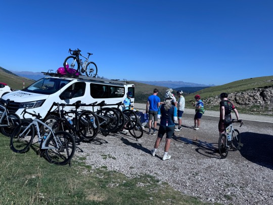


Day 8: Pulgcerda to Vic Sau
87.4 miles, 6:36, 7,454' ascent
The morning air was crisp as the riders reluctantly departed the nicest hotel of the trip, most wore light jackets which they stowed at the start of the climb after leaving the city.
As we approached the first climb we could see clouds near the top and knew we'd be among them before too long.
The first climb was > 10 miles long but it wasn't too steep so we reached the summit relatively quickly. While stopping at the van to refuel we donned jackets for the speedy descent through the clouds.
Because today's ride is so long, the scale of the elevation map is compressed so tens of small climbs aren't discernible, but trust me they are there. Although the ride after the initial climb was a net descent, all the little climbs collectively exceeded the ascent of the first big climb.
The weather was quite warm, especially after lunch. My Garmin hit 122f, but I think that's because it was sitting in the sun.
The route required us to climb the last 10k to the hotel, but we were rewarded with a good property with working AC and WiFi. All the riders are anxious to see the ocean tomorrow.
39 notes
·
View notes
Text
October and November can be challenging months for hiking in the Cascade Mountains.
With such a great range of elevation, you can be walking in fog near sea level, rain only 2,000 feet above sea level, snow above 5,000 feet above sea level, and then if you climbed higher you might even get above the clouds into bright sunshine.

In the national parks, like Mount Rainier, Olympic and North Cascades, you might drive in the park’s entrance in a pleasantly cool temperature but find it freezing at your trailhead. Besides being prepared with clothing and insulation, this also means that snow might cover your trail.
Except for the Pacific Crest Trail, no trails in Mount Rainier National Park are marked on trees. It is only the beaten path for guidance. Or is there more?

If you have a GPS device (global positioning system), such as a Garmin or other brand, you could load up the trail data ahead of time and have the device guide you when the trail is blanketed by snow. Battery power, especially in cold temperatures, can be key to keeping these working in order to get back to your motor vehicle.
Another option would be a paper map and a compass, if you have learned and trained on how to use those to orienteer across the landscape. These can be especially nice since they don’t require batteries or cell towers.

Some folks decide to use apps on their cell phones. Those can be handy and easy to use but you have to make sure the app you chose doesn’t rely on cell towers being within reach. There are many places in the park that have no service. Like the GPS device, these also need plenty of battery power and might lose their charge fast in cold weather.
What do you prefer to use when you go out for a snowy adventure in the national park?
Are you a person with a device and back-up batteries? Do you prefer paper maps and compass?
Or how about device and paper map and a compass? Having and knowing how to use all 3 isn’t a bad thing. ~ams
For more on the 10 Essentials, this website can help https://www.nps.gov/articles/10essentials.htm To find links for Mount Rainier specific weather forecasts try this website https://www.nps.gov/mora/planyourvisit/weather.htm
NPS Image. Mount Rainier National Park map from 1931. NPS Photo. Image from Mount Rainier National Park Air Quality webcam March 11, 2020. https://www.nps.gov/subjects/air/webcams.htm?site=mora NPS/S. Redman Photo. Fall colors of yellow and red on subalpine meadow in Paradise. Snow on evergreens in background. October, 2009.
19 notes
·
View notes