#gisbox
Explore tagged Tumblr posts
Visit Tumblr Blog
Explore Tumblr blogs with no restrictions, modern design and the best experience.
Last Seen Tumblr Blogs


Fun Fact
The “We are the 99%” Tumblr blog became the slogan for the Occupy Wall Street movement.
Text
Top 5 GIS Toolboxes: Unlocking the Full Potential of Geographic Information Systems
Geographic Information Systems (GIS) have become indispensable in urban planning, environmental protection, engineering, and other fields. With advancements in technology, various GIS toolboxes have emerged, helping users achieve more efficient data processing and 3D visualization. This article introduces five top GIS toolboxes to help you choose the best solution for your needs.
1. GISBox
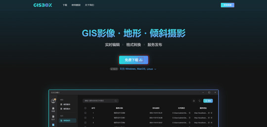
GISBox is a comprehensive GIS toolbox that integrates data processing, spatial analysis, and 3D visualization functions. A standout feature of GISBox is its efficient real-time editing capabilities, such as photogrammetric mesh repairs, riverbed depressions, and terrain alignment, which significantly simplify complex 3D terrain data processing workflows. Additionally, GISBox supports various mainstream publishing protocols, including 3DTiles, Terrain, and WMTS, offering a range of options for different users. Whether for small to medium-sized enterprises or individual projects, GISBox provides an all-in-one solution to efficiently handle GIS data processing and publishing tasks.
Pros:
· Supports multiple data formats.
· User-friendly plugin system for easy extension.
· Powerful 3D visualization and data processing capabilities.
2. QGIS (Quantum GIS)
QGIS is an open-source and highly customizable GIS tool widely popular among users globally. Its rich plugin ecosystem caters to various GIS needs, from basic map creation to complex spatial analysis.
Pros:
· Free and open-source, with an active user and developer community.
· Rich in plugins with strong extensibility.
· Highly customizable interface and workflow.
3. ArcGIS
Developed by Esri, ArcGIS is a professional GIS platform with a toolbox that provides hundreds of tools for geographic data analysis and map creation. It integrates data collection, processing, analysis, and visualization, making it the top choice for solving complex geographic problems.
Pros:
· Extensive data processing and analysis tools.
· Integration with other Esri products for a complete GIS workflow.
· Professional technical support and learning resources.
4. Global Mapper
Global Mapper is a comprehensive GIS software that supports a wide range of geographic data formats and powerful data processing functions. Known for its simplicity and affordability, it is suitable for users looking to quickly perform spatial analysis and data visualization.
Pros:
· Supports multiple data formats with robust data conversion capabilities.
· Gentle learning curve for easy onboarding.
· Comprehensive functionality suitable for projects of various scales.
5. SuperMap iDesktop

SuperMap iDesktop is a powerful GIS desktop tool that provides a full suite of tools for spatial analysis, data management, and 3D visualization. It is widely used in industries like urban planning, environmental monitoring, and infrastructure management. SuperMap iDesktop integrates a variety of data formats and supports a range of powerful GIS functions, including advanced 3D terrain modeling, geospatial analysis, and the ability to handle large datasets with ease.
Pros:
Advanced 3D modeling capabilities for creating and analyzing detailed terrain models.
Supports a wide variety of data formats, including raster, vector, and 3D data.
Comprehensive spatial analysis tools and detailed reporting features.
User-friendly interface, suitable for both novice and experienced GIS professionals.
Conclusion
Whether you are a beginner or an experienced GIS user, these toolboxes can provide excellent support for your projects. Software like GISBox and Cesiumlab is highly regarded for its exceptional 3D rendering and data management capabilities, while QGIS and Global Mapper are popular for their flexibility and ease of use. Selecting the right tool based on your specific project requirements and budget will help boost your work efficiency and enrich your geographic data presentations.
1 note
·
View note
Photo

New Post has been published on https://fitspace.network/universal-nutrition-creatine-powder-dietary-supplement/
Universal Nutrition Creatine Powder Dietary Supplement
Powered by Frooition.com Home About us Newsletter Sign Up Contact us Fitness Lifting Gloves, Straps & Wraps Lifting Belts Resistance Training High Altitude Training Fitness Technology Hydration Yoga & Pilates Hand Grippers Abdominal Exercisers Sports Medicine Massage Tools Dietary Supplements, Nutrition Men’s Athletic Clothing Women’s Athletic Clothing Outdoors Camping & Hiking Survival & Safety Gear Cycling Golf Water Sports Fishing Hunting & Tactical Paintball Climbing Running Hydration Running Belts Safety & Reflective Gear GPS & Running Watches Pedometers Men’s Clothing Men’s Shoes Men’s Socks Women’s Clothing Women’s Shoes Women’s Socks Hats & Headwear Sweatbands Running Gloves Team Sports Baseball & Softball Basketball Football Hockey Soccer Wrestling Swimming Volleyball Tennis & Racquet Sports Apparel Men’s Clothing Men’s Shoes Women’s Clothing Women’s Shoes Kid’s Clothing & Shoes Caps & Headwear Accessories Footwear Men’s Athletic Shoes Men’s Casual Shoes Men’s Sandals & Flip Flops Men’s Socks Women’s Athletic Shoes Women’s Sandals & Flip Flops Women’s Socks Boys’ Shoes Girls’ Shoes Shoelaces Shoe Insoles Shoe Care Boxing & MMA Boxing Gloves MMA Gloves Handwraps & Glove Wraps Headgear Shin Guards Elbow, Knee & Ankle Guards Groin Protectors Punch Mitts, Thai Pads & Shields Punching Bags MMA & Boxing Shorts Uniforms & Gis Shirts Hoodies & Sweatshirts Footwear Instructional DVDs & Books Accessories Travel Accessories Phone Accessories Sunglasses Bags & Backpacks Supplement Mixing Bottles Canteens Water Bottles Shop by Brand Shop CategoriesBoxing & MMAGlovesBoxing Heavy Bag GlovesBoxing Training GlovesBoxing Competition GlovesMMA Bag GlovesMMA Training GlovesMMA Competition GlovesProtective GearHeadgearHandwraps & Glove WrapsShin GuardsCompression, Supporters, CupsNo-Foul & Groin ProtectorsMouthguardsElbow, Knee & Ankle GuardsApparelMMA ShortsRashguardsMartial Arts GisBoxing TrunksBoxing ShoesShirtsSweatshirts & HoodiesCaps & HeadwearVale Tudo ShortsCoach & TrainerPunch MittsThai PadsPunch & Kick ShieldsBody ProtectorsCorner SuppliesPunching BagsSpeed BagsDouble End BagsSpecialty BagsHeavy BagsFreestanding BagsBag AccessoriesUniforms & BeltsJiu JitsuJudoKarateTaekwondoKarate & TaekwondoHeadgearArm & HandFoot & ShinChest & GroinTargets & ShieldsUniforms & BeltsWeaponsAccessoriesAccessoriesTimersGear BagsGym BannersInstructional Videos & BooksRunningMen’s ClothingShirtsShortsPantsJacketsTightsWomen’s ClothingTopsShortsPantsMen’s ShoesRunningTrack & FieldTrail RunningCross-TrainingWomen’s ShoesRunningTrack & FieldTrail RunningCross-TrainingRunning AccessoriesBottles & Hydration PacksSafety & Reflective GearHeart Rate Monitors & GPSPedometersCaps & HeadwearBags, Holders & PouchesTeam SportsWrestlingProtective GearApparelSwimmingGogglesSwimwearSwim Fins & PaddlesKickboards & BuoysNose Clips & Ear PlugsElectronicsSnorkelsResistance TrainingAccessoriesBasketballBasketballsTraining AidsHoops, Nets & AccessoriesBaseball & SoftballGloves & MittsBatsBatting GlovesTraining AidsProtective GearBallsAccessoriesHockeySkatesHockey SticksProtective GearApparelPucks, Balls & AccessoriesRacquet SportsApparel & FootwearAccessoriesVolleyballVolleyballsProtective Gear & PadsTraining Aids & ApparelSoccerBallsShin GuardsClothingTraining EquipmentFootballFootballsProtective GearApparel & AccessoriesReceiving GlovesOutdoorsCyclingSeat PacksHydrationCycling GlovesCycling ElectronicsCamping & HikingHydrationSafety & Survival EquipmentSleepingBackpacks & BagsRock ClimbingCarabinersRopes, Cords & WebbingHarnessesGolfClubsApparelGlovesBags & CartsAccessoriesBallsTraining AidsPaintballMarkersBarrelsProtectiveLoaders, Hoppers & PodsMarker Upgrades & PartsAir Systems & TanksGun PackagesHarnesses & BeltsFishingRodsReelsBaits & ScentsFishing LineLures & FliesTerminal TackleAccessoriesHunting & TacticalOpticsGun AccessoriesFitnessStrength TrainingLifting GlovesLifting Straps & WrapsLifting BeltsResistance TrainingGrip ImprovementWeighted Exercise EquipmentCable AttachmentsPull Up & Push Up BarsMedicine BallsYoga & PilatesYoga TowelsMatsMat BagsStrapsClothingBlocksKitsHealth & WellnessSweat & Sauna SuitsMassage ToolsBelts & TonersSkin ProtectionSupplementsCleaners & SanitizersPain ReliefSports MedicineKneeAnkleLegWristElbowShoulderBackThigh & GroinArmCompression GearShortsTightsLong SleeveSocks & LeggingsGuards & SleevesSupporters & CupsProtective CupsFitness AccessoriesJump RopesAbs & Core TrainingFoam RollersWorkout TowelsHigh Altitude TrainingBalance & FlexibilityMatsFitness BallsAir Pumps & NeedlesPerformance TrainingResistance TrainingApparelMen’s ApparelShirtsSweatshirts & HoodiesPantsShortsJackets & VestsUnderwear & Boxer JocksSwimsuitsWomen’s ApparelShirts & TopsSweatshirts & HoodiesPantsSports BrasJackets & VestsShortsKid’s ApparelShirts & TopsShortsPantsSweatshirts & HoodiesJackets & OuterwearAccessoriesCaps & HeadwearHeadbands & WristbandsSocksGlovesNeck GaitersBeltsFootwearMen’s FootwearRunningSandals & SlideHikingTrail RunningCross-TrainingWomen’s FootwearRunningSandals & SlidesTrail RunningCross-TrainingAccessoriesShoelacesInsolesSocksAccessoriesBackpacks & DuffelsInstructional DVDs & BooksWater Bottles & HydrationMouthguardsStraplessStrappedConvertibleAccessoriesFitness TechnologyHeart Rate MonitorsPedometersStopwatchesInterval & Circuit TimersAccessoriesMP3 PlayersNovelties Universal Nutrition Creatine Powder Dietary Supplement – 30 Servings Universal Nutrition Creatine Powder Dietary Supplement Overview Overview Shipping Return Policy Overview Universal Nutrition’s Creatine Powder provides the purest, most readily absorbed creatine monohydrate available. Creatine monohydrate is the gold standard. It serves as a high-energy bond in muscle and nerve tissues for the maintenance of ATP levels during muscular contraction. Studies report that the increase of creatine levels will help delay the onset of fatigue, increase energy metabolism in the cells, and enhance the body’s overall training capability.FeaturesPurest, fastest absorbing creatineBoosts strength and performanceHelps delay the onset of fatigueEnhances the body’s overall training capabilityAvailable in 30 and 100 servingsInstructionsMix 1 teaspoon in 8-12 oz. of your beverage of choice. Shipping Shipping Orders are processed within 1 business day, Monday through Friday. We only ship to the confirmed delivery address provided by PayPal. Before you pay, please make sure your address in PayPal matches the address you would like us to ship to. Attention International Buyers: DHL GlobalMail can take 2 to 6 weeks. USPS Priority Mail International can take 1 to 4 weeks (tracking is provided for all but flat rate parcels). You can view the progress of your DHL GlobalMail shipment while it is in the United States by visiting the link below. This site will track the package until it leaves the United States and then no further updates will be available. To view progress for Standard International Shipping (DHL GlobalMail) packages: Click Here Return Policy Return Policy We are able to accept returns on items in the original, brand-new condition (with tags attached) for up to 60 days from the date of delivery. Customers are responsible for the return shipping cost. Any products returned in damaged condition or with missing parts will not be eligible for a refund. Please contact us directly for return instructions. Please Note: For sanitary reasons along with some state regulations, we are not able to accept returns on restricted items. Restricted items include but are not limited to undergarments and bathing suits. As a buyer from our store, you can take comfort in knowing we do not resell any restricted items. More Items!View more great items Home About Us Closeouts Contact us View All Brands Powered by Frooition Frooition | No-js Template | eBay design, eBay store design, eBay shop design, eBay template design, eBay listing design (ver:froo_no_js) This listing is currently undergoing maintenance, we apologise for any inconvenience caused.
0 notes
Text
I3S × OSGB! Interoperability of 3D city models
Free on-premise cesium ion alternative
A new era of 3D city data As demand for digital twins and smart cities grows, the development and use of 3D city models is progressing rapidly. At the heart of this is a 3D tile format that can efficiently visualize and distribute buildings, terrain, and more.
Among them, the “Indexed 3D Scene Layer (I3S)” format, which is widely used in Esri’s ArcGIS platform, has become a standard, especially for local governments and large-scale GIS projects.
What are the benefits of the I3S format?
I3S is an advanced 3D data format with the following features:
🌍 **Multiple hierarchies and LOD (Level of Detail) support** enable lightweight display
🏢 Supports multiple types such as buildings, point clouds, and meshes
🔄 High compatibility with ArcGIS Online and ArcGIS Pro
🌐 Strong in real-time display via web browsers

However, on the other hand, there is also the issue of “low compatibility with other 3D platforms.” For example, interoperability with Cesium, FME, OSGB (tilt photography), etc. is limited, and many people have trouble centrally managing and reusing 3D assets.
GISBox considering I3S conversion support?
In light of this background, the 3D geospatial management platform “GISBox” is expected to add support for the I3S format and a conversion function to OSGB/3D Tiles in the future.
GISBox is currently a SaaS-based 3D spatial tile generation and distribution solution that supports major formats such as S3M, OSGB, and 3D Tiles, and can integrate multiple data such as point clouds, tilt photos, and BIM models.
If automatic conversion, preview, and distribution of I3S to 3D Tiles, I3S to OSGB, etc. were to be realized,
✅ Assets built with ArcGIS can be used in other engines (Cesium, Unreal, Unity, etc.)
✅ Web distribution and API integration of I3S format data is possible
✅ Improved reusability of 3D data between different projects and companies and other great benefits would be created.

Expected future prospects
Currently, GISBox is used by many public institutions and construction and civil engineering companies, and requests for “Is I3S support available?” are increasing. This truly represents the market need to effectively utilize I3S data outside the Esri platform.
If “I3S conversion and import” is realized in a future update, it will be a major opportunity for not only ArcGIS users but also a wide range of industries to switch to GISBox.
🔖Summary
The era of 3D geospatial data is evolving beyond the barriers of format. The I3S format is no exception, and our next step is to make its rich structure available for other 3D platforms. Please keep an eye on the future evolution of GISBox.
GISBox Official Teams: https://teams.live.com/l/invite/FEAr12sInvEVy4hFQE Official Teams Group: https://teams.live.com/l/invite/FBAFp0pbqhqlpe1BQI
Contact us to get 7-day Team Plan
0 notes
Text
How to convert OSGB to 3DTiles with GISBox
Free on-premise cesium ion alternative
In recent years, with the popularity of oblique photography and 3D city models, OSGB and 3DTiles have become the main three-dimensional data formats in the GIS (geographic information system) field. However, in practice, the required data format varies depending on the project and platform, and there are more and more situations where conversion from OSGB to 3DTiles is required.
That’s where GISBox comes in. This free software realizes complex three-dimensional data conversion work with intuitive operations, significantly reducing the workload of GIS engineers. In this article, we will introduce in detail the conversion procedure from OSGB to 3DTiles format using GISBox and the benefits of introducing it.

🔧How to convert OSGB to 3DTiles with GISBox
✅Step 1: Select module and start a new conversion task Start GISBox and select the “Tile” module from the menu bar. Click [New] in the upper right corner to create a new conversion task.
✅Step 2: Select data type Select “Oblique photography reverse tile” on the left side of the task setting window. Here, set the input format to OSGB and the output format to 3DTiles. This allows for three-dimensional tiling of OSGB files.
✅Step 3: Import OSGB files Click the “Add file” button to load OSGB data stored locally. Multiple files can also be loaded at once, so you can rest assured even if there are many objects to process.
✅Step 4: Set output parameters and save destination Output format: 3DTiles (Cesium compatible)
Texture compression: On (ideal for high-speed web display)
Output path: Specify a folder for the project When the settings are complete, click “Create”.
✅Step 5: Start conversion When all settings are complete, press “Create”. GISBox automatically performs model cutting, hierarchical structure generation, texture optimization, etc.
💡Why choose GISBox | 4 main benefits
✔1. Completely free and high performance GISBox provides commercial-level functions for free. It is comparable to paid tools and can be used by a wide range of users from individuals to corporate users.
✔2. Stress-free operability The UI is very simple and intuitive. No complicated settings or scripts are required, and conversion is completed in just a few clicks. Even beginners can operate it immediately.
✔3. Achieving both processing speed and accuracy Multi-threading support allows smooth processing of large-scale OSGB data. The error rate is low, and the generated 3DTiles are highly accurate and displayed smoothly.
✔4. Excellent compatibility The output 3DTiles can be used as is on major platforms such as CesiumJS, FME, and WebGIS environments. Workflow consistency can be maintained.
📌 Summary
As the need for visualization and distribution of 3D geospatial data increases, mutual conversion between OSGB and 3DTiles is becoming increasingly important. GISBox is an ideal tool that is free, highly functional, and easy to use, and will be a powerful ally for engineers who want to improve the efficiency of conversion work.
GISBox Official Teams: https://teams.live.com/l/invite/FEAr12sInvEVy4hFQE Official Teams Group: https://teams.live.com/l/invite/FBAFp0pbqhqlpe1BQI
Contact us to get 7-day Team Plan
0 notes
Text
Use GISBox to convert from OSGB to GLB!
Free on-premise cesium ion alternative
In recent years, the use of “OSGB (Open Scene Graph Binary Format)” has been increasing in the visualization of urban models, architectural designs, and point cloud data. However, OSGB files are difficult to use directly on general 3D visualization tools or web browsers, so they need to be converted to the more versatile “GLB” format.
This is where the professional GIS tool “GISBox” comes in handy. With GISBox, you can convert OSGB files to GLB files with high accuracy and ease, greatly expanding the range of 3D data usage.

Benefits of converting OSGB to GLB with GISBox
1. High-speed data processing GISBox can process large amounts of OSGB files in a short time. Even complex models can be converted smoothly.
2. Conversion with precision Even the converted GLB files retain the geometry and texture quality of the original data. It meets the high demands of the architectural and surveying industries.
3. Easy operation The interface is designed to be intuitive even without specialized knowledge. Anyone can start converting OSGB to GLB right away.
4. Supports multiple formats In addition to OSGB, it supports a wide variety of 3D data formats (FBX, OBJ, gltf, b3dm, etc.), making it easy to expand your projects.
5. Easy web integration Since GLB files can be displayed directly in a web browser, you can instantly publish and share 3D models by integrating with platforms such as CesiumJS, Three.js, and Wings Engine.

Recommended for the following scenes!
Sharing 3D models in urban development projects
Creating AR/VR presentation materials at architectural design offices
Visualizing and analyzing point cloud data
Building 3D map services on the web
Using for digital twin systems
Summary
If you want to convert OSGB files to GLB format and use 3D data more freely, GISBox is the perfect solution.
Take your 3D projects to the next level with GISBox, which combines high performance, high accuracy, and easy operation!
GISBox Official Teams: https://teams.live.com/l/invite/FEAr12sInvEVy4hFQE Official Teams Group: https://teams.live.com/l/invite/FBAFp0pbqhqlpe1BQI
Contact us to get 7-day Team Plan
0 notes
Text
Break through the S3M barrier! New features in GISBox give you more freedom in 3D distribution
GISBox Official Teams: https://teams.live.com/l/invite/FEAr12sInvEVy4hFQE Official Teams Group: https://teams.live.com/l/invite/FBAFp0pbqhqlpe1BQI
Contact us to get 7-day Team Plan
As we introduced the other day, GISBox has finally officially released a powerful new function that allows you to convert 3D data in S3M format to OSGB + 3DTiles environment and perform web distribution in one stop. With this update, users can enjoy the following benefits.
✅ Real-time data sharing and support for various viewers By converting S3M to OSGB + 3DTiles format and supporting immediate web distribution, it is now possible to directly deploy it to many 3D platforms such as Cesium, Wings Engine, and Unreal Engine.
This makes it possible to smoothly bridge data from the S3M operation site to domestic and overseas BIM / CIM platform environments.

🛠️ Further evolution of workflow automation S3M → LOD analysis → OSGB + 3DTiles → distribution can now be performed as a batch process.
This reduces conversion tasks and distribution preparation time by up to 70% or more. It greatly contributes to shortening project delivery dates and improving efficiency.
🎯 Introducing actual application scenarios Smart city/urban planning department: Convert city models (S3M) created in China to OSGB and visualize/use them on domestic government/citizen platforms.
Companies/consultants promoting construction DX: Integrate and use S3M data in their own CIM/BIM environments, and deploy everything from 3D point cloud analysis to maintenance support.
Universal digital twin developer: Utilize S3M assets while distributing them to the cloud as a general-purpose 3DTiles model. Greatly improve data reusability and scalability.
Drone point cloud/urban model operation user: Convert point cloud data to OSGB format and visualize in real time using Cesium, etc. Can be applied to slope change analysis of slopes and structures.

🎉Summary: Creating value beyond data compatibility With this new function, GISBox has evolved into a unique platform that connects S3M data from China with the global standard OSGB environment. It removes the “barrier between data formats” that has been an issue until now, and accelerates integration into various GIS/XR/drone/BIM workflows.
GISBox will continue to strengthen its compatibility with all 3D formats and distribution convenience to provide a “usable 3D data environment.” Please try the latest version and experience the new standard for sustainable 3D asset utilization.
GISBox is your partner that turns your 3D assets into “usable” digital assets. Let’s walk together in the coming era of GIS, smart cities, and construction digital transformation!
0 notes
Text
GISBox conversion: 3DTiles → OSGB in one step
GISBox Official Teams: https://teams.live.com/l/invite/FEAr12sInvEVy4hFQE Official Teams Group: https://teams.live.com/l/invite/FBAFp0pbqhqlpe1BQI
Contact us to get 7-day Team Plan
In the field of 3D geographic information system (3D GIS) and digital twins, 3DTiles and OSGB are two widely used 3D model formats. 3DTiles, as an open standard developed by the Cesium team, is particularly suitable for the visualization of massive 3D data in a network environment; while OSGB (OpenSceneGraph Binary) is a high-performance format commonly used in localized 3D applications. This article will introduce in detail how to use GISBox, a professional tool, to achieve efficient conversion between 3DTiles and OSGB formats to meet the needs of different application scenarios.
1. Create a new tiling task
Open the GISBox software, in the “Tiling”, Select “Reverse Tiling ” to create a tilng task.

2. Add file
In the pop-up “Create New Tiling Task” window, click the “+ Add File” button above to add our local file, usually a tileset.json file.

3. Set parameters and start tiling
After adding the file, you can set the folder path for tile export. You can choose to turn on the “KTX2 Transcoding”, and set up spatial reference, choose “Y up” or “Z up”. Then click “Create”.


0 notes
Text
Efficient Conversion from OSGB to 3DTiles for 3D Geospatial Data
GISBox Official Teams: https://teams.live.com/l/invite/FEAr12sInvEVy4hFQE Official Teams Group: https://teams.live.com/l/invite/FBAFp0pbqhqlpe1BQI
Contact us to get 7-day Team Plan
In the field of geographic information systems (GIS) and 3D visualization, OSGB (OpenSceneGraph Binary) and 3DTiles are two widely used 3D data formats. The OSGB format is often used to store complex 3D terrain and building models, while 3DTiles is a 3D tile format optimized for network transmission and rendering. This article will introduce in detail how to convert OSGB format data to 3DTiles format in GISBox to meet the needs of online browsing and efficient rendering.
The OSGB format occupies an important position in 3D modeling with its rich 3D information (including point clouds, textures, surface normal vectors, etc.). However, as 3D data continues to grow, how to efficiently manage and transmit this data has become a challenge. The 3DTiles format emerged as the times require. It supports a variety of data compression algorithms and streaming rendering technologies, which can significantly improve data transmission and display efficiency. Therefore, converting OSGB models to 3DTiles models can facilitate users to browse and use these three-dimensional data online.
Operation process of converting OSGB to 3DTiles in GISBox
GISBox is a professional 3D data processing tool that supports the conversion and processing of multiple 3D data formats. Here are the detailed steps to convert OSGB to 3DTiles using GISBox:
1. Create a new tiling task
Open the GISBox software, in the “Tiling”, Select “OSGB ” to create a tilng task.

2. Add OSGB file
In the pop-up “Create New Tiling Task” window, click the “+ Add File” button above to add our local OSGB file.

3. Set conversion parameters and start tiling
After adding the OSGB file, you can set the folder path for tile export in “Basic Parameters”. “Spatial Reference” and “Zero Point Coordinates” will be automatically generated based on the “metadata.xml” file in the folder. When the amount of tilted 3D model data is large, you can choose to turn on the “Top Rebuild” , which can significantly improve loading performance and enhance the browsing experience.

In “Storage Type”, “Storage 3DTiles1.1” is enabled by default. When turned on, the model files in the OSGB folder are exported to glb format. When closed, it is in b3dm format.

4. Service distribution and viewing
If “Stream as Service” is checked in the tiling task settings, the corresponding service will be automatically generated when the tiling is completed. Click the “Service” on the left, and then select the first model service to see the generated service. For services, you can click to copy the service address, or click the “Preview” button to preview it in the browser.

Through GISBox software, we can easily convert 3D models in OSGB format to 3DTiles format to achieve efficient management and transmission of 3D data. This conversion process not only improves the efficiency of data processing, but also enhances the user experience. Therefore, GISBox is one of the ideal tools for OSGB to 3DTiles conversion. Whether you are a professional GIS practitioner or a 3D data enthusiast, you can use GISBox to explore more possibilities for 3D data conversion and visualization.
0 notes
Text
GISBox-From design to urban management: Deploying BIM models in urban spaces
GISBox Official Teams: https://teams.live.com/l/invite/FEAr12sInvEVy4hFQE Official Teams Group: https://teams.live.com/l/invite/FBAFp0pbqhqlpe1BQI
Contact us to get 7-day Team Plan
The wave of digitalization is bringing about an unprecedented era of change in the construction industry. Traditional BIM (Building Information Modeling) technology has made design more precise and efficient, but designers are gradually realizing that buildings are closely related to the surrounding geographic environment. Rather than treating BIM models as standalone buildings, integrating them into the space of the entire city is becoming a new direction of exploration.

For example, in a technology park development project in Tokyo, the BIM model was converted into GIS tiles and overlaid with information on earthquake faults and subway networks to detect ground risks in advance. Significant cost reductions were achieved by optimizing the foundation design.
The greatest advantage of this technology is its “spatial integration power”. Traditional BIM design was focused on the internal structure and function of the building, but with GIS tiles, the building will “function in the real geographic environment.” Designers can easily call up information such as topographical data, satellite images, and urban infrastructure, enabling comprehensive analysis.

In addition, the fusion of BIM and GIS tiles also contributes greatly to the efficiency of presentations. Until now, designers proposed proposals using static drawings and CG perspective drawings, but now multiple BIM models can be displayed in real time on the GIS platform and presented in an interactive format. This makes it easier for customers and government officials to intuitively understand the design intent, and project decision-making becomes faster.

In the future, the widespread use of digital twin technology will make BIM and GIS even more closely integrated. Architectural design will no longer be limited to paper drawings or standalone 3D models, but will be integrated into the digital ecosystem of smart cities.
In this transformation, those who can quickly take advantage of the fusion of BIM and GIS tiles will be the ones to take the lead in the future of the architecture industry. From single buildings to entire cities, from static design to dynamic dialogue — our definition of architecture is changing right now.
0 notes
Text
GISBox — Easy-to-use GIS software even for those starting from scratch
GISBox Official Teams: https://teams.live.com/l/invite/FEAr12sInvEVy4hFQE Official Teams Group: https://teams.live.com/l/invite/FBAFp0pbqhqlpe1BQI
Contact us to get 7-day Team Plan
Even if you want to step into the world of geographic information systems (GIS), traditional tools such as ArcGIS and QGIS are complicated to operate and have a high learning cost, making them a high hurdle for beginners.
However, GISBox overturns this common sense and is a GIS slice and 3D visualization software specialized for beginners. It is attracting attention as an ideal starter tool for students and researchers studying geography, and beginners interested in digital twins.

2: Design that emphasizes visualization and deepens understanding All processing is visualized, and you can check the progress and results of processing in real time. It is designed to naturally understand the principles of GIS behind the operations, making it the ideal learning environment for acquiring practical knowledge.
3: Supports major formats

4: Start for free
GISBox has a free plan that allows you to try out all the basic functions. It is being introduced as a teaching material in universities and vocational schools, and is highly regarded as a tool that allows students to acquire skills through practice.
5: Useful functions that beginners will love
Automatic model optimization function such as normal calculation and texture compression
One-click distribution function in 3DTiles format
Multilingual support, so you can use it with confidence in Japanese
Summary:
If you are interested in the world of GIS and want to start learning, GISBox is the ideal starting tool. It is easy to use and produces professional results — that’s the appeal of GISBox. Please try out this “beginner-friendly GIS solution” that can be used for both learning and practice.
0 notes
Text
Tools to improve GIS operation efficiency: You must know these four toolboxes
GISBox Official Teams: https://teams.live.com/l/invite/FEAr12sInvEVy4hFQE Official Teams Group: https://teams.live.com/l/invite/FBAFp0pbqhqlpe1BQI
Contact us to get 7-day Team Plan
With the widespread application of geographic information systems (GIS) in urban planning, environmental monitoring, traffic management, emergency command and other fields, professional GIS toolbox software has become a powerful tool for technicians to improve efficiency. This article will introduce four powerful GIS toolbox software to help you work efficiently in spatial analysis, data processing and visualization.
GISBox
GISBox is a domestic free GIS toolbox software, focusing on simplicity, efficiency and localization adaptation, suitable for teaching training, small projects and rapid prototyping scenarios. It integrates common functions such as vector analysis, raster calculation, spatial query, coordinate conversion, and has good support for China's local coordinate system and administrative division data. GISBox supports multiple formats, such as Shapefile, GeoJSON, TIFF, KML, etc., and also allows users to expand functions through plug-ins and customize data processing modules. Compared with large commercial software, GISBox starts quickly and has a flat learning curve. It is a good choice for beginners or users who need domestic software.

ArcToolbox (ArcGIS Pro)
ArcToolbox is the core tool component of the ArcGIS Pro system, supported by Esri, and is recognized by the industry as the most professional and comprehensive GIS tool set. It contains hundreds of functional modules such as spatial analysis, data management, layer processing, 3D modeling, geostatistical analysis, and is tightly integrated with ArcGIS ModelBuilder and Python script automation. ArcToolbox is particularly suitable for scenarios with extremely high requirements for spatial accuracy, data quality and visualization effects, and is widely used in government departments, scientific research institutions and large-scale engineering projects. Its only threshold is the commercial licensing fee and a certain learning cost.

QGIS Processing Toolbox
QGIS Processing Toolbox is the core tool library in the open source GIS platform QGIS, which aggregates a variety of third-party open source algorithms such as GRASS, SAGA, GDAL, Orfeo Toolbox, etc., to provide users with flexible and diverse spatial analysis capabilities. Thanks to the deep support of Python, QGIS Toolbox can be highly customized for building workflows, plug-in development and batch data processing. Its good cross-platform compatibility and rich plug-in ecology make it widely adopted in universities, NGOs and small and medium-sized enterprises. For teams that need flexible development, limited budget but high functional requirements, QGIS is a very suitable solution.

WhiteboxTools
WhiteboxTools is a high-performance open source toolbox focusing on terrain analysis and raster processing. It was originally developed by the University of Waterloo in Canada and is widely used in research fields such as geomorphology, hydrology and environmental science. It is mainly based on command line and Python interfaces, and can also be integrated into QGIS or ArcGIS environments through plug-ins. The advantages of WhiteboxTools are fast processing speed and accurate algorithms, which are suitable for processing complex tasks such as high-resolution DEM data, water system extraction, and watershed analysis. It has a rich number of tools, covering nearly two hundred spatial computing operations, and is especially favored by scientific researchers and geographic modeling experts.

Summary
In summary, the four GIS toolboxes have their own characteristics and can meet the needs of users at different levels and fields. You can flexibly choose the right tool according to the actual project scale, budget and required functions to improve the efficiency of spatial data processing and maximize the value of geographic information.
0 notes
Text
3D Data Conversion Made Easy – PLY/Splat to 3D Tiles with GISBox
GISBox Official Teams: https://teams.live.com/l/invite/FEAr12sInvEVy4hFQE Official Teams Group: https://teams.live.com/l/invite/FBAFp0pbqhqlpe1BQI
Contact us to get 7-day Team Plan
In the field of three-dimensional geographic information, Gaussian Splatting technology is often used for the visualization of point cloud data. The PLY/Splat format files generated by it can efficiently express complex point cloud models. However, if this type of data is to be dynamically loaded and efficiently rendered on the Web, converting it to 3DTiles format is a better choice. This article will focus on the free tool GISBox to explain in detail the conversion process from Gaussian splatting files to 3DTiles, with operation tips and precautions.

Ⅰ. Preparation GISBox is a free GIS toolbox that supports Windows, Mac and Linux systems. We can download the corresponding version from the official website and complete the installation. Next, make sure that the Gaussian splatting file contains complete geometric information (such as vertex coordinates, normal vectors, etc.).
Ⅱ. Detailed explanation of conversion steps 1. Create a new tiling task
After starting GISBox, click the “Tiling” function on the left toolbar and select the “Add” button in the upper right corner to create a task.

2. Add PLY file In the opened tiling task window, select the “3DGS Tiling” , then click the “Add file” button to select the Gaussian splat file you need to convert. GISBox’s powerful data parsing capabilities can quickly read the geometric information in the file and build the corresponding 3D model data structure inside the software. If the data volume is large (such as city-level point cloud), it is recommended to check the file integrity in advance to avoid conversion failure.

3. Parameter setting In the tiling task window, you can set the conversion parameters, including export path, spatial reference, zero point coordinates, etc. Make sure these parameters are set correctly to meet your needs:
Export path: Select the path where you want to save the converted 3DTiles file.
Spatial reference: Select the appropriate spatial reference system based on your data.
Zero point coordinate: Set the zero point coordinate of the data model to avoid rendering offset.

4. Execute conversion After confirming that all parameter settings are correct, click the “Create” button, and GISBox will start the conversion process according to the set parameters. You can view the progress and status of the conversion on the software interface. After the slicing is completed, we can view the corresponding model service in the “Service” column. The generated service address can be applied to GIS engines such as Cesium or Cesium for Unreal, or to the digital twin project building platform, such as Shanhaijing visualization.

III. Notes 1. Data accuracy During data preprocessing and conversion, special attention should be paid to maintaining data accuracy. Especially when simplifying the model, avoid distortion of the model’s geometric shape due to over-simplification, which will affect the final display effect.
2. File size The size of the converted 3DTiles file will affect the data loading speed. Before conversion, minimize unnecessary data redundancy and optimize the data structure through data preprocessing to reduce the size of the final generated 3DTiles file and improve the data loading efficiency in network transmission and application.
3. Cesium compatibility If you plan to use the converted 3DTiles file in GIS engines such as Cesium, make sure that the Cesium version supports the KHR_gaussian_splatting extension. Because the tile output of the Gaussian splatting model requires this extension to render correctly. You can clone the Cesium branch that supports the KHR_gaussian_splatting extension from GitHub, compile and load it.
IV. Summary The conversion from Gaussian splatting to 3DTiles through GISBox not only lowers the technical threshold, but also significantly improves the rendering efficiency of data on the Web. Whether it is digital twins, smart cities, or cultural heritage protection, this process can provide efficient support for 3D scene construction. I hope this article can help you work more easily in the field of 3D GIS.
0 notes
Text
GISBox: Boosting OSGB — to — 3DTiles 3D Data Conversion Optimization
GISBox Official Teams: https://teams.live.com/l/invite/FEAr12sInvEVy4hFQE Official Teams Group: https://teams.live.com/l/invite/FBAFp0pbqhqlpe1BQI
In the field of geographic information systems (GIS) and 3D visualization, OSGB (OpenSceneGraph Binary) and 3DTiles are two widely used 3D data formats. The OSGB format is often used to store complex 3D terrain and building models, while 3DTiles is a 3D tile format optimized for network transmission and rendering. This article will introduce in detail how to convert OSGB format data to 3DTiles format in GISBox to meet the needs of online browsing and efficient rendering.
The OSGB format occupies an important position in 3D modeling with its rich 3D information (including point clouds, textures, surface normal vectors, etc.). However, as 3D data continues to grow, how to efficiently manage and transmit this data has become a challenge. The 3DTiles format emerged as the times require. It supports a variety of data compression algorithms and streaming rendering technologies, which can significantly improve data transmission and display efficiency. Therefore, converting OSGB models to 3DTiles models can facilitate users to browse and use these three-dimensional data online.
Operation process of converting OSGB to 3DTiles in GISBox
GISBox is a professional 3D data processing tool that supports the conversion and processing of multiple 3D data formats. Here are the detailed steps to convert OSGB to 3DTiles using GISBox:
1. Create a new tiling task
Open the GISBox software, in the “Tiling”, click the “Add ” button on the upper right to create a tilng task.

2. Add OSGB file
In the pop-up “Create New Tiling Task” window, we select the type of tile — tilted model tile, and then click the “+ Add File” button above to add our local OSGB file.

3. Set conversion parameters and start tiling
After adding the OSGB file, you can set the folder path for tile export in “Basic Parameters”. “Spatial Reference” and “Zero Point Coordinates” will be automatically generated based on the “metadata.xml” file in the folder. When the amount of tilted 3D model data is large, you can choose to turn on the “Top Rebuild” , which can significantly improve loading performance and enhance the browsing experience.

In “Storage Type”, “Storage 3DTiles1.1” is enabled by default. When turned on, the model files in the OSGB folder are exported to glb format. When closed, it is in b3dm format.
4. Service distribution and viewing
If “Stream as Service” is checked in the tiling task settings, the corresponding service will be automatically generated when the tiling is completed. Click the “Service” on the left, and then select the first model service to see the generated service. For services, you can click to copy the service address, or click the “Preview” button to preview it in the browser.

Through GISBox software, we can easily convert 3D models in OSGB format to 3DTiles format to achieve efficient management and transmission of 3D data. This conversion process not only improves the efficiency of data processing, but also enhances the user experience. Therefore, GISBox is one of the ideal tools for OSGB to 3DTiles conversion. Whether you are a professional GIS practitioner or a 3D data enthusiast, you can use GISBox to explore more possibilities for 3D data conversion and visualization.
0 notes
Text
Easily convert GeoTIFF files to Cesium's terrain format
Converting geographic data into a format that can be used by 3D visualization platforms is a common task in the field of Geographic Information Systems (GIS). Cesium is a popular open source JavaScript library for creating 3D and 2D virtual scenes of the earth and maps. GeoTIFF files are widely used to store geospatial data because they contain georeferenced information, but in order to be used with Cesium, this data must be converted to Cesium’s terrain format. This article details the steps to convert GeoTIFF files to Cesium-compatible Terrain format using GISBox software.
Step 1: Create a new tile task

Step 2: Add GeoTIFF files

Step 3: Set the output path

Step 4: Publish Settings

Step 5: Run the tile task

Step 6: Check and manage the terrain service

Conclusion
GISBox provides a simple and powerful solution to convert GeoTIFF files to a Terrain format compatible with Cesium. With the above steps, users can easily integrate geospatial data into Cesium and achieve 3D visualization. GISBox’s automated processing and publishing capabilities make it easy to use even without GIS expertise. As the demand for geographic data visualization increases, GISBox will become an important tool for GIS professionals and developers.
0 notes
Text
Five GIS Toolboxes: Unlocking the Potential of Geographic Information Systems
Geographic Information Systems (GIS) have become indispensable in urban planning, environmental protection, engineering, and other fields. With advancements in technology, various GIS toolboxes have emerged, helping users achieve more efficient data processing and 3D visualization. This article introduces five top GIS toolboxes to help you choose the best solution for your needs.
1. GISBox

GISBox is a comprehensive GIS toolbox that integrates data processing, spatial analysis, and 3D visualization functions. A standout feature of GISBox is its efficient real-time editing capabilities, such as photogrammetric mesh repairs, riverbed depressions, and terrain alignment, which significantly simplify complex 3D terrain data processing workflows. Additionally, GISBox supports various mainstream publishing protocols, including 3DTiles, Terrain, and WMTS, offering a range of options for different users. Whether for small to medium-sized enterprises or individual projects, GISBox provides an all-in-one solution to efficiently handle GIS data processing and publishing tasks.
Pros:
· Supports multiple data formats.
· User-friendly plugin system for easy extension.
· Powerful 3D visualization and data processing capabilities.
2. QGIS (Quantum GIS)

QGIS is an open-source and highly customizable GIS tool widely popular among users globally. Its rich plugin ecosystem caters to various GIS needs, from basic map creation to complex spatial analysis.
Pros:
· Free and open-source, with an active user and developer community.
· Rich in plugins with strong extensibility.
· Highly customizable interface and workflow.
3. ArcGIS

Developed by Esri, ArcGIS is a professional GIS platform with a toolbox that provides hundreds of tools for geographic data analysis and map creation. It integrates data collection, processing, analysis, and visualization, making it the top choice for solving complex geographic problems.
Pros:
· Extensive data processing and analysis tools.
· Integration with other Esri products for a complete GIS workflow.
· Professional technical support and learning resources.
4. Global Mapper

Global Mapper is a comprehensive GIS software that supports a wide range of geographic data formats and powerful data processing functions. Known for its simplicity and affordability, it is suitable for users looking to quickly perform spatial analysis and data visualization.
Pros:
· Supports multiple data formats with robust data conversion capabilities.
· Gentle learning curve for easy onboarding.
· Comprehensive functionality suitable for projects of various scales.
5. SuperMap iDesktop

SuperMap iDesktop is a powerful GIS desktop tool that provides a full suite of tools for spatial analysis, data management, and 3D visualization. It is widely used in industries like urban planning, environmental monitoring, and infrastructure management. SuperMap iDesktop integrates a variety of data formats and supports a range of powerful GIS functions, including advanced 3D terrain modeling, geospatial analysis, and the ability to handle large datasets with ease.
Pros:
Advanced 3D modeling capabilities for creating and analyzing detailed terrain models.
Supports a wide variety of data formats, including raster, vector, and 3D data.
Comprehensive spatial analysis tools and detailed reporting features.
User-friendly interface, suitable for both novice and experienced GIS professionals.
Conclusion
Whether you are a beginner or an experienced GIS user, these toolboxes can provide excellent support for your projects. Software like GISBox and Cesiumlab is highly regarded for its exceptional 3D rendering and data management capabilities, while QGIS and Global Mapper are popular for their flexibility and ease of use. Selecting the right tool based on your specific project requirements and budget will help boost your work efficiency and enrich your geographic data presentations.
0 notes
Text
GISBox point cloud: steps to achieve efficient 3D data tiling
In 3D data processing, the task of tiling point cloud data (Point Cloud) is an important step for efficient data management and visualization. In this article, we will explain the specific steps and introduce the flow from creating a section task to confirming it. Use this as a reference to achieve smooth task processing.
1. Create a new tiling task
First, create a new tiling task to get started. Click “New” on the dashboard. At this stage, enter basic information such as the task name and output folder.

2. Select “Point Cloud” and add data file
Select “Point Cloud” as the type of tiling task. This selection enables specialized processing of point cloud data. Next, upload the point cloud file (such as LAS format) that you want to convert.

3. Set parameters and click “YES”
For point cloud tile sectioning, set several parameters, and when the settings are complete, click “YES” to confirm the task. At this point, the system will automatically start processing.
Tip:
When setting for the first time, we recommend using the default settings and adjusting them later.
It is important to adjust according to the purpose, such as creating fine tiles partially in areas where high resolution is required.

4. After the task is completed, check the results in “Service”
When the sectioning process is completed, a notification will be displayed on the system. Go to the “Service” menu and you can preview the generated tile data. The tile data can be viewed in the 3D viewer, and you can experience smooth drawing and operability.

Summary: Enhance your business with efficient point cloud tile processing
By following the above steps, you can efficiently tile point cloud data and make it easy to visualize and manage. This work can be used in various fields such as urban planning, architectural design, and disaster prevention. Maximize the value of your 3D data by mastering the right tools and processes!
0 notes