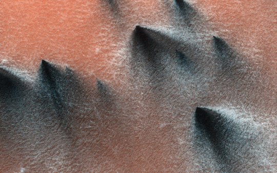
#image credit: NASA/JPL-Caltech/University of Arizona
Explore tagged Tumblr posts
Visit Tumblr Blog
Explore Tumblr blogs with no restrictions, modern design and the best experience.
Last Seen Tumblr Blogs


Fun Fact
Kazakhstan’s Minister of Communications and Informatics has blocked the Tumblr site because it contained 60 sites of terrorism, extremism, and pornography in 2015.
Text
The celestial object of the day is Phobos!
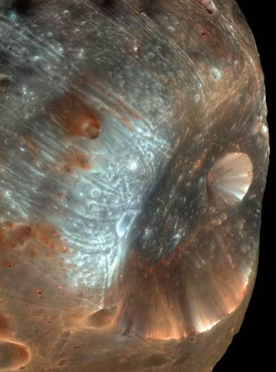
It's Mars's largest moon with 21 km (13 mi), it orbits Mars at only 6,000 km (3,700 mi) and it gets closer by 1.8 meters every year, at that rate is expected to collide with Mars or form a planetary ring in about 30-50 million years!
#image credit: NASA/JPL-Caltech/University of Arizona#The first picture is a photo of the Stickney crater#And is named after Chloe Angeline Stickney Hall who helped discover both Martian moons!#She was so cool kinda sad that her work wasn't properly paid only because she was a woman :(#sorry for the rant#I just really like astronomy history#Ok now to the actual tags#astrophotography#astronomy#nasa photos#nasa#space photography#outer space#space exploration#space#celestial object of the day#mars#phobos#moons
148 notes
·
View notes
Text
Playful Martian Dust Devils
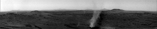
The Martian atmosphere lacks the density to support tornado storm systems, but vortices are nevertheless a frequent occurrence. As sun-warmed gases rise, neighboring air rushes in, bringing with it any twisted shred of vorticity it carries. (Video and image credit: NASA/JPL-Caltech/LANL/CNES/CNRS/INTA-CSIC/Space Science Institute/ISAE-Supaero/University of Arizona; via Gizmodo) Read the full article
#atmospheric science#conservation of angular momentum#dust devils#fluid dynamics#Mars#physics#science#vorticity
77 notes
·
View notes
Text

NASA orbiter spots Curiosity rover making tracks to next science stop
NASA's Curiosity Mars rover has never been camera shy, having been seen in selfies and images taken from space. But on Feb. 28—the 4,466th Martian day, or sol, of the mission—Curiosity was captured in what is believed to be the first orbital image of the rover mid-drive across the red planet.
Taken by the HiRISE (High-Resolution Imaging Science Experiment) camera aboard NASA's Mars Reconnaissance Orbiter, the image shows Curiosity as a dark speck at the front of a long trail of rover tracks. Likely to last for months before being erased by wind, the tracks span about 1,050 feet (320 meters).
They represent roughly 11 drives starting on Feb. 2 as Curiosity trucked along at a top speed of 0.1 mph (0.16 kph) from Gediz Vallis channel on the journey to its next science stop: a region with potential boxwork formations, possibly made by groundwater billions of years ago.
How quickly the rover reaches the area depends on a number of factors, including how its software navigates the surface and how challenging the terrain is to climb. Engineers at NASA's Jet Propulsion Laboratory in Southern California, which leads Curiosity's mission, work with scientists to plan each day's trek.
"By comparing the time HiRISE took the image to the rover's commands for the day, we can see it was nearly done with a 69-foot drive," said Doug Ellison, Curiosity's planning team chief at JPL.
Designed to ensure the best spatial resolution, HiRISE takes an image with the majority of the scene in black and white and a strip of color down the middle. While the camera has captured Curiosity in color before, this time the rover happened to fall within the black-and-white part of the image.
In the new image, Curiosity's tracks lead to the base of a steep slope. The rover has since ascended that slope since then, and it is expected to reach its new science location within a month or so.
IMAGE: NASA’s Curiosity rover appears as a dark speck in this contrast-enhanced view captured on Feb. 28, 2025, by the HiRISE camera aboard NASA’s Mars Reconnaissance Orbiter. Trailing Curiosity are the rover’s tracks, which can linger on the Martian surface for months before being erased by the wind. Credit: NASA/JPL-Caltech/University of Arizona
17 notes
·
View notes
Text

A Martian dust devil can be seen consuming its smaller friend in this short video made of images taken at the rim of Jezero Crater by NASA’s Perseverance Mars rover on January 25, 2025. Credit: NASA/JPL-Caltech/LANL/CNES/CNRS/INTA-CSIC/Space Science Institute/ISAE-Supaero/University of Arizona
0 notes
Link
The surface of Mars is hostile and unforgiving. But put a few meters of regolith between you and the Martian sky, and the place becomes a little more habitable. Cave entrances from collapsed lava tubes could be some of the most interesting places to explore on Mars, since not only would they provide shelter for future human explorers, but they could also be a great place to find biosignatures of microbial life on Mars. But cave entrances are difficult to spot, especially from orbit, as they blend in with the dusty background. A new machine learning algorithm has been developed to quickly scan images of the Martian surface, searching for potential cave entrances. Researchers Thomas Watson and James Baldini from Durham University in the UK used a convolutional neural network (CNN), trained to identify potential cave entrances (PCEs) from images of the Martian surface to locate new potential caves. It was able to identify 61 new cave entrances from images in four different regions on Mars. Previously, most detections of Martian PCEs have come from a manual review of visible satellite imagery, with images taken by the Mars Reconnaissance Orbiter’s (MRO) Context Camera (CTX) and High-Resolution Imaging Science Experiment (HiRISE) cameras. A database from that manual review called the Mars Global Candidate Cave Catalogue (MGC3) contains the coordinates and brief descriptions of over one thousand identified PCEs on Mars. The circular black features in this 2007 figure are caves formed by the collapse of lava tubes on Mars. Image credit: NASA/JPL-Caltech/ASU/USGS “Manual review of satellite imagery for Martian cave detection is far from efficient on a planet-wide scale,” wrote Watson and Baldini in their paper, published in the journal Icarus, “due to the time constraints associated with reviewing such a large dataset. Machine learning presents an intriguing solution to this problem, reducing the dataset to only include imagery computationally determined to contain a PCE.” The caves on Mars are created by lava tubes, which were formed by flowing lava on ancient Mars. As the outside of the flowing lava cooled and solidified into a ceiling and walls, the interior stayed molten and kept flowing. Eventually, the lava flowed out of the tube in a downslope direction, leaving the tube intact and open. Sometimes these lava tubes are apparent from linear pit chains on the surface – many of which are likely connected linearly underground. But more commonly, they are found by locating a “skylight” or collapsed lava tube ceiling in an orbital image. That skylight provides an entrance to the underground cave. This is a collapsed ceiling of a Martian lava tube. It measures 50 meters (150 ft) across, much larger than any Earth lava tubes. Image Credit: NASA/JPL/University of Arizona Lava tubes can be found on Earth, the Moon, and Mars. Even though Earth is larger than Mars, some incredibly large lava tubes have been found on Mars, bigger than those found on Earth. On Earth, lava tubes are usually only as large as 14–15 meters (46–49 ft) wide – and typically much narrower. In 2020, the HiRISE (High-Resolution Imaging Science Experiment) camera on NASA’s Mars Reconnaissance Orbiter (MRO) took a picture of a collapsed lava tube ceiling that is pit crater is 50 m (150 ft) across. The subsurface lava tube cave is likely larger than that. Regular neural networks are commonly used for natural language processing and speech recognition. But CNNs or ConvNets are more often utilized for classification and computer vision tasks. CNNs can recognize patterns in images and provide image classification and object recognition to projects both large and small. For example, in a previous study, CNNs were trained to recognize Martian surface features, such as craters, and achieved accuracies of more 90% Watson and Baldini created and trained their CNN model, called CaveFinder by having it look at images from the MGC3 catalog from the Tharsis and Elysium regions on Mars, which has the highest concentrations of volcanoes. Elevation map of Martian surface with five survey regions highlighted. The Tharsis and Elysium Bulges and the Hellas Basin are also highlighted. Map created using MOLA Shaded relief/ colorized digital elevation map from JMARS. Credit: Watson and Baldini/Icarus. After the training period, CaveFinder achieved a test accuracy of 77%. It found four PCEs that Watson and Baldini highlighted for having specific qualities that make them interesting for further research, including one PCE nicknamed Marvin, which was the largest PCE identified, as well as another they called Emily, whose low altitude could enable surveyance by drone. Additionally, CaveFinder identified twelve regions that appear to have multiple PCEs, which the authors say be a great place to explore multiple caves with a future mission, due to the proximity and abundance of PCEs. But the researchers say that CaveFinder needs more work before being used on a large, planet-wide database. It had a large number of false positives, and it appears to have a limited ability to identify “lone small cave types, such as skylights and pinholes.” “CaveFinder is still not considered appropriate for detection on a planet-wide scale, due to the high number of false positive outputs requiring manual assessment,” Watson and Baldini wrote. “However, it could prove effective in smaller regions perhaps already known to contain PCEs.” For future tests, they plan to increase the size of the training dataset used. Other ideas for improving CaveFinder’s accuracy is to use thermal imagery alongside the visible data. Higher resolution images from a future Mars orbiter would also be beneficial for CaveFinder’s increased detection and accuracy. “Overall, this survey’s findings indicate that, with these additions, machine learning has a great potential to advance remote cave detection, which is key to future Martian exploration,” the researchers concluded. The post Machine Learning Could Find all the Martian Caves We Could Ever Want appeared first on Universe Today.
0 notes
Text
AI Is Helping Scientists Discover Fresh Craters on Mars
The HiRISE camera aboard NASA’s Mars Reconnaissance Orbiter took this image of a crater cluster on Mars, the first-ever to be discovered AI. The AI-first spotted the craters in photos taken by the orbiter’s Context Camera; scientists followed up with this HiRISE image to confirm the cavities. Credit: NASA/JPL-Caltech/University of Arizona It’s the first time machine learning has been used to…
View On WordPress
0 notes
Text
The Mars Reconnaissance Orbiter (MRO) captured this bit of ursine pareidolia on Dec. 12, 2022. While it resembles a bear we might see on Earth, this is actually a hill on Mars with a peculiar shape. A V-shaped collapse structure makes the nose, two craters form the eyes, and a circular fracture pattern shapes the head. The circular fracture pattern might be due to the settling of a deposit over a buried impact crater.
Launched on August 12, 2015, the MRO studies the history of water on Mars and observes small-scale features on the planet’s surface. See more examples of pareidolia—the human tendency to see recognizable shapes in unfamiliar objects or data—from Mars.
Image Credit: NASA/JPL-Caltech/University of Arizona
instagram
0 notes
Text

#Victoria crater#This image from the High Resolution Imaging Science Experiment on NASA's Mars Reconnaissance Orbiter shows an impact crater at Meridiani Pl#near the equator of Mars. (Image credit: NASA/JPL-Caltech/University of Arizona/Cornell/Ohio State University )
1 note
·
View note
Photo

These six infrared images of Saturn’s moon Titan represent some of the clearest, most seamless-looking global views of the icy moon’s surface produced so far.
The views were created using 13 years of data acquired by the Visual and Infrared Mapping Spectrometer (VIMS) instrument on board NASA’s Cassini spacecraft.
Image credit: NASA/JPL-Caltech/University of Nantes/University of Arizona
#art#photography#space#cosmos#cosmic#universe#saturn#moon#titan#NASA#Cassini#spacecraft#jpl-caltech#universityofnates#universityofarizona#wallpaper#titan wallpaper#ice#planets
34 notes
·
View notes
Text
NASA shares spectacular images upon Perseverance rover landing on Mars

- By Nuadox Crew -
On February 19, NASA shared a series of spectacular images after its Perseverance rover landed on Planet Mars a day earlier.

Image: This is a high-resolution still image, part of a video taken by several cameras as NASA’s Perseverance rover touched down on Mars. A camera aboard the descent stage captured this shot. Credit: NASA/JPL-Caltech.

Image: This high-resolution image shows one of the six wheels aboard NASA’s Perseverance Mars rover, which landed on Feb.18, 2021. Credit: NASA/JPL-Caltech.

Image: This is the first high-resolution, color image to be sent back by the Hazard Cameras (Hazcams) on the underside NASA’s Perseverance Mars rover after its landing on Feb. 18, 2021. Credit: NASA/JPL-Caltech.

Image: The descent stage holding NASA’s Perseverance rover can be seen falling thorough the Martian atmosphere, its parachute trailing behind, in this image taken on Feb. 18, 2021by the HiRISE camera aboard the Mars Reconnaissance Orbiter. An ellipse indicates where Perseverance eventually touched down within Jezero Crater. Credit: NASA/JPL-Caltech/University of Arizona.
--
Header image courtesy of Alexander Antropov from Pixabay. It is reproduced under a Pixabay License.
Read Also
Mars 2020: The hunt for life on the red planet is about to get serious
NASA’s Maven observes martian night sky pulsing in ultraviolet light
2 notes
·
View notes
Text
Reimagining Mars' Interior

Older models of Mars assumed a liquid metal core beneath a solid mantle of silicates, but recent studies indicate that structure is missing at least one layer. Using data from the InSight lander's seismometer, two teams independently calculated that a liquid silicate layer must surround the planet's core. (Image credit: Mars - NASA/JPL-Caltech/University of Arizona, illustration - J. Sieben/J. Keisling; research credit: H. Samuel et al. and A. Khan et al.; via Physics Today) Read the full article
172 notes
·
View notes
Text
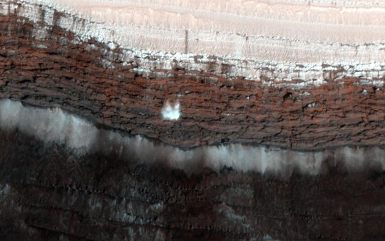
Martian spring involves lots of cracking ice, which led to this 66-foot-wide (20-meter-wide) chunk of carbon dioxide frost captured in freefall by the HiRISE camera aboard NASA's Mars Reconnaissance Orbiter in 2015. Credit: NASA/JPL-Caltech/University of Arizona
As light shines through carbon dioxide ice on Mars, it heats up its bottom layers, which, rather than melting into a liquid, turn into gas. The buildup gas eventually results in explosive geysers that toss dark fans of debris on to the surface. Credit: NASA/JPL-Caltech/University of Arizona
Sometimes, after carbon dioxide geysers have erupted from ice-covered areas on Mars, they leave scour marks on the surface. When the ice is all gone by summer, these long scour marks look like the legs of giant spiders. Credit: NASA/JPL-Caltech/University of Arizona
As temperatures rise, powerful winds kick up that carve deep troughs into the ice cap of Mars' north pole. Some of these troughs are as long as California, and give the Martian north pole its trademark swirls. This image was captured by NASA's now-inactive Mars Global Surveyor. Credit: NASA/JPL-Caltech/MSSS
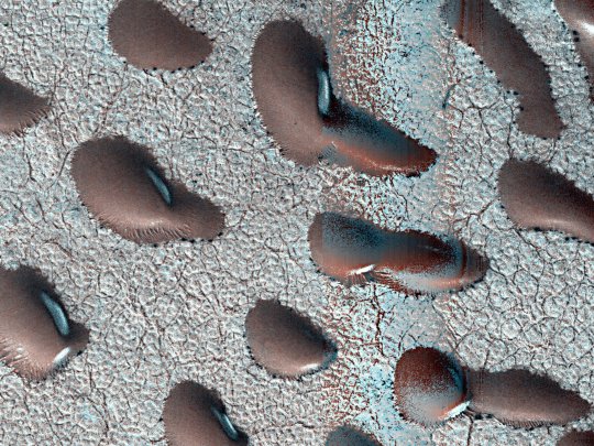
Surrounded by frost, these Martian dunes in Mars' northern hemisphere were captured from above by NASA's Mars Reconnaissance Orbiter using its HiRISE camera on Sept. 8, 2022. Credit: NASA/JPL-Caltech/University of Arizona
Avalanches, icy explosions and dunes: NASA is tracking New Year on Mars
Instead of a winter wonderland, the Red Planet's northern hemisphere goes through an active—even explosive—spring thaw. While New Year's Eve is around the corner here on Earth, Mars scientists are ahead of the game: The Red Planet completed a trip around the sun on Nov. 12, 2024, prompting a few researchers to raise a toast.
But the Martian year, which is 687 Earth days, ends in a very different way in the planet's northern hemisphere than it does in Earth's northern hemisphere: While winter's kicking in here, spring is starting there. That means temperatures are rising and ice is thinning, leading to frost avalanches crashing down cliffsides, carbon dioxide gas exploding from the ground, and powerful winds helping reshape the north pole.
"Springtime on Earth has lots of trickling as water ice gradually melts. But on Mars, everything happens with a bang," said Serina Diniega, who studies planetary surfaces at NASA's Jet Propulsion Laboratory in Southern California.
Mars' wispy atmosphere doesn't allow liquids to pool on the surface, like on Earth. Instead of melting, ice sublimates, turning directly into a gas. The sudden transition in spring means a lot of violent changes as both water ice and carbon dioxide ice—dry ice, which is much more plentiful on Mars than frozen water—weaken and break.
"You get lots of cracks and explosions instead of melting," Diniega said. "I imagine it gets really noisy."
Using the cameras and other sensors aboard NASA's Mars Reconnaissance Orbiter (MRO), which launched in 2005, scientists study all this activity to improve their understanding of the forces shaping the dynamic Martian surface. Here's some of what they track.
Frost avalanches
In 2015, MRO's High-Resolution Imaging Science Experiment (HiRISE) camera captured a 66-foot-wide (20-meter-wide) chunk of carbon dioxide frost in freefall. Chance observations like this are reminders of just how different Mars is from Earth, Diniega said, especially in springtime, when these surface changes are most noticeable.
"We're lucky we've had a spacecraft like MRO observing Mars for as long as it has," Diniega said. "Watching for almost 20 years has let us catch dramatic moments like these avalanches."
Gas geysers
Diniega has relied on HiRISE to study another quirk of Martian springtime: gas geysers that blast out of the surface, throwing out dark fans of sand and dust. These explosive jets form due to energetic sublimation of carbon dioxide ice. As sunlight shines through the ice, its bottom layers turn to gas, building pressure until it bursts into the air, creating those dark fans of material.
But to see the best examples of the newest fans, researchers will have to wait until December 2025, when spring starts in the southern hemisphere. There, the fans are bigger and more clearly defined.
Spiders
Another difference between ice-related action in the two hemispheres: Once all the ice around some northern geysers has sublimated in summer, what's left behind in the dirt are scour marks that, from space, look like giant spider legs. Researchers recently re-created this process in a JPL lab.
Powerful winds
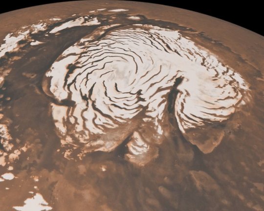
For Isaac Smith of Toronto's York University, one of the most fascinating subjects in springtime is the Texas-size ice cap at Mars' north pole. Etched into the icy dome are swirling troughs, revealing traces of the red surface below. The effect is like a swirl of milk in a café latte.
"These things are enormous," Smith said, noting that some are a long as California. "You can find similar troughs in Antarctica but nothing at this scale."
Fast, warm wind has carved the spiral shapes over eons, and the troughs act as channels for springtime wind gusts that become more powerful as ice at the north pole starts to thaw. Just like the Santa Ana winds in Southern California or the Chinook winds in the Rocky Mountains, these gusts pick up speed and temperature as they ride down the troughs—what's called an adiabatic process.
Wandering dunes
The winds that carve the north pole's troughs also reshape Mars' sand dunes, causing sand to pile up on one side while removing sand from the other side. Over time, the process causes dunes to migrate, just as it does with dunes on Earth.
This past September, Smith coauthored a paper detailing how carbon dioxide frost settles on top of polar sand dunes during winter, freezing them in place. When the frost all thaws away in the spring, the dunes begin migrating again.
Each northern spring is a little different, with variations leading to ice sublimating faster or slower, controlling the pace of all these phenomena on the surface. And these strange phenomena are just part of the seasonal changes on Mars: the southern hemisphere has its own unique activity.
9 notes
·
View notes
Text
Celebrate Mars Reconnaissance Orbiter's Views From Above
NASA - Mars Reconnaissance Orbiter (MRO) patch. Aug. 12, 2020 Marking its 15th anniversary since launch, one of the oldest spacecraft at the Red Planet has provided glimpses of dust devils, avalanches, and more.
Image above: Five images taken by the HiRISE camera aboard NASA's Mars Reconnaissance Orbiter, which launched 15 years ago, on Aug. 12, 2005. Along with being a rich source of images for research, MRO studies atmospheric temperatures, peers underground with radar, and detects minerals on the planet's surface. Image Credits: NASA/JPL-Caltech/University of Arizona. Since leaving Earth 15 years ago, NASA's Mars Reconnaissance Orbiter has reshaped our understanding of the Red Planet. The veteran spacecraft studies temperatures in Mars' thin atmosphere, peers underground with radar, and detects minerals on the planet's surface. But perhaps what it's become best known for are stunning images. Among its instruments, MRO carries three cameras: The Mars Color Imager (MARCI) has a fisheye lens that produces a daily global view. The Context Camera (CTX) provides 19-mile-wide (30-kilometer-wide) black-and-white terrain shots. Those images, in turn, offer context for the tightly focused images provided by MRO's third camera, the High-Resolution Imaging Science Experiment (HiRISE), which produces the most striking views.
Mars Reconnaissance Orbiter (MRO). Image Credits: NASA/JPL-Caltech
Able to zoom in on surface features at the highest resolution, the detailed, color images from HiRISE have captured dramatic scenes of nature: tumbling avalanches, skyscraping dust devils, and other features of a changing landscape. The camera has also provided images of other NASA spacecraft at Mars, like the Curiosity and Opportunity rovers. MRO has even flipped itself around to point HiRISE out at Earth and Phobos, one of Mars' two moons. As of early August, HiRISE alone had taken 6,882,204 images, generating 194 terabytes of data sent from Mars since 2006. The following images are just a glimpse of the amazing work performed by all three cameras aboard MRO, which is managed by NASA's Jet Propulsion Laboratory in Southern California. Welcome to Mars
Image Credits: NASA/JPL-Caltech/MSSS
Dust storms are routine on Mars. Most are limited to small regions and are not as dramatic as what's portrayed in movies. But once or twice a decade, a series of regional storms will create a domino effect, lifting enough dust for winds to cover the surface in what's called a "planet-encircling dust event." This one, captured by MARCI in the summer of 2018, darkened the region above the Opportunity rover, depriving its solar panels of sunlight and ultimately leading to the end of the mission. A Martian Sky Scraper
Image Credits: NASA/JPL-Caltech/Univ. of Arizona
As HiRISE pans over large swaths of Mars' surface, it occasionally discovers surprises like this towering dust devil, which was captured from 185 miles (297 kilometers) above the ground. The length of this whirlwind's shadow indicates that it was more than half a mile (800 meters) high – about the size of the United Arab Emirate's Burj Khalifa, the tallest building on Earth. Avalanche Alert
Image Credits: NASA/JPL-Caltech/University of Arizona
HiRISE has captured avalanches in action. As seasonal ice vaporized in the spring, these 1,640-foot-tall (500-meter-tall) cliffs at Mars' north pole began to crumble. Such cliffs reveal the deep time scales on the planet, exposing the many layers of ice and dust that have settled during different eras. Like the rings of a tree, each layer has a story to tell scientists about how the environment was changing. That's Going to Leave a Dent
Image Credits: NASA/JPL-Caltech/Univ. of Arizona
Mars has a thin atmosphere – just 1% as dense as Earth's. As a result, there's less of a protective barrier to burn up space debris. That means larger meteors make it through the Red Planet's atmosphere than Earth's. CTX has detected over 800 new impact craters during MRO's mission. After CTX spotted this one, scientists took a more detailed image with HiRISE. The crater spans approximately 100 feet (30 meters) in diameter and is surrounded by a large, rayed blast zone. In examining the distribution of ejecta – the debris tossed outward during the formation of a crater – scientists can learn more about the impact event. The explosion that created this crater threw ejecta as far as 9.3 miles (15 kilometers). The Face of Time
Image Credits: NASA/JPL-Caltech/University of Arizona
Land changes over time, so having a spacecraft at Mars for years offers a unique perspective. "The more we look, the more we discover," said Leslie Tamppari, MRO's deputy project scientist at JPL. "Before MRO, it wasn't clear what on Mars really changed, if anything. We thought the atmosphere was so thin that there was almost no sand motion and most dune movement happened in the ancient past." We now know that's not the case. "False color" has been added to this image to accentuate certain details, like the tops of dunes and ripples. Many of these landforms are migrating, as they do on Earth: Sand grain by sand grain, they're carried by wind, crawling across the planet over millions of years. Back Atcha, Earth
Image Credits: NASA/JPL-Caltech/Univ. of Arizona
MRO hasn't only looked at Mars. This composite, made from four sets of HiRISE images of Earth and our Moon, was actually the second time that HiRISE had captured our home planet. Fearsome Moon
Image Credits: NASA/JPL-Caltech/University of Arizona
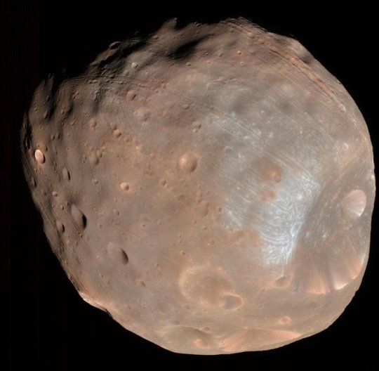
Named for the Greek god of fear, Phobos is one of Mars' two moons (Deimos, named for the god of terror, is the other), and it's only about 13 miles (21 kilometers) across. Stickney Crater, the indentation on the moon's lower right, is about 5.6 miles (9 kilometers) wide in this HiRISE image. Despite its small size, Phobos is of great interest to scientists: Is it a captured asteroid, or a chunk of Mars that broke off after a massive impact? A Japanese mission is scheduled to launch to Phobos in the near future, and the moon has been proposed as a staging ground for astronauts before they go to Mars. Mapmaker's Tool
Image Credits: NASA/JPL-Caltech/MSSS
Based on an image from CTX, this map shows the complete traverse of the Opportunity rover after exploring the planet for more than 15 years. Both HiRISE and CTX are used by scientists to make maps of landing sites for future human and robotic missions as well as to chart the progress of rovers on the ground. Making Treks
Animation Credits: NASA/JPL-Caltech/University of Arizona
HiRISE has frequently been used to snap images of NASA spacecraft on the Martian surface, capturing Spirit, Opportunity, and Curiosity as well as the stationary landers Phoenix and InSight. NASA's newest rover, Perseverance, is currently on its way to Jezero Crater. After it arrives on Feb. 18, 2021, you can bet there will be some images of it as well. The Eyes Have It
Animation Credits: NASA/JPL-Caltech/Univ. of Arizona
It takes sharp eyes to find unique features on Mars, like recurring slope lineae. These dark streaks appear in the same places at around the same times of year. It was initially proposed they were caused by brine, since salt could allow water to remain liquid in the thin Martian atmosphere. The consensus now, however, is that they're actually caused by dark sand sliding down inclines. The streaks were discovered by Lujendra Ojha, who was an undergraduate at the University of Arizona, which operates the HiRISE camera, and now is a professor at Rutgers University. "Sometimes you're just looking at the right place at the right time," Ojha said. "I was completely baffled when I first spotted this, because I was just a student at the time – I wasn't even in a planetary program." Undergraduates work alongside experienced scientists to spot unique features like these in HiRISE images. Want to see more? Scientists and the public can request specific kinds of MRO images. For more information about MRO: https://mars.nasa.gov/mro/ https://www.nasa.gov/mission_pages/MRO/main/index.html JPL, a division of Caltech in Pasadena, California, manages the MRO mission for NASA's Science Mission Directorate in Washington. The University of Arizona, in Tucson, operates HiRISE, which was built by Ball Aerospace & Technologies Corp., in Boulder, Colorado. MARCI and the Context Camera were both built and are operated by Malin Space Science Systems in San Diego. Images (mentioned), Animations (mentioned), Text, Credits: NASA/Tony Greicius/Alana Johnson/Grey Hautaluoma/JPL/DC Agle. Greetings, Orbiter.ch Full article
11 notes
·
View notes
Link
5 min readPreparations for Next Moonwalk Simulations Underway (and Underwater) At the end of a long-haul road trip, it might be time to kick up your feet and rest awhile – especially if it was a seven-year, 4 billion-mile journey to bring Earth a sample of asteroid Bennu. But OSIRIS-REx (Origins, Spectral Interpretation, Resource Identification and Security – Regolith Explorer), the NASA mission that accomplished this feat in September, is already well on its way (with a new name) to explore a new destination. When OSIRIS-REx left Bennu in May 2021 with a sample aboard, its instruments were in great condition, and it still had a quarter of its fuel left. So instead of shutting down the spacecraft after it delivered the sample, the team proposed to dispatch it on a bonus mission to asteroid Apophis, with an expected arrival in April 2029. NASA agreed, and OSIRIS-APEX (Origins, Spectral Interpretation, Resource Identification, and Security – Apophis Explorer) was born. A Rare Opportunity at Apophis After considering several destinations (including Venus and various comets), NASA chose to send the spacecraft to Apophis, an “S-type” asteroid made of silicate materials and nickel-iron – a fair bit different than the carbon-rich, “C-type” Bennu. The intrigue of Apophis is its exceptionally close approach of our planet on April 13, 2029. Although Apophis will not hit Earth during this encounter or in the foreseeable future, the pass in 2029 will bring the asteroid within 20,000 miles (32,000 kilometers) of the surface – closer than some satellites, and close enough that it could be visible to the naked eye in the Eastern Hemisphere. Scientists estimate that asteroids of Apophis’ size, about 367 yards across (about 340 meters), come this close to Earth only once every 7,500 years. These images of asteroid Apophis were recorded in March 2021 by radio antennas at the Deep Space Network’s Goldstone complex in California and the Green Bank Telescope in West Virginia. The asteroid was 10.6 million miles (17 million kilometers) away, and each pixel has a resolution of 127 feet (38.75 meters).Credit: NASA/JPL-Caltech and NSF/AUI/GBO “OSIRIS-APEX will study Apophis immediately after such a pass, allowing us to see how its surface changes by interacting with Earth’s gravity,” said Amy Simon, the mission’s project scientist based at NASA’s Goddard Space Flight Center in Greenbelt, Maryland. Apophis’ close encounter with Earth will change the asteroid’s orbit and the length of its 30.6-hour day. The encounter also may cause quakes and landslides on the asteroid’s surface that could churn up material and uncover what lies beneath. “The close approach is a great natural experiment,” said Dani Mendoza DellaGiustina, principal investigator for OSIRIS-APEX at the University of Arizona in Tucson. “We know that tidal forces and the accumulation of rubble pile material are foundational processes that could play a role in planet formation. They could inform how we got from debris in the early solar system to full-blown planets.” Apophis represents more than just the opportunity to learn more about how solar systems and planets form: As it happens, most of the known potentially hazardous asteroids (those whose orbits come within 4.6 million miles of Earth) are also S-types. What the team learns about Apophis can inform planetary defense research, a top priority for NASA. OSIRIS-APEX: Travel Itinerary By April 2, 2029 – around two weeks before Apophis’ close encounter with Earth – OSIRIS-APEX’s cameras will begin taking images of the asteroid as the spacecraft catches up to it. Apophis will also be closely observed by Earth-based telescopes during this time. But in the hours after the close encounter, Apophis will appear too near the Sun in the sky to be observed by ground-based optical telescopes. This means any changes triggered by the close encounter will be best detected by the spacecraft. This animation depicts the orbital trajectory of asteroid 99942 Apophis as it zooms safely past Earth on April 13, 2029. Earth’s gravity will slightly deflect the trajectory as the 1,100-foot-wide (340-meter-wide) near-Earth object comes within 20,000 miles (32,000 kilometers) of our planet’s surface. The motion has been sped up 2,000 times.Credit: NASA/JPL-Caltech OSIRIS-APEX will arrive at the asteroid on April 13, 2029, and operate in its proximity for about the next 18 months. In addition to studying changes to Apophis caused by its Earth encounter, the spacecraft will conduct many of the same investigations OSIRIS-REx did at Bennu, including using its instrument suite of imagers, spectrometers, and a laser altimeter to closely map the surface and analyze its chemical makeup. As an encore, OSIRIS-APEX will reprise one of OSIRIS-REx’s most impressive acts (minus sample collection), dipping within 16 feet of the asteroid’s surface and firing its thrusters downward. This maneuver will stir up surface rocks and dust to give scientists a peek at the material that lies below. Although the rendezvous with Apophis is more than five years away, the next milestone on its journey is the first of six close Sun passes. Those near approaches, along with three gravity assists from Earth, will put OSIRIS-APEX on course to reach Apophis in April 2029. What OSIRIS-APEX will discover about Apophis remains to be seen, but if the mission’s previous incarnation is any indication, surprising science lies ahead. “We learned a lot at Bennu, but now we’re armed with even more questions for our next target,” Simon said. — NASA’s Goddard Space Flight Center provides overall mission management, systems engineering, and the safety and mission assurance for OSIRIS-APEX. Dani Mendoza DellaGiustina of the University of Arizona, Tucson, is the principal investigator. The university leads the science team and the mission’s science observation planning and data processing. Lockheed Martin Space in Littleton, Colorado, built the spacecraft and provides flight operations. Goddard and KinetX Aerospace are responsible for navigating the OSIRIS-APEX spacecraft. International partnerships on this mission include the spacecraft’s laser altimeter instrument from CSA (the Canadian Space Agency) and science collaboration with JAXA’s (the Japan Aerospace Exploration Agency) Hayabusa2 mission. OSIRIS-APEX (previously named OSIRIS-REx) is the third mission in NASA’s New Frontiers Program, managed by NASA’s Marshall Space Flight Center in Huntsville, Alabama, for the agency’s Science Mission Directorate in Washington. By Lonnie Shekhtman and Rob GarnerNASA’s Goddard Space Flight Center, Greenbelt, Md. Facebook logo @NASASolarSystem@NASAGoddard @NASASolarSystem@NASAGoddard Instagram logo @NASASolarSystem@NASAGoddard Share Details Last Updated Dec 22, 2023 EditorRob GarnerContactRob [email protected] Space Flight Center Related TermsOSIRIS-APEX (Origins, Spectral Interpretation, Resource Identification, and Security – Apophis Explorer)AsteroidsGoddard Space Flight CenterThe Solar System
0 notes
Text

Capturing an Avalanche on Mars
Hi-RISE, the High-Resolution Imaging Science Experiment camera aboard NASA's Mars Reconnaissance Orbiter (MRO) captured this avalanche plunging down a 1,640-foot-tall (500-meter-tall) cliff on May 29, 2019. The image also reveals layers at Mars' north pole during spring. As temperatures increase and vaporize ice, the destabilized ice blocks break loose and kick up dust.
Learn more as we mark the 15th anniversary since the launch of MRO, one of the oldest spacecraft at the Red Planet, which has provided glimpses of dust devils, avalanches, and more.
Image Credit: NASA/JPL-Caltech/University of Arizona
#nasa picture of the day#awesome#beautiful pics#beautiful#picoftheday#photography#science#astronomy#space#space news
10 notes
·
View notes
Photo

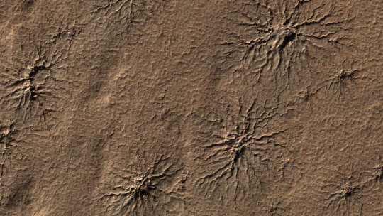
the red planet. a field of sand dunes occupies this frosty 5-kilometer diameter crater in the high-latitudes of the northern plains of mars. some dunes have separated from the main field and appear to be climbing up the crater slope along a gully-like form. Image Credit: NASA/JPL-Caltech/University of Arizona #theredplanet #mars #sanddunes #lifeonmars https://instagr.am/p/CNCXzlmLMx0/
1 note
·
View note