#ksstorms
Explore tagged Tumblr posts
Visit Tumblr Blog
Explore Tumblr blogs with no restrictions, modern design and the best experience.
Last Seen Tumblr Blogs


Fun Fact
The Tumblr office adopted Tommy, an 11-year-old Pomeranian.
Photo

A warmup in temperatures is expected after sunset this evening, and as a result #severe #thunderstorms will be possible beginning late tonight. This will most likely begin after midnight and continue through 6:00 AM tomorrow morning. We could be looking at #hail up to 2 inches in diameter and #winds between 60 and 70 miles per hour. More severe #storms will be possible Wednesday afternoon and evening, but current do not look to last too late. Any #storm that occurs looks to be isolated in nature... which means the good news is that they could be hit-or-miss in nature and could pass us entirely, but the bad news is that this will increase the chance that any #thunderstorm that forms will be more intense and even potentially increase the #tornado risk (which is currently low but not very low); any storm that impacts us directly has real potential to be powerful. However, any storms that form tonight into tomorrow should do so far enough away for anyone monitoring for them should have plenty of time to see them coming. Severe weather is expected to continue Thursday through Saturday as well; all factors remain in play at this time for these days (with the risk of #flooding increasing as the week progresses), but timing is currently more uncertain. Be safe! #KSWX #ICTWX #KsStorms #WichitaWX (at Wichita, Kansas) https://www.instagram.com/p/CAF3m1hgDUb/?igshid=13jz7ycnzcaag
#severe#thunderstorms#hail#winds#storms#storm#thunderstorm#tornado#flooding#kswx#ictwx#ksstorms#wichitawx
1 note
·
View note
Photo

We got some hail. #ks #ksstorms #ksweather #spring #hail #weather #topeka #northtopeka (at North Topeka, Kansas) https://www.instagram.com/p/B-3JW6FJIMO/?igshid=4qgdjj7de830
0 notes
Photo
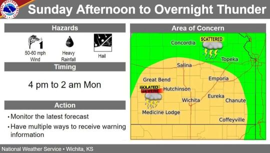
The potential for #severe #storms is still on the table for this Sunday between the late afternoon hours through most of the overnight hours. The primary hazards from #thunderstorm activity now look to be damaging #winds and large #hail, followed by the potential for torrential and #flooding #rainfall; the risk for #tornadoes is less likely, but an isolated #tornado or two also cannot be ruled out entirely. There is also a chance that the worst of the #thunderstorms (or even the entirety of the #storm system) could completely pass by to our south. Be safe! #KsWX #IctWX #KsStorms #WichitaWX (at Wichita, Kansas) https://www.instagram.com/p/CpDGSupr660/?igshid=NGJjMDIxMWI=
#severe#storms#thunderstorm#winds#hail#flooding#rainfall#tornadoes#tornado#thunderstorms#storm#kswx#ictwx#ksstorms#wichitawx
0 notes
Photo

#lightning photo no. 2 #stormchasing #storms #ksstorms (Taken with Instagram)
2 notes
·
View notes
Text
The lights are flickering, the wind is high and it looks kind of like hurricane footage out my window--so of course I've got the window open. All my plants have been dragged under the overhang on my balcony and I have a go bag packed for my basement. Yay?
1 note
·
View note
Photo

#ksstorms rising over downtown. (Taken with instagram)
1 note
·
View note
Photo

Here are the tornado probabilities for today from the latest Storm Prediction Center outlook (though another outlook is due out in the next hour). Compared to the first outlook of the day, the SPC has increased the max tornado risk from 10% to 15% and they've added a significant tornado area (the black hatched area). Significant tornadoes are defined as EF2 or greater on a scale from 0 to 5.
1 note
·
View note
Photo
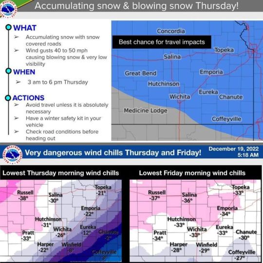
Incredibly dangerous weather will be very likely later this week. #Snow is possible beginning Wednesday night and lasting through the daytime on Thursday, with the best chances for the worst of the #snowfall being late Thursday afternoon through early Thursday evening. Then on Thursday night, the temperature will drop to between -5 and -10 degrees, with predicted #WindChills in the Wichita area currently projected to be as low as -35. If there is one silver lining, it is that the temperature is not expected to rise back above freezing until around next Monday; which means that enough snow accumulation will bring us a rare White Christmas. Be safe! #KsWX #IctWX #KSstorms #WichitaWX #WhiteChristmas (at Wichita, Kansas) https://www.instagram.com/p/CmWuck-O63Y/?igshid=NGJjMDIxMWI=
0 notes
Video
#ksstorms #trinabakerphotography #lawrencekansas
0 notes
Video
#nofilter look at those storm clouds moving! :) #ksstorms #kswx
0 notes
Photo

Both the timing and target zone of the #severe weather expected for Thursday have shifted. It is now looking like #thunderstorms will probably occur along and west of I-35 on Thursday evening, and this may not occur until around or after 9:00 PM (likely making this an overnight or very early Friday morning threat for the Wichita area). The primary risk for any #storm that develops will be #winds up to 65 miles per hour and quarter sized #hail. #Tornadoes will be possible, but the #tornado risk will decrease as the storms begin to merge into a line (which will also increase the threat for strong and widespread straight line winds). The #storms will likely have plenty of time to mature to full strength before reaching us, but this will also give us plenty of time to see them approaching. #Thunderstorm activity remains possible to a lesser degree on Friday and Saturday, and around 2 inches of total combined rainfall is expected by Saturday night. Be safe! #KsWX #IctWX #KsStorms #WichitaWX (at Wichita, Kansas) https://www.instagram.com/p/Ckdx4pyLcgR/?igshid=NGJjMDIxMWI=
#severe#thunderstorms#storm#winds#hail#tornadoes#tornado#storms#thunderstorm#kswx#ictwx#ksstorms#wichitawx
0 notes
Photo

Incredible video footage from inside an EF4 tornado here in Kansas earlier this week. Video: --> http://mbchp.me/InsideTornado
0 notes
Video
Daniel gets ready to shovel snow. #WichitaWhiteout #ksstorms #snowmageddon
0 notes