#sedimentary structures
Explore tagged Tumblr posts
Visit Tumblr Blog
Explore Tumblr blogs with no restrictions, modern design and the best experience.
Last Seen Tumblr Blogs


Fun Fact
Tumblr was acquired by Yahoo for $1.1B in 2013.
Text


Here are some ripple marks from a beach in the Northwest Scottish Highlands! There’s a chance that these ripple marks will be preserved like this and become sedimentary structures that we can see as cross-bedding in an outcrop someday!
#geology#rocks and minerals#rocks#sediment#sedimentary geology#sedimentary rock#northwest highlands geopark#sedimentary structures#ripple#ripple marks#I love sed geology sm and I get judged for it all the time by my peers#sed geologist#sedimentology
5 notes
·
View notes
Text

Bernoulli, Daniel (1936–, geologist). Flute casts, Walkers Bed, Scotland Fm, 28.05.1978.
Clastic sediments: mass flows, sedimentary structures. N of Bowden and River, St. Andrew, Barbados
What are flute casts? Find out here.
#Daniel Bernoulli#flute casts#sedimentary structures#rocks#geology#nature photography#texture#pattern#geologyfordummies
8 notes
·
View notes
Text

Huh, ya think it might have rained a little back then?
#maybe a little flood#possibly from some glaciers#could’ve occurred during the last ice age#but I guess we’ll never know#real tags now#geology#sedimentary rock#quaternary#Columbia basin#sedimentary structure
183 notes
·
View notes
Text

Outcrop of the day
#geologist#rocks are cool#tumblr people#photography#feldspar#clear quartz#serpentine gallery#metamorphic#igneous#sedimentary rock#structural geology#bearing
16 notes
·
View notes
Text
2 notes
·
View notes
Text
after 3 hours of back- and knee-breaking work i have transferred the corset pattern to one (1) of the cloths. i haven’t cut it yet because the cloth, while strong, also frays like a stressed unpaid intern, so i am going to sew a line halfway along the seam. (also to keep the curves from…de-curving).
i only have to do this three more times :)))
#yeah it’s four layers#the pretty one the stressed but indomitable intern one the lining one#and then one between the fancy and the intern ones#because the fancy is kinda see through#at least enough for the colour of the structural intern to fuck up the colours enough to bug me#i wish i were writing#but sedimentary me can’t write#(translation: day too shitty to word#which is ironic because sometimes shitty days are dealt with by writing#and yet)#randomness
0 notes
Text
Antediluvian Period Civilizations; Huge Stone Structures Found All Over The World, From Before The Great Flood
ANTEDILUVIAN PERIOD DEFINED IN MANY BOOKS Wikipedia; “The antediluvian (alternatively pre-diluvian or pre-flood) period is the time period chronicled in the Bible between the fall of man and the Genesis flood narrative in biblical cosmology. The term was coined by Thomas Browne. The narrative takes up chapters 1–6 (excluding the flood narrative) of the Book of Genesis. The term found its way…

View On WordPress
#adamitic#ancient#Antediluvian#before great flood#behemoth#Bible#Civilizations#creation story#disobedience to God#fallen angels#fallen angesl#fossils#garden of eden#genesis#giants#gibborim#leviathan#nephalim#pre adamitic#pre diluvian#pre flood#primary rock#sedimentary rock#six ages of the world#stone buildings#stone structures#wickedness
1 note
·
View note
Text
Bryce Canyon National Park, Utah, United States: Bryce Canyon National Park is a national park of the United States located in southwestern Utah. The major feature of the park is Bryce Canyon, which despite its name, is not a canyon, but a collection of giant natural amphitheaters along the eastern side of the Paunsaugunt Plateau. Bryce is distinctive due to geological structures called hoodoos, formed by frost weathering and stream erosion of the river and lake bed sedimentary rock. The red, orange, and white colors of the rocks provide spectacular views for park visitors. Wikipedia
#Bryce Canyon National Park#Garfield County#Kane County#Tropic#Panguitch#Utah#United States#north america#north america continent
527 notes
·
View notes
Text
I also don’t think anyone could really write anything like either Napkin or Fucking Trans Women now, in general. In the shadow of rhetorical warfare and actual persecution, trans writing about sex has acquired a curiously contradictory character. On one hand, it’s common to read personal writing by trans women that strives openly to “justify” our sexualities against charges of abusiveness or decadence. I’m really not like that, I promise. On the other hand, much recent trans writing tends to clam up around sex, refusing to explain or interrogate anything, adopting a faux-blasé confrontational stance that just serves to occlude our own lack of self-knowledge. Yeah, we’re perverts, what are you gonna do about it? Something has been lost: the cautious, serious exploration that Monir and Bellwether offered up, oriented toward pleasure and happiness, that is honest about what we know and don’t know about our bodies. This is a kind of writing that could realistically only exist when trans writers could expect to mostly reach an audience of their peers. Our cultural production is now everyone’s business, and professional rabble-rousers trawl the internet looking for easy targets. The battle lines have hardened. On the other hand, nothing can be fully undone. The trans literary production of the 2010s was on a radically different plane than what came before it, in large part because trans people, having found each other in large numbers in the 2010s, started to unbind the aggregated knots of our shame. Monir’s and Bellwether’s zines exemplify this. The grace and eloquence with which authors like Imogen Binnie and Torrey Peters deal with the confusing, awkward early sexual experiences of their trans characters is a parallel example. Sexuality in Nevada and The Masker is not peripheral, the way it was in the 20th-century memoirs, but central to the dynamics of plot and character in the way they are for everyone else. In its manifestation in variegated and contradictory forms, and in the way it has a sedimentary structure as experience accumulates and knowledge innervates it, sexuality is in fact a microcosm for subjectivity as a whole. It is psychologically maiming to coerce trans people to write sex out of our stories in order to be taken seriously—and it’s a form of lying to assume that we know ourselves well enough to take sex for granted. We revisit these zines to remember that knowledge is a thing to be won. We will need to assert again and again that our bodies deserve the careful attention—tinged with the primal confusion of adolescence—that is the soil from which self-knowledge can grow.
Nerves Nerves Nerves by Emily Zhou
144 notes
·
View notes
Text
Paleo-caves in Death Valley
You have probably heard of "caves", or a natural void formed in rock. Caves are formed in a number of ways, but the most familiar are probably those formed in limestone - called karst or karstic. Karst caves are formed by the steady dissolving of limestone rock by naturally acidic groundwater percolating through the ground, often along faults or other natural weak areas.
Death Valley in California is not a hotbed of limestone caves, though evidence of them can be seen in a number of places! Ancient caves, often tens or hundreds of millions of years old, sometimes collapse or fill in with silt/minerals/debris. An ancient cave formation is called "paleokarst", and there are a few areas in Death Valley where you can find it. The easiest to access is in Titus Canyon, a major canyon who's lowest reach carves its way through limestone bedrock, leaving behind towering polished rock walls and revealing the internal structure of the rock.

Titus Canyon's narrow section is carved through the Bonanza King Formation, a Cambrian-age (538 - 485 million years ago) marine sedimentary rock package several kilometers thick. It's found in many areas of Death Valley and the surrounding region. Across its area and thickness, it alternates from dolomite to limestone (dolomite minerals versus calcite minerals). Dolomite doesn't usually dissolve and form caves, but limestone does - and the many fractures in this rock appear to have allowed numerous tiny caves to form somewhere in the distant past. Most of these have since been filled in with calcite minerals, making them paleokarst.

In this image, you can see the void of the cave lined with thinly-layered calcite. It has a flat floor, and these features are characteristic of having formed in a cave. In Titus Canyon, we can find these from a few inches to a few meters across, and as the canyon has been carved into the rock, these voids are exposed. This one below tells an exceptionally clear story:

You don't need to be a geologist to see how this differs from the first example. There's a weird pendant-shaped protrusion hanging from the top, there are layers in the minerals, the bottom half is red… there's a lot going on. Let's get some lines on there and figure out what we can see:

That's better. OK - I've separated out the parts of this outcrop which from my desk look to be distinct. Here's a close-up of part of the left-center area to show how it appears different up close.

OK, so we have the blue-gray limestone bedrock on the right, top, and lower left, then a gray-red area with layers and what looks like gravel or other angular pieces of the limestone. Above that is a finely-layered calcite deposit (remember? that's cave-like!), and above that is a layer of calcite which is rather porous. The top surface of this area is sort of scalloped and curved, which is also characteristic of limestone caves.

Here's the fully interpreted version. Let's go through the sequence of events. First, we have the limestone bedrock of the Bonanza King Formation (BKL). At some time in the distant past, a portion of it dissolved away and formed a cave. Over time, silt and debris filled in the bottom of this cave. Because it is ancient, we call it paleo-fill (OPF). This might have happened at a time when the cave was dry (not containing water), since if it was wet we would expect some amount of calcite to be deposited around its perimeter as is typical in limestone caves.
Above that is a layer of thinly-layered calcite, the cave mineral. This layer contains some reddish silt and the occasional fragment of the limestone, so the cave was probably happily active during the time that was deposited! This is the oldest cave mineralization phase I can discern in this outcrop, so I call it Old Cave Calcite (OCC).
Next, we have a slightly porous, light-colored calcite deposit. The porosity suggests to me that it was deposited faster, but I am not an expert on cave deposits so will not comment further. This unit fills the cave to its top in most places! I call this the Middle-age cave calcite (MAC).
Finally, the youngest unit is another cave-deposited calcite (YCC). As in the first cave picture above, it is a coarser-grained pale yellow color with layers that parallel the sides of the void. Most of the paleo-caves you can find in Titus Canyon are filled with this sort of calcite, and it may be geologically recent (last million years?). It filled the final remnant of this ancient paleo-cave, and is contrasting with the material around it. This visual and textural contrast is what inspired me to write this post in the first place - the best example I've seen in person of paleo-karst and the evolution of a miniature cave system, right in the heart of Death Valley - my favorite place in the world.
#geology#photography#adventures#bettergeology#california#rocks#death valley#death valley national park#cave#paleokarst#limestone#california geology#geologia#i love rocks
97 notes
·
View notes
Text

Zebra Schist
Zebra Schist is The tightly folded, thinly bedded schists that are derived from sedimentary rocks that are exposed in Kangaroo Island are known as zebra schists. A quartz-rich and biotite-rich layering largely reflects original sedimentary layering rather than metamorphic differentiation as the secondary biotite preserves and outlines a variety of sedimentary structures.
Small cross-beds troughs and climbing ripples show a sequence facing south. The Geological Society of Australia
has designated this section of the coastline as a geological monument.
84 notes
·
View notes
Text

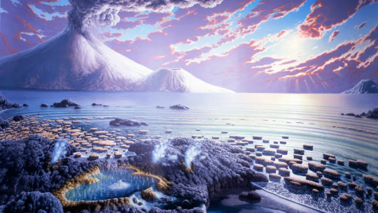
The Paleo Party Guest of the day is the Stromatolite!
Well, this is more of a sedimentary structure than a fossil, they're layers of silt trapped by successive layers of microbial mats! Many types of microorganisms can create stromatolites, like cyanobacteria and pseudomonadota!
Age: Possibly up to 3.4 billion years ago to present!
Stickers || Phone Wallpapers Masterlist
140 notes
·
View notes
Text

Daniel Bernoulli. Drag marks & superposed flute c., 9/1987.
Read about Sole markings here
#Daniel Bernoulli#photography#geology#rocks#sedimentary structures#texture#pattern#nature#geologyfordummies
1 note
·
View note
Text
The Three Rock Types
Hey folks! We’re back with, well, it was supposed to be one post - but it turns out there’s a character limit on tumblr and apparently we over-exceeded it by a lot to talk about rocks, haha! So, this next series of posts will be going over the three main rock types and how we can identify them!
As some of you probably know, in geology, there are three main rock types. They are all formed by different processes, have different defining characteristics, and different ways of classifying them. Fortunately, they all have very particular “looks” to them, features that you can use to separate them from each other easily!
For our second post in this series, we will be examining . . .
Sedimentary Rocks

Fig. 1: An image of one of the sandstone arches, formed by aeolian processes on Ember Twin.
Sedimentary rocks are formed when sediments (e.g. sand, silt, clay, pebbles, boulders, ash) accumulate and solidify into rocks, typically by burial and the pressure that brings with it. These sediments can be formed from pre-existing rocks that have been eroded down or fragments of living organisms, such as the shells of sea creatures.
Because sedimentary rocks are associated with erosional processes, they tend to form with the deposition of sediments by water, wind, or glaciers, giving us insight into the geological environment of a region at the time. The minerals present in these rocks, as well as grain size and structures like mudcracks or crossbedding, can all provide further context to how the rock was formed and how it evolved over time.
Because sedimentary rocks form by sediments being deposited overtop of each other, usually in distinct “deposition events”, sedimentary rocks usually display horizontal bedding, often with visible banding.
Take, for example, the rocks on Timber Hearth. The rock visible in the sides of the craters always creates these blocky, horizontal plateaus, indicating that the bedding plane for these rocks (and where they’re most likely to fracture) runs parallel to the ground. This is typical for sedimentary rocks.

Fig. 2: An image showing the limestone walls of the main Village Crater on Timber Hearth. Note the blocky, horizontal bedding planes that run parallel to the ground!
The primary rock type on Timber Hearth appears to be sedimentary due to its horizontal layering.
This is even more visible on Ember Twin. These landforms have very distinct layering - you can easily tell where the bedding planes exist, running horizontally across the rock. Metamorphic rocks can also have a striped appearance, however they tend to be shinier, with wavier bands that are not made up of visible sediments.


Fig. 3 & 4 : Image of banded red sandstone on Ember Twin (top); and image of metamorphic gneisses present on Ash Twin (bottom). Note the distinct layering in both images, but the subtle differences in texture and lustre between the two. Being able to identify these differences are key to being able to successfully ID different rock types!
Sedimentary rocks are also the most common rock type to yield fossil remains! This is due to the preservational effects of rapid burial, whether that be burial through sand, silt or sometimes even ash! Organic remains buried in sediment are more likely to undergo fossilisation processes such as permineralization and petrification due to their exposure to the minerals present in their surrounding sediments; whilst also allowing the formation of moulds and casts to take place via sediment infilling! For more information on fossils, feel free to check out our What Is a Rock? post!

Fig. 5: An image of a variety of marine fossil remains found on the Ember Twin lakebed. Fossils appear to be a species of ammonoid, and a variety of corals.
The distinct layering, ability to readily preserve fossils, and vulnerability to various erosional processes mean that sedimentary rocks can produce dramatic and extremely interesting landscapes - full of geological markers and tidbits that allow us to take a step back thousands to millions to even billions of years in the past and build up an exciting picture of how the landscape may have looked all those years ago!
As always, if you have any questions, feel free to reach out to us and we will do our best to answer! We’ll catch you in the next loop!
The OWGS Team
[Igneous] [Sedimentary] [Metamorphic]
29 notes
·
View notes
Text
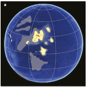
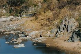
Throwback Thursday: Barberton Greenstone Belt
Between 3.5 and 3.2 Ga years ago, during the Paleoarchean era of the Archean Eon, the Earth didn’t look much like it does today. The atmosphere lacked oxygen meaning there was no protective ozone layer, the oceans, the crust had just formed, oceans were forming, and the first living things (cyanobacteria) were slowly creating free oxygen.
In the midst of all this the Barberton Greenstone Belt was also forming. This belt is found in South Africa east of Pretoria. It is a sequence of mafic to ultramafic lava and metasedimentary rocks (metamorphic rocks that still contain sedimentary structures) that were deposited during the Archean Eon. They are the oldest igneous rocks on earth.
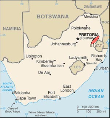
The area underwent two tectonic episodes of terrane accretion, that is two periods of material being added to the tectonic plate at a subduction zone. Imagine it similar to pushing sand in sandbox to form a wall around your sandcastle. This process helped to build new continents throughout geologic time. It is hypothesized that the greenstone belts formed from a passive margin oceanic crust becoming part of a subduction undercut margin.
About 3.1 Ga, a granite batholith was intruded into the belt and partially metamorphosed into gneiss.
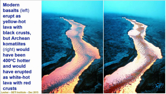
Why is it called the greenstone belt? Well, if you recall from earlier lessons (why is magma formed and what is it made of?) mafic and ultramafic rocks are primarily made of olivine, a green mineral. One of the main types of ultramafic rock found here are komatiites, named for the Komati River that flows through the area. It is a mantle-derived volcanic rock with an extremely high magnesium content and very low silicon, potassium and aluminum content.
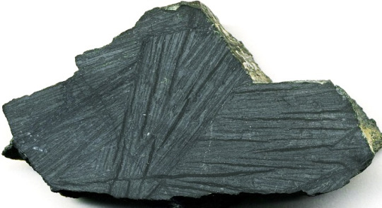
Komatiites are rare because almost all of them formed during the Archean when it is though the mantle was starting to cool. During this time period, the Earth had much higher heat production simply due to all the residual primordial heat of planetary accretion. In fact, eruption temperatures were thought to be up to 1600 degrees C (2912 degrees F). The lava would have flowed with a viscosity close to water.
They are composed of forsterite (magnesium-rich olivine),
calcic and chromian pyroxenes,

anorthite (calcium feldspar)

and chromite.

They often take on spinifex texture meaning the crystals look like spinifex grass, long and blade-like.

Thanks for coming to today’s lesson! Tune in tomorrow to learn more about Patagotitan! Fossilize you later!

42 notes
·
View notes
Text


His Dark Materials
This image shows us “fluvial ridge” landforms and fluvial sediment in the Aeolis region of Mars. The dark-toned material may be windblown sand. Where there is such sand, there is the potential that the bedrock is cleanly-exposed, as opposed to covered with windblown dust. Our goal is to examine details of the sedimentary structure, seek better understanding of how this formed.
ID: ESP_075584_1735 date: 10 September 2022 altitude: 267 km
NASA/JPL-Caltech/University of Arizona
71 notes
·
View notes