#weather forecast: -12c
Explore tagged Tumblr posts
Visit Tumblr Blog
Explore Tumblr blogs with no restrictions, modern design and the best experience.
Last Seen Tumblr Blogs


Fun Fact
In 2020, 27% of US Tumblr users had an annual household income of over $100,000.
Text
woe: troj sheds
26 notes
·
View notes
Text
In Finland, there's an emphasis on children's early independence thanks to the safe environment. This is why most first graders walk to school on their own. The idea is that the daily walk builds self-confidence while providing some exercise.
For this reason, driving children to school is uncommon, which is why Helsingin Sanomat is re-publishing an Aamulehti story from Friday highlighting Tampere parents chauffeuring their kids even for distances under one kilometre. The phenomenon appears to be driven by weather conditions.
According to the paper, about a quarter of elementary school students in Tampere's urban areas are driven to school during the winter, even when the distance is just one to three kilometers.
A cold start to the week
January was unusually mild in southern and central parts of Finland. But the weather is taking a colder turn tonight when temperatures could drop to -35 degrees Celsius eastern Finnish Lapland, according to Ilta-Sanomat. But this all depends if skies are clear since cloud cover works as insulation, resulting in warmer temperatures.
Overall, Finland will experience frigid temperatures at the start of this week. Daytime temperatures in southern and central areas are expected to range between -4C and -12C, while northern areas will see even colder conditions, with temperatures dropping to between -11C and -23C.
Milder conditions will take over by midweek. On Wednesday, temperatures in southern Finland and coastal areas are forecast to rise above freezing, while northern regions will see the cold ease to around -10C.
Peak prices
In more weather-related news, Kauppalehti reports that spot electricity prices are shooting up following the weekend's relatively low costs.
A significant price spike is expected at 6pm, making electricity notably more expensive compared to recent rates.
Prices are steadily rising throughout the day on Monday, peaking between 6 and 7pm at nearly 27 cents per kilowatt-hour. Even later in the evening, costs will remain elevated, reaching approximately 14 cents per kilowatt-hour at 11pm, according to Nordic electricity exchange Nord Pool.
1 note
·
View note
Text
So it wasn't a cold morning, but

It was definitely a WET one.
We're going from 12c today, to forecasted snow next week. Weather is certainly all over the place at the moment. -- Older Team Leader helping me with Priority Task just to make sure they're all cleared out on the assumption that we'll be let out early.
At 10.
It was a slow start and by 11 I was already spinning in my chair because I literally had nothing to do but wait for more stuff to come in. -- More on-off with the radio today, whoof. -- ...Absolutely nothing else for me to do, I've even triple-checked the mini-task I don't even really have to do.
So fanfic it is. -- LET OUT EARRRLLLYYYYYY.
0 notes
Text
Ugh, we just dropped from over two weeks of +30C heat to 12C and rain and I'm just immediately ready to go into "wake me in spring" mode. We desperately needed some rain here, but we went from two weeks of no rain and extreme hot weather to a flooding possibility. I got three alert messages on my phone in the last 24h and the weather forecast says it's gonna rain till, like, Monday.
Second day of shitty weather and I'm desperate for sun. Please give it back.
0 notes
Link
Residents cautioned to minimise heat exposure as the mercury in eastern states forecast to reach up to 12C above averageGet our morning and afternoon news emails, free app or daily news podcastAustralians can expect a hit of summer-like weather...
0 notes
Note
As a Californian going to Noah's show next month, I am very nervous about November in Toronto 🥶😂
I'm not going to lie, this ask did give me a bit of a chuckle.
Toronto, like the rest of Canada, is having a fairly warm fall so far. Coming from California, this might not give you too much comfort - current highs this week are around 12C/53F, and the long range forecast is for 5C/41F, but believe me when I tell you that it could be much worse!
The key to staying warm is layers! I would recommend planning for three layers - an inner layer against your skin, a sweater (wool or fleece if you have it) and an outer shell to break the wind. You'll also want gloves and a toque and/or scarf. I also highly recommend packing more pairs of socks than you might think you'll need - if you step in a puddle or if they get sweaty, your feet will get cold. And if your feet are cold, the rest of you will be unhappy.
As long as the weather stays the way it has been, I think we're going to be lucky (cross your fingers) and I wouldn't be shocked to see people out in Toronto wearing sweaters without a coat. If you're not used to the cold, you might want to plan for something a little warmer. But no need to break out the parkas just yet!
#houdini talks winter?#this is an all purpose fashion adjacent blog#I'm canadian we can talk about the weather for hours
10 notes
·
View notes
Text
Aight, I’m down to 10 drafts (some are plotting asks!!) so I’m gonna head in for the night.
Hopefully I can get more sleep tonight than in previous nights, so even if I still can’t work tomorrow, I can at least clear my drafts (or get close).
I also need to do some interest checks and I’m saying that to remind myself to do it tomorrow.
The weather forecast is snow/ice and getting down to 9F/-12C. Brrrr!! (I’ll be fine, I have socks and a fireplace. And lots of organic lemon, orange, and beet juice.)
#.// hope perches in the soul (ooc)#.// apropos of nothing have a personal tale#I live in the american south and we're just not equipped for those temps anymore#I don't mind the cold though I actually prefer it
3 notes
·
View notes
Text
A fair, dry weekend for the Maritimes followed by a rainy start to May
With a ridge of high pressure building in from the west, just a few clouds and some fog patches are expected Friday night — followed by largely fair weather for the weekend ahead.
We’ve had a few Friday nights in a row now with decent conditions for night sky viewing and Friday night is another. If you wanted to do some star/planet gazing, here are a few things you can spot:
The Waxing Gibbous Moon is 56 per cent illuminated and will be high in the western sky this evening.
Look just to the left of the Moon to spot the star Regulus, part of the constellation Leo.
The planet Venus will set in the northwest near midnight.
Mars and the constellation Gemini follow Venus in the night sky and set a few hours later.
There was a spectacular display of the aurora last weekend, though it’s not expected to repeat this weekend. The latest forecast from the Space Weather Prediction branch of the NOAA only has minor geomagnetic storm conditions forecast for this weekend. The geomagnetic storm that produced the aurora last weekend was rated as severe.
After some morning fog dissipates, a mix of sun and cloud is expected Saturday. Most of the cloud will be high and most widespread around western areas of New Brunswick and southwestern areas of Nova Scotia.
High temperatures will reach the low-to-mid teens for many but remain a bit cooler, 8C to 12C, for P.E.I. and eastern areas of Nova Scotia including Cape Breton. The UV index rated 6 or 7, which is high.
The ridge of high pressure breaks down on Sunday allowing for increasing cloudiness from the west. Most high temperatures should still reach the low-to-mid teens though a bit cooler on the coast and in Cape Breton. Wind will be from the south/southeast, sustained 10 to 20 km/h with gusts 20 to 40 km/h. A larger change in the weather arrives Sunday night into Monday morning.
A weather front off of a low-pressure system centred around Ontario and Quebec will bring the Maritimes a round of rain and gusty weather. Rain will start for western New Brunswick and southwestern Nova Scotia Sunday night.
The rest of the Maritimes will see the rain develop Monday morning and afternoon. Rain persists into Monday night but eases to a chance of showers for Tuesday.
A general 10 to 30 mm of rain looks possible out of that system. Local totals exceeding 30 mm may be possible with the chance of that highest around the Bay of Fundy coastline in New Brunswick and the Atlantic coastline of Nova Scotia. This is a needed rain for the region as we are running a deficit when it comes to total precipitation through the months of March and April.
Forecast updates and regional weather conditions on CTV News Atlantic Five, Six, and 11:30 PM.
from CTV News - Atlantic https://ift.tt/J7S9ilW
0 notes
Text
Strong winds in store for Toronto on Good Friday, federal weather agency says
Strong winds are in store for Toronto for Good Friday, with Environment Canada forecasting gusts of up to 80 km/h. The federal weather agency has issued a special weather statement for the city with gusts expected throughout the afternoon, before weakening in the evening.
The windy weather could lead to some damage to tree branches, as well as local power outages. Friday is expected to be mainly cloudy with a high of 12C and a 70 percent chance of showers in the late afternoon.
The rain could change to periods of snow after midnight, with the temperature falling to 1C. Saturday and Sunday will be sunny with a high of 8C, before rain creeps back into the forecast Monday.
0 notes
Text
Friday 8th May 2020
Celebrating VE Day 75 Years On
The Red Arrows over London
11:00am BST Please observe Two Minutes’ Silence and take a moment to read about VE Day 1945.
BBC Link

Pablo Picasso (1881 - 1973) Title:Ronde au Soleil (Sun Circle), 1959
Also celebrating today Sir David Attenborough, the same age as my late mother, whose birthday would have been on Sunday. David is 94 today. Many Happy Returns Sir, stay well.
People must feel that the natural world is important and valuable and beautiful and wonderful and an amazement and a pleasure.

I’m not sure how we’re going to spend the rest of the day and the weekend seeing as I read this in The Metro yesterday:
Britain will go ‘from summer to winter’ in 48 hours, with Friday seeing highs of 25C followed by freezing temperatures and snow falling in May for the first time in 23 years. A ‘Spanish plume’ will grace the skies on May 8th, which marks the 75th anniversary of the end of World War II in Europe. Though VE day celebrations have been cancelled as a result of coronavirus lockdown, Brits can at least enjoy the Bank Holiday from their gardens, with weather maps showing an 800 mile-wide waft of hot air heading over from Spain. However, that won’t last long, with a 1,000 mile-wide mass of Arctic air heading over on Sunday, causing temperatures to plummet virtually overnight. The Met Office forecast highs climbing from 19C today to 25C on Friday, but falling to 14C on Saturday in the north of England and 10-12C on Sunday across the majority of the country.
Yesterday in the garden I spotted a couple of blooms and some berries forming on the Amelanchier, so hopefully that means the Bullfinch will soon be back and feasting.


Cistus aka Rock Rose. We have two varieties of these soft and papery delicate flowers, this Cistus × Dansereaui 'Decumbens' is my favourite, although I’d take issue with that description of low growing. The other is a very vibrant pink. Both have done extremely well in our heavy clay soil and the fact that the flowers only last a day is compensated by how prolific they are.
The larger Hibiscus is now coming into leaf and the little birds are loving that little bit of extra cover. It won’t flower until well into Summer and again is similar in that the flowers don’t last for long, but are plentiful.

I also took this picture yesterday on the Magnolia Grandiflora, something about the sunlight on the beautiful velvet texture took my eye.

I got into conversation on Twitter yesterday all about Blackbird and Song Thrush confusion and about the differences between female and juvenile Blackbirds, Sometimes it’s so hard to tell. It’s fine looking at the adult male as there’s no mistaking them - either by their song and calls or their distinctive plumage, golden beak and eye ring. Here are a few of our residents.

Blackbirds a type of Thrush, which explains the similarities of their singing voices.

Handsome handsome Mr B

And beauteous Mrs B

The male will typically find a good perch from which to serenade the garden.
I love it when Mr & Mrs Blackbird raise a family. I can watch the little ones for ages, they hop along in a row sometimes and then stay stock still. It reminds me so much of this children’s game Grandma’s Footsteps

Mrs B likes the brown pot for a spruce up and so do the youth

Young Blackbirds and Posing Blackbirds. Always a pleasure. In all cases note the golden eye ring.


PORCH NEST BOX WATCH:
We’ve seen no activity and it doesn’t seem that Tracey is around. Keeping watch and hope. TBC
Side Wall Nest Box Watch: Very busy House Sparrows
Outside links in bold type are not affiliated with this blog
Typos and lapses of grammar are a regrettable oversight
0 notes
Text
Weather: Stormy Saturday - sub-zero temperatures and huge waves expected
New Post has been published on https://diary.nz/weather-stormy-saturday-sub-zero-temperatures-and-huge-waves-expected/
Weather: Stormy Saturday - sub-zero temperatures and huge waves expected

A cold blast of air from the Antarctic is bringing sub-zero temperatures and snow down to sea level in some parts of New Zealand.
Huge waves of up to eight metres are also forecast for the west coasts of both the North and South Islands this weekend.
Boaties and anyone keen on fishing from the rocks are being told to stay home until at least Tuesday because conditions are too dangerous.
“For the first time in a long time we’ve got good southerlies over the country, bringing cold temperatures from the South Pole,” said Metservice forecaster Tom Adams.
“They are already bringing cold temperatures and it will stay cold for a couple of days,” he said.
Mt Cook fell to -3C last night, Blenheim was -1C and Waiuoru in the central North Island was 1C. Nowhere got out of single digit temperatures.
But windy conditions have prevented it getting any colder. When skies clear tomorrow evening, temperatures will fall even further.
The coldest spot will be Alexandra, where the thermostat is likely to drop to -6C in the evening. Wanaka will be -5C and Queenstown -4C.
“Those places are a bit more sheltered from the south-westerly winds, not being on the coast, so it’s going to be pretty cold. Alexandra is only looking at 4C as a daytime maximum,” Adams said.
Southland and Otago farmers should be wary of the “brutal wind chill” that could prove dangerous to newborn lambs and calves by pushing localised temperatures well below zero, WeatherWatch head analyst Philip Duncan said.
A couple of fronts would bring snow showers over the next two days. Metservice’s severe weather outlook warns of likely snow for the central North Island and the north-west and far south of the South Island. Snow could get down to sea level in parts of Southland tomorrow.
“The snow will be good for skifields in the Southern Lakes, and Mt Ruapehu,” Adams said, though he warned that there was a risk of gales for the bottom of the South Island on Monday.
A “big pulse of swell” will produce waves up to eight metres on the West Coast of the South Island and the West Coast of the North Island south of Kaipara Harbour. Further north, swells would be around six metres.
Our high-resolution wave model (2 km) shows the largest waves stay offshore.
Still, big waves will impact the west coast of both islands over the next 36 hours. And with King Tides this weekend, there’s a risk for ‘overtopping’ in localised areas. pic.twitter.com/dKPfEvVNPA
— NIWA Weather (@NiwaWeather) August 1, 2019
Metservice is also warning of severe southwest gales for parts of Southland, Clutha and Dunedin on Monday and early Tuesday.
TODAY’S WEATHER: Whangarei A few showers clearing, then cloudy periods. Gusty southwesterlies easing evening. High: 15C Low: 9C Auckland Showers easing through the morning. Strong southwesterlies, gale gusting 80 km/h in exposed places, easing evening. High: 14C Low: 10C Tauranga Morning cloud and chance shower, then fine. Gusty westerlies. High: 14C Low: 9C Hamilton Showers easing morning with afternoon fine breaks developing, but return in the evening. Gusty southwesterlies easing afternoon. High: 13C Low: 8C Taupo Cloudy periods. Few showers easing morning. Strong, gusty westerlies easing afternoon. High: 11C Low: 7C Whanganui Showers clearing from late morning. Strong, gusty westerlies, easing afternoon. High:14C Low: 9C Wellington Brief morning shower, then fine. Strong southerlies, turning strong northwesterly afternoon. High: 12C Low: 8C Christchurch Early showers, with gale southwesterlies and snow to 700m for Banks Peninsula, clearing morning to fine with northerlies. Rain again at night. High: 13C Low: 0C Dunedin Early showers clearing as winds turn northwesterly. Evening rain with a strong southwest change, and snow lowering to 500 metres. High: 12C Low: 3C Queenstown Becoming fine morning with westerlies. A period of rain from late afternoon, turning to one or two snow showers with southerlies evening. High: 10C Low: -4C
Source link
0 notes
Text
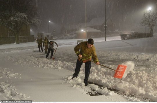
Ice warnings as snow disrupts weekend
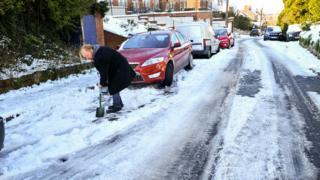
Image copyright PA
Image caption A man clears snow in a street in Westbury, Wiltshire, on Saturday morning
Weather warnings for ice have been issued for Saturday afternoon and evening in parts of England as wintry conditions continue to affect the UK.
The Met Office is advising care as snow is expected to melt during the day and freeze as temperatures drop.
Eastern and southern England are braced for their coldest night of the winter, with -12C (10F) forecast, while parts of Scotland could see similar lows.
The freezing weather has disrupted travel and sports events.
A number of football matches, in League One and League Two and the Scottish League One and Two, have been postponed, and some roads remain closed.
Thames Valley Police say they rescued an eight-week-old baby from a vehicle which came off a road in icy conditions in Bracknell, Berkshire, on Friday night, and ended up in a ditch.

Image copyright Thames Valley Police
Image caption Officers rescued a baby from this vehicle in Bracknell after it came off an icy stretch of road
Meanwhile, a woman who went to the aid of a dog after it fell into a frozen river in Haddington, East Lothian, has been rescued by emergency services. She was helped off the ice on the River Tyne but the dog could not be saved.
Kent County Council said they had 18 tree surgeons working to clear the A2045 in Walderslade, where a number of trees were brought down by the weight of the snow and drivers were left trapped in their cars overnight. The road is not expected to reopen until Sunday afternoon.
In Pictures: Some of the most striking images of snowfall
Snow closes road as 100 trees come down
Lorries struggle as cold spell continues in Scotland
The Met Office has issued a yellow weather warning for ice across southern and eastern parts of the UK from 16:00 GMT on Saturday to 11:00 on Sunday morning.
It said that while most areas would be dry, temperatures are expected to fall rapidly after dark with wet surfaces refreezing, meaning an increased likelihood of accidents due to icy surfaces.
The cold weather is forecast to continue in parts of central and southern Scotland where a yellow warning has been issued for between midnight and 14:00 GMT on Monday, with the snow and ice expected to hit the morning commute.

Parts of southern England saw 19cm (7.5in) of snow on Friday, with motorists stuck in vehicles overnight and falling trees blocking train lines.
Highways England said police had worked until 02:00 GMT on Saturday to free vehicles from the M3 near Basingstoke.
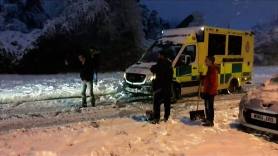
Media playback is unsupported on your device
Media captionAmbulance rescued on snowy road in Basingstoke
Up to 1,500 people were without left power in the Basingstoke area of Hampshire – but power was restored around lunchtime.
Scottish and Southern Electricity Networks said its engineers had struggled to reach “fault locations… with snowdrifts of up to 5ft in places”.
Bristol Airport – which closed its runway on Friday – saw some delays on Saturday morning because of the de-icing of runways but a full flight schedule was in operation.
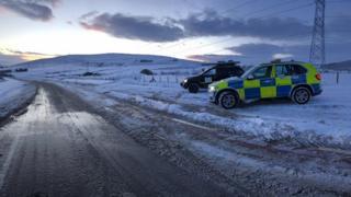
Image copyright Police Scotland
Image caption The A96 was open on Saturday morning but police said conditions were treacherous

Image copyright PA
Image caption The village of Rowde and surrounding fields in Wiltshire remains covered in a blanket of snow
Image copyright PA
Image caption Cars were left abandoned at the side of roads near Maidstone in Kent
The A96 in the north east of Scotland was blocked overnight after a lorry jackknifed just south of Keith in Moray on Friday afternoon.
Police said three other lorries got into difficulties further south on the same road on Saturday.
Sports fixtures postponed
Six English Football League matches have been postponed because of snow and freezing conditions, including one League One match, Accrington v Blackpool, and five League Two games.
Five Scottish League One and Two matches have also been called off.

Image copyright Getty Images
Image caption Ground staff make sure Scotland’s Six Nations clash with Italy can go ahead – but a host of sporting fixtures have been cancelled
Meanwhile, skiers and snowboarders have been warned against taking to the streets in urban areas.
Daniel Loots, from the Ski Club of Great Britain, said he advised against skiing or snowboarding on the street or pavement as “although it looks fun it’s pretty dangerous”.
His advice was to stick to the countryside and parks.
Rough sleeping: What is being done about homelessness?
How do I efficiently de-ice my car?
In pictures: Snow dogs of England
Media playback is unsupported on your device
Media captionIs more snow and ice on the way? Check out the latest forecast
What’s the weekend forecast?
BBC weather presenter Mel Coles said there was lying snow in many parts of the UK, and the ice risk remained high through Saturday night and into Sunday morning.
Snow showers would ease in the later part of the day, but the weather is expected to turn very cold overnight, with experts predicting “the coldest night of the winter so far” in England, where temperatures in areas where snow has fallen could dip to -12C.
Temperatures even in cities such as London and Birmingham could fall to a “very unusual” -4 or -5, with -12 also expected over the snowfields in Scotland, such as Aboyne and Braemar.
However, Sunday will mark “a day of change” with milder air pushing in bringing heavy rain and some windy conditions in the coming week.
Temperatures fell to their lowest level this winter in the early hours of Friday, with Braemar, Aberdeenshire, dropping to -15.4C (6F).
This is the lowest in the UK since 2012 – when temperatures fell to -15.6C in Holbeach, Lincolnshire.

You must enable JavaScript to view this content.
Compare the temperature where you are with more than 50 cities around the world, including some of the hottest and coldest inhabited places. Enter your location or postcode in the search box to see your result.
Find a location


Your location
°C
°C
°C
@-moz-keyframes gel-spin { 0% { -moz-transform: rotate(0deg); } 100% { -moz-transform: rotate(360deg); } } @-webkit-keyframes gel-spin { 0% { -webkit-transform: rotate(0deg); } 100% { -webkit-transform: rotate(360deg); } } @-ms-keyframes gel-spin { 0% { -ms-transform: rotate(0deg); } 100% { -ms-transform: rotate(360deg); } } @keyframes gel-spin { 0% { transform: rotate(0deg); } 100% { transform: rotate(360deg); } } .bbc-news-visual-journalism-loading-spinner { display: block; margin: 8px auto; width: 32px; height: 32px; max-width: 32px; fill: #323232; -webkit-animation-name: gel-spin; -webkit-animation-duration: 1s; -webkit-animation-iteration-count: infinite; -webkit-animation-timing-function: linear; -moz-animation-name: gel-spin; -moz-animation-duration: 1s; -moz-animation-iteration-count: infinite; -moz-animation-timing-function: linear; animation-name: gel-spin; animation-duration: 1s; animation-iteration-count: infinite; animation-timing-function: linear; } @font-face { font-family: 'ReithSans'; src: url('//static.bbci.co.uk/frameworks/barlesque/3.21.31/orb/4/font/BBCReithSans_W_Rg.woff2') format('woff2'), url('//static.bbci.co.uk/frameworks/barlesque/3.21.31/orb/4/font/BBCReithSans_W_Rg.woff') format('woff'); } @font-face { font-family: 'ReithSans'; src: url('//static.bbci.co.uk/frameworks/barlesque/3.21.31/orb/4/font/BBCReithSans_W_Bd.woff2') format('woff2'), url('//static.bbci.co.uk/frameworks/barlesque/3.21.31/orb/4/font/BBCReithSans_W_Bd.woff') format('woff'); font-weight: bold; } html .bbc-news-vj-wrapper { font-family: ReithSans, Helmet, Freesans, Helvetica, Arial, sans-serif; }
This temperature comparison tool uses three hourly forecast figures. For more detailed hourly UK forecasts go to BBC Weather.
If you can’t see the calculator, tap here.
Original Article : HERE ; This post was curated & posted using : RealSpecific
Ice warnings as snow disrupts weekend was originally posted by News Now
0 notes
Text
UK weather: Britons wake up to snow with nearly a FOOT more set to fall today
UK weather: Britons wake up to snow with nearly a FOOT more set to fall today
Parts of northern England and Scotland woke up to heavy snowfall this morning with more wintry weather now forecast for the weekend and into next week as temperatures plunge as low as -12C (10F). An amber weather warning covering parts of eastern Scotland, County Durham and Northumberland is in force until the mid-morning today, amid fears of a second ‘Beast from the East’ this winter in the…
View On WordPress
0 notes
Photo

UK weather forecast – Brits braced for coldest night of winter TONIGHT as -12C ice plunge leaves flights CANCELLED and snow blanket country Read Here
0 notes
Text
Your weather: Snow, storms and massive waves to batter New Zealand
New Post has been published on https://diary.nz/your-weather-snow-storms-and-massive-waves-to-batter-new-zealand/
Your weather: Snow, storms and massive waves to batter New Zealand
A Southern Ocean storm crashing into New Zealand is set to unleash fresh snow, dangerous waves, storms, gales and bitterly low temperatures this weekend.
Boaties and anyone keen on fishing from the rocks are being told to stay home until at least Tuesday because conditions are too dangerous.
Massive 15m waves smashed the South Island’s Fiordland yesterday and heavy waves up to 9m are expected to hit close to Auckland today in the Waikato and Northland, forecaster WeatherWatch says.
Heavy snowfalls are also expected to continue today after falls in the North Island’s central plateau and Southern Alps closed multiple roads yesterday.
Sunday and Monday will bring the coldest temperatures across the country. Queenstown and Invercargill can expect snow as the overnight temperature plummets to 0C and below.
Auckland is set to be hit by blustery gales up to 80km/h today as it heads for a high of 14C today and sporadic showers, before the mercury drops to 12C on Monday.
WeatherWatch expects the Bay of Islands, eastern Coromandel Peninsula and Gisborne to be the most settled regions this weekend. Tauranga and Gisborne are mostly fine today with highs of 14C.
But elsewhere, most of the country will be hit by at least sporadic rain and strong winds.
youtube
New Plymouth residents can expect wind gusts up to 90km/h and morning rain, while Wellington can expect a fine afternoon after morning showers, forecaster MetService says.
A stormy front moving up from the South Island could bring thunderstorms with hail and 90km/h wind gusts to the Wairarapa.
In the South Island, Christchurch is headed for a high of 13C as morning showers clear and snow falls to 700m in Banks Peninsula.
Overnight, temperatures in the city could then plummet to -1C over the next two days.
Southland and Otago farmers should be wary of the “brutal wind chill” that could prove dangerous to newborn lambs and calves by pushing localised temperatures well below zero, WeatherWatch head analyst Philip Duncan said.
Motorists are being advised to be careful on alpine roads due to heavy snowfalls, while boaties and rock fishers are being told to stay at home due to dangerous waves. Photo / Yvonne O’Hara
Queenstown can expect snow today and tomorrow and overnight lows of -3C and -5C.
Invercargill is headed for a freezing 5C tomorrow with snow and sleety rain, while Dunedin can expect a top of 7C tomorrow with snow to 300m.
Heavy rain and strong wind watches in Buller, Marlborough and Nelson were set to end early this morning, as was a strong wind watch for Hawke’s Bay south of Hastings and the Wairarapa.
But MetService warned more warnings were possible over the weekend as “the theme for the next five or six days is cold, windy and unsettled”.
Saturday’s weather outlook
Whangārei:
A few showers clearing, then cloudy periods. Gusty southwesterlies easing evening. High 15C, Low 9C
Auckland: Showers easing morning. Strong southwesterlies, gale gusting 80 km/h in exposed places, easing evening. High 14C, Low 10C
Hamilton: Showers easing morning with afternoon fine breaks developing, but returns in the evening. Gusty southwesterlies. High 13C, Low 8C
Tauranga: Morning cloud and chance shower, then fine. Gusty westerlies. High 14C, Low 9C
Napier: Chance early shower, then becoming fine. Strong and gusty westerlies, tending southwest for a time. High 15C, Low 6C
New Plymouth: Often cloudy. Showers becoming isolated in the afternoon. Strong westerlies, gusting 90 in exposed places at first. High 14C, Low 9C
Wellington: Brief morning shower, otherwise fine. High 12C, Low 8C
Nelson: Becoming fine early. Evening cloud. Strong southwesterlies easing. High 14C, Low 5C
Christchurch: Early showers, with gale southwesterlies and snow to 700m for Banks Peninsula, clearing morning to fine. High 13C, Low 3C
Queenstown: Becoming fine morning with westerlies. A period of rain from late afternoon, turning to one or two snow flurries. High 10C, Low -3C
Dunedin: Early showers clearing as winds turn northwesterly. Evening rain with a strong southwest change, snow lowering to 500m. High 12C, Low 3C
Invercargill: Early rain clearing and becoming fine. Easterlies. High 13C, Low 3C
Source link
0 notes
Text
Clocks go forward tomorrow night- but don’t ditch your winter woollies
Brrrrrrritish Summer Time: The clocks spring forward tonight…but don’t be fooled into ditching your winter woollies just yet as cold front comes in
Clocks will go forward for summer- but parts of Britain could see snow showers
The mild weather will be replaced by rain, gales and overnight frosts next week
The clocks will go forward on Sunday morning at 1am to British Summer Time
By Richard Marsden for the Daily Mail
Published: 21:14 EDT, 29 March 2019 | Updated: 22:09 EDT, 29 March 2019
The sun’s arrived just in time for the clocks to spring forward to British Summer Time – but don’t be fooled into packing away your winter woollies just yet.
The mild conditions will be replaced by rain, gales, overnight frosts and even snow showers over the coming days.
High pressure is expected to bring balmy temperatures of up to 19C (66F) in southern England today, but a much chillier picture is forecast for the week ahead.
People played volleyball on Boscombe beach in Dorset yesterday as they enjoyed the mild weather. However, a much chillier picture is forecast for the week ahead
Daytime temperatures are set to plummet to between 8C and 9C (46-48F) in many areas, with successive weather fronts bringing in wet and windy weather.
Richard Miles, from the Met Office, said: ‘It is due to be much more unsettled over the coming week.
There will be showery conditions everywhere at some point and it is due to feel quite cold at night, with overnight temperatures falling to -2C (28F) or -3C (27F) by Tuesday.
‘On Tuesday night into Wednesday, there could be gales near the west coast with winds of at least 30mph.
‘By the middle of the week, temperatures could be cold enough for wintry showers of sleet or snow to feed in off the North Sea.’
People punt along the River Cam in Cambridge yesterday in glorious spring weather. The temperature dip is due to begin today when a weather front sinks south, bringing patchy rain south to central England
The temperature dip is due to begin today when a weather front sinks south, bringing patchy rain south to central England.
Temperatures may struggle to exceed 11-12C (52-54F). Tomorrow will be dry but colder and cloudy, while Monday will start ‘cold, frosty and bright’.
The clocks will go forward on Sunday morning at 1am.
Advertisement
Share or comment on this article:
The post Clocks go forward tomorrow night- but don’t ditch your winter woollies appeared first on Gyrlversion.
from WordPress https://www.gyrlversion.net/clocks-go-forward-tomorrow-night-but-dont-ditch-your-winter-woollies/
0 notes