
Don't wanna be here? Send us removal request.
Statistics
We looked inside some of the posts by angelikacbr-blog and here's what we found interesting.
Average Info
Notes Per Post
1
Likes Per Post
1
Reblog Per Post
0
Reply Per Post
0
Number of Posts By Type
Text
1
Last Seen Tumblr Blogs


Fun Fact
The Tumblr app for Google Glass was released on May 16, 2013.
Text
An ‘E’ to Combat ‘E’ffects of Disasters

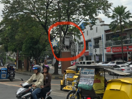
Marikina is a “lush valley bounded by mountain ranges and sliced by a river” (Marikina City Government, n.d.). With considerations to its geographical location, Marikina is known to be a flood-prone municipality especially during occurrence of typhoons and monsoon (habagat). It also lies along the West Valley Fault (Malicdem, 2017) which makes it susceptible and at risk of earthquakes. These two major and primary hazards – flood and earthquake – posed by Marikina’s geographical features (physical vulnerabilities) are also identified risks in Barangay Marikina Heights, one of the 16 barangays in Marikina and occupies a land area of approximately 2.06 square kilometers (Marikina City Government, n.d.). These natural and/or manmade hazards may also serve as antecedent of secondary hazards such as electric shock and fire due to electric wirings especially in malls and residential areas. Although people are often informed about the abovementioned risks, there are also other hazards in the barangay that are considered minor but may nonetheless possibly constitute a disaster. To name a few are the (a) cemented decorations and/or figures above a post situated along the road and (b) an unfinished structure with exposed steel bars especially since it is located along a road with uneven elevations or slope (these are respectively shown in the pictures below).


Although there are several hazards identified, there are also capacities and strengths assessed. Perhaps, one of the best practices is the regulated use of plastic products especially in business. Capabilities also include existence of their barangay-based Disaster Risk Reduction and Management Council and Disaster Risk Reduction and Management Plan with primary foci. First is the prevention and mitigation activities which include capacity-building through spreading awareness to the rest of the community as well as regular fire drills and earthquake drills, allowing all members to partake in the endeavor. The barangay also works in coordination with nearby barangays in monitoring the situation of the Marikina River in times of heavy and continuous / persistent rains. As part of preventive measures, regular cleaning of canals and drainage is also conducted to avoid clogging that could intensify possible floods. They also have a hotline number both for the barangay and for the entire municipality. A rescue team was also assembled and necessary equipment such as aerial baskets, land trucks, mobile and motorcycle patrols, generators, stretchers, first aid kits, and medical supplies were prepared in case of emergencies. The council also secured evacuation centers and facilities including the open ground located at East Drive Champagnat St. Intersection, covered courts in schools, and Red Cross facility near Barangay Fortune. Second foci are the measures observed during the event of the disaster. These measures include but are not limited to roving of rescue teams such as Bantay Bayan and the Barangay Police Auxiliary Team. The Barangay Hall also serves as a first aid center before people are transferred to the evacuation center. Third is the post-disaster activities such as distribution of relief goods, and assessment of the community for possible secondary hazards.
From my viewpoint, the community is confronted with a spectrum of hazards, may it be environmental or anthropogenic, and ranging from negligible to pressing. Environmental hazards in the community include flooding and earthquake. Anthropogenic also includes flooding alongside fire and electric hazards to name a few. Based on my inference from the interview, the barangay officials and councils work hand in hand with the rest of the community to mitigate risks and/or minimize its impacts and implications to lives and properties. The local government is addressing these issues well, and that is primarily through EMPOWERMENT of the council in leading the disaster risk reduction and readiness and EMPOWERMENT of the rest of the community through information-sharing and encouraging active participation. However, although it is with no doubt that major events like earthquake and flooding are pressing issues that the community must prepare for, I think that the local government can also invest more in assessing minor risks such as the ones I observed during the walk and mentioned above (cemented figures above a post situated along the road and an unfinished structure with exposed steel bars). It is through thorough risk identification, assessment, and evaluation, while taking into accounts even the negligible risks that we are truly able to come up with a plan that safeguards the lives and well-being of the community.
In the grander scheme of things, which is disaster at a national level, similar concept as that of the barangay is applicable, only that it has a wider scope especially in terms of population. The Philippines is located at the Pacific Ring of Fire which makes it vulnerable to natural disasters such as frequent cyclones, earthquakes, and volcanic hazards (UNDP, n.d.). Aside from hazards posed by its geographical features, there are also societal and social vulnerabilities that must be addressed. These include but are not limited to poverty, inadequate education, and stigma on gender and social status.
Considering these thoughts supplemented my realizations during the walk. It is important to note that if this state of being CRITICAL helps, it will only help the community if the community itself is CRITICAL. These hazards pose risk to the community, and it takes the entire community to combat these hazards because first, hazards does not only affect a person or two – hazards affect majority, if not the entirety of the community. We must be CRITICAL so as to understand these hazards, risks, exposure and vulnerabilities, how these lead to disaster and its impacts in order to formulate ways and means of minimizing our susceptibility. And we must share to others how to be really CRITICAL through sharing information and encouraging others to be active in participating seminars especially about how to prepare and what to do during disasters as well as in first aid trainings.
Among the concrete solutions I can do in addressing vulnerabilities is through organizing a symposium about Disaster Risk Reduction and Readiness, particularly about risk assessment and mitigation. This is because as a student, I am lucky enough to have access to education. And it is in sharing knowledge that we are able to truly EMPOWER others. And that EMPOWERMENT could equip the people and the entire community.
DOCUMENTATIONS:


REFERENCES:
[1] About the Philippines. (n.d.). Retrieved December 17, 2019, from https://www.ph.undp.org/content/philippines/en/home/countryinfo.html.
[2] Malicdem, E. (2017, August 25). LIST: 99 Villages and Subdivisions Traversed by the Valley Fault System. Retrieved December 17, 2019, from https://www.s1expeditions.com/2017/08/221-villages-subdivisions-valley-fault.html.
[3]Marikina City: The Shoe Capital of the Philippines. (n.d.). Retrieved December 17, 2019, from https://www.marikina.gov.ph/.
1 note
·
View note