
A strong, dynamic and innovative department that prides itself as a consistent provider of high quality scholarly activity, programs and courses.
Don't wanna be here? Send us removal request.
Statistics
We looked inside some of the posts by lauriergeogenv and here's what we found interesting.
Average Info
Notes Per Post
33
Likes Per Post
17
Reblog Per Post
16
Reply Per Post
0
Time Between Posts
13 hours
Number of Posts By Type
Text
17
Last Seen Tumblr Blogs


Fun Fact
Tumblr has a low social media market share in South America.
Text

Interested in issues of human rights and citizenship? Laurier G&ES prof Margaret Walton-Roberts has co-edited a new book on the subject.
Check out her blog posting about the book, and the example of 'Chaos in the Caribbean’
http://pennpress.typepad.com/pennpresslog/2015/07/chaos-in-the-caribbean-the-dominican-republics-resolution-16813-and-the-slipperiness-of-citizenship.html
2 notes
·
View notes
Text
More pictures from ACU trip hosted by GES faculty.
Thermal mapping with the department drone


^ Above: A tour of the Centre for Cold Regions and Water Science

^ Above: Graduate student research talks

^ Above: Thermal mapping with the department drone

^ Above: Smartphone-based citizen science data collection

^ Above: An inspiring talk by Aboriginal Scholar-in-Residence Darren Thomas
Our faculty hosted international students from Association of Commonweatlth Universities. They came from Africa, Asia, the Caribbean, and Europe.
The academic goal was to expose the students (all of whom are at the graduate level) to ways of collecting and interpreting environmental data.
A great time had by all.
2 notes
·
View notes
Text
#LaurierGeogEnv hosted international students from ACU
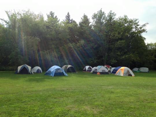
~ Above: “The tent city prepared for the international students before their arrival”.
G&ES profs and grad students took 35 visiting international students camping at Laurel Creek CA last night. They were taken canoeing, had a campfire, and were given some insights into collecting environmental data. Here's what the tent city looks like before the students arrived.

~ Above: “ The students from ACU have arrived and are learning how to collect environmental data using a drone”.
#acu#lauriergeogenv#tentcity#international#laurelcreek#robertson#rmcleman#McLeman#IanMartin#ThomasTiidus
2 notes
·
View notes
Text
Fall 2015 course: Northern Resources and Environments (GG/ES494)
This course:
- is an examination of northern ecosystems and environments in the context of resources management - is started with a "How would you describe or characterise the north?" discussion (interesting to see how discussion changes or doesn't change) - has short debates on hot topics in the north - has lots of good audiovisual resources on the north - has a primary focus on Canada and Alaska


~ Above: “Photos are from Dr. Scott Slocombe of areas in the north that he worked”.
Students typically enjoy learning about the north, and are surprised by many things they learn (both things they expected and things they didn't).
Contact Dr. Scott Slocombe <[email protected]> for more information.
Prerequisites are ES101/ES102 OR ES290/GG290
2 notes
·
View notes
Text
Coming this winter: Catchment and Global Biogeochemistry (GG387)
This course has been changed from Fall2015 to Winter2016. NEW course.

2 notes
·
View notes
Text
Shelf cloud that spawned three tornadoes

The photo was taken at Sauble Beach, but the tornadoes were at Marsville, Teviotdale and at Lebanon, near Conestogo Lake.
Captured by Dr. Mary-Louise Byrne on August 2nd, 2015
1 note
·
View note
Text
3rd-year G&ES field camp
The destination and dates for this fall’s 3rd-year G&ES field camp have been announced: Thursday, Oct 1. to Sunday, Oct. 4, at Pinery Provincial Park, on Lake Huron. This is the second year Laurier G&ES students have done field research at Pinery, and it promises to be as awesome as last year. Research this year topics will include: - mapping with unmanned aerial vehicles (drones) - impacts of eco-passages and culverts - impacts of natural areas on human health - tornado impacts and restoration - reclamation of closed camping areas - managing park visitor complaints and conflicts - sand dune maintenance and restoration - pine tree inventory and restoration - cumulative impacts of controlled burning

~ Above: “Pinery Provincial Park”
Mark your calendars!
2 notes
·
View notes
Text
An emerging leader transforming parks across Canada is among us
Shailyn Drukis - an emerging leader transforming parks across Canada is among us!
She was among a group of 16 young Canadians that were an active and leading role at the International Union for Conservation of Nature's World Parks Congress in November, 2014.

~ Above: “ International Union for Conservation of Nature's World Parks Congress in November, 2014″.
With help from Parks Canada, Shailyn shared her experiences, perspectives, knowledge, skills, technologies, and ideas in innovative and creative ways.

~ Above: “Shailyn Drukis”
To learn more about what Shailyn learned/is currently doing, as well as and other young inspiring leaders check out the article.
http://thestarfish.ca/home/2015/7/check-out-6-emerging-leaders-transforming-parks-across-canada
2 notes
·
View notes
Text
Fall graduate course: Paleolimnology (GG648):

~ Above: “Growler Lake in the Muskoka region”.
Paleolimnology is the multi-disciplinary science of lake mud – the physical, chemical and biological analyses used to reconstruct lake environmental history.
The highlight of this course will be a field trip to Growler Lake in the Muskoka region (as seen in the photos) to obtain a lake sediment core that the class will analyze and interpret results. The results will be presented to the local cottage owners at the end of the term. The local cottage owners are keenly committed to ensuring their lake remains pristine and that the project will develop a long-term history of Growler Lake that will assist them in achieving their management goals.
The class is Mondays 9:30am - 12:30pm in 2E7. There are a few spots remaining.
Paleolimnology is taught by Dr. Brent Wolfe and co-taught with his colleague Roland Hall (Biology, University of Waterloo). For additional information feel free to contact Dr. Brent Wolfe at [email protected] .

~ Above: “Growler Lake in the Muskoka region”.
2 notes
·
View notes
Text
GL101/GL102 example:

Check out these cool rock formations in Waterton Lakes National Park. Interested in learning how things like this happen? Take a geology course with us this year.
2 notes
·
View notes
Text
Research bio: Juan Felipe Gómez (Graduate thesis)
Juan's research studies variables influencing: - The dune and coastal evolution in Isla Salamanca National Park, Colombia (ISNP) -The biosphere reserve - The Ramsar (wetland) site located in the Caribbean coast of Colombia. The variables include: - Climate - Bathymetry (study of underwater depth of lake or ocean floors) - Vegetation Juan uses: - Aerial photographs - Satellite image - Field work It was found that at least since the early 1950s, the park has been affected by eroding trends along most of the shoreline. As a result, most modern dunes are located close to the coastline, forming scarped dunes regularly affected by storm wave-action. The only exception to this erosive trend is located on the west extreme of the study area, a sector that is a sediment sink for sediment transported by the east to west littoral drift. There, small dunes (also termed embryo dunes) are constantly forming and evolving.

~ Above: “The Ramsar (wetland) site located in the Caribbean coast of Colombia”.
It is indicated that different vegetation associations are found on dunes next to erosive (i.e., scarped dunes) and accretive (i.e., embryo dunes) shorelines. On erosive shorelines: - The frequent surface disturbance limits the establishment of early successional species. As a consequence of the continuous shoreline displacement in these areas of coastal retreat, late successional vegetation that normally grows at a distance from marine influences is progressively becoming closer to the shoreline. In the accretive shorelines of the west area: - Abundant sediment supply restricts vegetation diversity to just a few species adapted to thrive under windy conditions and sand burial, resulting in low vegetation diversity. Given enough time, under the current conditions embryo dunes may evolve to foredunes and parabolic dunes with the associated development of late successional communities. The findings of this research contribute to understanding the interlink between coastal morphodynamic, landscape, and different vegetation associations, thereby providing useful data to support sound decisions for the management of the coastal zone in ISNP. Good work Juan!
1 note
·
View note
Text
Faculty profile: Dr. Brent Wolfe

“My name is Dr. Brent Wolfe and I am a professor in Geography and Environmental Studies. My research interests focus on understanding the consequences of climate change, resource development and other stressors on large, northern lake-rich landscapes. This mid-summer post comes during the midst of a busy field season for my research group. This summer we launched a new project in the Peace-Athabasca Delta (northern Alberta), a place we have worked for many years. The project is supported by provincial and federal agencies, and industry. We are assessing the spatial distribution of contaminants and toxicity in lakes of the delta, their sources and pathways. My primary research role is to use water isotope tracers to determine the relative influence of hydrological processes on the lake water balances. This information will be critical to the interpretation of the contaminant and toxicity data. Given all of the concerns related to environmental consequences of oil sands development upstream, we think the world will be interested in our findings.

~ Above: “ This photo is of Casey Remmer (undergraduate student, Biology, University of Waterloo) taking a sample of river water for chemical analyses from the helicopter float in the Peace-Athabasca Delta (26 May 2015)”. This summer also marks the 6th year that we have been working in northern Manitoba in Wapusk National Park, furthering our knowledge of the effects of climate change and disturbance by Lesser Snow Goose populations on the many shallow lakes and ponds in the park. This summer, my graduate students are training Parks Canada staff in our sampling techniques so they will be able to monitor trends and status of aquatic conditions in the park. Finally, at the end of the summer, we will launch a new project in the Marian Lake watershed (MWT). Working closely with the local community, we will obtain lake sediment cores to develop baseline concentrations of metals, in advance of a proposed cobalt-gold-bismuth-copper mine. The research results will enhance a community-based aquatic effects monitoring program. In the fall, I will be teaching two courses: one undergraduate course which is Seminar on Cold Regions (GG481) and one graduate course which is Paleolimnology (GG648). To learn more about my research or about available projects, feel free to contact me at [email protected] "
2 notes
·
View notes
Text
Fall 2015 course: Seminar on Cold Regions (GG481)
GG481 is a physical geography course will be taught by Dr. Brent Wolfe from mainly a research perspective that examines periglacial, permafrost, hydrological and oceanographic processes active in the cold regions ecosystems.
The focus is the Peace-Athabasca Delta, where decades of research have attempted to disentangle the relative roles of natural resource development and climate change on this world-renowned landscape. Some of the research results will surprise you!

~ Above: “Shows the water-rich landscape of the Peace-Athabasca Delta (29 May 2015)”.
Students will be tasked with developing expert knowledge of this landscape and the issues facing it and, ultimately, providing recommendations for Wood Buffalo National Parkhttp://www.pc.gc.ca/eng/pn-np/nt/woodbuffalo/index.aspx to enhance their efforts to safeguard and effectively manage this landscape.

~ Above: “ This photo shows what was formerly ‘Spruce Island Lake’, now ‘Spruce Peninsula Lake’. Lake levels in the Peace-Athabasca Delta are very low this year. (27 May 2015)”.
Dr. Wolfe believes that the course serves as an excellent integrator of much that has been learned during a student’s 4-year experience in our undergraduate program and looks forward to teaching it! As of right now there are still 4 spots left in the course.
The course is offered Tuesdays and Thursdays from 11:30am - 12:50am in BA209 for the Fall 2015 term.
GG281 and GG282 are required.
3 notes
·
View notes
Text
Research bio: Thomas Tiidus
Thomas is a second-year MSc Geomatics student whose research uses camera sensors mounted on Unmanned Aerial Vehicles (UAVs, aka drones) to observe and monitor the health of apple orchards.

~ Above: “Image of Thomas with the UAV used for the research”
The UAV flies three different types of camera sensors over orchards to obtain data, which is then put through computer algorithms to identify information such as which trees may be suffering from lack of water, as well when trees need to be watered.
Types of camera sensors: - a HD digital camera to obtain true colour images and to generate a Digital Elevation Model (DEM) of the orchard. - a Near Infrared (NIR) camera to create a Normalized Vegetation Differential Index (NDVI) to estimate of the biomass of the plants. - a thermal camera to measure plant temperatures.
Understanding precisely when trees need to be watered helps an apple grower conserve water and maximize their fruit yield. Apple growing is a highly competitive industry, and Ontario growers are faced with many challenges, including climatic variability and change. Thomas’s research is the first of its kind in Canada, and promises to teach us more about the potential for using UAVs and camera sensors in Ontario agriculture.
Great work Thomas!
Graduate student of Dr. Robert McLeman
2 notes
·
View notes
Text
Graduate at summer workshop/field school for CoPEH
Lauren Yee is a graduate student working with Dr. Colin Roberton in the Spatial Lab. This past June, she has attended an interesting workshop/field school in Montreal, Quebec for CoPEH Canada (Canadian Community of Practice in Ecosystem approaches to health).
In Montreal, graduate students, professionals and scholars came together to address the issues associated with the St. Lawrence River from a transdisciplinary and EcoHealth approach. Each day was filled with lectures, activities and collaborative work within small groups.
The whole concept of EcoHealth derives from the fact that most problems we face (especially in the realm of geography and environmental science) are extremely complex in nature. An EcoHealth approach attempts to understand or realize these complexities to a problem and address them. From CoPEH Canada’s website: “These approaches also encourage social and gender equity and participation, recognizing that improving health and well being requires sharing and exchange of different kinds of knowledge in order to enhance both integration and action.”
Lauren's thesis is focused on the determinants of wildlife health and disease, and of healthy ecosystems. She asks: what could serve as early indicators of disease to find gaps in existing surveillance data, and where should surveillance take place in Canada? Lauren's thesis relies on GIS, remote sensing, and programming. She is also working on a web-scraping project this summer that will compare alternative sources of information (blogs, mailing lists, local conservation authorities, etc) to more authoritative sources on wildlife health. Lauren's interests made her the perfect candidate for the CoPEH Canada workshop/field school in Montreal.

~ Above: “old port in Montreal”

~ Above: “The boat ride to Lac Pierre. The significance of Lake Saint-Pierre is that Lake Saint-Pierre as its part of the St. Lawrence seaway and has been dredged to accommodate all the fishery and trade traffic. The wave action from all the boat traffic, recreational and leisurely, has eroded significant portions of the shoreline and protected areas. It's an area that has been polluted by effluents from industry as well as municipal waste. . It's also recognized as a nature reserve for migrating waterfowl. It's a very important area for nesting herons. It is prone to natural flooding so many houses are built on "stilts".
Below is a link to a song Lauren made for the course, which requires students to create an artistic representation of what they learned about EcoHealth and how it reflects on their research.
~ SONG --> https://soundcloud.com/laurenyee/nature-vs-industry
Throughout her experience in Montreal, the most meaningful was learning from peers from across the globe, from as far away as Africa and South America, and from elsewhere in Canada, coast to coast. As well as renewed confidence in herself, she came back with new ideas and methods she can use in her research (although she's already missing the culture of Montreal and the connections she made).
Great work Lauren!
#lauriergeogenv#research#workshop#currentstudent#laurenyee#copeh#health#ecosystem#gis#student#thespatiallab#robertson
2 notes
·
View notes
Text
Emergency Routing Services project
Rachel Schaus is a recent Laurier Honours BA graduate in Geography with Geomatics option who has been working on a really cool initiative called the Emergency Routing Services project.
With a collaborative team at Fleming College, Rachel has assisted to create a customized Laurier campus digital basemap that helps first responders (police, fire, ambulance) get to emergency scenes on campus more quickly. The Laurier Special Constables are able to use the custom mapping application to view building layouts and floor plans on mobile tablets, and to track incident locations and identify patterns.

~ Above: “In the group photo of Rachel and the team, Rachel is the on the right with the grey sweater and long blonde hair. The photo also includes other important members on the team: Pam Schaus, the departmental cartographer (most left) and Dr. Mary-Louise Byrne (second left) from the department, as well as Johanna Romero from Physical Resources (in orange to the right of Dr. Byrne)”

~Above: “ The map was generated by the new application that the team developed. It shows the fastest route for emergency responders to get to an incident on the second floor of the Arts Building”.
Rachel's work helps to make Laurier an even safer place to work and study. Great job, Rachel!
#RachelSchaus#geomatics#lauriergeogenv#Fleming College#PamSchaus#MLByrne#Emergency Routing Services project#alumni
2 notes
·
View notes
Text
Young City Growers
Hey Laurier G&ES students. Want to get involved with small scale urban agriculture?
Check out the Young City Growers, a community group that operates commercial vegetable gardens on Laurier's Northdale Waterloo campus. This week they're harvesting salad greens, beets, radishes, kale, and garlic scapes, with tomatoes, peppers, cukes and more soon to come. The produce is sold via CSA subscriptions. If you want to get your hands dirty and learn to grow your own food, connect with them at this link. https://www.facebook.com/pages/Young-City-Growers/477899055580827

~ Above: “photo of their campus gardens”.
2 notes
·
View notes