#Delaware & Hudson
Explore tagged Tumblr posts
Visit Tumblr Blog
Explore Tumblr blogs with no restrictions, modern design and the best experience.
Last Seen Tumblr Blogs


Fun Fact
There were a total of 171.5 billion posts on Tumblr in 2019.
Text
152 notes
·
View notes
Text


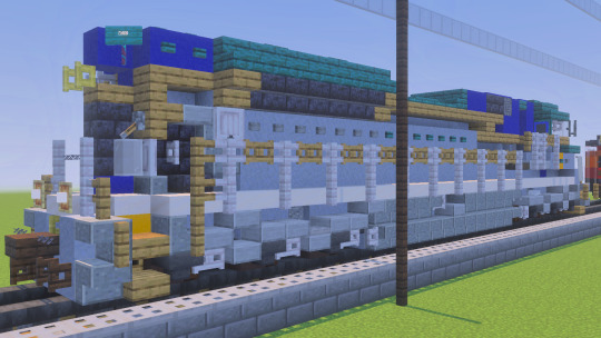
I bet some of you should've expected me to build Norfolk Southern's Delaware & Hudson heritage unit. And on top of that, this is my first time using Vibrant Visuals for anything Minecraft related.
Credits to CraftyFoxe for the SD70ACe design
#Minecraft#Minecraft Build#Minecraft Build Showcase#NS#Norfolk Southern#Norfolk Southern Railway#D&H#Delaware & Hudson#Delaware & Hudson Railway#NS 1080#Norfolk Southern 1080#Heritage Unit#NS Heritage Unit#EMD#SD70ACe#EMD SD70ACe#Diesel Locomotive#Trains
27 notes
·
View notes
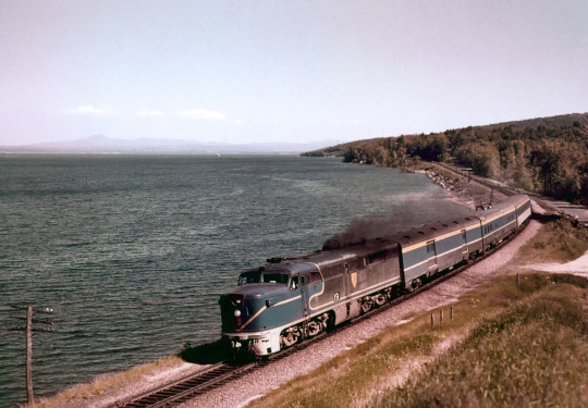
Text

MNCR 5043, Katonah, NY, 1983
Metro-North's early days were not easy, A southbound Harlem Line train approaches Katonah the morning after a blizzard dumped more than two feet on the area on February 13, 1983. A former New Haven FL9 leads a set of coaches originally rebuilt for Delaware & Hudson/Amtrak Adirondack service.
Art Deeks photo
#commuter train#mncr#metro north commuter railroad#mta#metropolitan transportation authority#d&h#delaware & hudson#1983#new york city#trains#passenger train#history#katonah#new york
34 notes
·
View notes
Text
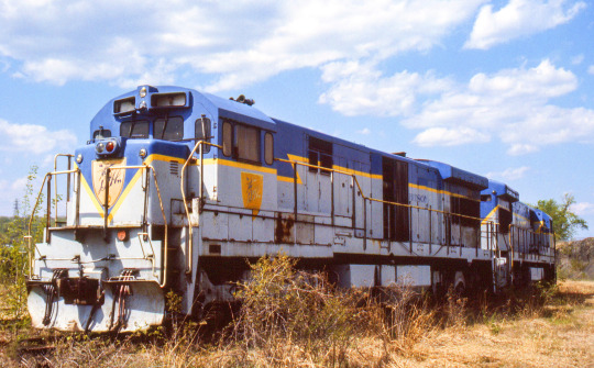
DH 49
A bit of a sad sight, U33Cs 757 and 754 wasting away out behind the main shop building at Colonie in May of 1987.
55 notes
·
View notes
Text
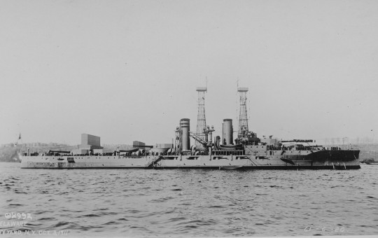
USS Delaware (BB-28) during the Fleet Review on the Hudson River, New York.
Photographed on October 3, 1911.
NARA: 55167376
#USS Delaware (BB-28)#USS Delaware#Delaware Class#Battleship#Dreadnought#October#1911#Hudson River#warship#ship#boat#fleet review#review#naval review#East coast#new york city#New York#united states navy#us navy#navy#usn#u.s. navy#my post
12 notes
·
View notes
Text
youtube
Proper British Bikes at Bikes and Breakfast... ...and Proper British behavior at Van Sant Historic Airfield
It was all unofficial of course, but a plethora of British iron some how (cheeky!) made its way to Bikes & Breakfast in Palisades, New York this past Sunday. After that I rode my imitation Brit bike (Kawasaki W800 Cafe) to the Van Sant Historic Airfield in Erwinna, Pennsylvania. Still on a high from seeing British front drum brakes I channeled the naughty Benny Hill -- and got away with it without being given what for.
Music: God Save the King performed by the Royal Philharmonic Orchestra, Hilary Davan Wetton, conductor, and Mr. Airplane Man by Howlin' Wolf (yes, I combined them indeed)
#Bikes & breakfast#british motorcycles#triumph motorcycles#bsa motorcycles#Kawasaki w800 cafe#Van Sant historic airfield#biplanes#covered bridges#turbosteve#saddle bums#Hudson valley motorcycle touring#Delaware valley motorcycle touring#Vincent motorcycles#benny hill#Youtube
3 notes
·
View notes
Text
New York City Declares Drought Warning Amid Water Crisis
New York City Elevated to Drought Warning On Monday, Mayor Eric Adams announced a significant escalation in New York City’s water management strategy by elevating the existing drought watch to a drought warning. This warning represents the final step before the city may declare a drought emergency, which would trigger mandatory water conservation measures. This drought warning not only affects…
#climate crisis#Delaware Aqueduct#drought emergency#drought warning#Governor Kathy Hochul#Hudson Valley#Mayor Eric Adams#New York City#rainfall#reservoirs#water conservation#water supply
0 notes
Text
Take a Walk 09/22/24 - Albany, NY Special Edition
Just a note to the 3 day-one fans/followers of my take a walk commentary series, I have a few posts to catch up on that are dated and slated to be put together as soon as I find the time. But I just wanted to get this special edition out as soon as I could because its fresh and I have the motivation to and this one is short. (And because this is my blog, and I make the rules, and were doing this one first!!)
While I was visiting my friends in Albany, a place I called home for a number of years, I had some time to kill so my old friend and I decided to take a long walk and shoot some photos. :)

First off we have the Hinckel Brewery building originally built as just the right-most building in 1855, with additions made in subsequent years as the business began to grow to be one of the biggest beer distributors in the Northeast even rivaling Anheuser-Busch and Samuel Adams during the early 1900's.
The original architect is unknown, but to the best of my understanding many of the building's interiors as well as the surrounding building complex have been modernized and incorporated into the @HudsonPark apartment scheme. I wasn't able to find a lot of info on the apartments that exist therein within the apartment complex, and they don't exactly have rave reviews on sites like google and apartments.com.
When we walked into the small inner concrete courtyard underneath the old docking bay in the office building, the vibe was very vacant aside from being locked and then this strange noise I caught of one of the seemingly-annoyed tenants who wasn't happy we were all up in their business. (either that or it was a ghost, give the sound a listen in the last 5 seconds of this video and let me know lol).
-
Then we walked past some of my favorites, that I neglected to get pictures of -_- bc I didn't think I would be making this post, BUT that I'll def be able to get pictures of from my archives/google. I'll throw together a short run through of those real quick and then get to the main event.
-


The Van Ostrande-Radliff House at 48 Hudson Ave, a must see (even if you cant see much) in Albany. This is the oldest standing building in the city, originally built in 1728. Preservation efforts are ongoing to restore it to its former charm, but it remains covered for the time being so as to not fall into further disrepair. I recommend checking out the sick pictures that Historic Albany Foundation has on their website of the current interior.
-


Down the street is the SUNY Headquarters Building, an old railroad building that served the state capitol under the Delaware & Hudson Railroad Co. Architect Marcus T. Reynolds designed this one, it was originally built as six separate buildings from 1915 on and connected to form one continuous structure, this imposingly beautiful Flemish Gothic building is one of my personal favorites in downtown Albany.
-

Turning around we see this beautifully ornate neo-classical building at the corner of State St. & Broadway. Originally built as the Albany Trust Company building in 1902, also by architect Marcus T. Reynolds! This building has such a striking facade and the renaissance revival dome is truly an architectural masterpiece (if not bordering on a little gaudy). I was so lucky to find out they had just given it a fresh spruced up paint job when I walked by it! Today it operates as the SUNY Research Foundation building.
-


Then juuuust up the street 2 buildings away is BY FAR my favorite little guy in the city (I would treat her so right, please god give me a chance).
This is 63 State St. Being built originally by one of my favorite architects, Russell Sturgis in 1876 for the Mechanics & Farmers Bank. For such a small sliver of a property footprint this building just does so much right with its balance of form and ornament. The turret on the corner is stunningly delicate, as well as the bright red brick to complement the light sandy stone. Not to mention that beautifully ornate third floor circle window. This building changed hands a couple times throughout the centuries but retains the old vault door in the basement as well as the brass fixtures and marble floorings inside that give it quite the stately presence upon entering.
-

How could I not include the most imposingly large, ornate, stately, balanced (every other adjective I've ever used on this blog...) building in Albany, the state capitol building!? Main architect: Henry Hobson Richardson, along with Leopold Eidlitz, Thomas Fuller, and Isaac G. Perry. Finished in 1899 after 32 years!
I'm going to keep this very brief because we only stopped here briefly on our walk and this building deserves it's own deep dive post at some point anyway. Plus it isn't even the aforementioned "Main Event" of our walk. But the detail in the scrolling on the columns here is absolutely insane. My friend and I were discussing it's architectural style/influences and we weren't completely convinced it falls into any one, Italianate/Neoclassical/Victorian/Georgian/Flemish/Gothic/Spanish influences... the confluence of styles in this design is absolutely masterful. As well as whether one would consider the columns corinthian or not, maybe composite? But just take a look at these bad boys, I would sit and take a full semester's course just on the symbolism sprinkled in and throughout this structure.

The scrolling is unique on EVERY column and sprinkled with tons of historical imagery and symbolism but they all have the same visual weight and if you weren't paying attention you'd never notice.
-


If you think nothing could compete with the capital building's insanely intricate detail look across the street for it's closest competitor, The State Education Department building and Chancellor Hall at 89 Washington Ave. I think I remember thinking for a long time this was my favorite Albany building for years before discovering the charming old gothic bank building on lower State St.
Spanning a whole city block (a long one) is this building's imposing Greek-revival corinthian colonnade with 36 massive columns along it! Another scale-defying building joining the capitol building at you-have-to-see-it-in-person scale, the columns on this bad boy are comparable to the width of a redwood tree (see the picture of my legs as I lay down between them to get shots of the ceiling).
Originally Built in 1911 by architect Henry Hornbostel, this building has retained it's integrity and intention by functioning as the base of operations for the NY state education system since its completion. Its structure and facade, including the intricate brass lighting fixtures and the beautiful tiling along its exterior, has been kept in immaculate condition and is incredible to look at in person. This is another architectural feat with such minute detailing that I could sit there with an expert for probably weeks just in awe of it's symbols and attention to detail. I sat there for about 20 minutes when we visited it just looking at it and taking its beauty in. This is the type of building that just transports you somewhere else when you really take it in, it could've easily been cherry picked from the acropolis and plopped in upstate New York and you wouldn't question it thats how beautifully true to form it feels in person.
I didn't know I would be making this post in the moment while taking the walk so I don't have a dishonorable mention, but if you've ever been to Albany, NY you know there are far too many of those to ever pick from so I'm going to give myself a pass this time.
#albany ny#architect#architecture#cast iron#greek revival#romanesque#column#italianate#mansard roof#art#Hinckel Brewery#@hudsonpark#Marcus T. Reynolds#Henry Hornbostel#russell sturgis#Van Ostrande-Radliff#Van ostrande-radliff house#Jared Holt#Historic Albany Foundation#SUNY Headquarters#SUNY#NYS Education Department#neoclassical#Albany Trust Company#Mechanics & Farmers Bank#D&H#Delaware & Hudson#Delaware & Hudson Railroad Co.#Flemish Gothic#Gothic
1 note
·
View note
Text
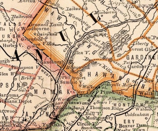
American Auto Trail-Delaware & Hudson Canal (Kerhonkson to Cuddebackville NY)
American Auto Trail-Delaware & Hudson Canal (Kerhonkson to Cuddebackville NY) https://youtu.be/rjWLWJQ9ZkU This American auto trail explores the path of the Delaware & Hudson Canal in southeastern New York State.
View On WordPress
#4K#american history#Auto trail#canal#delaware#driving video#Ellenville#Hudson#new york#Ontario#railway#road travel#slow travel#Wurtsboro
0 notes
Text
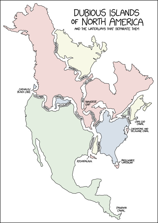
Running for office in Minnesota on the single-issue platform 'dig a permanent channel through the Traverse Gap because it will make this map more satisfying.'
Dubious Islands [Explained]
Transcript Under the Cut
[Title:] Dubious Islands of North America [Subtitle:] And the waterways that separate them
[A map of mainland North America, down to the Panama isthmus. It is internally separated by various waterways, given labels or otherwise.]
[Separating land approximating Nunavut (with some Northern Territories) from neighbouring Canada:] Mackenzie Athabasca Churchill
[Comprising the much of the remainder of Canada, much of the northern United States (including Alaska), additionally separated by:] Columbia Snake Madison Missouri Chicago
[Unlabelled, some of the Great Lakes and the channel past Quebec] [An incursive gap near the central point, from the north:] Nelson Red [An internal label, with arrow:] Traverse Gap [An incursive gap near the central point, from the south:] Mississippi [A separate fragment of land south of the Madison, in the western half of the land-mass, bordered to its south by:] Yellowstone [A small fragment off the southen part of the western edge, an arrow and a label:] Chehalis/Black Lake
[Nova Scotia, New Brunswick and parts of the adjacent US, disconnected by:] Champlain Hudson [Label with an arrow on the east coast:] Cape Cod Canal
[A small triangle of territory, further isolated by:] Erie
[Most of the Eastern Seaboard of the US, additionally divided off by:] Tombigbee
[Fragment of land shorn from the northern part of the eastern edge, label with arrow:] Chesapeake and Delaware Canal [Fragment of land shorn from the tip of Florida, label with arrow:] Okeechobee Waterway
[Strip of land west of the Tombigbee, bounded also to its west by:] Mississippi [Fragment of land immediately to its south, with a nearby label and arrow:] Atchafalaya
[The remainder of the continent; comprising much of the US, all of Mexico and various central American territories, with a final tip of the eastwards-bending isthmus:] Panama Canal
558 notes
·
View notes
Note
Tbh I was always under the impression Metropolis is NYC and Gotham is Boston. Like iirc Arkham is based on an asylum that was in Danvers MA? The east coast city rivalry vibes feel pretty identical to me. Gotham's organized crime has big whitey bulger energy to me idk.
Gotham has always been adjacent to NYC.
Before DC decided NYC was a real place in their universe, Gotham and Metropolis were considered to be the light and dark side of the same Bay Area, taking up residence where NYC would be. Afterwards, Gotham has always been placed squarely across the Hudson River from NYC in North NJ. Until they couldn’t decide where Metropolis is.
Metropolis is a child of divorce.
The first time DC claimed it was in Delaware was the 70’s. (I don’t know why. They just did.) I think DC realized that making NYC a part of the universe meant they couldn’t make Gotham and Metropolis twin cities anymore so now, whenever they want to bring that dynamic back, they either ignore NYC altogether or move Gotham to the Delaware Bay and claim Metropolis is in Delaware.
But ever since Metropolis was a city, it’s been in NY. It’s been in NY since the 30’s. Usually, it’s placed somewhere above Manhattan, particularly near Westchester or just outside of the NY Metropolitan Area. So in my head, it’s about an hour above NYC but still west of Connecticut.
I like the concept of them being twin cities, but they have such different vibes that I can’t imagine them being right beside one another, and I think a lot of comic writers know that too. So I always place Metropolis in NY. Maybe it’s further upstate like DC sometimes claims, but Gotham and Metropolis are always within three hours of each other without fail.
But yeah, the more you know :) toodles
#I totally see the Boston thing tho#kind of like how some people think Metropolis is Chicago#DC why do you make everything so hard#pick one#and put Metropolis in NY#Gotham#metropolis#batman#superman#dc universe#dc#Gotham city#Bruce Wayne#clark kent
189 notes
·
View notes
Text
Campottonì and Gorram
some notes on a pair of cities in New Provence, situated across a bay from each other.
Campottonì (Doccian /kãˌpɔ.tuˈni/; Merch /kɐmˈpɔ.tʊ.ni/) is a coastal city on the southern bank of the Guittoc [Delaware] river, in the Nappejoquin [1] region of New Provence. Founded in the late seventeenth century as a Provincial staddomain, it was intended to be a major trading port and to control the flow of goods along the Guittoc.
The second half of the placename reflects the Nappe term [Unami] utaney "city"; the first half is of obscure origin (clearly adapted to Doccian camp "field") but may be related to Nappe necama "first". In this case the toponym likely means "mother-city, home city"; compare the similar formation of μητρόπολῐς "metropolis" in Ancient Greek.
The settlement languished through the eighteenth century due to unfavourable, marshy terrain and the better harbours across the river and further inland. Fortunes changed in the nineteenth with an influx of funds: a major shipping canal across the peninsula (connecting the Guittoc to the wealthy Esquanna [Susquehanna] river system) was dug, and the marshlands surrounding Campottonì were drastically canalised and drained. Further widening of the canal took place into the twentieth century.
Briefly known as the "Venice of Mendeva [North America]", Campottonì gained a fashionable reputation during the Good Game Period [late 19C] and by the modern day had risen to become a cultural and economic powerhouse.
-
Gorram (Doccian /guˈram/; Merch /ˈgɔ.ɾəm/) is a coastal city on the northern bank of the Guittoc river, in the Nappejoquin region of New Provence. It had extremely humble beginnings as a single Provincial farmhouse or possibly a collection of pastures.
There are Provincial dialect terms gorra "goat" and gorram "herd of goats" cognate with cavra and cavram in standard Doccian—the suffix -am forming collective nouns descends from -(ā)men in Latin—and this is generally agreed to be the origin of the placename; compare the similar formation of Gotham (Merch /ˈgɔ.təm/), a village in Markland.
For a time in the eighteenth and nineteenth centuries, Gorram became by far the most important city on the river, having a better natural harbour. It also participated in the convoy [train, rail] craze of the mid-nineteenth century, being the terminus of an arterial line to the northeast.
Even into the twentieth century Gorram was a major hub of industry on a par with Campottonì. However, by the modern day a lack of infrastructural investment in its own drained land and an inability to deindustrialise gracefully had led the city to become much poorer than its counterpart across the bay.
===
[1] approximately the watersheds of the Delaware and the lower Hudson.
8 notes
·
View notes
Video

flickr
Midwest Monday por Brian D Plant Por Flickr: The much-anticipated Delaware & Hudson heritage unit debuted this Spring and is seen at South Bend, Indiana under heavy mid-day sun conditions on its second revenue run in the lead. Believing the unit to be a possible candidate to lead a Sunday morning 310 east of Elkhart, I headed out in the wee hours to position myself for a potential chase. Unbeknownst to me, the locomotive had gone from Elkhart to Blue Island overnight with train 35J. So when I was crossing the NY/PA border, I started receiving messages that it was going to be on the following day’s 34J, but then it was reported at Dolton, Illinois heading back east to Elkhart already. At this point, I thought I was out of luck for the D&H and would focus on trying to get some Wheeling action. But that ended up not happening and I then found myself hustling west trying to make a Hail Mary pass in the city that is home to the Notre Dame Fighting Irish football team. I was joined by TheBigKV for the 34J at CP 435, while it wasn’t ideal lighting conditions, and the horn sounds like crap, I was in amazement at the sight of a real third generation diesel locomotive in D&H lightning stripe paint. My father and his two brothers helped me become a huge D&H fan from a young age, through their old slides and seeing what was left of the D&H. I was there through the depressing Guilford strike years, the uncertainty, but bright hope of Susquehanna operator era, to the brief return of the Lightning Stripes from M-K Mountaintop, and the deep investment into the physical plant from CP RAIL. The D&H has survived lean times and while it’s not what it once was, it still remains a vital link as “the Bridge Line to Canada and New England”
5 notes
·
View notes
Text

First car is former D&H diner. Chappaqua, NY April 27, 1982
#commuter train#cr#conrail#mta#metropolitan transportation authority#pc#penn central#nynh&h#new haven railroad#d&h#delaware & hudson#1982#new york city#trains#passenger train#history#chappaqua#new york#dining car#diner
14 notes
·
View notes
Video
Fresh Lightning Stripes by Erie Limited Via Flickr: Somewhat fresh from rebuilding at M-K in Mountaintop, PA, D&H 7401 poses for a portrait at Kenwood Yard in Albany. 7401 was outshopped about a month prior to this photo. In that time it acquired a bit of grime on the long hood. The following year it would be sold to CSX where it still operates today as CSXT 4309.
DH 7401 GP39-2 (ex-RDG 3401) July 17, 1990
30 notes
·
View notes
Text
What-If: American Railroads — Maps
I deeply apologize for not coming back to this alternate railroad history topic in over a year, I’ve had a lot of other things to do and i merely scratched the surface of this railroad history topic. and therefore, I’ve thought long and hard about this whole thing.
Aside from that apology, i thought to myself since I have Procreate, why not make maps of the 20 American railroads in my alternate history about said American railroads? And that’s what I did. Each map below shows the 20 railroads after they absorbed the smaller railroads as well as some of them expanding their networks in the 1980s wherever possible.

New York Central — this map shows the New York Central after the road to the future absorbed Boston & Maine, New Haven , Delaware & Hudson, Rutland Railroad, Bangor & Aroostook, Central Vermont And Maine Central railroads.
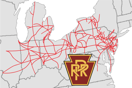
2. Pennsylvania Railroad — This map shows the size of the Pennsylvania Railroad after it absorbed Lehigh New England, Reading Lines/Railroad, Richmond, Fredericksburg and Potomac, Lehigh Valley, Lehigh and Hudson River, Central Railroad of New Jersey, Grand Trunk Western and Pennsylvania-Reading Seashore Lines railroads.

3. Chesapeake & Ohio — This map shows the Chesapeake & Ohio after it acquired the Erie Railroad, Lackawanna Railroad and New York, Ontario & Western Railway, plus the northern section of the Louisville & Nashville Railroad throughout the 50s and 60s, as well as expanding its network in the 80s.
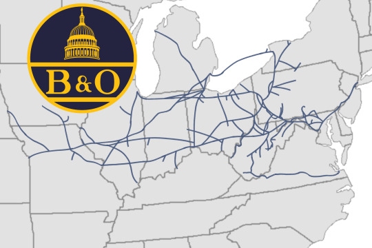
4. Baltimore & Ohio — This map shows how big the Baltimore & Ohio got after America’s first railroad absorbed Pittsburgh and Lake Erie, Western Maryland, Wabash, Ann Arbor, Virginian railroads.
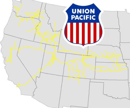
5. Union Pacific — Here, this is how big Union Pacific got after absorbing the Western Pacific and Rio Grande railroads, as well as adding more mainlines in the eighties.
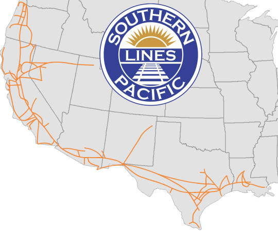
6. Southern Pacific — This map shows the Southern Pacific after adding more mainlines to its network in the eighties.
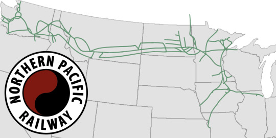
7. Northern Pacific — For this map, it shows how big the Northern Pacific Railway got after absorbing the Chicago Great Western and Duluth, Missabe and Iron Range railroads, as well as adding more mainlines to its network in the eighties.

8. Milwaukee Road — This map shows how big the Milwaukee Road got after the “Route of the Hiawatha” expanded its network by widening its existing mainlines and adding more mainlines (wherever possible) and expanding to northeastern Minnesota throughout the eighties.

9. Burlington Route — This map shows the Burlington Route after it absorbed the Kansas City Southern in the early 1960s and later expanded its network in the eighties.
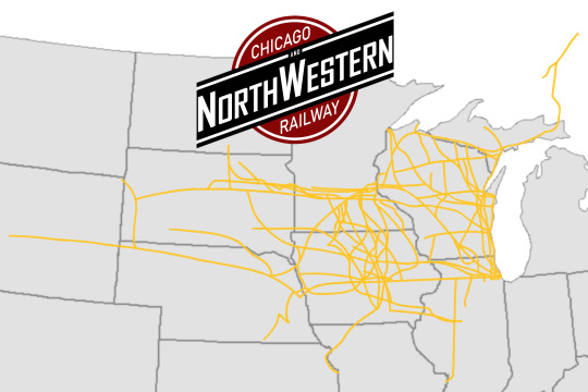
10. Chicago & NorthWestern — This map shows the size of Union Pacific’s ancient partner; the Chicago & NorthWestern, after it absorbed the Wisconsin Central and the Minneapolis and St. Louis railroads in the 60s plus expanding its network in the 80s.
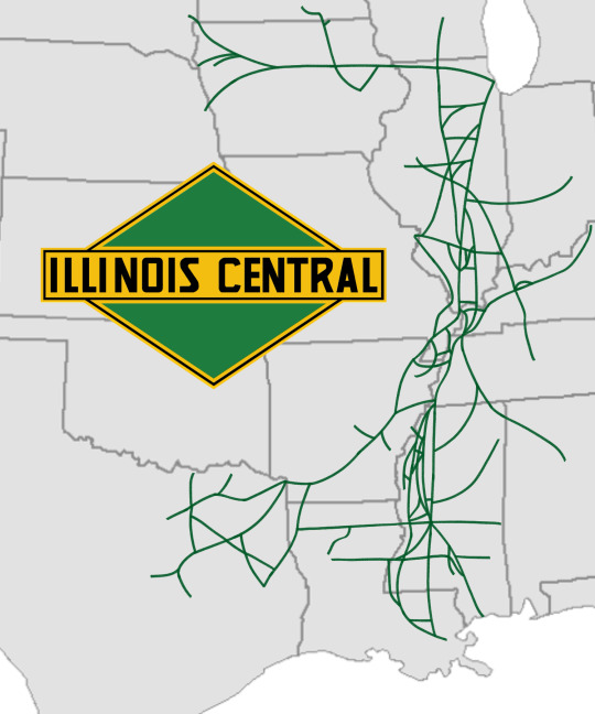
11. Illinois Central — This network map shows how big the Illinois Central got after acquiring the Cotton Bell Route in the 60s plus expanding its network in the 80s.
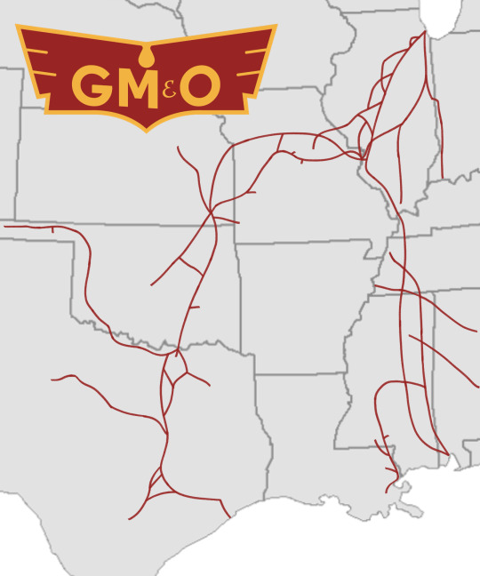
12. Gulf Mobile & Ohio — This map shows the size of the arch rival of the Illinois Central; the Gulf Mobile & Ohio, after it acquired the Chicago & Eastern Illinois and Missorui-Kansas-Texas railroads
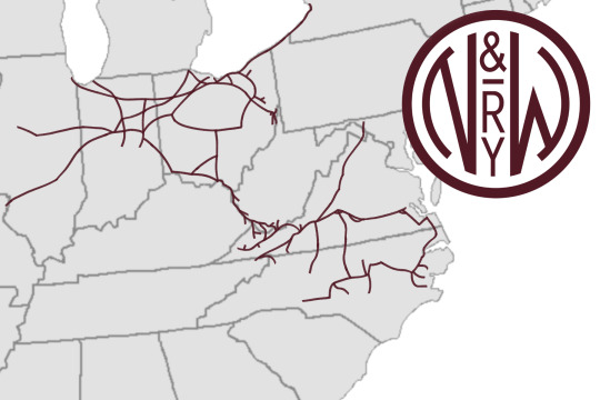
13. Norfolk & Western — Here, the map of the Norfolk & Western shows how big the N&W got after absorbing Nickel Plate Road and the (original) Norfolk Southern in throughout the 50s and 60s.
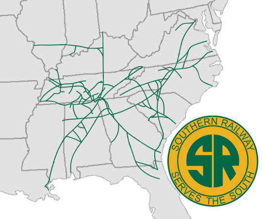
14. Southern Railway — This map of the Southern Railway shows how big the Southern got after absorbing Nashville, Chattanooga & St. Louis railroad and the central section of the Louisville & Nashville railroad in the 50s and 60s, as well as expanding its network in the 80s.

15. Seaboard Air Line — here, the Seaboard Air Line is shown how big it got after acquiring the Central of Georgia and West Point Route railroads plus the southern section of the Louisville & Nashville Railroad.
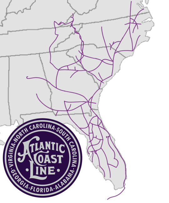
16. Atlantic Coast Line — This map shows how big Atlantic Coast Line after it absorbed Clinchfield Railroad, Oneida and Western and Florida East Coast railroads throughout the late 50s to late 60s.
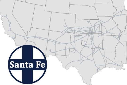
17. Santa Fe — This map shows the Santa Fe Railway after it absorbed half of the Frisco railroad in the early sixties and later expanded its network in the eighties.
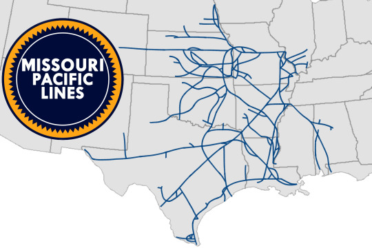
18. Missouri Pacific — This map shows the size of the Missouri Pacific after it absorbed the other half of the Frisco railroad and the Texas & Pacific Railroad in the early to late sixties.
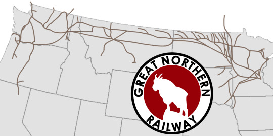
19. Great Northern — This map shows the size that Great northern Railway underwent after absorbing the Spokane Portland and Seattle Railway and adding more mainlines.
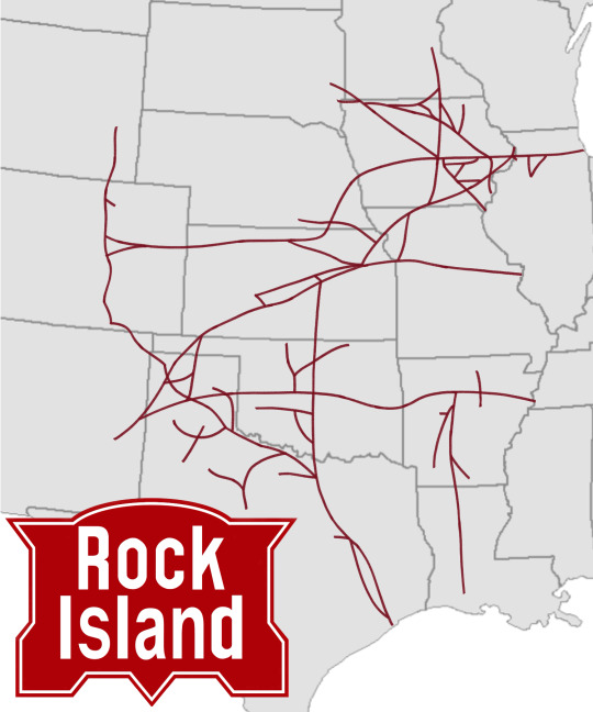
20. Rock Island — This map right here shows how big the Chicago Rock island and Pacific Railroad, or the Rock Island Railroad for short, has gotten after absorbing the Colorado and Southern Railroad and adding more mainlines and connecting to other mainlines order Rock Island ownership.
And with that, these maps show how big the railroads above have gotten. And since I’ve just returned to this topic, I’ll dig deeper into my thoughts and ideas about how things would go in this alternate timeline, which includes more posts talking about the history and posts talking about the locomotives and liveries on said locomotives, so stay tuned for all that.
#history#alternate history#alternate universe#railroad map#alternate timeline#new york central#pennsylvania railroad#chesapeake & ohio#baltimore & ohio#union pacific#southern pacific#northern pacific#milwaukee road#burlington route#chicago & north western#illinois central#gulf mobile & ohio#norfolk and western#southern railway#seaboard air line#atlantic coast line#santa fe railroad#missouri pacific#great northern#rock island#map#maps
8 notes
·
View notes