#Geospatial Imagery Analytics Market 2017
Explore tagged Tumblr posts
Visit Tumblr Blog
Explore Tumblr blogs with no restrictions, modern design and the best experience.
Last Seen Tumblr Blogs


Fun Fact
25% of US internet users with an annual income of $80-100K use Tumblr.
Text
Synthetic aperture radar finally shedding its mystique
https://sciencespies.com/space/synthetic-aperture-radar-finally-shedding-its-mystique/
Synthetic aperture radar finally shedding its mystique
When Capella Space’s first operational synthetic aperture radar satellite launched from New Zealand last month on a Rocket Lab Electron, a team of agriculture specialists at The Climate Corporation watched with excitement.
“We were really happy,” said Steven Ward, the director of geospatial sciences at The Climate Corporation, a San Francisco-based subsidiary of life sciences and pharmaceutical giant Bayer that leverages satellite imagery to help farmers boost crop yields and insure against weather-driven losses. “We actually had a Slack channel where we were celebrating that launch.”
The Climate Corporation processed 600 million satellite images in 2019, most of it optical, Ward said. The company hasn’t integrated synthetic aperture radar, or SAR, imagery into its Climate FieldView product line yet, but is studying how radar, which can peer through clouds, could fill gaps left by optical satellites over notoriously cloudy regions like Brazil, Indonesia and the Niger delta, he said.
“We’re getting bits and pieces of the story of the field,” Ward said. “What adding SAR data into the mix does is it fills in the gaps. We’re missing chapters, and it’s filling in those chapters.”
The Climate Corporation integrates satellite imagery with other data sources, streaming mapped progress directly to computer-equipped farming machinery. Farmers are able to see and analyze the progress of planting, crop protection, and harvesting in real time using satellite imagery. Credit: The Climate Corporation
SAR satellites can gather data day and night, and through all weather conditions, but the resultant imagery is typically more expensive, less available, and more difficult to use than optical imagery.
Technological advances, as much on the ground as in space, are breaking down those barriers, positioning SAR for much more widespread adoption, according to experts.
“For the first time in history, the ground segment is ready, the cloud computing is ready, and the SAR satellite systems are ready,” said Alexis Conte, a Euroconsult analyst specialized in the geospatial sector. “It is promising.”
Before joining Euroconsult in 2017, Conte worked for France’s agriculture ministry where it proved challenging to get SAR imagery quickly because cloud computing was still nascent, he said. Now, SAR customers can easily use cloud platforms like Amazon Web Services, Conte said, or access imagery through web portals from SAR providers Maxar Technologies and Airbus Defence and Space that include analytical tools to process SAR data.
A wave of startups including Capella Space, Iceye, iQPS Inc., PredaSAR, Umbra Labs and Synspective have launched or are preparing to launch SAR smallsats that promise faster revisit times and lower costs, he said.
“They are going to drive the market,” Conte said of the several smallsat SAR constellations in the offing. “They are lowering the price because the [capital expenditure for] each satellite is very low.”
SAR DEMAND ON THE INCREASE
So many new constellations are in development that the U.S. National Geospatial Intelligence Agency conducted a study this year to better understand the state of commercial SAR, said Jared Newton, the special projects officer for NGA’s source commercial and business operations group.
“The U.S. commercial market has really sprung up hot and heavy in the last couple of years, so we had to go back and re-look at opportunities that we think we could apply SAR commercial capabilities,” he said.
That internal study concluded that commercial SAR can help meet U.S. geospatial intelligence needs, Newton said.
“We definitely see expanded opportunities for private sector SAR, particularly RADAR LOVE as that demand for unclassified and sharable geoint has increased,” he said.
NGA will use those findings to inform requirements for the National Reconnaissance Office, the U.S. spy satellite agency responsible for acquiring imagery needed for military and intelligence operations.
The European Union’s maritime safety agency, EMSA, also sees an increasing need for SAR data, particularly for its Copernicus Maritime Surveillance program, which provides Earth-observation products to member governments for law enforcement, fishery management, pollution monitoring, and other applications. The European Union’s 27 member states plus Iceland, Liechtenstein, Norway, and Switzerland are entitled to use the agency’s SAR-derived products, EMSA said in a written response to questions from SpaceNews.
“The demand for [SAR] services has been increasing as users acknowledge the added value of this tool for maritime surveillance when offered in near real time,” EMSA said.
EMSA’s Copernicus Maritime Surveillance program is driving much of that growth, EMSA said, by buying Radarsat-2 data through MDA and TerraSAR-X data through Airbus. EMSA also relies on free SAR data from Europe’s Sentinel-1 satellite to detect oil spills under a separate program called CleanSeaNet.
“The objective of EMSA is to maintain access to as many missions as possible and a portfolio of providers as large as possible to be able to address all requests at any time,” the agency said.
THE NORMALIZATION OF SAR
While defense and intelligence agencies remain the largest consumers of SAR imagery, commercial applications are the fastest growing segment of the market, Conte said. Customers in agriculture, energy, finance, infrastructure and other sectors are all adopting SAR, which they often use in ways that are complementary to optical imagery, he said.
Geospatial data customers accustomed to optical imagery often view SAR as an add-on, not a substitute, for other information sources. The Climate Corporation hopes to add SAR to infotech products that already incorporate data from weather instruments, farm machinery and optical satellites to provide an even fuller understanding of crop health, Ward said. No single source of data provides the whole picture, he said.
Ursa Space Systems, a geospatial analytics company that specializes in SAR, has blended SAR images with optical photos from BlackSky’s nascent satellite fleet and ship-tracking data from Spire’s sizable cubesat constellation to provide more comprehensive maritime products, Ursa CEO Adam Maher said.
Combining SAR with other data helps Ursa sell imagery products to customers in a wide variety of industries, many of which weren’t familiar with SAR until recently, he said.
“In oil and gas, our customers were very used to optical, but now having SAR has become a selling point,” said Maher.
SAR satellite operators face the two-pronged challenge of making potential customers aware of their imagery, and making their imagery readily usable for those customers.
SAR is not as big a business as optical imagery, but it is projected to grow steadily in the years ahead. Credit: Euroconsult
Ursa is one of the “larger consumers” of SAR data, Maher said, relying on e-Geos, SI Imaging Services, Iceye and others for imagery that it feeds into analytics dashboards for provide rapid change detection alerts.
Maher said demand for SAR is coming from virtually every industry. “Being able to understand what’s going on in parts of the world that are not easily accessible to optical satellites is really important,” he said.
Putting SAR imagery to work does come with challenges, Maher added. Details that are obvious in optical images are easy to miss in SAR images without special training or software designed to interpret the data, he said.
To the untrained eye, a SAR image looks like a “bunch of black and white speckled dots,” Maher said. Ursa focuses heavily on training computer algorithms to detect objects of interest from those images, he said.
Even geospatial specialists at The Climate Corporation had a tough time interpreting radar imagery they were working with as part of the company’s recent SAR suitability study, Ward said.
“The data is big and unwieldy, and it doesn’t come cleanly packaged. Even some of my most well versed and best remote sensing scientists didn’t have a lot of experience working with radar data,” he said. “There was a learning curve there because so many institutions focused on teaching purely optical imaging, but we’re seeing a bit of a shift there.”
When it comes to understanding SAR, Euroconsult’s Conte said the onus should lay more heavily on SAR providers to deliver data products their customers understand.
“The operator will have to be educated about end-user expectations and first get a good knowledge about their world in order to deliver the appropriate services,” he said.
Getting familiar with new customers and their markets will help the satellite industry communicate about SAR to an even larger audience, Ursa’s Maher said.
“It’s really important to make sure when we’re educating other folks that we’re educating them in the languages and industry knowledge that they know,” he said.
This article originally appeared in the Sept. 14, 2020 issue of SpaceNews magazine.
#Space
1 note
·
View note
Link
The global geospatial imagery analytics market accounted for USD 3.02 million in 2016 growing at a CAGR of 32.3% during the forecast period of 2017 to 2024.
http://databridgemarketresearch.com/reports/global-geospatial-imagery-analytics-market/
#Global Geospatial Imagery Analytics Market#Geospatial Imagery Analytics Market#Geospatial Imagery Analytics Market 2017#Geospatial Imagery Analytics Market Size#Geospatial Imagery Analytics Market Share#Geospatial Imagery Analytics Market Trends#Geospatial Imagery Analytics Market Growth#Geospatial Imagery Analytics Market Overview
0 notes
Text
0 notes
Text
Geospatial Imagery Analytics Market Share, Demand and Current Trends Analysis Till 2027
The geospatial imagery analytics market, in terms of value, is estimated USD 3.75 Billion in 2017 and is expected to grow rapidly during the forecasted period at a good CAGR.
The global geospatial imagery analytics market is segmented by analytics into image analytics and video analytics; by technology into global positioning systems (GPS), geographical information systems (GIS), remote sensing, unmanned aerial vehicles (UAVS) and others (helicopters, balloons, and airships); by vertical into defense & security, insurance, agriculture, healthcare & life sciences and others; by application into surveillance & monitoring, construction & development, energy & resource management, geospatial, conservation & research, disaster management, exhibition & live entertainment and others.
Geospatial imagery analytics is a wide range solution system which provides both image and video data of the earth. Geospatial imagery analytics support to integrate, operate, gather, examine and display geospatial data which is collected through GPS, satellite imagery, mapping and many other sources. The geospatial imagery analytics market, in terms of value, is estimated USD 3.75 Billion in 2017 and is expected to grow rapidly during the forecasted period at a good CAGR.
In terms of regional platform, Europe holds the latest market share in geospatial imagery analytics market due the advance infrastructure for image collection and calibration which provides a promising environment for the adoption of geospatial imagery analytics technology.
Asia Pacific is expected to be the fastgrowing market for geospatial imagery analytics in terms of revenue due to growing urbanization, increasing adoption of geospatial technologies along with rising need for proficient space management and rising number of geospatial imagery analytics startups.
North America is expected to show to a rapid growth during the forecasted period. Hefty investments for the expansion of geospatial technologies and increase in the production of geospatial imagery analytics due to the demand for geospatial imagery analytics in varied range of verticals such as mining & manufacturing, environment monitoring, defense & security and utility & natural resources.
Download Sample of This Strategic Report @ https://www.researchnester.com/sample-request-733
Rising Penetration of Geographic Information System (GIS) Technology
It is expected that the global geospatial imagery analytics market is chiefly driven due to the increase in adoption of geospatial information system (GIS) technology. Rapid increase in the number of connected mobile devices led to rise in penetration of consumer navigation systems. GIS is widely used in disaster management and related applications such as climate change, flood management and carbon management. These factors are expected to drive the market growth of geospatial imagery analytics globally.
Through GIS technology users can analyze, integrate and detect patterns for large amounts of geospatial data sets. Numerous factors such as rise in geospatial information generated through smart phones, GPS devices and Google have resulted in the demand for GIS technology which further expected to increasethe demand for geospatial imagery analytics market globally.
Technological Advancements in Geospatial Imagery Analytics
Technological advancements are expected to drive the growth of the geospatial imagery analytics market globally. Generallywhen images are taken by several collection mediums they are manually processed which makes the process slow and complex. To overcome this problem, key market players are using artificial intelligence (AI), big data and deep learning technologies with geospatial imagery analytics technology.
These technologiesprovide a faster and more efficient analysis of data which are expected to drive the growth of geospatial imagery analytics market globally over the forecasted period.
Curious about this latest version of report? Obtain Report Details @ https://www.researchnester.com/reports/geospatial-imagery-analytics-market/733
Further, for the in-depth analysis, the report encompasses the industry growth drivers, restraints, supply and demand risk, market attractiveness, BPS analysis and Porter’s five force model. This report also provides the existing competitive scenario of some of the key players of the geospatial imagery analytics market which includes company profiling ofHexagon AB, Harris Corporation, Digital Globe, ESRI, Google, Trimble Navigation, Ltd., MDA Corporation, General Electric, Planet Labs, RMSI Private Limited, Satellite Imaging Corporation and WS Atkins Plc.
The profiling enfolds key information of the companies which encompasses business overview, products and services, key financials and recent news and developments. On the whole, the report depicts detailed overview of the global geospatial imagery analytics market that will help industry consultants, equipment manufacturers, existing players searching for expansion opportunities, new players searching possibilities and other stakeholders to align their market centric strategies according to the ongoing and expected trends in the future.
0 notes
Text
The Satellite Data Services Market for Government & Military Segment is Projected to Have Highest Market Share Based on End Use
Satellite data or satellite imagery is recognized as information about Earth and other planets in space, gathered by man-made satellites in their orbits. The most widespread usage for satellite data is Earth Observation (EO): satellites provide information about the surface and weather changes happening on Earth. This report is mainly focused on satellite data services for Earth. Satellite data having wealth of available authentic information about Earth's surface, weather, and other incidents are created via remote sensing technologies.
This research report categorizes the satellite data services market by vertical (Energy & Power, Engineering & Infrastructure, Defense & Security, Environmental, Agriculture, Maritime, Forestry, Transportation & Logistics, Insurance, Academic and Research, and Others )by end use (Government & Military, Commercial, Service Providers) by services (Image Data and Data Analytics), by Deployment (Public Cloud, Private Cloud, Hybrid Cloud) and by regions (North America, Europe, Asia Pacific, Latin America and Middle East &Africa).
The Satellite Data Services Market is segmented according to five key regions in this report, namely, North America, Europe, Asia Pacific, Middle East & Africa, and Latin Africa along with their key countries.
To know about the assumptions considered for the study download the pdf brochure
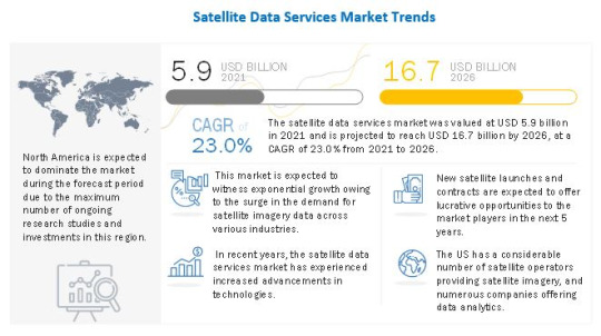
The satellite data services market is valued at USD 5.9 billion in 2021 and is projected to reach USD 16.7 billion by 2026, at a CAGR of 23.0% from 2021 to 2026. The US government invests in every part of the smallsat ecosystem and is likely to continue investing, both upstream and downstream, which would positively impact the satellite data services market. The more interesting development is the increasing investments in smallsats by other governments around the world.
Key Players
Some of the key players operating in the Satellite Data Services Market include Maxar Technologies (US), Planet Labs, Inc. (US), Satellite Imaging Corporation (US), ICEYE (Finland), Earth-i Ltd. (UK), and Airbus (Netherlands). These players cater to various verticals, including energy & power, agriculture, forestry, and defense & security, by providing high-resolution satellite imagery and image processing services for analysis.
MAXAR TECHNOLOGIES
Maxar Technologies (Maxar) was formed by the merger of Digital Globe and MDA Holdings Company on 5 October, 2017. The company had 4,400 employees in 2020 and is currently dual-listed on the Toronto Stock Exchange and New York Stock Exchange as MAXR. Maxar operates through two segments: Earth Intelligence and Space Infrastructure. The Space Infrastructure segment provides advanced surveillance and intelligence solutions, defense & maritime systems, radar geospatial imagery, space robotics, satellite antennas, and communication subsystems. The company has a presence in the US, Canada, Asia, Europe, South America, and Australia, among others.
L3HARRIS GEOSPATIAL
L3Harris Geospatial is an expert in providing scientifically proven geospatial solutions. The company offers industry solutions to the academic, defense & intelligence, federal & civil, maritime, utilities, transportation, and agriculture sectors. It uses software technologies, such as the Jagwire data management tool, MapMerger data conflation tool, and Geiger-mode LiDAR technology (which enables deep learning and uses artificial intelligence) to develop custom analytics and high-volume processing solutions.
Report Objectives
To define, describe, and forecast the satellite data services market based on vertical, end-use, service, deployment, and region.
To provide detailed information about the major factors (drivers, restraints, opportunities, and challenges) influencing the growth of the satellite data services market
To forecast the size of various segments of the satellite data services market based on 5 main regions—North America, Europe, Asia Pacific, Middle East & Africa, and South America—along with major countries in each of these regions
To analyze the micromarkets1 with respect to their individual growth trends, prospects, and contribution to the overall market
To identify industry trends, market trends, and technology trends prevailing in the market
To strategically profile the key players and comprehensively analyze their market position in terms of ranking and core competencies2
To benchmark market players using competitive leadership mapping, which analyzes players based on various parameters within broad business categories and strategies
To map the competitive intelligence based on company profiles, key strategies, and developments, such as agreements, contracts, partnerships, collaborations, and acquisitions.
About MarketsandMarkets™
MarketsandMarkets™ provides quantified B2B research on 30,000 high-growth niche opportunities/threats which will impact 70% to 80% of worldwide companies revenues. Currently servicing 7500 customers worldwide including 80% of global Fortune 1000 companies as clients. Almost 75,000 top officers across eight industries worldwide approach MarketsandMarkets™ for their pain points around revenue decisions.
#Satellite Data Services#Satellite Data Services Market#Satellite Data Services Industry#Satellite Data Services Market Size#Satellite Data Services Market Share#Satellite Data Services Market Trends#Satellite Data Services Market in United States#Satellite Data Services Market in Canada#Satellite Data Services Market in UK#Satellite Data Services Market in Japan#Satellite Data Services Market in Germany#Satellite Data Services Market in France#Satellite Data Services Market in South Korea#Satellite Data Services Market North America#Satellite Data Services Market South America#Satellite Data Services Market Europe#Satellite Data Services Market Asia Pacafic#Satellite Data Services Market Australia#Satellite Data Services Market ASEAN
0 notes
Text
Commercial Satellite Imaging Market Reporting Commercial Satellite Imaging Market Size, Share, Growth, Trends, Analysis, Regional Outlook and Forecast - 2027
Commercial Satellite Imaging Market by Application (Geospatial Data Acquisition & Mapping, Defense & Intelligence, Energy, Surveillance & Security, Disaster Management), End-User (Commercial, Defense), Type (Small, Middle, Large) - Forecast till 2027
Key Players:
DigitalGlobe (U.S.), Galileo Group (U.S.), SpaceKnow (U.S.), Airbus (France), Harris Corporation (U.S.), Planet Labs, Inc. (U.S.), Exelis Inc. (U.S.), Blacksky (U.S.), European Space Imaging (Germany), UrtheCast (Canada) and others are some of the prominent players profiled in MRFR Analysis and are at the forefront of competition in the global commercial satellite imaging market.
Commercial Satellite Imaging Market – Overview
The global commercial satellite imaging market is growing with the rapid pace. According to a recent study report published by the Market Research Future, The global market of commercial satellite imaging market will grow at a rapid pace over the forecast period. The market is forecasted to witness slow but steady growth by 2024, which will be a surplus growth at a moderate CAGR during the projected period (2018 -2024).
Commercial satellite imaging, well known as remote sensing, denotes the scanning of earth by satellite or high-flying aircraft to obtain geo-referenced information. The market for commercial satellite imaging is gaining attention with the growing requirement for disruptive satellite imagery data analytics by businesses throughout industries. It needs critical information and market understanding about various geospatial and environment conditions for efficient resource supervision.
Free Sample Report @ https://www.marketresearchfuture.com/sample_request/3249
Geospatial information acquisition & mapping has been the largest commercial satellite imaging market across the globe. In addition, commercial platform has been the major customer of commercial satellite imaging market. It include providers of map created services such as Apple Maps, and Google Maps.
The major trends witnessed in the global commercial satellite imaging market include hyper-spectral processing image for automatic target recognition. Most of the military applications are involve in identifying objects such as a movement of vehicle tracking with the help of hyper-spectral processing image. Moreover, the use of hyper-spectral picture sensors provide image data, encompassing both spatial and spectral information. In addition, it can be reduced to detect various activities as military activities. Moreover, development in high resolution satellite imagery for applications in data related sectors such as agriculture and natural resource managing, is also a factor considerably supporting to the growth of global commercial satellite imaging market.
Global commercial satellite imaging market is driven by factors such as technological development in satellite imaging in addition, application of satellite imagery in various sectors and growing demand of location-based services (LBS) sector. Satellite imaging is used in LBS for different applications, such as navigation, local search, consumer tracking, enterprise services, location-based business intelligence (BI), location-specific health information, etc.
The intensity of rivalry in the global commercial satellite imaging market is at lesser as compared to last couple of years. Majority of the vendors in the global commercial satellite imagery market are aggressively focusing on their business growth by implementing organic and inorganic growth strategies. Presently, the global market is heading towards merging by witnessing major partnership, and acquirements among major companies. For example, DigitalGlobe lately announced its partnership with Esri and Harris Corporation, the providers of advance geospatial information.
Industry/ Innovation/ Related News:
October 2017 – DigitalGlobe migrated its total 100-petabyte imagery library to Amazon Web Services (AWS). The acquisition is intended at building machine learning models that extract data from satellite imagery library, in demand to provide detailed business insights to their customers.
October 2017 – DigitalGlobe was acquired by Maxar Technologies. This acquisition is aimed at leveraging Maxar’s expanded revenue base, core businesses, and enlarge opportunities for the future growth.
Commercial Satellite Imaging Market – Segmentation
The global commercial satellite imaging market is segmented in to 4 key dynamics for the convenience of the report and enhanced understanding;
Segmentation by Application : Geospatial Data Acquisition & Mapping, Defence & Intelligence, Energy, Construction & Development, Surveillance & Security, Disaster Management and others.
Segmentation by End-Users : Commercial and Defence
Segmentation by Type : Small (Nano, Pico, Micro), Middle, and Large.
Segmentation by Regions : Comprises Geographical regions - North America, Europe, Asia-Pacific, Middle East & Africa and South America.
Access Report Details @ https://www.marketresearchfuture.com/reports/commercial-satellite-imaging-market-3249
0 notes
Text
Geospatial Imagery Analytics Market, Global Trends, Size, Opportunities, Sales Revenue, Emerging Technologies, Competitive Landscape, Key Vendors, Gross Margin by Forecast to 2027
The global geospatial imagery analytics market is expected to exhibit a strong 24.57% CAGR over the forecast period from 2018 to 2023, according to the latest research report from Market Research Future (MRFR). The global geospatial imagery analytics market was valued at USD 3.22 billion in 2017 and is expected to rise to a valuation of USD 11.16 billion by 2023, according to the report. The report presents a detailed analysis of the market’s major drivers and restraints, including an assessment of the impact of the COVID-19 pandemic on the market. The leading players operating in the global geospatial imagery analytics market are also profiled in detail in the report.
Top Impacting Factors
As per the study conducted over the global geospatial imagery analytics market predicts some influential factors that are encouraging it to expand rapidly. The demand for geospatial imagery analytics and the emergence of its market is mainly accredited to the mounting demand for GIS services by businesses to understand customer preferences and increase sales in targeted demography.
Get Free Sample Copy Report of Smart Lighting Market@ https://www.marketresearchfuture.com/sample_request/7700
Regional Framework
From the viewpoint of geographical analysis, the global geospatial imagery analytics has been studied for the main regions of Europe, North America, Asia-Pacific, and the rest of the world.
North America’s geospatial imagery analytics market is proposed to grasp the maximum industry share of over 34% by the year 2023, owing to a surge in investments in new satellite systems in the region. In the case of point, the study reveals that in December 2017, the federal government of Canada invested approximately USD 54 million as a part of its commitment to the International Space Station (ISS). It was conducted to pave ways for the development of new technologies in space robotics. The propagation of photography & videography services owing to the rising popularity of drone technology to cater to industrial clients in sectors such as agriculture, construction, and disaster management has eventually spurred the geospatial imagery analytics market expansion in the region.
Top Investors of Market
MRFR, in its study, has identified some of the key players globally in the market. They are listed as— Google, Harris Corporation, Hexagon AB, Environmental Systems Research Institute, DigitalGlobe, RMSI, Trimble, UrtheCast Corporation, Planet Labs, KeyW Corporation, Fugro NV, and Satellite Imaging Corporation.
Access Complete Report @ https://www.marketresearchfuture.com/reports/geospatial-imagery-analytics-market-7700
About Market Research Future:
At Market Research Future (MRFR), we enable our customers to unravel the complexity of various industries through our Cooked Research Report (CRR), Half-Cooked Research Reports (HCRR), Raw Research Reports (3R), Continuous-Feed Research (CFR), and Market Research & Consulting Services.
MRFR team have supreme objective to provide the optimum quality market research and intelligence services to our clients. Our market research studies by products, services, technologies, applications, end users, and market players for global, regional, and country level market segments, enable our clients to see more, know more, and do more, which help to answer all their most important questions.
Contact:
Market Research Future
+1 646 845 9312
Email: [email protected]
0 notes
Text
Geospatial Imagery Analytics Market Dynamics, Trends, Opportunities, Drivers, Challenges and Influence Factors Shared in a Latest Report
The global geospatial imagery analytics market is expected to exhibit a strong 24.57% CAGR over the forecast period from 2018 to 2023, according to the latest research report from Market Research Future (MRFR). The global geospatial imagery analytics market was valued at USD 3.22 billion in 2017 and is expected to rise to a valuation of USD 11.16 billion by 2023, according to the report. The report presents a detailed analysis of the market’s major drivers and restraints, including an assessment of the impact of the COVID-19 pandemic on the market. The leading players operating in the global geospatial imagery analytics market are also profiled in detail in the report.
Geospatial imagery analytics is a recent field of research developed due to the growing investment in space exploration and the commercial uses of the same. Geospatial imagery includes images taken from space or geostationary orbit, which can be used for gathering information on various aspects of the landscape being pictured. The growing use of space imagery in environmental monitoring is likely to be a major driver for the global geospatial imagery analytics market over the forecast period. Environmental monitoring has been made much easier by the advent of geospatial imaging, as it allows for a clear picture of various environmental factors having an impact on the climate on the planet. Increasing investment in environmental monitoring from governments around the world has been a major driver for the global geospatial imagery analytics market over the last few years. The increasing prevalence of wildfires is likely to be a major driver for the global geospatial imagery analytics market, as geospatial imagery analytics provide a clear coverage of forest fires and can suggest the most efficient ways of bringing the fires under control.
The growing use of geospatial imagery analytics in agriculture and mining is also likely to be a major driver for the global geospatial imagery analytics market over the forecast period. Geospatial imagery analytics provides the agriculture sector with an accurate overview of farm sizes and locations, allowing for precise operations through the entire sector. Growing demand for large-scale farming is likely to be a major driver for the global geospatial imagery analytics market over the forecast period. The mining sector is also a major end user of geospatial imagery analytics, as it allows the mining sector a clear overview of mining operations in a given site and allows for the development of easy and efficient solutions.
Get Free Sample Copy Report of Smart Lighting Market@ https://www.marketresearchfuture.com/sample_request/7700
Competitive Leaderboard:
Leading players in the global geospatial imagery analytics market include Satellite Imaging Corporation, KeyW Corporation, Fugro NV, UrtheCast Corporation, Planet Labs, RMSI, Trimble, Google, Environmental Systems Research Institute, DigitalGlobe, Harris Corporation, and Hexagon AB.
In September 2018, DigitalGlobe, a vendor of geospatial imagery solutions, received a contract of USD 3.2 million from US defense advanced research projects agency (DARPA). Under this contract, DigitalGlobe has to provide an unclassified environment for geospatial cloud analytics platform. This platform, with the help of machine learning technology, is expected to help the military in getting real-time insights about the commercial data, that would help them in quick decision making.
In March 2018, Microsoft Corporation, in collaboration with Esri, introduced artificial intelligence-based geospatial analytics in its Azure products.
Segmentation:
The global geospatial imagery analytics market is segmented on the basis of type, application, end use, and region.
By type, the global geospatial imagery analytics market is segmented into imagery analytics and video-based analytics.
By application, the global geospatial imagery analytics market is segmented into drones/UAVs, space and satellites, geographic information systems, aircraft, and others.
By end use vertical, the global geospatial imagery analytics market is segmented into defense and security, environmental monitoring, mining, manufacturing, energy and utility, agriculture, healthcare and life sciences, and others.
Access Complete Report @ https://www.marketresearchfuture.com/reports/geospatial-imagery-analytics-market-7700
Regional Analysis:
Europe holds the largest share in the global geospatial imagery analytics market, followed by North America. These two regions have benefitted from the extensive investment from governments in the space exploration field. Germany, France, Russia, the U.S., and China are among the leading regional markets for geospatial imagery analytics.
About Market Research Future:
At Market Research Future (MRFR), we enable our customers to unravel the complexity of various industries through our Cooked Research Report (CRR), Half-Cooked Research Reports (HCRR), Raw Research Reports (3R), Continuous-Feed Research (CFR), and Market Research & Consulting Services.
MRFR team have supreme objective to provide the optimum quality market research and intelligence services to our clients. Our market research studies by Components, Application, Logistics and market players for global, regional, and country level market segments, enable our clients to see more, know more, and do more, which help to answer all their most important questions.
In order to stay updated with technology and work process of the industry, MRFR often plans & conducts meet with the industry experts and industrial visits for its research analyst members.
Contact: Market Research Future 528, Amanora Chambers, Magarpatta Road, Hadapsar Pune – 411028, Maharashtra, India Email: [email protected]
0 notes
Text
Weigh In Motion Market Witnessing Growth At A Rate Of 10.1% By 2025 | FLIR Systems, Inc., TE Connectivity., Axis Communications AB., Cross Zlin, Intercomp', EFKON India Pvt. Ltd, SICK AG., Image Sensing Systems
Weigh In Motion Market Report then lists the leading competitors and provides the insights strategic industry analysis of the key factors influencing the market. The report includes the analysis and discussion of important industry trends, market size, market share estimates, profiles of the leading industry players, and forecasts. Some of the major players operating in the global weigh in motion market are Kapsch TrafficCom AG, Inc., International Road Dynamics Inc., Kistler Instruments., SWARCO AG, FLIR Systems, Inc., TE Connectivity., Axis Communications AB., Raytheon Company., Siemens Ltd.,, Sensys Networks, Inc., Cross Zlin, Intercomp', EFKON India Pvt. Ltd, SICK AG., Image Sensing Systems, Inc., Transcore Reno A&E, LeddarTech Inc. and among others.
The Global Weigh In Motion Market is expected to reach USD 901.2 Million by 2025, from USD 593.2 Million in 2017 growing at a CAGR of 10.1% during the forecast period of 2018 to 2025. The upcoming market report contains data for historic year 2016, the base year of calculation is 2017 and the forecast period is 2018 to 2025.
Get Exclusive Sample (350 Pages PDF) Report: To Know the Impact of COVID-19 on this Industry @ https://www.databridgemarketresearch.com/request-a-sample/?dbmr=global-weigh-in-motion-market
By Component (Hardware (Sensor and Controller), Software, Services), By Application (Axle Counting, Weigh Enforcement, Weight-Based Toll Collection, Vehicle Profiling, Traffic Data Collection), By Geography (North America, South America, Europe, Asia-Pacific, Middle East and Africa)
Weigh in motion is defined as a system which is measured for the axle loads of vehicles, while trucks pass over installed sensors. It is also known as weighing-in-motion (WIM) devices. It has a vehicle scales which provide gross weights without affecting the flow of traffic and a cost-effective means of measuring truck axle.It has various benefits such as it provides road safety, overload vehicles enforcement, road management , cost reduction, traffic monitoring and analysis. The weigh in motion scale is used to collect weigh vehicles, determine vehicle length, traffic counts, weigh individual axles, determine speed and classify vehicles. It is used in many applications in axle counting, weigh enforcement, weight-based toll collection and vehicle profiling and traffic data collection.
Major Market Drivers:
Advanced traffic congestion solutions
Growing demand for real-time information systems
Decrease in environmental pollution
Government initiatives toward intelligent transportation infrastructure
High cost and restrictive installation requirements of nonintrusive sensors
Slow growth in infrastructure sector.
MAJOR TOC OF THE REPORT
Chapter One: Weigh In Motion Market Overview
Chapter Two: Manufacturers Profiles
Chapter Three: Global Weigh In Motion Market Competition, by Players
Chapter Four: Global Weigh In Motion Market Size by Regions
Chapter Five: North America Weigh In Motion Revenue by Countries
Chapter Six: Europe Weigh In Motion Revenue by Countries
Chapter Seven: Asia-Pacific Weigh In Motion Revenue by Countries
Chapter Eight: South America Weigh In Motion Revenue by Countries
Chapter Nine: Middle East and Africa Revenue Weigh In Motion by Countries
Chapter Ten: Global Weigh In Motion Market Segment by Type
Chapter Eleven: Global Weigh In Motion Market Segment by Application
Get Detailed Toc @ https://www.databridgemarketresearch.com/toc/?dbmr=global-weigh-in-motion-market
Regionally, this report categorizes the production, apparent consumption, export and import of global Weigh In Motion market covering:
- North America (United States, Canada and Mexico)
- Europe (Germany, France, UK, Russia and Italy)
- Asia-Pacific (China, Japan, Korea, India and Southeast Asia)
- South America (Brazil, Argentina, Colombia)
- Middle East and Africa (Saudi Arabia, UAE, Egypt, Nigeria and South Africa)
Reasons for Buying this Weigh In Motion Report
1. Weigh In Motion market report aids in understanding the crucial product segments and their perspective.
2. Initial graphics and exemplified that a SWOT evaluation of large sections supplied from the Weigh In Motion industry.
3. Even the Weigh In Motion economy provides pin line evaluation of changing competition dynamics and retains you facing opponents.
4. This report provides a more rapid standpoint on various driving facets or controlling Weigh In Motion promote advantage.
5. This worldwide Weigh In Motion report provides a pinpoint test for shifting dynamics that are competitive.
Buy now@ https://www.databridgemarketresearch.com/reports/global-weigh-in-motion-market
About Us:
Data Bridge Market Research set forth itself as an unconventional and neoteric Market research and consulting firm with unparalleled level of resilience and integrated approaches. We are determined to unearth the best market opportunities and foster efficient information for your business to thrive in the market
Contact:
Data Bridge Market Research
Tel: +1-888-387-2818
Email: [email protected]
Browse Related Report@
Geospatial Imagery Analytics Market
HVAC Air Quality Monitoring Market
0 notes
Text
Beyond exits: Entrepreneurs look back on forming and selling space startups
https://sciencespies.com/space/beyond-exits-entrepreneurs-look-back-on-forming-and-selling-space-startups/
Beyond exits: Entrepreneurs look back on forming and selling space startups
In recent commercial space acquisitions, founders largely have remained with the businesses they established or moved on to form new space companies. Two exceptions are Roccor co-founder Doug Campbell and Scott Larson, who co-founded UrtheCast and Helios Wire. Both men left the space sector entirely after their startups were acquired.
Campbell, in fact, was the only Roccor executive to leave when the Longmont, Colorado company was purchased in October by Redwire, a venture established in June to roll up a number of smaller space companies. Campbell, who served as Roccor CEO until 2018, now works full time as CEO for Solid Power, a firm he founded in 2012 to develop solid-state rechargeable batteries primarily for automotive applications.
“Redwire wanted to preserve the existing executive management team,” Campbell said. “I was just the board chairman. They didn’t need me anymore.”
Larson departed the space industry in 2019 after EchoStar paid $26 million to acquire internet-of-things startup Helios Wire. Larson now serves as interim president of Draganfly, a Canadian drone manufacturer established in 1999.
DECIDING TO SELL
If Redwire executives had approached Roccor with an offer to buy the company and replace its entire executive management team, “I don’t think we would have pursued that,” Campbell said.
Instead, Redwire proposed buying Roccor and allowing the firm to continue to operate, while Redwire executives explored opportunities to bolster Roccor’s business by leveraging products and services from the firm’s other portfolio companies. That made the proposal appealing, Campbell said.
Scott Larson, UrtheCast and Helios Wire co-founder. Credit: Courtesy Scott Larson
Larson is less wedded to the businesses he helps establish. Larson co-founded Helios Wire in 2016 shortly after stepping down as CEO of UrtheCast, a company he founded in 2010 with his brother Wade Larson.
“From my personal standpoint, it’s always about creating value in the near term or the long term,” Larson said.
Initially, UrtheCast focused on sales of medium-resolution stills and ultra-high-definition video imagery captured by cameras mounted on the International Space Station. Later, the Vancouver-based company developed an extensive geospatial data and analytics business after acquiring the Deimos Imaging Earth-observation business from Spain’s Elecnor and buying analytics firm Geosys from U.S. dairy company Land O’Lakes.
UrtheCast stock traded publicly on the Toronto stock exchange between 2013, when it went public through a special purpose acquisition company, and 2020, when UrtheCast filed for protection from creditors to avoid bankruptcy.
Helios Wire was an internet-of-things startup whose claim to fame was priority mobile satellite system S-band spectrum. Helios Wire planned to use that spectrum to help customers track and communicate with billions of devices worldwide.
“We had a choice: to stick with it and keep moving along the business plan or sell and give the return to the shareholders,” Larson said. “The shareholders made the decision to sell Helios Wire to EchoStar and they were thrilled with it.”
A YOUNG INDUSTRY
Although Roccor’s exit turned out well for Campbell, he’s not tempted to establish another space startup.
“Roccor took advantage of the fact that there was not an incumbent supplier base for small satellite constellations,” Campbell said. “There was no Boeing or Lockheed Martin or equivalent in that medium place between big geostationary satellites and little cubesats.”
Now that the small satellite market has become more crowded, Campbell suggests would-be entrepreneurs build startups around innovative technology like the next-generation batteries Solid Power is developing for the automotive industry.
“Make sure you’ve got a strong competitive edge,” Campbell said. Without an attention-grabbing product, attracting customers takes a long time in the space industry, he said.
The lengthy timelines also help explain the relative dearth of space industry exits. Earth observation and communications companies seeking to establish their own constellations can devote many years to the task of developing, manufacturing and launching multiple satellites.
Even geospatial data analytics firms are not likely to be purchased or to become publicly traded until they garner significant revenue, which takes time because customers still are identifying promising applications for the products, Larson said.
“Irrespective of some of the buzz, the hype, the excitement that comes along with space, it’s still a relatively new industry,” Larson said. “From the NewSpace side, it might be 10 years old. UrtheCast was one of the original ones along with Planet Labs and Skybox Imaging.”
(Google purchased Skybox Imaging in 2014, renamed it Terra Bella and sold it to Planet in 2017.)
Another obstacle to speedy exits is cash. It takes significant capital to build a space business.
Andrew Aldrin, director of the Aldrin Space Institute and the International Space University. Credit: Aldrin Family Foundation
“Companies that are building hardware to generate data from space live in a tough world,” said Andrew Aldrin, director of the Aldrin Space Institute and the International Space University Center for Space Entrepreneurship at Florida Institute of Technology. “It still takes a long time, there’s a lot of technical risk and frankly the margins on the hardware side of the business aren’t all that great.”
Firms developing space-related software and applications tend to offer more rapid returns for investors, Aldrin said. “The information side of the business looks a lot more like a business you expect to see in Silicon Valley,” he added.
For Aldrin, that dichotomy raises concern that investors will shun hardware startups in favor of more software-centric space companies.
Since space investments may not produce profits on the timelines needed to attract venture capital, “we need to find more patient capital for the hardware side,” Aldrin said.
PATIENT CAPITAL
Fortunately, patient capital is beginning to flow into the industry. Aldrin points to Voyager Space Holdings, the Denver firm established in 2019 by space angel investor Dylan Taylor to make long-term investments in the space sector.
Voyager acquired satellite servicing company Altius Space Machines in 2019 and space technology firm Pioneer Astronautics in July. In November, Voyager announced plans to acquire The Launch Company, an Alaska-based provider of rocket and spacecraft components, and ground equipment for launch sites.
In addition, private equity firms and holding companies Redwire, Amergint Technologies, Bradford Space and Noosphere Venture Partners have signaled their intention to continue to acquire space companies.
Major corporations are offering another form of patient capital. Raytheon Technologies’ announced plans in November to purchase Blue Canyon Technologies, a small satellite and spacecraft component manufacturer based in Boulder, Colorado. Industry giants Boeing, Lockheed Martin and Northrop Grumman also have acquired and invested in space industry startups and small satellite suppliers.
“I think that’s a tremendously positive development,” Aldrin said. Between corporate investment and holding companies, “you’re starting to see more patient capital.”
This article originally appeared in the Dec. 14, 2020 issue of SpaceNews magazine.
#Space
0 notes
Text
Geospatial Analytics Market in North America Generated the Largest Revenue in 2017 Globally
Geospatial Analytics Market in North America Generated the Largest Revenue in 2017 Globally

Geospatial analytics helps in display, gathering and management of imagery along with satellite photography, GPS and collection of historical data that is inscribed in a geographic arena in terms of postal code and street address. The global geospatial analytics market is expected to grow at a significant rate during the forecast period. Technological advancements and advent of latest…
View On WordPress
#analytics market size#geospatial analytics#geospatial analytics for business intelligence#geospatial analytics inc#geospatial analytics market#geospatial analytics market Analysis#geospatial analytics market Demand#geospatial analytics market Development#geospatial analytics market Forecast#geospatial analytics market growth#geospatial analytics market Share#geospatial analytics market Size#geospatial analytics market trends#geospatial data analysis#geospatial imagery#geospatial industry#geospatial industry trends#geospatial mapping#geospatial market#geospatial marketing#geospatial systems#gis industry#gis industry growth#gis industry trends#market research industry in india
0 notes
Text
Geospatial Imagery Analytics Market 2025 Overview By Applications and Challenges
31 January 2019: Geospatial Imagery Analytics Market help in several ways to handle issues related to public health and it also helps the healthcare and life science industry by monitoring and analyzing the altering environmental conditions. Geospatial analytics is now adopted in surveying and mapping of plantation crops. It now plays a crucial role in the agricultural sector as it helps in yield production, forecasting the outcomes, improving farming outcomes and managing resources. The benefits associated with the usage of geospatial imagery technology sum up as better precision, enhanced data safety, improved cost efficiency, improved productivity, rapid decision making, cost efficiency, improved productivity, transparency and improved planning. Market drivers of geospatial analytics market constitute as commercialization of geospatial data, technological developments. Others, such as increased applications of geospatial imagery analytics in healthcare and life sciences have been the major driving factors of geospatial imagery analytics market.
Request Sample Copy of This Market Research @ https://www.millioninsights.com/industry-reports/geospatial-imagery-analytics-market/request-sample
On the basis of technology, the geospatial imagery market is segmented into aerial imagery, electronic total stations, GIS, LiDAR/Laser scanning, GNSS, Radar, satellite imagery, UAVs/Drone. On the basis of industry verticals, the global market is segmented into agriculture, disaster management, electricity, forest, environment and climate change, urban development, infrastructure, healthcare and life sciences and water resources. The healthcare and life sciences hold a largest share in this segment and are projected to grow at a higher CAGR for the forecast period. On the basis of application areas, the global market is segmented into application areas which include assets and resource management, information systems, monitoring, data acquisition and visualization, planning and analysis, and surveying and mapping. The geospatial imagery analytics market is segmented by type into image and video.
The image segment is forecasted to dominate the market share owing to heavy use in applications across various verticals, increasing demand of high resolution imagery and accessibility to low cost earth imagery source. On the basis of geography, the global market is segmented into North America, Europe, Asia-pacific, Middle east and Africa. Currently, Europe is leading the global market. North America is predicted to dominate the market from 2017 owing to the presence of big players. The key players in the global geospatial analytics market include Hexagon AB DigitalGlobe Inc., UrtheCast Corporation, Trimble Inc., Google Inc., EOS Data Analytics, Inc. Geocento, Satellite Imaging Corporation, KEYW Corporation and Harris Corporation. Mergers and acquisitions, partnerships and collaboration new product launches are some of the strategies adopted by key players.
Browse Full Research Report @ https://www.millioninsights.com/industry-reports/geospatial-imagery-analytics-market
Get in touch
At Million Insights, we work with the aim to reach the highest levels of customer satisfaction. Our representatives strive to understand diverse client requirements and cater to the same with the most innovative and functional solutions.
Contact Person:
Ryan Manuel
Research Support Specialist, USA
Email: [email protected]
Million Insights
Office No. 302, 3rd Floor, Manikchand Galleria,
Model Colony, Shivaji Nagar, Pune, MH, 411016 India
tel: 91-20-65300184
Email: [email protected]
Visit Our Blog: www.millioninsights.blogspot.com
0 notes
Text
Geospatial Analytics Global Market Status, By Players, Types, Applications And Forecast To 2025
Geospatial Analytics Industry
Description
Global Geospatial Analytics Market is expected to grow from $38.65 billion in 2017 to reach $174.65 billion by 2027 with a CAGR of 18.2%. Need for reducing operational and logistic costs by organizations, technology advancement in artificial intelligence (AI) and commoditization of geospatial information are some of the key factors driving the market growth. However, high cost for implementation and official issues & policies are restraining the market.
Geospatial analytics is gathering, exhibit, and manipulation of imagery, GPS, satellite photography and historical data, described clearly in terms of geographic coordinates or completely, in terms of a street address, postal code, or forest stand identifier as they are applied to geographic models. Geospatial analysts filter out related from unrelated data and apply it to conceptualize and imagine the order hidden within the apparent disorder of geographically sorted data.
Climate change adaptation is a response to global warming and climate change, that seeks to diminish the susceptibility of social and biological systems to comparatively sudden change and thus offset the effects of global warming. This growth can be attributed to the increasing awareness about climate change among organizations such as environment related organizations.
Asia-Pacific is expected to grow at the highest CAGR during the forecast period. The growth is due to rising acceptance and usage of geospatial analytics in high expansion industrial sectors. Infrastructure and smart city developments are also chief factors which are driving the market growth in this region.
Some of the key players in the Geospatial Analytics market include Harris Corporation, General Electric, Hexagon AB, Trimble Navigation Ltd, Fugro N.V., RMSI, Bentley Systems, Inc, Digitalglobe Inc, ESRI, Atkins, Critigen, Nokia, TomTom, WS Atkins Plc and Macdonald, Dettwiler & Associates, Ltd.
Request for Sample Report @ https://www.wiseguyreports.com/sample-request/3068800-geospatial-analytics-global-market-outlook-2017-2026
Technologies Covered: • Geographic Information System (GIS) • Remote Sensing • Global Positioning System (GPS) • Other Technologies
Applications Covered: • Climate Change Adaptation • Medicine & Public Safety • Disaster Risk Reduction & Management • Surveying • Other Applications
Types Covered: • Geovisualization • Network Analytics • Surface Analytics • Other Types
End Users Covered: • Natural Resource • Government • Business • Automotive • Utility & Communication • Defense & Intelligence • Other End Users
Regions Covered: • North America o US o Canada o Mexico • Europe o Germany o UK o Italy o France o Spain o Rest of Europe • Asia Pacific o Japan o China o India o Australia o New Zealand o South Korea o Rest of Asia Pacific • South America o Argentina o Brazil o Chile o Rest of South America • Middle East & Africa o Saudi Arabia o UAE o Qatar o South Africa o Rest of Middle East & Africa
Leave a Query @ https://www.wiseguyreports.com/enquiry/3068800-geospatial-analytics-global-market-outlook-2017-2026
What our report offers: – Market share assessments for the regional and country level segments – Market share analysis of the top industry players – Strategic recommendations for the new entrants – Market forecasts for a minimum of 9 years of all the mentioned segments, sub segments and the regional markets – Market Trends (Drivers, Constraints, Opportunities, Threats, Challenges, Investment Opportunities, and recommendations) – Strategic recommendations in key business segments based on the market estimations – Competitive landscaping mapping the key common trends – Company profiling with detailed strategies, financials, and recent developments – Supply chain trends mapping the latest technological advancements
Table of Content
1 Executive Summary
2 Preface 2.1 Abstract 2.2 Stake Holders 2.3 Research Scope 2.4 Research Methodology 2.4.1 Data Mining 2.4.2 Data Analysis 2.4.3 Data Validation 2.4.4 Research Approach 2.5 Research Sources 2.5.1 Primary Research Sources 2.5.2 Secondary Research Sources 2.5.3 Assumptions
3 Market Trend Analysis 3.1 Introduction 3.2 Drivers 3.3 Restraints 3.4 Opportunities 3.5 Threats 3.6 Technology Analysis 3.7 Application Analysis 3.8 End User Analysis 3.9 Emerging Markets 3.10 Futuristic Market Scenario
….
10 Key Developments 10.1 Agreements, Partnerships, Collaborations and Joint Ventures 10.2 Acquisitions & Mergers 10.3 New Product Launch 10.4 Expansions 10.5 Other Key Strategies
10 Company Profiling 10.1 Harris Corporation 10.2 General Electric 10.3 Hexagon AB 10.4 Trimble Navigation Ltd 10.5 Fugro N.V. 10.6 RMSI 10.7 Bentley Systems, Inc 10.8 Digitalglobe Inc 10.9 ESRI 10.10 Atkins 10.11 Critigen 10.12 Nokia 10.13 TomTom 10.14 WS Atkins Plc. 10.15 Macdonald, Dettwiler & Associates, Ltd.
Buy Now @ https://www.wiseguyreports.com/checkout?currency=one_user-USD&report_id=3068800
Continued…
Contact Us: [email protected] Ph: +1-646-845-9349 (Us) Ph: +44 208 133 9349 (Uk)
0 notes
Text
Geospatial Imagery Analytics Industry Opportunities, Growth, Share, Emerging Technologies, Competitive Landscape, Future Plans and Global Trends
The global geospatial imagery analytics market is expected to exhibit a strong 24.57% CAGR over the forecast period from 2018 to 2023, according to the latest research report from Market Research Future (MRFR). The global geospatial imagery analytics market was valued at USD 3.22 billion in 2017 and is expected to rise to a valuation of USD 11.16 billion by 2023, according to the report. The report presents a detailed analysis of the market’s major drivers and restraints, including an assessment of the impact of the COVID-19 pandemic on the market.
Top Impacting Factors
As per the study conducted over the global geospatial imagery analytics market predicts some influential factors that are encouraging it to expand rapidly. The demand for geospatial imagery analytics and the emergence of its market is mainly accredited to the mounting demand for GIS services by businesses to understand customer preferences and increase sales in targeted demography.
Get Free Sample Copy Report of Smart Lighting Market@ https://www.marketresearchfuture.com/sample_request/7700
Regional Framework
From the viewpoint of geographical analysis, the global geospatial imagery analytics has been studied for the main regions of Europe, North America, Asia-Pacific, and the rest of the world.
North America’s geospatial imagery analytics market is proposed to grasp the maximum industry share of over 34% by the year 2023, owing to a surge in investments in new satellite systems in the region. In the case of point, the study reveals that in December 2017, the federal government of Canada invested approximately USD 54 million as a part of its commitment to the International Space Station (ISS). It was conducted to pave ways for the development of new technologies in space robotics. The propagation of photography & videography services owing to the rising popularity of drone technology to cater to industrial clients in sectors such as agriculture, construction, and disaster management has eventually spurred the geospatial imagery analytics market expansion in the region.
The market in the Asia-Pacific region also shows a high expectancy to inflate with the fastest CAGR during the forecast period. In this region, China is the leading country for the market as it has the most developed geospatial and satellite capabilities as compared to other nations in the region. Whereas, India is also ready to witness a high growth rate during the forecast period 2018-2023 in the occasion of continuous support from the government and developing aerial and space capabilities of the nation.
Access Complete Report @ https://www.marketresearchfuture.com/reports/geospatial-imagery-analytics-market-7700
About Market Research Future:
At Market Research Future (MRFR), we enable our customers to unravel the complexity of various industries through our Cooked Research Report (CRR), Half-Cooked Research Reports (HCRR), Raw Research Reports (3R), Continuous-Feed Research (CFR), and Market Research & Consulting Services.
MRFR team have supreme objective to provide the optimum quality market research and intelligence services to our clients. Our market research studies by products, services, technologies, applications, end users, and market players for global, regional, and country level market segments, enable our clients to see more, know more, and do more, which help to answer all their most important questions.
Contact:
Market Research Future
+1 646 845 9312
Email: [email protected]
0 notes
Text
Geospatial Imagery Analytics Market Analysis, Size, Share, Trends and Forecast by Tech Trends, Materials, Printers Types and Applications
The global geospatial imagery analytics market is expected to exhibit a strong 24.57% CAGR over the forecast period from 2018 to 2023, according to the latest research report from Market Research Future (MRFR). The global geospatial imagery analytics market was valued at USD 3.22 billion in 2017 and is expected to rise to a valuation of USD 11.16 billion by 2023, according to the report. The report presents a detailed analysis of the market’s major drivers and restraints, including an assessment of the impact of the COVID-19 pandemic on the market. The leading players operating in the global geospatial imagery analytics market are also profiled in detail in the report.
Regional Analysis:
Europe holds the largest share in the global geospatial imagery analytics market, followed by North America. These two regions have benefitted from the extensive investment from governments in the space exploration field. Germany, France, Russia, the U.S., and China are among the leading regional markets for geospatial imagery analytics.
Get Free Sample Copy Report @ https://www.marketresearchfuture.com/sample_request/7700
Competitive Leaderboard:
Leading players in the global geospatial imagery analytics market include Satellite Imaging Corporation, KeyW Corporation, Fugro NV, UrtheCast Corporation, Planet Labs, RMSI, Trimble, Google, Environmental Systems Research Institute, DigitalGlobe, Harris Corporation, and Hexagon AB.
In September 2018, DigitalGlobe, a vendor of geospatial imagery solutions, received a contract of USD 3.2 million from US defense advanced research projects agency (DARPA). Under this contract, DigitalGlobe has to provide an unclassified environment for geospatial cloud analytics platform. This platform, with the help of machine learning technology, is expected to help the military in getting real-time insights about the commercial data, that would help them in quick decision making.
Access Complete Report @ https://www.marketresearchfuture.com/reports/geospatial-imagery-analytics-market-7700
About Market Research Future:
Market Research Future (MRFR) is an esteemed company with a reputation of serving clients across domains of information technology (IT), healthcare, and chemicals. Our analysts undertake painstaking primary and secondary research to provide a seamless report with a 360 degree perspective. Data is compared against reputed organizations, trustworthy databases, and international surveys for producing impeccable reports backed with graphical and statistical information.
We at MRFR provide syndicated and customized reports to clients as per their liking. Our consulting services are aimed at eliminating business risks and driving the bottomline margins of our clients. The hands-on experience of analysts and capability of performing astute research through interviews, surveys, and polls are a statement of our prowess. We constantly monitor the market for any fluctuations and update our reports on a regular basis.
Contact: Market Research Future 528, Amanora Chambers, Magarpatta Road, Hadapsar Pune – 411028, Maharashtra, India Email: [email protected]
0 notes
Text
Commercial Satellite Imaging Market to Record a Robust Growth Rate for the COVID-19 Period
Global Commercial Satellite Imaging Market was valued US$ 241.3 Mn in 2017 and is anticipated to reach US$ 7843.6 Mn by 2026 at a CAGR of about 14% during a forecast. The report on “Global Commercial Satellite Imaging Market is segmented by End-User, by Application and by region. Based on End-User Commercial Satellite Imaging Market is divided into Government, Civil Engineering Industry, Commercial Enterprises, Military, Forest, Agriculture, Energy Sectors, and Insurance. Based on Application Commercial Satellite Imaging Market is bifurcated into Energy, Geospatial Technology, Natural Resources Management, Disaster Response Management, Construction and Development, Defense and Intelligence, Conservation and Research, and Media and Entertainment. Regionally into North America, Europe, Asia Pacific, Middle East & Africa and Latin America.
Request For Report Sample@ https://www.trendsmarketresearch.com/report/sample/10688
An attention of Global Commercial Satellite Imaging Market is gain by growing necessity for disruptive satellite imagery information analytics by companies across various industries. A Market understanding and Critical information about various geospatial and environment conditions is carried out for the purpose of efficient resource supervision. Most of the vendors in this global Market are aggressively using both organic and inorganic growth strategies for their business development. Recently the global Market is in the process of consolidation, through mergers and acquirements among major companies. There are various benefits of satellite imaging over aerial imaging, such as flexibility in severe weather conditions, frequent flying ability, and better precision & resolution of images captured by satellite system. All Government, Civil Engineering Industry, Commercial Enterprises, Military, Forest, Agriculture, Energy Sectors, and Insurance are key End-users use in commercial satellite imaging Market globally. Defense and Intelligence is dominating the Global Commercial Satellite Imaging Market. Defense and Intelligence hold largest revenue share and contributed around 49% Market share in 2017. On account of high demand for homeland security solutions, increased terrorism threats, and increased need for crime mapping. Thus commercial satellite imaging Market is anticipated to register the fastest growth for disaster management. North America holds major share of Global Commercial Satellite Imaging Market. North America is expected to grow at high CAGR for commercial satellite imaging Market during the forecast period. Around 45% of Market share is contributed terms of adoption of commercial satellite imaging technology. These region of the Market can be attributed to the grow fund in different space programs and research for gaining a very strong base of technology. Also Latin America follows with most likely substantial growth opportunities in the global Market and the vendors are most keen on capitalizing on these lucrative opportunities. Technologies with growing application in industrial and agricultural sector are expected to boost the Market. Galileo Group Inc., Blacksky Global, Planet Labs Inc., Astrium Geo, Telespazio, DigitalGlobe Inc., Exelis Inc., Trimble Navigation Ltd., Spaceknow Inc. , SpaceKnow, Airbus , SkyLab Analytics, Harris Corporation , European Space Imaging , UrtheCast, GeoEye Inc., Image Sat International N.V., Google Inc., and Galileo Group.
Exclusive Discount Offer on Quick Purchase @ https://www.trendsmarketresearch.com/report/discount/10688
Scope of the Global Commercial Satellite Imaging Market Commercial Satellite Imaging Market by End-User: Government Civil Engineering Industry Commercial Enterprises Military Forest Agriculture Energy Sectors Insurance Commercial Satellite Imaging Market by Application: Energy Geospatial Technology Natural Resources Management Disaster Response Management Construction and Development Defense and Intelligence Conservation and Research Media Entertainment Commercial Satellite Imaging Market by Region: North America Europe Asia Pacific Middle East & Africa Latin America Key Players analyzed in the Global Commercial Satellite Imaging Market: Galileo Group Inc. Blacksky Global Planet Labs Inc. Astrium Geo Telespazio DigitalGlobe Inc. Exelis Inc. Trimble Navigation Ltd. Spaceknow Inc. , SpaceKnow Airbus SkyLab Analytics Harris Corporation European Space Imaging UrtheCast GeoEye Inc. Image Sat International N.V. Google Inc. Galileo Group.
<<< Get COVID-19 Report Analysis >>> https://www.trendsmarketresearch.com/report/covid-19-analysis/10688
0 notes