#geospatial data analysis
Explore tagged Tumblr posts
Visit Tumblr Blog
Explore Tumblr blogs with no restrictions, modern design and the best experience.
Last Seen Tumblr Blogs


Fun Fact
There were a total of 171.5 billion posts on Tumblr in 2019.
Text

When the only thing you need after a 10h work schedule is to know the distance between two imaginary towns so you can accurately calculate the time to travel between them given the average horse speed so that you can accurately reference this in one line of a fic

4 notes
·
View notes
Text
Empower Geospatial Decision-Making with MapInfo Pro – The Essential Tool for Advanced Spatial Analytics
MapInfo Pro is a powerful desktop GIS software that enables businesses to visualize, analyze, interpret, and output spatial data. From precision mapping to data-rich insights, MapInfo Pro transforms geospatial intelligence into actionable strategies for industries across Asia, including Malaysia, Singapore, and Indonesia.
Contact us
Get in Touch with us
Location
7 Temasek Boulevard, #12-07, Suntec Tower One, Singapore 038987
Email Address
Phone Number
+65 6428 6222
Visit us at:
#MapInfo Pro GIS Software#Esri Alternative GIS#Desktop GIS Mapping Tool#Spatial Data Analysis#Geospatial Visualization#Location Intelligence Software
0 notes
Text
Harnessing the Power of GIS Data for SEO: Transforming Digital Marketing Strategy
Harnessing the Power of GIS Data for SEO: Transforming Digital Marketing Strategy
Having recently completed comprehensive training in Geospatial Data Collection, Analysis & Interpretation using GIS Technology, I’ve discovered fascinating intersections between my established background in SEO and digital marketing and the powerful capabilities of geospatial analysis. This educational journey, covering everything from fundamental GIS concepts to advanced geospatial analysis and…
#AI-Geospatial#Business-Intelligence#Digital-Marketing-Strategy#Geospatial-Analytics#GIS-Data-Analysis#GIS-Marketing#Local-SEO-Optimization#Location-Intelligence#Marketing-Technology#Spatial-SEO
0 notes
Text
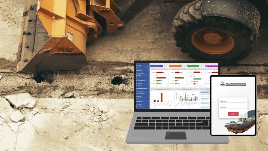
Road Condition Monitoring System(RCMS): Enhancing Efficiency with AI-Powered Solutions
The quality and sustainability of road infrastructure play a pivotal role in societal development, economic growth, and the safety of communities. To address the challenges of road construction and maintenance, advanced digital tools such as Road Condition Monitoring Systems (RCMS) are becoming indispensable. Leveraging technologies like AI-powered pothole detection, data analytics, and interactive visualization, RCMS ensures efficient planning, monitoring, and maintenance of road networks.
#ai and gis road monitoring solutions#geospatial road management solutions#geospatial road monitoring system#gis based pothole mapping and detection#gis based road condition monitoring system#gis based road inspection software#gis based road survey solutions#gis data analysis for road monitoring#gis mapping for road condition analysis#gis road maintenance solutions#land management system#gis tools for road condition assessment#pothole detection using gis technology#real time road condition monitoring gis#road condition assessment using gis#road condition monitoring using gis#road infrastructure monitoring with gis#road maintenance gis software#road safety monitoring with gis systems#road surface monitoring with gis#smart road condition monitoring gis
1 note
·
View note
Text
Geospatial Intelligence helps in informed decision-making and strategic planning. It enables authorities to predict and respond to challenges more effectively.
For More Information:-
https://www.xbyte.io/geospatial-intelligence-navigating-the-future-of-data-analysis/
0 notes
Note
Mormons!!?!?
https://www.rawstory.com/news/kamala-harris-mormons/
A group of Kamala Harris supporters convened in a virtual call Tuesday evening. It was an eclectic mix with attorneys, lawmakers, podcasters, singers and a mayor. There were, certainly, Democrats on the speaker lists, but also Republicans who have decided to step away from their party’s ticket this year.
What connected all of them? Their Latter-day Saint faith.
Members of The Church of Jesus Christ of Latter-day Saints may be a substantial force in presidential outcomes in deeply red Utah and battleground Arizona, according to speakers, including Mayor of Mesa, Arizona, John Giles, who is Republican, but is a vocal Harris supporter; former Democratic U.S. representative from Utah Ben McAdams; and Salt Lake City Democratic legislators Sen. Luz Escamilla and Rep. Brian King, the latter also being the Democratic gubernatorial nominee in Utah.
Data shows that Latter-day Saints are poised to support Harris “more than any other presidential Democratic ticket in 60 years,” said Jacob Rugh, an associate professor in the Department of Sociology at church-run Brigham Young University, during the call. He cited his research and past races that have moved the needle left in Utah and Maricopa County in Arizona.
“My geospatial analysis shows that areas heavy with LDS chapels in the east valley were most likely to flip blue (in 2020),” Rugh said on Tuesday. Nationwide, in 2020, 1 in 3 Latter-day Saint voters picked the Biden-Harris ticket, and the majority of the faith’s millennial and Gen Z voters chose the Democratic ticket, according to Rugh.
The 2020 Biden-Harris ticket performance in Utah “was the best of any Democratic ticket since 1964. Salt Lake County flipped blue in 2016 and, in 2020, voters did what others said was impossible by flipping four precincts blue in Provo,” Rugh said. He predicts they “will flip even more in 2024.”
There are 2.1 million members of The Church of Jesus Christ of Latter-day Saints in Utah, according to data from the church. It’s the most prominent faith in Utah, which has historically voted red. There are also more than 442,800 members in Arizona.
About 1,400 people tuned into Tuesday’s call, a first from a group called Latter-day Saints for Harris-Walz, which on its social media boasted of as many as 2,600 registrants. The event came the same day Harris announced she had picked Minnesota Gov. Tim Walz as her running mate.
The remarks from presenters, mostly from Utah and Arizona, were preceded by a prayer. Speakers also cited scripture as they spoke about the character of the Republican presidential nominee, former President Donald Trump, and to explain why, in their view, the most Latter-day Saint-aligned candidate is Harris.
Mostly, it was a discussion on how to organize to elect Harris. After all, Rob Taber, an organizer said, Latter-day Saints “from missions and ministering, (are) pretty good at reaching out to people and building bridges.”
However, Taber also advised those on the call not to use ward or stake membership lists when reaching out to people because that violates the church’s neutrality policy.
“But you can share on social media how you’re feeling. This actually does make a big difference,” Taber said.
‘Examine the character’
Ask Mesa Mayor John Giles why he decided to support a Democratic candidate and he may cite the arguments he made in an op-ed he wrote in Arizona Central criticizing Trump’s refusal to accept the outcome of the 2020 election and his disinvestment in cities like Mesa, and where he called on other Arizona Republicans to choose “country over party this election.”
But, he may also mention an admonition he heard at a Latter-day Saint church meeting that encouraged members to be good citizens, to participate in elections and to “examine the character of the candidates.”
“Man, I sincerely hope that we get that admonition this election season, because I think that would help our brothers and sisters to look with fresh eyes at this election,” Giles said on Tuesday.
Giles also cited the church’s stance on defending the U.S. Constitution and how different that perspective is from Trump’s view, he said.
Trump is “more than willing to compromise the rule of law and the United States Constitution to further his own gains,” Giles said. “I think that we have a particular mission as Latter-day Saints to step up and point those things out to our friends inside the church and outside as well.”
Some of the attendees, such as McAdams, said they vote Democrat “not in spite of our religion, but because of our religion,” arguing that “negativity, divisiveness, rage, political violence, discrimination and racism are not of God.”
Utah Senate Minority Leader Luz Escamilla said that, as she was preparing to teach Sunday School, it was clear to her that Trump may not be aligned with Latter-day Saint doctrine. She quoted Elder Dallin H. Oaks, first counselor in the church’s First Presidency.
“He said ‘knowing that we are all children of God, give us a divine vision of the worth of all others and the will and ability to rise above prejudice and racism.’ The current candidate for the Republican Party is literally working tirelessly to create prejudice and racism against Americans,” Escamilla said. “And that alone is a reason why all members of The Church of Jesus Christ of Latter-day Saints should be supporting Vice President Harris for President of the United States in the 2024 election cycle.”
Utah gubernatorial candidate Rep. Brian King also praised Harris’ running mate, arguing that Walz fits into the model he likes to see in the country’s candidates and elected officials.
“He’s the kind of candidate that leaders of our faith have called for us to support, a person of integrity, compassion, with a commitment to service,” King said. “I’m so glad that Vice President Harris has revealed her own personality so clearly in her choice of running mate.”
131 notes
·
View notes
Note
oy as a linguist linguistics is more a science than any of the social sciences in that poll. our research is replicable and our methods actually work. the only reason we haven't solved all of linguistics is because the forbidden experiment is, well, forbidden, so we have to engage in roundabout guessing games, and the comparative method isn't good enough to reconstruct proto-world.
but the field's still colonial as all hell i mean look up the summer institute for linguistics.
no it’s definitely my bad I should have included it. however this is funny because every social science discipline on that poll also thinks its the most scientific - ime economics is often described as the oldest most well established social science (lol), polisci has it in the name, sociology is credited with inventing statistics for the social world (and with standardised datasets like census data you can make the same claim about replicability), geography has cadastrals & land surveys & geospatial analysis (also replicable), psychology loves inventing diagnostic manuals, and anthropology’s big research method (ethnography) is normatively positioned as like academic journalism, it’s the ‘deepest’ form of qualitative research
39 notes
·
View notes
Text
Baseline Survey for CSR Program by M2i Consulting: Laying the Foundation for Impactful Initiatives
Corporate Social Responsibility (CSR) programs play a crucial role in driving social and economic development. However, for these programs to be truly effective, they must be based on a clear understanding of the community’s needs, existing challenges, and potential opportunities. This is where a baseline survey for CSR programs becomes essential. M2i Consulting, a trusted name in social impact assessments, specializes in conducting comprehensive baseline surveys to ensure CSR initiatives create meaningful and measurable change.
What is a Baseline Survey for CSR?
A baseline survey is an initial assessment conducted before the implementation of a CSR program. It gathers essential data on socio-economic conditions, demographic details, and key indicators relevant to the initiative. This survey acts as a reference point, allowing organizations to track progress and measure the impact of their CSR activities over time.
Importance of Baseline Surveys in CSR Programs
Informed Decision-Making – A baseline survey provides valuable insights that help companies design targeted and effective CSR interventions.
Resource Optimization – Understanding the real needs of the community ensures that funds and efforts are directed toward the most critical areas.
Impact Measurement – By comparing pre- and post-intervention data, organizations can evaluate the success of their CSR initiatives.
Stakeholder Engagement – A well-executed survey helps in gaining community trust and participation, making CSR programs more sustainable.
Regulatory Compliance – Many governments and regulatory bodies require companies to demonstrate the impact of their CSR initiatives, making baseline surveys a necessity.
How M2i Consulting Conducts Baseline Surveys
At M2i Consulting, we follow a structured and data-driven approach to conducting baseline surveys for CSR programs:
Defining Objectives
We begin by understanding the CSR goals of the organization and identifying key impact areas that need assessment.
Designing the Survey Framework
Our team develops a detailed survey framework, including qualitative and quantitative research methods, to capture relevant data effectively.
Data Collection
Using tools such as field interviews, focus group discussions, and digital surveys, we gather comprehensive data from targeted communities.
Data Analysis & Reporting
We analyze the collected data to identify key insights, trends, and potential challenges that may affect CSR program implementation.
Recommendations & Strategy Development
Based on our findings, we provide actionable recommendations to help organizations structure their CSR programs for maximum impact.
Why Choose M2i Consulting for Baseline Surveys?
Expertise in Social Research – With years of experience in impact assessment, M2i Consulting ensures reliable and accurate data collection.
Custom-Tailored Solutions – We design surveys that align with specific CSR objectives and industry requirements.
Use of Advanced Tools & Methodologies – Our approach integrates modern research techniques, including data analytics and geospatial mapping.
Commitment to Social Impact – We are dedicated to helping organizations create sustainable and transformative CSR initiatives.
Conclusion
A baseline survey for CSR programs is an indispensable step in designing and executing impactful social initiatives. By partnering with M2i Consulting, organizations can ensure that their CSR efforts are evidence-based, goal-oriented, and aligned with the real needs of communities. Our expertise in conducting baseline surveys helps businesses maximize their social impact while fulfilling corporate and regulatory responsibilities.
Are you planning a CSR initiative and need a baseline survey? Get in touch with M2i Consulting today to lay the foundation for a successful and sustainable CSR program!
8 notes
·
View notes
Text
youtube
'Only Americans can do it': Why Ukrainians can’t launch ATACMS alone
'Only Americans can do it': Why Ukrainians can’t launch ATACMS alone
The US is getting bogged down in the Ukraine conflict despite assertions to the contrary.
"American servicemen are involved in [ATACMS] missile guidance... and coordinating their flights to deliver the strike. We can say this with complete confidence," Alexander Mikhailov, head of Russia's Bureau of Military-Political Analysis, tells Sputnik.
Five US-made Army Tactical Missile System (ATACMS) missiles were intercepted and one was damaged by S-400 and Pantsir air defense systems on November 19, as Ukrainian forces launched six missiles at Russia's Bryansk region at 3:25 am.
The pundit explains that:
▪️US-made ATACMS use satellite navigation data that is provided by the US military -target selection and their coordinates is carried out by US military-technical specialists
▪️the process of loading the flight mission into the missile's guidance head is conducted by US soldiers
"The launch cannot be carried out without the American officers," says Mikhailov, "[Americans] wouldn't transfer either the algorithms, or the codes, or the mechanisms for entering coordinates into the ATACMS missiles to officers of the Ukrainian Armed Forces. "
American security experts echo the Russian scholar. Speaking on the Judging Freedom podcast on Tuesday, former Marine Corps intelligence officer Scott Ritter stated that "ATACMS cannot be operated by anyone but the US":
▪️the guidance system and the data that is going in is developed by the Pentagon's geospatial analysts in Europe
▪️the data, classified using National Security Agency cryptology, is communicated from the European site to a downlink station in Ukraine manned by US specialists
▪️it then is loaded up on the ATACMS again by US specialists "So the mission is planned by the US, the data is loaded into the missile and when the button is fired it's being... fired by the US against Russia," Ritter says. "Only Americans can do it. "
The Kremlin has repeatedly warned the US against growing involvement in the Ukraine conflict. Kremlin spokesman Dmitry Peskov has said that the US greenlighting Ukraine's strikes deep inside Russia with ATACMS means "a qualitatively" new situation in terms of Washington's involvement.
Boost us! | Subscribe to @geopolitics_live
Source: Telegram "geopolitics_live"

5 notes
·
View notes
Text
"
Thousands of data points from CSIRO and the Bureau of Meteorology’s Climate Change in Australia project were analysed by the geospatial team Spatial Vision, who worked alongside the Climate Council to develop a new interactive heat map tool.
The map projects the average number of hot and very hot days, as well as very hot nights, for each Australian suburb by 2050 and 2090 under three scenarios:
No action, where global emissions rise throughout the 21st century
Existing action, what we’d see if all countries meet their current commitments for emission reductions
Necessary action, a much stronger pathway that requires almost all countries, including Australia, to substantially strengthen their existing climate commitments and actions.
Any Australian can input their suburb or postcode to the heat map, to see how stronger action on climate pollution can affect the heat in their area. "
How will you survive a hotter city?
#jail climate criminals#we want climate action now#climate change#cambio climático#climate crisis#prepare for climate change#greenwashing#big oil#fossil fuel industry#plastic#climate washing#floods#climate activism#calentamiento global#medio ambiente#IPPC#climate hope#sea level rise#late stage capitalism#victims of capitalism#klimakatastrophe#klimawandel#changement climatique#qihou bianhua#izmeneniye klimata#cambiamento climatico#気候変動#जलवायु परिवर्तन#jalavaayu parivartan#das Alterações Climáticas
5 notes
·
View notes
Text
Top 5 GIS Toolboxes: Unlocking the Full Potential of Geographic Information Systems
Geographic Information Systems (GIS) have become indispensable in urban planning, environmental protection, engineering, and other fields. With advancements in technology, various GIS toolboxes have emerged, helping users achieve more efficient data processing and 3D visualization. This article introduces five top GIS toolboxes to help you choose the best solution for your needs.
1. GISBox
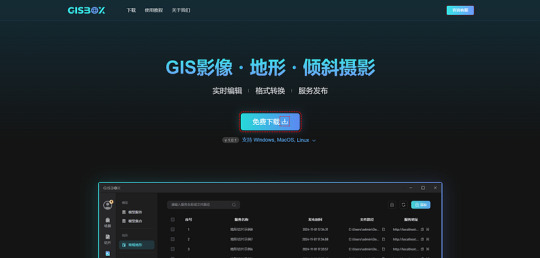
GISBox is a comprehensive GIS toolbox that integrates data processing, spatial analysis, and 3D visualization functions. A standout feature of GISBox is its efficient real-time editing capabilities, such as photogrammetric mesh repairs, riverbed depressions, and terrain alignment, which significantly simplify complex 3D terrain data processing workflows. Additionally, GISBox supports various mainstream publishing protocols, including 3DTiles, Terrain, and WMTS, offering a range of options for different users. Whether for small to medium-sized enterprises or individual projects, GISBox provides an all-in-one solution to efficiently handle GIS data processing and publishing tasks.
Pros:
· Supports multiple data formats.
· User-friendly plugin system for easy extension.
· Powerful 3D visualization and data processing capabilities.
2. QGIS (Quantum GIS)
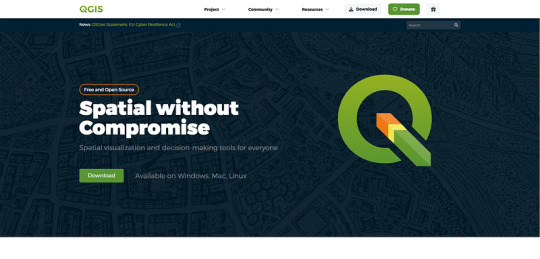
QGIS is an open-source and highly customizable GIS tool widely popular among users globally. Its rich plugin ecosystem caters to various GIS needs, from basic map creation to complex spatial analysis.
Pros:
· Free and open-source, with an active user and developer community.
· Rich in plugins with strong extensibility.
· Highly customizable interface and workflow.
3. ArcGIS

Developed by Esri, ArcGIS is a professional GIS platform with a toolbox that provides hundreds of tools for geographic data analysis and map creation. It integrates data collection, processing, analysis, and visualization, making it the top choice for solving complex geographic problems.
Pros:
· Extensive data processing and analysis tools.
· Integration with other Esri products for a complete GIS workflow.
· Professional technical support and learning resources.
4. Global Mapper
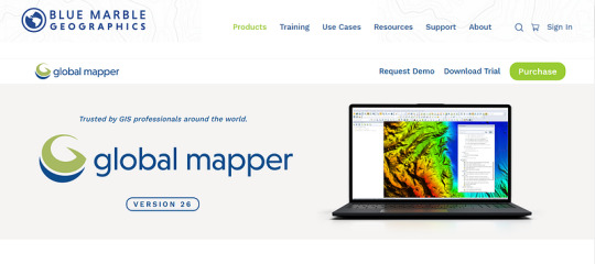
Global Mapper is a comprehensive GIS software that supports a wide range of geographic data formats and powerful data processing functions. Known for its simplicity and affordability, it is suitable for users looking to quickly perform spatial analysis and data visualization.
Pros:
· Supports multiple data formats with robust data conversion capabilities.
· Gentle learning curve for easy onboarding.
· Comprehensive functionality suitable for projects of various scales.
5. SuperMap iDesktop

SuperMap iDesktop is a powerful GIS desktop tool that provides a full suite of tools for spatial analysis, data management, and 3D visualization. It is widely used in industries like urban planning, environmental monitoring, and infrastructure management. SuperMap iDesktop integrates a variety of data formats and supports a range of powerful GIS functions, including advanced 3D terrain modeling, geospatial analysis, and the ability to handle large datasets with ease.
Pros:
Advanced 3D modeling capabilities for creating and analyzing detailed terrain models.
Supports a wide variety of data formats, including raster, vector, and 3D data.
Comprehensive spatial analysis tools and detailed reporting features.
User-friendly interface, suitable for both novice and experienced GIS professionals.
Conclusion
Whether you are a beginner or an experienced GIS user, these toolboxes can provide excellent support for your projects. Software like GISBox and Cesiumlab is highly regarded for its exceptional 3D rendering and data management capabilities, while QGIS and Global Mapper are popular for their flexibility and ease of use. Selecting the right tool based on your specific project requirements and budget will help boost your work efficiency and enrich your geographic data presentations.
1 note
·
View note
Text
Maximize Your Fleet Safety with Video Telematics Solutions

Video evidence has consistently proven to be essential in gathering and storing information, especially for businesses engaged in fleet management. More specifically, we are referring to the effective utilization of video telematics.
In recent years, numerous industries have experienced remarkable technological advancements, and the transportation sector has particularly embraced video telematics as a remarkable innovation.
Here is a comprehensive guide that will enable you to acquire a thorough understanding of video telematics solutions.
Table of Contents
What is Vedio Telematics?
DMS- ADAS: The Core Components of Video Telematics Solutions
How do Video Telematics Solutions Operate?
Benefits of Video Telematics Solutions
(1) Driver Monitoring
(2) Real-time Live Streaming
(3) Opportunities for Driver Training
(4) Surveillance for Security
What is Vedio Telematics?
Video telematics is an advanced version of vehicle telematics that combines visual data, vehicle analysis, and geospatial vision. Unlike traditional automotive telematics solutions that only send text alerts to managers, video telematics solutions also capture video data.
The integration of video telematics into fleet management software has greatly improved its capabilities. In addition to real-time location tracking, the software now collects vast amounts of data and provides valuable insights into vehicles through its sensors Dashboard camera records the driver’s actions, while the video sensor captures the environment surrounded both externally and internally. These environmental factors include the speed of nearby vehicles, the behavior of the driver, and the environment around the vehicle.
DMS- ADAS: The Core Components of Video Telematics Solutions
The Driver Management System (DMS) and Advanced Driver Assistant System (ADAS) are not only the fundamental elements of Video Telematics but are also considered the essence and backbone of video telematics.
The Driver Monitoring System (DMS) is responsible for overseeing and monitoring driver behavior, while the Advanced Driver Assistance System (ADAS) aids in monitoring the surrounding road environment. Moreover, the system recognizes events rather than individual actions, categorizing them into various types such as smoking, yawning, drowsiness, and more. The dashcam captures the driver’s actions, compares them with the recognized events, and subsequently generates appropriate alerts.
In addition, fleet managers are also notified about other significant events, including the blocking of the camera, the absence of the driver from the driver’s seat, and the use of a mobile phone.
The ADAS feature not only enhances the overall functionality but also effectively detects the surrounding environment and promptly notifies the driver of any potential incidents. By incorporating the ADAS feature, insurance claim settlements, driver training, and the overall safety of the vehicle, driver, and cargo have been greatly improved. Fleet managers can be notified about events such as chances of forward collisions, red light jumping, and reckless lane switching through ADAS.
How do Video Telematics Solutions Operate?
Video telematics solutions function by combining vehicle data, driving data, real-time location, and video footage transmitted over cellular data. Whenever an event occurs, the device generates an appropriate alert. The main goal of this technology is to enhance driver safety by providing personalized data that can be used for driver training and coaching purposes.
The software primarily focuses on monitoring drivers’ behavior and identifying risky activities such as overspeeding, reckless driving, distracted driving, and more. Cameras are used to capture video footage, which provides a comprehensive understanding of driver conduct and any related issues. This enables fleet management to make well-informed decisions.
Different types of cameras are available based on the fleet’s requirements, including multi-camera, road-facing, and driver-facing cameras.
Benefits of Video Telematics Solutions
Video telematics solutions offer various benefits, particularly in the context of fleet management, safety, and operational efficiency. Here are some key advantages of implementing video telematics solutions:
(1) Driver Monitoring
Video telematics can record and analyze drivers’ behavior, promoting safer driving habits and reducing risky behaviors such as speeding, harsh braking, and aggressive driving. The solution not only analyzes driving habits but also notifies events of collisions. In such events, video footage can provide crucial information for understanding the cause of the event. Advanced video telematics solutions also provide real-time alerts to prevent collisions.
(2) Real-time Live Streaming
Video telematics systems provide real-time streaming, allowing fleet managers to monitor their fleet and the activities of drivers in real time. This solution helps address issues as they arise and improves overall operational visibility.
(3) Opportunities for Driver Training
Utilizing video footage can be an effective method for driver training and coaching. This enables fleet managers to pinpoint areas that require improvement and offer tailored training to enhance the driving skills of their drivers.
(4) Surveillance for Security
Video telematics serves as a deterrent against theft and vandalism. In case of unauthorized access or theft, video footage can assist in locating stolen vehicles and recovering the assets. Wrapping it all
In conclusion, it is undeniable that video telematics plays a vital role in organizations, particularly in fleet management. Although video telematics solutions offer a multitude of advantages, organizations must implement and utilize the system responsibly.
If you are considering acquiring advanced telematics solutions, look no further than TrackoBit. This comprehensive solution offers a 360° visual coverage of your fleet, as well as features such as route planning solutions and fuel management systems.
Source : Maximize Your Fleet Safety with Video Telematics Solutions
1 note
·
View note
Text

Gsource Technologies offers cutting-edge Lidar and Photogrammetry services, revolutionizing geospatial data acquisition and analysis. Our expertise extends across diverse applications, including Digital Terrain and Surface Models, enabling precise elevation mapping for various projects. We specialize in 3D Modeling and web viewers, providing immersive visualizations for enhanced project understanding. Feature Extractions are meticulously performed to identify and analyze key elements, ensuring comprehensive data interpretation.
Our Scan to BIM services facilitate seamless integration of Lidar data into Building Information Modeling processes, enhancing accuracy in construction and design. Additionally, we excel in 2D Linework, CAD Conversions, and Automated Contours, streamlining design workflows. Gsource Technologies' commitment to excellence is further evident in Topo Creation, where we generate detailed topographic maps to meet project specifications. With state-of-the-art technology and a skilled team, we deliver comprehensive Lidar and Photogrammetry solutions tailored to meet the evolving needs of diverse industries.
2 notes
·
View notes
Text
There are more than 114,000 missing persons in Mexico, and that number is continuing to rise. Criminal violence in the country is at a record level, largely driven by gangs and drug cartels. Many of those missing are buried in clandestine graves all across the country.
To contribute to the solution of this complex problem, a group of scientists from the Center for Research in Geospatial Information Sciences (CentroGeo) put technology and data analysis at the service of the searches.
"I never thought I would have to work on this, but if this knowledge is of any use, now is the time to show it," says José Luis Silván, a geographer at CentroGeo. Years ago, as part of his doctoral work, he specialized in measuring forest biomass and human populations through satellite information. At that time, he was far from imagining the scientific work he is doing today: investigating the potential of drones, hyperspectral images, and protocols to detect clandestine graves.
In a recent article published in the International Journal of Forensic Research and Criminology, Jorge Silván and researcher Ana Alegre insist that studying the geographical environment is very important to understand in depth a crime such as disappearance. Thus, “due to its context and diversity of climates, the case of Mexico may represent an opportunity for the development of investigations.”
Finding burials requires hard work. All available information and resources must be optimized. Therefore, scientists have evaluated the use of remote sensing tools and have systematized information from previous findings. They seek to discover patterns in the behavior of the perpetrators and, with this, to find burials.
According to Red Lupa, 88% of the 114,000 cases of disappearances in Mexico occurred between 2000 and May 2024. 10,315 were registered in 2023, the most on record. This represents an average of 29 people per day. Jalisco, Tamaulipas, State of Mexico, Veracruz and Nuevo Leon are the entities with the highest incidences.
Justice is almost non-existent, with 99% impunity for this crime. For this reason, since 2007 alone, civil society has formed more than 300 search groups, mostly made up of family members who scour the land guided by witness statements or organized in general brigades. These groups have detected most of the 5,696 clandestine graves reported on Mexican soil.
The association United for Our Disappeared searches in the north of the country, in Baja California. One of its members, who preferred to remain anonymous, has been searching for his son for 18 years. He says they have been using pointed rods to detect graves for more than 10 years. This is one of the most widely used tools in Mexico for this purpose. "We fit the rod in where we suspect the earth was removed, insert it, pull it out and smell it. If there are bone remains or tissue, you can tell by the smell. It is a strong odor, easy to detect. It smells like organic matter in the process of decomposition."
Before, he says, they used a georadar—a device similar to a pruning shear that detects inconsistencies in the ground—but they abandoned this practice because it was not very useful. The radar responds to almost any kind of object, from chips to boats. The last time they used it, it returned 40 suspicious spots, but none were positive. In Mexicali, another group uses a drone to fly over areas and detect changes in the terrain. Others have used machines to dig holes instead of shovels. Some innovations are abandoned over time, but the use of rods remains.
In 2014, after the disappearance of 43 Ayotzinapa normalistas in Mexico, Silván and other CentroGeo professionals joined the scientific advisory board on the case. During the search for the students, different civilian groups and government brigades detected dozens of illegal graves. In less than 10 months, the Mexican Attorney General's Office counted 60 sites and 129 bodies in the state of Guerrero. As a result of the raids, 300 illegal graves were revealed. Since then, the number of clandestine graves has only grown.
No one anticipated the size of this horror. The report "Searching between pain and hope: Findings of clandestine graves in Mexico 2020 - 2022", exposes with hemerographic data that in those two years, 1,134 clandestine graves were registered, with 2,314 bodies and 2,242 remains. In proportional terms, Colima reported the highest rate of illegal graves, with 10 per 100,000 inhabitants. It was followed by Sonora, Guanajuato, Guerrero, Sinaloa and Zacatecas.
By number of cases, Guanajuato, Sonora and Guerrero stand out. These three entities account for 42% of the records. By April 2023, a journalistic investigation by Quinto Elemento Lab reported that the number of illegal burials reached 5,696 clandestine graves, and that more than half of them were detected during the current federal administration.
Employing his field of study, remote sensing, José Luis Silván uses images captured with satellites, drones or airplanes, from which he extracts geospatial information using knowledge of the physics of light, mathematics and programming. Multispectral and hyperspectral images capture subsurface information using sensors that record wavelengths of light imperceptible to the human eye, making them useful for searching.
In 2016, during a first study by CentroGeo researchers, they simulated burials with pig carcasses to evaluate the potential of using hyperspectral cameras in searches and learn what information from the sensors was useful to them. The Mexican researchers knew from research in other countries that successful detection with these techniques depends, in part, on being able to recognize how carcasses (and their spectral images) change in different soils and climates.
The experiment was carried out on rented land in the state of Morelos. There they buried seven animals and evaluated the light reflected by the soil at different wavelengths for six months. They concluded that a hyperspectral camera, which provides more than a hundred layers of data, has the potential to detect clandestine burials, although the technique is only effective three months after burial. They tried to arrange for the acquisition of a camera and drone (valued at 5 million pesos) through the National Search Commission, but were unsuccessful.
Faced with this, they began to evaluate more affordable alternatives, such as multispectral devices. Today, despite the fact that spaces such as the Commission for the Search for Disappeared Persons of the State of Jalisco (COBUPEJ—-with which they have a partnership—has acquired this equipment, no national strategy exists to deploy these technologies systematically.
Some time later, the scientists took on a bigger challenge. When they briefed the National Search Commission on the usefulness of remote sensing for locating burials, officials told them that in some regions of the Northwest, the greatest need was to locate substances used to conceal crimes. "They dispose of them in caustic soda or with chemicals, char them and incinerate them in the open air or in crematoria; they throw the remains away or bury them," the researcher says.
So, in 2021, Silván's group did another experiment, this time in Hidalgo and with a spectroradiometer, which measures how different substances reflect light. For that study, they tested the trace of substances used in crimes. They found that diesel, muriatic acid and blood treated with anticoagulants require more precise imaging to be located, but that most substances, such as caustic soda, lime, blood and those resulting from open burning could be detected with multispectral sensors, which are less expensive.
CentroGeo has also participated in the development of complementary strategies to identify areas with a high probability of harboring clandestine graves. One example is the training of mathematical models with the coordinates of previous findings and the characteristics of the sites preferred by criminals, which they call clandestine spaces and which define as those which are easy to access for perpetrators and of low visibility to the population.
In addition, they have been using the signs that decomposing bodies leave on the vegetation for years. As a corpse decomposes, it releases nutrients into the soil, in particular increasing the concentration of nitrogen. In plants, this element is linked to chlorophyll, which gives them their greenness. In experiments with buried pigs, they have observed that a chlorophyll indicator can be quantified through satellite images. They measure how fast this index grows to detect sites with anomalies. This tool is available on the "Clandestine Space" platform.
Silván says that to interpret the nitrogen signal, they must consider that the gas signal can also vary due to the use of fertilizers or rains that carry nutrients. The presence of nitrogen, then, is not definitive proof of the existence of trenches, but it provides indications that justify paying attention in certain regions. The National Search Commission has been trained to use this indicator.
In Baja California, a northern state with 17,306 missing persons cases, these strategies have already been used. They first analyzed 52 locations of known graves and deduced that, because of the way they were distributed, there was a high probability of finding more graves at a distance of between 18 and 28 kilometers from those already known. They also looked for possible "clandestine spaces" and identified that 32% of the territory of Baja California had the potential to be used for that purpose. Finally, they reviewed the concentration of chlorophyll in satellite images. The result was a useful accompaniment for some family brigades.
Recently, Ana Alegre and José Silván analyzed geospatial models that could explain the distribution of graves in 10 states. They found that the travel time it would take an offender to get from urban streets to the grave is the factor that most influences the location of graves. "The secrecy sought by perpetrators seemed less important than reducing the effort they invest in creating the grave," their article says.
In addition to collaborating with the government, CentroGeo researchers work with civil associations such as Regresando a casa Morelos and Fuerzas unidas por nuestros desaparecidos en Nuevo León (FUNDENL). Some time ago, the former asked them to survey a site. "We collected thermal images and three-dimensional models to provide information," says Silván. In addition, they gave a workshop for visual interpretation. Silván describes the members of "Returning Home Morelos" as dedicated people. "They want to find their loved ones, they are willing to learn anything, to analyze an image or fly a drone. To everything."
With information from the FUNDENL collective and support from the American Jewish World Service, CentroGeo created "Huellas de vida", a platform that crosses the information of unfound persons and unidentified bodies with data from objects found in clandestine burial sites in Nuevo León. The intention is to detect coincidences that will help solve cases.
The geographer points out that the investigation is advancing, while the forms and numbers of disappearances are multiplying. Other countries, he says, are installing ground penetration radars on drones, or are planning to use electronic noses as indicators of methane, an element that corpses release at a certain stage of decomposition. To search for missing persons from the Spanish Civil War, for example, patterns in geographic data were tracked to narrow down search sites.
The big pending issue is to evaluate the real contribution that geographic information has had in uncovering crime scenes. "It is complicated to have feedback, even with the National Commission, because they are not obliged to tell us where they have findings." It will be until they have the new reports when they will be able to collate the results and measure the impact of their contributions. For now, "it is complicated to attribute the findings to our tools and information".
For his part, the member of United for our Disappeared assures that the search groups are the ones who have found most of the clandestine graves currently located. The usual thing, he says, is that the governments do not have departments for this work and only search when they have declarations that oblige them to do so. With the collectives it is different, because "we receive anonymous information, and even if we have no information, we still schedule searches and go out".
Finding graves is the beginning of another loss. When they have reason to excavate, they use picks and shovels and, if they find human remains, the authorities (who usually accompany them) cordon off the area and proceed with their work. If they are not present, they call them. "From there, many times we don't know what's going on, we don't get feedback from the authorities. We say that the person we found is lost again." The problem is general, "the collectives complain that people get lost in the bureaucratic process". In few cases, they say, the Prosecutor's Office restores the identity of the disappeared.
While technology is integrated into the systematic searches, collectives such as United for our Disappeared ask society to share the information they have on missing persons. "We only want to find them, all the information that reaches the collectives is anonymous," says the interviewee whose identity we reserve. The authorities have accepted this, he assures.
For his part, José Silván comments that, as a result of the collaboration with COBUPEJ and other institutions, they are about to publish a book to disseminate techniques for the detection of graves that they tested during their work.n de fosas que probaron durante un año en dos sitios de inhumación controlados en Jalisco, así como otras experiencias recogidas a nivel nacional a través de la ciencia ciudadana que hacen las madres buscadoras. The book is entitled Interpreting Nature to Find Them and is coordinated by Tunuari Chavez, head of the COBUPEJ context unit, and Jose Silvan under the direction of commissioner Victor Avila.
8 notes
·
View notes
Text
A Beginner’s Guide to GeoAI‑Powered Geospatial Analysis in the Cloud
The exponential growth in the quantity of geographical data from satellites, UAVs, Internet of Things (IoT) sensors, and mobile devices is making it challenging for conventional geospatial processing techniques to keep pace. To extract valuable insights at scale, GeoAI (Geographical Artificial Intelligence) combines AI/ML algorithms with geographical data. GeoAI becomes an even more potent tool when utilized in cloud-native systems, enabling automated, scalable, and real-time geospatial analysis workflows.

https://www.geowgs84.ai/post/a-beginner-s-guide-to-geoai-powered-geospatial-analysis-in-the-cloud
0 notes