#Magnetometer instrument
Explore tagged Tumblr posts
Visit Tumblr Blog
Explore Tumblr blogs with no restrictions, modern design and the best experience.
Last Seen Tumblr Blogs


Fun Fact
Tumblr has 16.74 million mobile monthly users in the US.
Video

flickr
GOES-U Launches to Space by NASA on The Commons Via Flickr: A SpaceX Falcon Heavy rocket carrying the National Oceanic and Atmospheric Administration (NOAA) GOES-U (Geostationary Operational Environmental Satellite U) lifts off from Launch Complex 39A at NASA’s Kennedy Space Center in Florida on Tuesday, June 25, 2024. The GOES-U satellite is the final satellite in the GOES-R series, which serves a critical role in providing continuous coverage of the Western Hemisphere, including monitoring tropical systems in the eastern Pacific and Atlantic oceans. On board GOES-U is a suite of seven instruments for collecting advanced imagery and atmospheric measurements, providing real-time mapping of lightning activity, and detecting approaching space weather hazards. Also onboard for the first time is the compact coronagraph that will observe the Sun’s outermost layer, called the corona, for large explosions of plasma that could produce geomagnetic solar storms. NASA Media Usage Guidelines Credit: NASA/SpaceX Image Number: KSC-20240625-PH-SPX01_0016 Date: June 25, 2024
#NASA#KSC#Kennedy Space Center#LSP#Launch Services Program#GOES-U#Geostationary Operational Environmental Satellite#spacecraft#weather satellite#GSFC#NOAA#National Oceanic and Atmospheric Administration#Advanced Baseline Imager#Magnetometer instrument#SpaceX#Falcon Heavy rocket#Lockheed Martin#L3Harris Technologies#flickr
0 notes
Note
I've not asked since I've followed you, but what part of instrument engineering do you do (if you're willing to share)? I tangentially work with a lot of instruments and every time I just ask I get to learn from folks like you
Oh hey! Sorry if this took me a bit to get to, I have no idea how long ago you sent this!
So I do instrument systems engineering, which means a lot of things depending on who you ask, but basically I work on interfaces.
It's helpful to think about the instruments, or "Payload", as separate from the vehicle, or "Spacecraft". The Spacecraft is everything we need in order to get where we're going - so solar panels and batteries, the main computer, thrusters, etc. - and the Payload is what we do when we actually get there.
I'm the interface between the Payload and the Spacecraft. So, I work with the Spacecraft team to make sure the vehicle is providing adequate power to the instruments, has the right command and telemetry protocols, heats and cools the instruments appropriately, and and reacts correctly in the event of faults.
In the other direction, I also work with the instrument teams to make sure the instruments are capable of collecting the data that the project scientists are interested in.
It's a good mix of engineering and science, which is exactly where I want to be! I'm a bit of a jack-of-all-trades, and I enjoy it. I like that I can take bite-sized pieces of areas that people spend full careers becoming experts in. I don't want to be a thermal engineer, or an electrical engineer, or a power engineer or a small-bodies asteroid scientist, but I love that I can work with and learn from all of them!
#asked and answered#What kind of instruments do you work with?#I work with a whole mix!#Kinda wherever they need someone#I've worked with a lot of cameras#but also spectrometers and magnetometers and stuff like that
13 notes
·
View notes
Text
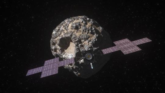
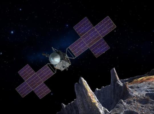
Let's Explore a Metal-Rich Asteroid 🤘
Between Mars and Jupiter, there lies a unique, metal-rich asteroid named Psyche. Psyche’s special because it looks like it is part or all of the metallic interior of a planetesimal—an early planetary building block of our solar system. For the first time, we have the chance to visit a planetary core and possibly learn more about the turbulent history that created terrestrial planets.
Here are six things to know about the mission that’s a journey into the past: Psyche.
1. Psyche could help us learn more about the origins of our solar system.
After studying data from Earth-based radar and optical telescopes, scientists believe that Psyche collided with other large bodies in space and lost its outer rocky shell. This leads scientists to think that Psyche could have a metal-rich interior, which is a building block of a rocky planet. Since we can’t pierce the core of rocky planets like Mercury, Venus, Mars, and our home planet, Earth, Psyche offers us a window into how other planets are formed.
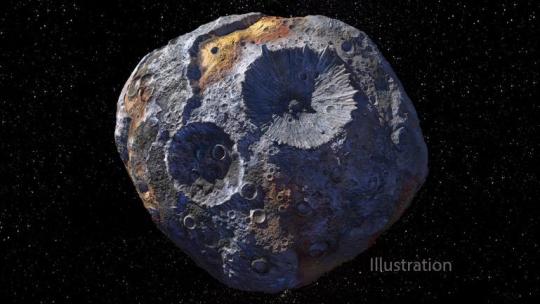
2. Psyche might be different than other objects in the solar system.
Rocks on Mars, Mercury, Venus, and Earth contain iron oxides. From afar, Psyche doesn’t seem to feature these chemical compounds, so it might have a different history of formation than other planets.
If the Psyche asteroid is leftover material from a planetary formation, scientists are excited to learn about the similarities and differences from other rocky planets. The asteroid might instead prove to be a never-before-seen solar system object. Either way, we’re prepared for the possibility of the unexpected!
3. Three science instruments and a gravity science investigation will be aboard the spacecraft.
The three instruments aboard will be a magnetometer, a gamma-ray and neutron spectrometer, and a multispectral imager. Here’s what each of them will do:
Magnetometer: Detect evidence of a magnetic field, which will tell us whether the asteroid formed from a planetary body
Gamma-ray and neutron spectrometer: Help us figure out what chemical elements Psyche is made of, and how it was formed
Multispectral imager: Gather and share information about the topography and mineral composition of Psyche
The gravity science investigation will allow scientists to determine the asteroid’s rotation, mass, and gravity field and to gain insight into the interior by analyzing the radio waves it communicates with. Then, scientists can measure how Psyche affects the spacecraft’s orbit.
4. The Psyche spacecraft will use a super-efficient propulsion system.
Psyche’s solar electric propulsion system harnesses energy from large solar arrays that convert sunlight into electricity, creating thrust. For the first time ever, we will be using Hall-effect thrusters in deep space.
5. This mission runs on collaboration.
To make this mission happen, we work together with universities, and industry and NASA to draw in resources and expertise.
NASA’s Jet Propulsion Laboratory manages the mission and is responsible for system engineering, integration, and mission operations, while NASA’s Kennedy Space Center’s Launch Services Program manages launch operations and procured the SpaceX Falcon Heavy rocket.
Working with Arizona State University (ASU) offers opportunities for students to train as future instrument or mission leads. Mission leader and Principal Investigator Lindy Elkins-Tanton is also based at ASU.
Finally, Maxar Technologies is a key commercial participant and delivered the main body of the spacecraft, as well as most of its engineering hardware systems.
6. You can be a part of the journey.
Everyone can find activities to get involved on the mission’s webpage. There's an annual internship to interpret the mission, capstone courses for undergraduate projects, and age-appropriate lessons, craft projects, and videos.
You can join us for a virtual launch experience, and, of course, you can watch the launch with us on Oct. 12, 2023, at 10:16 a.m. EDT!
For official news on the mission, follow us on social media and check out NASA’s and ASU’s Psyche websites.
Make sure to follow us on Tumblr for your regular dose of space!
#Psyche#Mission to Psyche#asteroid#NASA#exploration#technology#tech#spaceblr#solar system#space#not exactly#metalcore#but close?
2K notes
·
View notes
Note
Space probe girl who has to gradually shut off more and more of her instruments to conserve her dwindling power supply as the decades pass and she drifts farther and farther from home
the eyes are the ones that go first. they always had a narrow purpose, and it's not like she needs them to see. then her scanning platform, piece by piece. it's a unique experience, to command one's own senses to shut down- not one she'd recommend, but unique. then she loses her magnetometer, a gradual fuzzing suddenly taken out of her control. she can see the expiration date on her heart, held out exactly three metres from the perimeter of her brain, and without input she can't look away. at least she has her antennae- she has to keep listening, just in case.
17 notes
·
View notes
Video

flickr
Lava and debris brighten Mercury's surface by European Space Agency Via Flickr: This is one of a series of images taken by the ESA/JAXA BepiColombo mission on 8 January 2025 as the spacecraft sped by for its sixth and final gravity assist manoeuvre at the planet. Monitoring camera 2 (M-CAM 2) took this photo at 07:17 CET, when the spacecraft was about 2103 km from the planet’s surface. The spacecraft’s closest approach of 295 km took place on the planet's night side at 06:59 CET. The bright patch near the planet's upper edge in this image is the Nathair Facula, the aftermath of the largest volcanic explosion on Mercury. At its centre is a volcanic vent of around 40 km across that has been the site of at least three major eruptions. The explosive volcanic deposit is at least 300 km in diameter. Nathair Facula is a major target for several BepiColombo instruments, which will measure the composition of the erupted material. This will teach us about what Mercury is made of, and how the planet formed. Also visible is the relatively young Fonteyn crater, which formed a ‘mere’ 300 million years ago. Its youth is apparent from the brightness of the impact debris that radiates out from it. Older material on Mercury's surface has become much darker from weathering as it aged. Rustaveli, seen roughly in the centre of Mercury in this image, is about 200 km in diameter. Within its rim is a ring of peaks, making it a so-called peak ring basin. These peaks barely poke above smooth material on Rustaveli’s floor, which suggests the crater has been flooded by lava. Interestingly, NASA’s Messenger spacecraft detected a magnetic signal coming from Rustaveli. When molten rock such as lava or impact melt solidifies, magnetic carriers within it align with the direction of the planet's magnetic field. As the planetary magnetic field naturally changes over time, eventually the 'locked in' magnetic field in the planet's crust no longer agrees with the planetary magnetic field, something that can be detected from space. BepiColombo's two magnetometer instruments will investigate this further. In the foreground of the image, the Mercury Planetary Orbiter’s medium gain antenna (top centre) and magnetometer boom (right) are visible. [Technical details: This image of Mercury's surface was taken by M-CAM 2 onboard the Mercury Transfer Module (part of the BepiColombo spacecraft), using an exposure time of 4 millseconds. Taken from a distance of around 2103 km, the surface resolution in this photograph is around 2330 m/pixel. The image has been lightly processed; its brightness and contrast have been adjusted.] [Image description: Planet Mercury in the background with its grey, cratered, pockmarked surface. In the foreground are some spacecraft parts.] Credits: ESA/BepiColombo/MTM; CC BY-SA 3.0 IGO
#BepiColombo#Bepi#MPO#MTM#Mercury#Solar System#JAXA#Aerospace#宇宙航空研究開発機構#ISAS#MMO#水星探査計画BepiColombo#水星磁気圏探査機MMO#水星探査#ESA#European Space Agency#Space#Universe#Cosmos#Space Science#Science#Space Technology#Tech#Technology#flickr
29 notes
·
View notes
Text
Launched between August and September 1977, Voyager 1 and Voyager 2 are the oldest and most distant probes built that are still active. They are also the only probes to have left our solar system and venture into the wider expanses of space. The secret to their long life? Nuclear power. But at some point, their mission will end.
The Voyagers began as planetary missions. Their goal was to carry out the so-called Planetary Grand Tour—that is, to visit the four outer planets of the solar system through a series of flyovers. Jupiter, Saturn, Uranus, and Neptune all got a new face thanks to the probes’ robotic cameras and their many scientific instruments.
The icy giants Uranus and Neptune, in particular, were studied for the first and only time in history by Voyager 2, while successful observations of Jupiter and Saturn were the basis for subsequent interplanetary missions to these worlds, such as Galileo, Juno, and Cassini-Huygens. Voyager 1, on the other hand, had Titan—Saturn’s largest moon and one of the most intriguing satellites in the outer solar system—as its primary target.
Once the Voyagers’ planetary journeys were over, it was possible to begin a new mission phase. After their last planetary stops, both probes reached escape velocity for the solar system, allowing them to be released from the sun’s gravity. Since 2012 for Voyager 1, and 2018 for Voyager 2, they have become interstellar. We know this because after those dates, sensors on the probes showed that charged particles from the sun became less numerous and energetic than those detected from the galactic environment. This was a golden opportunity to study the boundaries of the solar system and the environment outside of it.
The Secret to a Long Life
Reaching such a distance is only possible with the right energy source. Many probes use solar panels, but if they move too far from the sun, they become useless (the farthest probe that uses them is the Juno probe orbiting Jupiter). The secret of the Voyagers lies in their atomic hearts: both are equipped with three radioisotope thermoelectric generators, or RTGs—small power generators that can produce power directly on board. Each RTG contains 24 plutonium-238 oxide spheres with a total mass of 4.5 kilograms.
Plutonium-238 is an unstable isotope, which means it undergoes radioactive decay. The plutonium atoms in the RTGs release alpha particles—comprising two protons and two neutrons—and these hit the RTG canister, heating it up. The heat is then converted into electricity.
But as time passes, the plutonium on board is depleted, and so the RTGs produce less and less energy. The Voyagers are therefore slowly dying. Nuclear batteries have a maximum lifespan of 60 years.
In order to conserve the probes’ remaining energy, the mission team is gradually shutting down the various instruments on the probes that are still active. For example, in October, Voyager 2’s plasma science instrument—which measures electrically charged atoms passing the probe—was turned off; the same device on Voyager 1 was turned off in 2007 due to a malfunction. These instruments were used to study charged particles in the sun’s magnetic field, and it is precisely this detector in 2018 that determined that Voyager 2 had exited the heliosphere and become interstellar.
Four active instruments remain, including a magnetometer as well as other instruments used to study the galactic environment, with its cosmic rays and interstellar magnetic field. But these are in their last years. In the next decade—it’s hard to say exactly when—the batteries of both probes will be drained forever.
53 notes
·
View notes
Text
SwRI is sending its first instrument to the lunar surface to survey the Moon’s interior
LMS instrument aboard the Blue Ghost Lander heading to Mare Crisium in early 2025
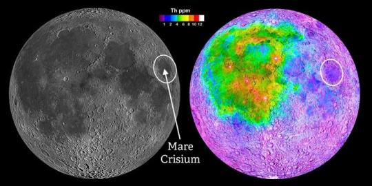
Through NASA’s Commercial Lunar Payload Services (CLPS) initiative, Southwest Research Institute developed the Lunar Magnetotelluric Sounder (LMS) to characterize the structure and composition of the Moon’s mantle by measuring electric and magnetic fields. The LMS instrument — manifested on the Blue Ghost lunar lander developed by Firefly Aerospace and targeted to launch on January 15, 2025 — will be the first SwRI instrument to touch the lunar surface. “For more than 50 years, scientists have used magnetotellurics on Earth for a wide variety of purposes, including to find oil, water, geothermal and mineral resources as well as to understand geologic processes such as the growth of continents,” said SwRI’s Dr. Robert Grimm, principal investigator of LMS. “The LMS instrument will be the first extraterrestrial application of magnetotellurics. NASA’s Artemis program is developing a series of increasingly complex missions to ultimately build a sustained human presence at the Moon for decades to come. To support these goals, LMS is part of a 14-day lunar lander mission to help understand the Moon’s subsurface in a previously unexplored location. Mare Crisium is an ancient, 350-mile-diameter impact basin that subsequently filled with lava, creating a dark spot visible to the naked eye on the Moon. Early astronomers who dubbed dark spots on the moon “maria,” Latin for seas, mistook them for actual seas. Mare Crisium stands apart from the large, connected areas of dark lava to the west where most of the Apollo missions landed. These vast, linked lava plains are now thought to be compositionally and structurally anomalous with respect to the rest of the Moon. From this separate vantage point, LMS may provide the first geophysical measurements representative of most of the Moon. Magnetotellurics uses natural variations in surface electric and magnetic fields to calculate how easily electricity flows in subsurface materials, which can reveal their composition and structure. LMS will allow scientists to probe the interior of the Moon to depths up to 700 miles or two-thirds of the lunar radius. The measurements will shed light on the material differentiation and thermal history of our Moon, a cornerstone to understanding the evolution of solid worlds. The LMS instrument ejects cables with electrodes at 90-degree angles to each other and distances up to 60 feet. The instrument measures voltages across opposite pairs of electrodes, much like the probes of a conventional voltmeter. The magnetometer is deployed via an extendable mast to reduce interference from the lander. The method reveals a vertical profile of the electrical conductivity, providing insight into the temperature and composition of the penetrated materials in the lunar interior. “The five individual subsystems of LMS, together with connecting cables, weigh about 14 pounds and consume about 11 watts of power,” Grimm said. “While stowed, each electrode is surrounded by a ‘yarn ball’ of cable, so the assembly is roughly spherical and the size of a softball.” The LMS payload was funded for delivery to the lunar surface through NASA’s CLPS initiative. SwRI designed the instrument, built the electronics box and leads the science investigation. Goddard Space Flight Center provided the LMS magnetometer to measure the magnetic fields, and Heliospace Corp. provided the magnetometer mast and four electrodes used to measure the electrical fields. Under the CLPS model, NASA is investing in commercial delivery services to the Moon to enable industry growth and support long-term lunar exploration. As a primary customer for CLPS deliveries, NASA aims to be one of many customers on future flights. NASA’s Marshall Space Flight Center in Huntsville, Alabama, manages the development of seven of the 10 CLPS payloads carried on Firefly’s Blue Ghost lunar lander.
TOP IMAGE: From within the Mare Crisium impact basin, the SwRI-led Lunar Magnetotelluric Sounder (LMS) may provide the first geophysical measurements representative of the bulk of the Moon. Most of the Apollo missions landed in the region of linked maria to the west (left image), whose crust was later shown to be compositionally distinct (right image) as exemplified by the concentration of the element thorium. Mare Crisium provides a smooth landing site on the near side of the Moon outside of this anomalous region. Credit NASA
LOWER IMAGE: LMSwRI led the development of the LMS instrument for the Mare Crisium lander mission, which includes (from left) a magnetometer, a central electronics box and four spring-launched electrodes. Credit Southwest Research Institute
7 notes
·
View notes
Photo
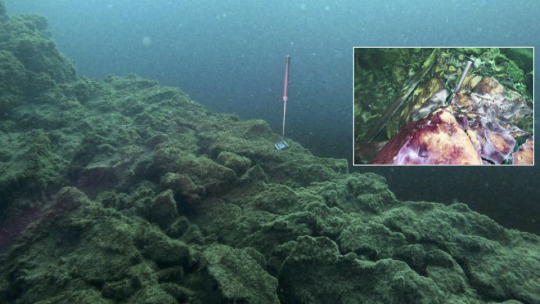
Gaging an Underwater Waterfall
Dear AGU,
Ground water venting from sublacustrine karst sinkholes in the Laurentian Great Lakes has unique properties: high dissolved salt (including sulfate) from wafting through Paleozoic marine evaporites, low oxygen due to microbial respiration during the long sub-terranean transit, and a low and steady millennium-average aboveground temperature of ~9oC. At the Middle Island Sinkhole (Lake Huron), groundwater that is denser than the overlying lake water fills the bottom of a ~23 m deep, 10 m wide bowl-shaped nearshore sinkhole. It then spills over the bowl’s sill at ~14 m into the amphitheater-like wider lake floor that is at ~ 25 m – a vertical drop of ~9 m – as an underwater waterfall! Here, the high-sulfur, low-oxygen waterfall – whose flow rate is yet to be quantified – nurtures a dynamic photo- and chemosynthetic microbial mat world.
To deepen our understanding of this underwater waterfall (other than the fun fact that divers could have fun sliding down the fall), we deployed 2 tilt-meters (Lowell Instruments TCM-1) equipped with a 3-axis accelerometer + magnetometer for continuously logging flow rate and direction: one at the edge of the sill and the other in the middle of the fall (inset) – already leaning in the direction of flow. Wonder what secrets the time-series data will reveal when we retrieve the tilt-meters next year: Is the flow steady or erratic? Do peak flows coincide with overland precipitation events? Are flow rate and mat growth in synch? How vulnerable are mat ecosystems to the vagaries of groundwater flux as the climate overhead changes?
— Phil Hartmeyer, NOAA-Ocean Exploration; Cassandra Sadler, Andi Yoxsimer, NOAA-Thunder Bay National Marine Sanctuary; Steve Ruberg, NOAA-Great Lakes Environmental Research Laboratory; Bopi Biddanda, GVSU-Annis Water Resources Institute, Michigan.
2 notes
·
View notes
Text
21st Thursday
Very fine. Term day at the Observatory: hauled the seine. A brig from Hobart Town came in brought a few letters.
Campbell's notes: Terms or stated days of the German Magnetic Association on which every European magnetic observatory took observations, occurred four times a year. Observatories were established at Altona, Augsburg, Berlin, Bonn, Brunswick, Breda, Breslau, Cassel, Copenhagen, Dublin, Freyberg, Göttingen, Greenwich, Halle, Kazan, Cracow, Leipsic, Milan, Marburg, Naples, St. Petersburg, and Upsala. In addition Ross was ordered to establish observatories at St. Helena, The Cape of Good Hope and in Van Diemen's land (Tasmania). Report, pp. 1–16. Observations of dip, horizontal direction and intensity were to be taken. Ross records for the first Term Day, ‘we obtained a very complete and satisfactory series of observations throughout the 27th and 28th of August [1840], with two sets of magnetometers, in which three instruments of each were simultaneously recorded at every interval of two and a half minutes throughout the twenty-four hours.’ Ross, Voyage, I, p. 111.
2 notes
·
View notes
Text
Titanic Mission To Map Wreck In Greatest-Ever Detail
— By Jonathan Amos & Alison Francis | 12 July 2024
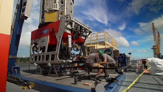
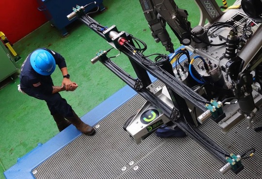
Six-tonne robots will spend up to 20 days mapping and cataloguing the wreck site
A team of imaging experts, scientists and historians set sail for the Titanic on Friday to gather the most detailed photographic record ever made of the wreck.
The BBC had exclusive access to expedition members in the US city of Providence, Rhode Island, as they made preparations to leave port.
They'll be using state of the art technology to scan every nook and cranny of the famous liner to gain new insights into its sinking.
This is the first commercial mission to Titanic since last year's OceanGate tragedy. Five men died while trying to visit the lost ship in a novel submersible.
A joint memorial service will be held at sea in the coming days for them and the 1,500 passengers and crew who went down with Titanic in 1912.
The new expedition is being mounted by the US company that has sole salvage rights and which to date has brought up some 5,500 objects from the wreck.
But this latest visit is purely a reconnaissance mission, says RMS Titanic Inc, based in Atlanta, Georgia.
Two robotic vehicles will dive to the ocean bottom to capture millions of high-resolution photographs and to make a 3D model of all the debris.
"We want to see the wreck with a clarity and precision that's never before been achieved," explained co-expedition lead David Gallo.

Titanic was the largest and most luxurious passenger ship of its day
The logistics ship Dino Chouest is going to be the base for operations out in the North Atlantic.
Weather permitting, it should spend 20 days above the wreck, which lies in 3,800m (12,500ft) of water.
It will be a poignant few weeks for all involved.
One of the five who died on the OceanGate sub was Frenchman Paul-Henri ("PH") Nargeolet. He was the director of research at RMS Titanic Inc and was due to lead this expedition.
A plaque will be laid on the seabed in his honour.
"It's tough but the thing about exploration is that there's an urge and a drive to keep going. And we're doing that because of that passion PH had for continuous exploration," explained friend and historian Rory Golden, who will be "chief morale officer" on Dino Chouest.
On its last visit in 2010, RMS Titanic Inc made a sonar map of the wreck site
There can be few people on Earth who don't know the story of the supposedly unsinkable Titanic and how it was holed by an iceberg, east of Canada, on the night of 15 April 1912.
There are countless books, movies and documentaries about the event.
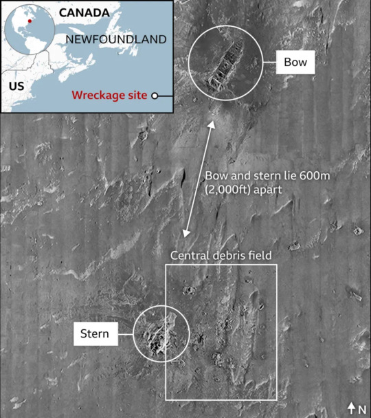
But although the wreck site has been the target of repeated study since its discovery in 1985, there still isn't what could be described as a definitive map.
And while the bow and stern sections of the broken ship are reasonably well understood, there are extensive areas of the surrounding debris field that have received only cursory inspection.

There is still much to learn about Titanic, even its famous bow
Two six-tonne remotely operated vehicles (ROVs) intend to put that right. One will be fitted with an array of ultra-high-definition optical cameras and a special lighting system; the other will carry a sensor package that includes a lidar (laser) scanner.
Together, they'll track back and forth across a 1.3km-by-0.97km section of seafloor.
Evan Kovacs, who's in charge of the imaging programme, says his camera systems should produce millimetre resolution.
"If all of the weather gods, the computer gods, the ROV gods, the camera gods - if all those gods align, we should be able to capture Titanic and the wreck site in as close to digital perfection as you can get. You would be able to quite literally count grains of sand," he told BBC News.
Powerful cameras should return unprecedented detail from the deep
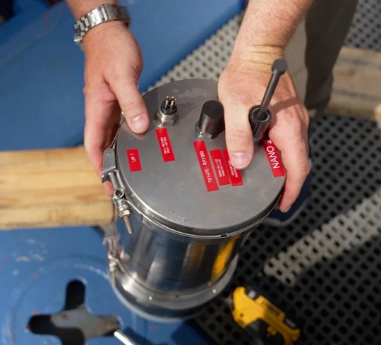
There's huge anticipation for what the magnetometer aboard the sensor ROV might produce. This is a first for Titanic.
The instrument will detect all the metals at the wreck site, even material that is buried out of sight in the sediment.
The sensor instruments, including the magnetometer, will return fascinating new data
"It would be an absolute dream to determine what has happened with Titanic's bow below the seafloor," explained geophysics engineer Alison Proctor.
"Hopefully, we'll be able to deduce whether or not the bow was crushed when it hit the seabed, or if it might actually extend down well into the sediment intact."
The team wants to review the state of some well known objects in the debris field, such as the boilers that spilled out as the opulent steamliner broke in half.

A rendering of what the electric candelabra might have looked like
There's the desire, too, to locate items thought to have been sighted on previous visits. These include an electric candelabra, which in its day would have been a fascinating curio, as well as the possibility of a second Steinway grand piano.
The musical instrument's wooden surround would have long since decayed away, but the cast iron plate, or frame, that held the strings should still be there, and perhaps even some of the keys.
"For me, it's the passengers' possessions, especially their bags, that are of greatest interest," said Tomasina Ray, who curates the collection of Titanic artefacts held by the company.
"It's their belongings - if we are able to retrieve more in the future - that help flesh out their stories. For so many passengers, they are just names on a list, and it's a way to keep them meaningful."
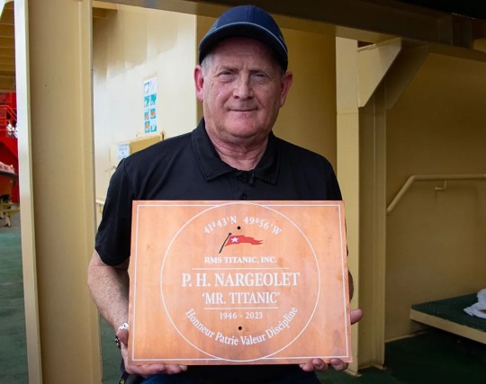
Rory Golden says the memorial plaque for PH will be placed upright in the sediment
This will be RMS Titanic Inc's ninth visit to the wreck site. The firm has attracted controversy in recent years with its stated desire to try to bring up part of the Marconi radio equipment that transmitted the distress calls on the night of the sinking.
It won't happen on this expedition but if and when it does occur, it would mean extracting an object from inside the disintegrating ship.
For many, Titanic is the gravesite to the 1,500 who died that night in 1912 and should not be touched, its interior especially.
"We get that and understand it," said company researcher James Penca.
"We dive to Titanic to learn as much as we can from her; and like you should with any archaeological site, we do it with the utmost respect. But to leave her alone, to just let her passengers and crew be lost to history - that would be the biggest tragedy of all."

It is the personal items, some preserved inside bags, that tell the stories of the dead

James Penca has the famous ship's radio call sign - "MGY" in morse code - tattooed on his arm
— Additional Reporting By Rebecca Morelle and Kevin Church
#Science & Environment#Shipwrecks#Photography#RMS Titanic#Atlantic Ocean 🌊#Titanic Mission#Map Wreck#Greatest-Ever Detail
2 notes
·
View notes
Link
After over 70 successful flights, a broken rotor ended the remarkable and groundbreaking Ingenuity helicopter mission on Mars. Now, NASA is considering how a larger, more capable helicopter could be an airborne geologist on the Red Planet. For the past several years scientists and engineers have been working on the concept, proposing a six-rotor hexacopter that would be about the size of the Perseverance rover. Called the Mars Science Helicopter (MSH), it would not only serve as an aerial scout for a future rover, but more importantly, it could also carry up to 5 kg (11 lbs) of science instruments aloft in the thin Martian atmosphere and land in terrain that a rover can’t reach. A new paper presented at the March 2024 Lunar and Planetary Science Conference outlines the geology work that such a helicopter could accomplish. The paper, “Unraveling the Origin and Petrology of the Martian Crust with a Helicopter,” notes there are several outstanding questions about the makeup and history of Mars’ surface, especially with recent discoveries of unexpected dichotomies in the composition of basaltic rocks. In observations from the Mars rovers and orbital spacecraft, some regions appear to have been influenced by water while some have not. “Up to last decade, we thought that magmatic rocks were only basaltic on Mars,” said Valerie Payré from the University of Iowa, the paper’s lead author. “But with recent rover and orbital measurements, we observed that there is a wide diversity of magmatic rocks similar to what we see on Earth.” Payré explained via email that there are rocks on Mars with elevated silica concentrations called felsic rocks – feldspar and silicate — that are rich in elements and were not expected to be found on the Martian surface. “We measured these with the Curiosity rover and have some hints of where there might be others using orbital measurements,” Payré said. “However, close-up images (millimetric scale) and composition analyses are lacking from the orbital dataset to know if these felsic rocks are widespread on Mars or just at a few locations. This is yet highly important to understand what the crust of Mars is made of and if it is similar to Earth’s crust, which has implications regarding the formation of the planet and even past climate.” First X-ray view of Martian soil – feldspar, pyroxenes, olivine revealed (Curiosity rover at “Rocknest”, October 17, 2012). Credit: NASA/JPL-Caltech/Ames Payré and her team feel that a helicopter would be perfect to explore places where a rover could never traverse, such as terrains that are too high in altitude, since landing there would require too much fuel. The instruments they propose include a miniaturized visible and near-infrared (VNIR) spectrometer for small scale mineralogical mapping and a small Laser Induced Breakdown Spectrometer (LIBS) with a micro-imager, an instrument similar to the ChemCam laser instrument on both the Curiosity and Perseverance rovers. In their paper, the team writes that a helicopter with these instruments could travel kilometers to detect promising felsic terrains, and measure their composition at a micron scale. “We could fly over these possible felsic terrains and look at their minerals using a visible/near infrared spectrometer, land on locations of interest, take close-up images, and measure the compositions of these rocks with the LIBS,” Payré said. “We could finally know what Mars’ crust is, and better constrain how it formed.” A graphic show the parts of the Ingenuity helicopter. Credit: NASA There could also be an onboard a magnetometer, which measures magnetic field anomalies, to better understand how Mars’ magnetic field operated, which is still uncertain. Mars does not presently have a global magnetic field, but had one early in its lifetime. “Such payload would finally enable us to better understand the past climate on Mars by measuring the composition and minerals of sedimentary rocks of various age,” Payré told Universe Today. A conceptual design paper published in 2020 proposed a Mars hexacopter with a mass of about 31 kg (70 lbs) and a total diameter of just over four meters (13 feet). Each set of rotors would have blades about 0.64 meters (2 ft) long. The helicopter would be powered by a rechargeable solar cell. This would not only power the rotors, but the desired scientific instruments. A model of NASA’s Mars Science Helicopter concept. Credit: NASA. This helicopter could move as fast as 30 meters a second (60 mph) but also could hover over a spot for as long as five minutes. Engineers from Ames Research Center, the Jet Propulsion Lab and the University of Maryland wrote that MSH could fly with a range of up to 10 km (6.2 miles) per flight. With this speed and range, MSH could potentially cover as much ground in a few days as rovers like Perseverance and Curiosity have traversed in years. “The fact that a helicopter can fly would facilitate the mission to visit to places that would be inaccessible for a rover, and we could access locations that we never imagined before,” Payré said. Payré and team proposed several landing sites including Gale Crater Gale crater where evolved felsic rocks were found by the Curiosity Rover; the massive canyon of Valles Marineris, where orbital observations have revealed a deep crust with feldspar-bearing rocks; and Hellas basin, 2,300 km impact crater known to have layers of feldspar. Annotated view of Valles Marineris from the High-Resolution Stereoscopic Camera (HRSC) on the Mars Express spacecraft. Credit: ESA/DLR/FU Berlin (G. Michael) The post The Mars Science Helicopter Could be an Airborne Geologist on Mars appeared first on Universe Today.
3 notes
·
View notes
Text
SandboxAQ AQNav & Acubed For Quantum Magnetic Navigation

Acubed and SandboxAQ Announce Aviation Safety Magnetic Navigation Advances
SandboxAQ and Acubed, Airbus' Silicon Valley research centre, have made significant quantum magnetic navigation (MagNav) advances, enhancing aircraft safety and resilience. These advances, which centre on their AI-powered AQNav system, will usher in a new era of intelligent automation in the sky by protecting against GNSS denial, jamming, and spoofing.
Critical global challenge addressed
GNSS disruptions can threaten flight operations and safety worldwide, rendering aviation more vulnerable. AQNav's rigorous R&D is driven by this critical concern. The quantum sensors of AQNav were developed in 2021 by quantum technology leader SandboxAQ. The technology has garnered notice as one of TIME's Best Inventions of 2024 and ACT-IAC's 2025 Innovations Champion Award.
Precision quantum magnetometers allow AQNav to “read” Earth's crustal magnetic anomalies like a geophysical fingerprint. It uses Large Quantitative Models (LQMs) to efficiently reduce electromagnetic interference to locate aircraft locations without satellite signals for accuracy.
Thorough Testing and Unmatched Accuracy
SandboxAQ has collaborated with U.S. AQNav will be thoroughly tested and improved by the USAF and partners. After demonstrating real-time navigation skills during USAF flight testing last July, the technology was admitted into the 2025 NATO DIANA cohort to improve its capabilities.
Today, a nationwide project with Acubed's Flight Lab to assess AQNav's navigational accuracy revealed noteworthy discoveries. Goals included testing magnetic anomaly-aided navigation against the aviation industry's demanding Required Navigation Performance (RNP) standards. These requirements are necessary for military, commercial, and passenger aircraft to use the system.
Even on extended flights, AQNav excelled en route accuracy between airports, proving its outstanding precision in tests. Flight data was collected, reprocessed, and streamed in real time to ensure system viability in real-world operations. This supplied useful statistics for team evaluation.
Real-World Robustness
The operational realism in their design distinguishes these test results. Acubed and SandboxAQ created tests to simulate the “noisy, messy, and unpredictable environments real pilots face every day,” said Elijha Williams, AQNav's technical engagement manager. The highlights of these strong testing were:
A publicly available Beechcraft Baron 58 was used to test AQNav instead of a geosurvey platform. AQNav instrumentation was integrated with minimal aircraft modification, avoiding electromagnetic shielding and noise isolation. AQNav's software kept a clean magnetic signal despite internal interference, and all sensors were strategically located throughout the aircraft. For all flights across the US, Canada, Mexico, and oceans, researchers used the North American Magnetic Anomaly Map (NAMAM). Flight operations included more than 200 continental US airports on a range of operationally critical routes. Importantly, not filtering routes by favourable geomagnetic gradients, map quality, or magnetic anomaly strength tested the system's adaptability. Over 150 flying hours were recorded. Diverse Geophysical Environments: Data was collected from sparsely populated plains to magnetically rich mountainous regions to adequately depict the diverse geographies where aeroplanes operate without GNSS. Genuine Operational Noise Handling: AQNav effectively removed aircraft-generated electromagnetic, vibrational, and other airframe-induced noise. AQNav always outperformed the INS without GNSS in test flights over two hours. AQNav achieved its highest accuracy of less than 74 meters, or two-thirds the length of an American football pitch, during a one-hour flight over tough mountainous and forested terrain in California.
AQNav Sandbox
SandboxAQ, the first dual-use magnetic navigation system, sends real-time positioning data to U.S. iPads. US Air Force aircraft. It has a unique roll-on/roll-off feature that offers live position information during uncontrolled, operational flights.
In 2023, the USAF awarded SandboxAQ a Direct-to-Phase-II Small Business Innovation Research contract to study magnetic anomaly navigation. It completed the AQNav system's initial flight tests eight months early. It contains the largest public Magnetic Navigation database. AQNav has flown 40 missions and 200 hours in four aircraft, from single-engine commercial planes to massive military transports. More flight testing are coming.
In addition to the USAF, Airbus' Silicon Valley R&D centre, Boeing, and other allies are interested in AQNav. The companies are assessing the technology at various phases.
How AQNav Works
AQNav uses sensitive quantum magnetometers to collect data from Earth's crustal magnetic field, which has immutable patterns like human fingerprints and is spatially different.
Comparing this data with magnetic maps utilising unique AI algorithms lets the machine locate itself quickly and accurately. Because quantum sensors are sensitive, AI algorithms boost the signal-to-noise ratio and minimise mechanical, electrical, and other interference that could impair the system's position determination.
Unjammable/Unspoofable Worldwide Signal: Earth's crustal magnetic field is everywhere and provides unfettered access and a dependable signal. AQNav works well as a supplement to other navigation systems because it is weather- and lighting-independent. land Agnostic: AQNav can navigate in the air, over open sea, on distant land, underwater, and underground without visual ground characteristics. Passive Technology: AQNav passively receives geomagnetic data without emitting or reflecting signals to reduce vehicle detection. Flexible, Adaptable Technology: AQNav functions at room temperature without shielding and can be fitted into single-engine and multi-engine airliners. Seamless Integration: AQNav can interface with inertial, visual, satellite, and other cutting-edge navigation systems to create a “system of systems” for safe and precise navigation. See also Density Matrix Embedding Theory & SQD for Quantum Modelling.
Setting the Stage for GNSS Independence
Due to this big effort, aviation has adopted AQNav more. By maintaining accuracy in an uncontrolled, unfiltered national testbed, SandboxAQ has shown AQNav's viability and operational robustness.
Andrew Sosa Sosanya, SandboxAQ's quantum navigation machine learning engineer, says the “highly relevant MagNav dataset” has a “flywheel effect: the more data it collects, the faster it improves model accuracy across diverse mission profiles,” emphasising its strategic value.
Our advertising showed AQNav's scalability, which is vital to the aviation industry's future, and its impressive performance metrics. Single-flight demos are important proofs of concept, but “scaling is where real progress happens,” the source said. Acubed's Flight Lab's large-scale data collection and analysis accelerated development and validation. This agile platform greatly enhances data collection in actual operating scenarios, accelerating technology maturity and global performance insights.
“AQNav’s recent results have been greatly aided by the relationship with Acubed,” said SandboxAQ staff systems engineer Eddie Rodriguez. It improved navigation accuracy, sped up hardware and software iterations, and characterised aircraft electromagnetic interference noise profiles enabling flight planning improvements and fast feedback loops. Acubed's adaptability in ground tests and EMI surveys “enriched the data pool significantly, pushing the boundaries of sensor placement and denoising capabilities for the next-gen devices,” said SandboxAQ embedded systems engineer Saurabh Kuruvila.
SandboxAQ and its partners are moving aviation closer to a future where GNSS is just one of many accurate navigation systems, rather than a single point of failure that might threaten lives and disrupt crucial military and commercial operations with each hour and sortie flown. Acubed and SandboxAQ Announce Groundbreaking Magnetic Navigation for Aviation Safety. Continued cooperation with government and commercial partners is speeding up MagNav system rollout.
SandboxAQ and Acubed, Airbus' Silicon Valley research centre, have made significant quantum magnetic navigation (MagNav) advances, enhancing aircraft safety and resilience. These advances, which centre on their AI-powered AQNav system, will usher in a new era of intelligent automation in the sky by protecting against GNSS denial, jamming, and spoofing.
Critical global challenge addressed GNSS disruptions can threaten flight operations and safety worldwide, rendering aviation more vulnerable. AQNav's rigorous R&D is driven by this critical concern. The quantum sensors of AQNav were developed in 2021 by quantum technology leader SandboxAQ. The technology has garnered notice as one of TIME's Best Inventions of 2024 and ACT-IAC's 2025 Innovations Champion Award.
Precision quantum magnetometers allow AQNav to “read” Earth's crustal magnetic anomalies like a geophysical fingerprint. It uses Large Quantitative Models (LQMs) to efficiently reduce electromagnetic interference to locate aircraft locations without satellite signals for accuracy.
Thorough Testing and Unmatched Accuracy SandboxAQ has collaborated with U.S. AQNav will be thoroughly tested and improved by the USAF and partners. After demonstrating real-time navigation skills during USAF flight testing last July, the technology was admitted into the 2025 NATO DIANA cohort to improve its capabilities.
Today, a nationwide project with Acubed's Flight Lab to assess AQNav's navigational accuracy revealed noteworthy discoveries. Goals included testing magnetic anomaly-aided navigation against the aviation industry's demanding Required Navigation Performance (RNP) standards. These requirements are necessary for military, commercial, and passenger aircraft to use the system.
Even on extended flights, AQNav excelled en route accuracy between airports, proving its outstanding precision in tests. Flight data was collected, reprocessed, and streamed in real time to ensure system viability in real-world operations. This supplied useful statistics for team evaluation.
Real-World Robustness The operational realism in their design distinguishes these test results. Acubed and SandboxAQ created tests to simulate the “noisy, messy, and unpredictable environments real pilots face every day,” said Elijha Williams, AQNav's technical engagement manager. The highlights of these strong testing were:
A publicly available Beechcraft Baron 58 was used to test AQNav instead of a geosurvey platform. AQNav instrumentation was integrated with minimal aircraft modification, avoiding electromagnetic shielding and noise isolation. AQNav's software kept a clean magnetic signal despite internal interference, and all sensors were strategically located throughout the aircraft. For all flights across the US, Canada, Mexico, and oceans, researchers used the North American Magnetic Anomaly Map (NAMAM). Flight operations included more than 200 continental US airports on a range of operationally critical routes. Importantly, not filtering routes by favourable geomagnetic gradients, map quality, or magnetic anomaly strength tested the system's adaptability. Over 150 flying hours were recorded. Diverse Geophysical Environments: Data was collected from sparsely populated plains to magnetically rich mountainous regions to adequately depict the diverse geographies where aeroplanes operate without GNSS. Genuine Operational Noise Handling: AQNav effectively removed aircraft-generated electromagnetic, vibrational, and other airframe-induced noise. AQNav always outperformed the INS without GNSS in test flights over two hours. AQNav achieved its highest accuracy of less than 74 meters, or two-thirds the length of an American football pitch, during a one-hour flight over tough mountainous and forested terrain in California.
AQNav Sandbox
SandboxAQ, the first dual-use magnetic navigation system, sends real-time positioning data to U.S. iPads. US Air Force aircraft. It has a unique roll-on/roll-off feature that offers live position information during uncontrolled, operational flights.
In 2023, the USAF awarded SandboxAQ a Direct-to-Phase-II Small Business Innovation Research contract to study magnetic anomaly navigation. It completed the AQNav system's initial flight tests eight months early. It contains the largest public Magnetic Navigation database. AQNav has flown 40 missions and 200 hours in four aircraft, from single-engine commercial planes to massive military transports. More flight testing are coming.
In addition to the USAF, Airbus' Silicon Valley R&D centre, Boeing, and other allies are interested in AQNav. The companies are assessing the technology at various phases.
How AQNav Works
AQNav uses sensitive quantum magnetometers to collect data from Earth's crustal magnetic field, which has immutable patterns like human fingerprints and is spatially different.
Comparing this data with magnetic maps utilising unique AI algorithms lets the machine locate itself quickly and accurately. Because quantum sensors are sensitive, AI algorithms boost the signal-to-noise ratio and minimise mechanical, electrical, and other interference that could impair the system's position determination.
Unjammable/Unspoofable Worldwide Signal: Earth's crustal magnetic field is everywhere and provides unfettered access and a dependable signal. AQNav works well as a supplement to other navigation systems because it is weather- and lighting-independent. land Agnostic: AQNav can navigate in the air, over open sea, on distant land, underwater, and underground without visual ground characteristics. Passive Technology: AQNav passively receives geomagnetic data without emitting or reflecting signals to reduce vehicle detection. Flexible, Adaptable Technology: AQNav functions at room temperature without shielding and can be fitted into single-engine and multi-engine airliners. Seamless Integration: AQNav can interface with inertial, visual, satellite, and other cutting-edge navigation systems to create a “system of systems” for safe and precise navigation.
Setting the Stage for GNSS Independence
Due to this big effort, aviation has adopted AQNav more. By maintaining accuracy in an uncontrolled, unfiltered national testbed, SandboxAQ has shown AQNav's viability and operational robustness.
Andrew Sosa Sosanya, SandboxAQ's quantum navigation machine learning engineer, says the “highly relevant MagNav dataset” has a “flywheel effect: the more data it collects, the faster it improves model accuracy across diverse mission profiles,” emphasising its strategic value.
Our advertising showed AQNav's scalability, which is vital to the aviation industry's future, and its impressive performance metrics. Single-flight demos are important proofs of concept, but “scaling is where real progress happens,” the source said. Acubed's Flight Lab's large-scale data collection and analysis accelerated development and validation. This agile platform greatly enhances data collection in actual operating scenarios, accelerating technology maturity and global performance insights.
“AQNav’s recent results have been greatly aided by the relationship with Acubed,” said SandboxAQ staff systems engineer Eddie Rodriguez. It improved navigation accuracy, sped up hardware and software iterations, and characterised aircraft electromagnetic interference noise profiles enabling flight planning improvements and fast feedback loops. Acubed's adaptability in ground tests and EMI surveys “enriched the data pool significantly, pushing the boundaries of sensor placement and denoising capabilities for the next-gen devices,” said SandboxAQ embedded systems engineer Saurabh Kuruvila.
SandboxAQ and its partners are moving aviation closer to a future where GNSS is just one of many accurate navigation systems, rather than a single point of failure that might threaten lives and disrupt crucial military and commercial operations with each hour and sortie flown. MagNav systems powered by AI and quantum technologies are being implemented faster because to government and business partnerships.
#SandboxAQ#AQNav#InertialNavigationSystem#AIalgorithms#ai#quantumnavigation#USAirForce#datastraight#NAMAM#technology#technews#news#govindhtech
0 notes
Text
Magnetometers are precision instruments designed for accurate magnetic field measurement. Widely used in geological surveys, environmental monitoring, archaeological investigations, and buried object detection, these devices provide high sensitivity and reliability. Advanced magnetometer technology enables precise data collection for scientific research, industrial inspections, and drone-based applications, making them essential tools across various industries.https://dynatech.ae/product-category/industrial-and-enterprise/drone-solutions/magnetometers/
#magnetometers#geometric magnetometers#dji drones#aerial photography#dronesolutions#best drone companies
0 notes
Text
Gyroscope Industry Powering Precision Across Smart and Autonomous Systems
The Gyroscope Industry is undergoing rapid evolution as modern devices and systems demand higher motion sensitivity and orientation accuracy. From smartphones to unmanned aerial vehicles, gyroscopes serve a critical role in providing stable and reliable movement sensing. The industry was valued at USD 2.1 billion in 2023 and is expected to surpass USD 3.5 billion by 2032, registering a compound annual growth rate of 5.6 during the forecast period.
Key Trends Defining the Gyroscope Industry
Multiple high-impact trends are shaping the gyroscope industry:
Rapid growth in demand for MEMS gyroscopes in consumer electronics
Accelerated adoption in autonomous vehicles and drones
Integration of gyroscopes in industrial automation and robotics
Enhanced defense navigation and targeting systems
The emergence of VR, AR, and wearable fitness trackers
As motion tracking becomes vital to digital interfaces, the gyroscope industry continues to diversify its reach across sectors.
Segment Insights
By Technology
MEMS (Micro-Electro-Mechanical Systems) gyroscopes are the most widely adopted due to their low cost and compatibility with compact devices.
Fiber Optic Gyroscopes (FOG) and Ring Laser Gyroscopes (RLG) serve defense and aerospace where ultra-precise navigation is critical.
By Sensor Configuration
Single-Axis Gyroscopes are utilized in simple control systems and industrial tools.
Three-Axis and Six-Axis Systems dominate in drones, AR/VR headsets, and autonomous vehicles, offering complete spatial data.
By Packaging
Standalone Gyroscopes are decreasing in demand but still common in legacy equipment.
Integrated IMUs (Inertial Measurement Units) that combine gyroscopes with accelerometers and magnetometers are increasing in industrial and consumer devices.
End-User Industry Applications
Consumer Electronics
Mobile phones, gaming consoles, and VR systems utilize gyroscopes to detect rotation, gestures, and screen orientation, making this the largest end-use industry segment.
Automotive Sector
Autonomous driving, vehicle stability control, and in-car navigation rely heavily on multi-axis gyroscopes to detect changes in direction and motion.
Aerospace and Defense
Guided missiles, aircraft navigation systems, and submarines deploy high-grade gyroscopes to ensure mission-critical orientation control and inertial tracking.
Industrial Automation
Gyroscopes help robots, conveyors, and heavy machinery maintain balance and motion control in smart factories and warehouses.
Medical and Wearables
Wearable devices and medical instruments use gyros for motion tracking, patient monitoring, and stabilizing surgical robotics.
Regional Analysis
Asia-Pacific dominates the industry in terms of manufacturing and consumer adoption, especially in electronics.
North America leads in defense, aerospace, and high-end automotive applications.
Europe maintains a robust position in industrial robotics and luxury vehicles.
Middle East and Africa and Latin America are emerging regions contributing to industry expansion via telecom, transportation, and military investments.
Key Players in the Gyroscope Industry
The industry is shaped by innovation and scale from global players including:
STMicroelectronics
Bosch Sensortec GmbH
Analog Devices Inc
Honeywell International Inc
Murata Manufacturing Co Ltd
InvenSense (TDK Corporation)
KVH Industries Inc
Safran Sensing Technologies
Northrop Grumman Corporation
EMCORE Corporation
These players focus on enhancing sensor accuracy, reducing form factors, and integrating gyroscopes with broader sensor suites.
Conclusion
The gyroscope industry continues to evolve in response to growing demand for motion-sensing capabilities across consumer, industrial, and defense applications. With advancements in MEMS technology and integration into smarter systems, the industry is set to maintain steady growth and expand into new domains.
Trending Report Highlights
Explore related markets shaping the future of sensors and smart technology:
Barcode Scanner Market
United States Managed Services Market
SEA Robotic Process Automation Market
SEA Led Lighting Market
Hand Tools Market
0 notes
Text
Geophysical Survey Methods for Mining and Mineral Exploration

Mining and mineral exploration have come a long way from simple prospecting with picks and shovels. Today, geophysical survey methods play a crucial role in uncovering hidden mineral resources efficiently and accurately. By using advanced technology to "see" beneath the Earth’s surface, geophysicists can locate promising mineral deposits without invasive digging, saving time, money, and environmental impact.
In this blog, we’ll explore what geophysical surveys are, the main methods used, and how they contribute to modern mining and exploration efforts.
What is a Geophysical Survey?
A geophysical survey is a non-invasive scientific method used to collect data about the physical properties of the Earth's subsurface. These surveys detect variations in properties such as magnetism, electrical conductivity, gravity, and seismic responses.
By analyzing these variations, experts can identify anomalies that may indicate the presence of valuable minerals like gold, copper, iron, lithium, or rare earth elements.
Geophysical surveys are a critical first step in exploration projects, helping to narrow down large areas into specific zones worth drilling or further investigation.
Major Geophysical Survey Methods Used in Mining
There are several geophysical techniques available, each best suited to different geological settings and mineral targets. Here’s a look at the most commonly used methods:
1. Magnetic Surveys
Magnetic surveys measure variations in the Earth's magnetic field caused by the presence of magnetic minerals like magnetite or pyrrhotite. These surveys are particularly useful for locating:
Iron ore deposits
Nickel sulfides
Gold-bearing structures associated with magnetized rocks
How it works: Instruments called magnetometers detect slight changes in the magnetic field. Surveyors often conduct these surveys from the ground or by air (airborne magnetics) to cover large areas quickly.
Advantages:
Fast and cost-effective
Effective even under thick soil or vegetation cover
Helps map geological structures like faults and folds
2. Gravity Surveys
Gravity surveys measure subtle changes in the Earth’s gravitational field caused by differences in rock density. Denser rocks, like those containing ore minerals, create small but measurable increases in gravity.
Common uses:
Locating massive sulfide deposits
Identifying salt domes, which can trap oil or gas
Mapping geological structures like basins and faults
How it works: Sensitive instruments called gravimeters are used, either on land or airborne, to detect variations in gravitational pull.
Advantages:
Useful for detecting large, dense ore bodies
Provides information about regional geology
3. Electromagnetic (EM) Surveys
Electromagnetic surveys measure the conductivity of underground materials by inducing electric currents into the ground and measuring the resulting magnetic fields.
Best for finding:
Conductive ore bodies like copper, nickel, and zinc sulfides
Groundwater and salinity mapping
How it works: A transmitter generates a primary electromagnetic field, which interacts with subsurface materials. Conductive bodies create a secondary field, which is detected and analyzed.
Advantages:
Highly sensitive to conductive minerals
Can detect buried ore bodies
Effective in rugged terrains and overburdened areas
4. Seismic Surveys
Seismic surveys use controlled energy sources (like small explosions or mechanical vibrators) to send shockwaves into the ground. By analyzing the waves that bounce back or travel through the Earth, geophysicists can create detailed images of subsurface structures.
Common applications:
Mineral exploration (especially for large-scale deposits)
Oil and gas exploration
Engineering and environmental studies
How it works: Sensors called geophones record the reflected seismic waves. Different materials reflect or transmit waves differently, allowing for imaging of underground layers.
Advantages:
Produces highly detailed 2D and 3D images
Useful for deep exploration
5. Radiometric (Gamma-Ray) Surveys
Radiometric surveys measure natural gamma radiation emitted by rocks and soils. Different rocks have unique radioactive signatures based on their potassium, uranium, and thorium content.
Best used for:
Mapping geological contacts
Locating uranium deposits
Assisting in environmental studies
How it works: Detectors mounted on aircraft or ground vehicles measure gamma rays emitted from the Earth’s surface.
Advantages:
Rapid coverage of large areas
Helps identify rock types and alteration zones
Why Geophysical Surveys Are Essential in Mining
Cost Efficiency: They help reduce exploration costs by identifying promising targets before drilling, which is expensive.
Non-Invasive: Geophysical surveys cause minimal disruption to the environment compared to extensive exploratory drilling.
Improved Accuracy: They improve targeting, reducing the number of dry holes and unsuccessful drilling attempts.
Early Risk Assessment: They provide vital information for assessing geological risks and planning projects effectively.
Choosing the Right Geophysical Method
The choice of method depends on factors such as:
The type of mineral being sought
Geological conditions of the area
Project budget
Depth and size of the expected deposit
In many cases, multiple methods are combined in an integrated survey program to increase the chances of success. For example, magnetic and electromagnetic surveys are often paired to map both geological structures and conductive ore bodies.
Conclusion
Geophysical survey methods are revolutionizing the way we explore for minerals. By providing a non-invasive, efficient, and cost-effective way to detect hidden resources, they are an indispensable part of modern mining operations.
Whether it's mapping subtle magnetic anomalies, detecting dense ore bodies with gravity surveys, or imaging complex underground structures with seismic methods, geophysics enables smarter, more sustainable mineral exploration.
As technology continues to advance, these methods are becoming even more precise, paving the way for the next generation of mining discoveries.
0 notes
Text
Internet of Things (IoT) Sensor Market Size, Share, Demand, Rising Trends, Growth and Competitors Analysis
Internet of Things (IoT) Sensor Market Segmentation, By Sensor Type (Temperature Sensors, Pressure Sensors, Humidity Sensors, Flow Sensors, Accelerometers, Magnetometers, Gyroscopes, Inertial Sensors, Image Sensors, Touch Sensors, Proximity Sensors, Acoustic Sensors, Motion Sensors, Occupancy Sensors, CO2 Sensors and Light Sensors, and Radar Sensors), Component, (Hardware, Software/Platform, Connectivity, and Services), Vertical (Consumer, Commercial, and Industrial), Technology (Wireless and Wired Technology), End User, (Consumer Electronics, Automotive, Industrial Healthcare, Food & Beverages, Aerospace & Defence, Transportation, Agriculture, and Others) - Industry Trends and Forecast to 2032
The global internet of things (IoT) sensor market size was valued at USD 13.64 billion in 2024 and is expected to reach USD 72.49 billion by 2032, at a CAGR of 23.22 % during the forecast period.
An international Internet of Things (IoT) Sensor Market research report is a valuable source of information with which businesses can gain a telescopic view of the current market trends, consumer’s demands and preferences, market situations, opportunities and market status. This report systematically collects the information about influencing factors for the industry which includes customer behaviour, emerging trends, product usage, and brand positioning. Various steps are used while generating this report by taking the inputs from a specialized team of researchers, analysts and forecasters. Businesses can achieve complete knowhow of general market conditions and tendencies with the information and data covered in the winning Internet of Things (IoT) Sensor Market report.
The significant Internet of Things (IoT) Sensor Market report is a professional in-depth study on the current state of the market. The market study provides details of drivers and restraints for the Internet of Things (IoT) Sensor Market with the help of SWOT analysis, along with the impact they have on the demand over the forecast period. It is believed that granular information can help clients take efficient business decisions and this business report provides the same. By accomplishing an inspiration from the Market strategies of rivals, businesses can set up inventive ideas and striking sales targets which in turn make them achieve competitive advane over its competitors.
Discover the latest trends, growth opportunities, and strategic insights in our comprehensive Internet of Things (IoT) Sensor Market report. Download Full Report: https://www.databridgemarketresearch.com/reports/global-iot-sensors-market
Internet of Things (IoT) Sensor Market Overview
**Segments:**
- **By Type:** - Pressure Sensors - Temperature Sensors - Accelerometers - Gyroscopes - Magnetometers - Light Sensors - Others
- **By Network Technology:** - Wired Technology - Wireless Technology
- **By Vertical:** - Consumer Electronics - Healthcare - Automotive - Industrial - Retail - Building Automation - Others
**Market Players:**
- Bosch Sensortec - NXP Semiconductors - STMicroelectronics - TE Connectivity - Texas Instruments - Analog Devices - Siemens - Honeywell - General Electric - Schneider Electric
The Global Internet of Things (IoT) Sensor Market is segmented based on type, network technology, and vertical. In terms of type, the market is further segmented into pressure sensors, temperature sensors, accelerometers, gyroscopes, magnetometers, light sensors, and others. The network technology segment includes wired technology and wireless technology. On the other hand, the vertical segment consists of consumer electronics, healthcare, automotive, industrial, retail, building automation, and others.
The market players in the Global IoT Sensor Market include Bosch Sensortec, NXP Semiconductors, STMicroelectronics, TE Connectivity, Texas Instruments, Analog Devices, Siemens, Honeywell, General Electric, and Schneider Electric. These key players are actively involved in product development, strategic partnerships, and mergers and acquisitions to gain a competitive edge in the market.
Overall, the Global IoT Sensor Market is witnessing significant growth due to the increasing demand for connected devices across various industries. The adoption of IoT sensors enables organizations to gather real-time data, improve decision-making processes, and enhance operational efficiency. With advancements in sensor technology and the integration of IoT into various sectors, the market is expected to continue its rapid expansion in the coming years.
The Global Internet of Things (IoT) Sensor Market is a dynamic and rapidly expanding industry that is driven by technological advancements and the increasing adoption of IoT solutions across various sectors. One of the key trends shaping the market is the growing demand for smart devices and connected systems that can provide real-time data and insights for improved decision-making processes. IoT sensors play a crucial role in enabling connectivity and data collection, offering a wide range of functionalities such as monitoring, control, and automation.
In terms of verticals, the consumer electronics segment is experiencing significant growth driven by the proliferation of smart home devices, wearables, and other connected gadgets. The healthcare sector is also a key vertical for IoT sensors, where these devices are used for remote patient monitoring, asset tracking, and healthcare management solutions. Meanwhile, the automotive industry is leveraging IoT sensors for applications such as vehicle tracking, predictive maintenance, and driver assistance systems, contributing to enhanced safety and efficiency.
Industrial applications of IoT sensors are also on the rise, with manufacturing facilities, warehouses, and logistics companies adopting these technologies to improve operational efficiency, reduce downtime, and optimize resource utilization. The retail sector is another important vertical for IoT sensors, where they are used for inventory management, supply chain optimization, and enhancing the overall customer experience through personalized services and targeted marketing campaigns.
The competitive landscape of the Global IoT Sensor Market is characterized by intense rivalry among key players such as Bosch Sensortec, NXP Semiconductors, and STMicroelectronics, who are constantly innovating and introducing new products to meet the evolving demands of the market. Strategic partnerships and collaborations are also common in the industry as companies seek to leverage each other's strengths and capabilities to drive growth and expansion.
Looking ahead, the Global IoT Sensor Market is poised for further growth and innovation with the continued integration of IoT technologies into various industries and the development of advanced sensor solutions. As organizations increasingly recognize the value of real-time data insights and connectivity for driving business efficiencies and enhancing customer experiences, the demand for IoT sensors is expected to soar, opening up new opportunities for market players to explore and capitalize on.The Global IoT Sensor Market is a highly dynamic and rapidly evolving industry that is being primarily driven by the surge in demand for IoT solutions across various sectors. The market segmentation based on type, network technology, and vertical provides a comprehensive overview of the different facets of the market. The types of sensors such as pressure sensors, temperature sensors, accelerometers, gyroscopes, magnetometers, light sensors, and others play a crucial role in enabling connectivity and data collection in IoT systems. These sensors are instrumental in facilitating real-time data gathering, enhancing decision-making processes, and improving operational efficiencies across multiple industries.
The segmentation by network technology into wired and wireless technologies reflects the diverse connectivity options available in the IoT Sensor Market. Wired technology offers robust and reliable connections suitable for applications where consistent data transmission is critical. On the other hand, wireless technology offers flexibility and scalability, making it ideal for IoT deployments in various environments. The choice between wired and wireless technologies depends on factors such as data transmission requirements, range, power consumption, and installation ease.
Vertical segmentation sheds light on the diverse applications of IoT sensors across industries such as consumer electronics, healthcare, automotive, industrial, retail, building automation, and others. Each vertical presents unique opportunities for IoT sensor deployment, ranging from smart home devices and wearable technologies in consumer electronics to predictive maintenance and driver assistance systems in the automotive sector. The healthcare industry benefits from remote patient monitoring and asset tracking solutions enabled by IoT sensors, while industrial applications focus on enhancing operational efficiency and resource utilization through data-driven insights.
The Internet of Things (IoT) Sensor Market is highly fragmented, featuring intense competition among both global and regional players striving for market share. To explore how global trends are shaping the future of the top 10 companies in the keyword market.
Learn More Now: https://www.databridgemarketresearch.com/reports/global-iot-sensors-market/companies
DBMR Nucleus: Powering Insights, Strategy & Growth
DBMR Nucleus is a dynamic, AI-powered business intelligence platform designed to revolutionize the way organizations access and interpret market data. Developed by Data Bridge Market Research, Nucleus integrates cutting-edge analytics with intuitive dashboards to deliver real-time insights across industries. From tracking market trends and competitive landscapes to uncovering growth opportunities, the platform enables strategic decision-making backed by data-driven evidence. Whether you're a startup or an enterprise, DBMR Nucleus equips you with the tools to stay ahead of the curve and fuel long-term success.
The report provides insights on the following pointers:
Market Penetration: Comprehensive information on the product portfolios of the top players in the Internet of Things (IoT) Sensor Market.
Product Development/Innovation: Detailed insights on the upcoming technologies, R&D activities, and product launches in the market.
Competitive Assessment:In-depth assessment of the market strategies, geographic and business segments of the leading players in the market.
Market Development:Comprehensive information about emerging markets. This report analyzes the market for various segments across geographies.
Market Diversification:Exhaustive information about new products, untapped geographies, recent developments, and investments in the Internet of Things (IoT) Sensor Market.
Browse More Reports:
Global Proctoscope Market North America Polyglycolic Acid Market in Oil and Gas industry - Industry Trends and Forecast to 2029 Global Precision Gearbox Market Global Land Survey Equipment Market Europe Graft-Versus-Host Disease (GVHD) Treatment Market Global Apixaban Market Middle East and Africa Wastewater Treatment Market in Food Industry Market Global Malted Barley Flour Market Global Exocrine Pancreatic Insufficiency (EPI) Therapeutics and Diagnostics Market Asia-Pacific Energy Drinks Market Global West Nile Virus Market Global AI PC Market Global In Situ Hybridization Market Global Hybrid Cloud Migration Market Global Aneurysmal Bone Cysts Treatment Market Europe Polyhydroxyalkanoates (PHA) Market Asia-Pacific Busbar in EVSE Market Global 3D Camera Market Asia-Pacific Cancer Supportive Care Products Market Global Train Auxiliary Rectifier Market Global Cement Packaging Market Global Rapid Diagnostic Tests (RDT) Market Europe Projection Mapping Market Global Screw Piles Market Asia-Pacific Leber Congenital Amaurosis Market Global Pulse Based Product Market Global Condensed Milk Market Middle East and Africa Industrial Centrifuge Market Global Egg Allergy Market Middle East and Africa Polyglycolic Acid Market in Oil and Gas industry - Industry Trends and Forecast to 2029 Asia-Pacific Transfection Market Asia-Pacific Syndromic Multiplex Diagnostic Market Global Birth Defects Market Global In-line UV-Vis Spectroscopy Market Middle East and Africa Active Pharmaceutical Ingredients (API) Market Global Thyroid Ultrasonography Market
About Data Bridge Market Research:
An absolute way to forecast what the future holds is to comprehend the trend today!
Data Bridge Market Research set forth itself as an unconventional and neoteric market research and consulting firm with an unparalleled level of resilience and integrated approaches. We are determined to unearth the best market opportunities and foster efficient information for your business to thrive in the market. Data Bridge endeavors to provide appropriate solutions to the complex business challenges and initiates an effortless decision-making process. Data Bridge is an aftermath of sheer wisdom and experience which was formulated and framed in the year 2015 in Pune.
Contact Us: Data Bridge Market Research US: +1 614 591 3140 UK: +44 845 154 9652 APAC : +653 1251 975 Email:- [email protected]
"
0 notes