#MapMaking
Explore tagged Tumblr posts
Visit Tumblr Blog
Explore Tumblr blogs with no restrictions, modern design and the best experience.
Last Seen Tumblr Blogs


Fun Fact
28.6 is the average number of monthly visits per US mobile user.
Text

Map of Eventide from Starsector
40 notes
·
View notes
Text
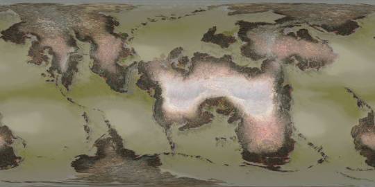
Here's what I've been up to lately! Three years after I created the original version, here's a revamp of the first planet I mapped out for @jayrockin's "Runaway to the Stars" project, the homeworld of their Centaur aliens. This post covers Phase One: Geology.


Firstly, the Equirectangular elevation maps with and without the color gradient layer, and tectonic plate map. This color gradient marks sea level, of course, and while there are inland areas that are *also* below that elevation, I have yet to determine which of those basins have lakes and seas therein, and how their shorelines compare; *that* will be seen once I figure out the climate : ) As for the Plate map, most of the smaller, oblong plates without any rift boundaries represent island chains or continent fragments that accreted onto larger landmasses; discretely marking those was helpful for placing and shaping the mountain ranges.


Next, the Poles-Centered Perspective maps, made possible with Photopea's Polar Coordinates tool. The planet's Southern hemisphere, centered on the south pole, is seen at left, and its Northern hemisphere is seen at right. Like the previous set of three, this set includes the color elevation map, greyscale elevation map, and solid color tectonic plates.


Last of all, the basis for the planet's current appearance: it's tectonic history! These gifs, in six frames, cover about 200 million years of continental drift, starting with the breakup of two Supercontinents, and was primarily achieved in Blender. This isn't my first time trying to reconstruct a tectonic history, but it *is* my first time doing so this quickly and efficiently, thanks to the process I developed here using this planet's continents as a test case.
There will be more phases in this project completed and shared in the coming months, thanks for checking out this one! Also, I've already shared these maps on Reddit, where you should be able to see them in even higher resolution. Photopea and Blender, 2025
#mapmaking#imaginary maps#photopea#blender#elevation maps#equirectangular projection#poles-centered perspective#rtts centaurs#fictional planets#runaway to the stars#worldbuilding#world map#imaginary plate tectonics#tectonic history sequence#physical geography#long term project#commissioned mapmaking#Christopher Maida Artwork
750 notes
·
View notes
Text


redraw of one of my old maps!
#illustration#dnd#dungeons and dragons#fantasy map#cartography#mapmaking#dnd art#city map#digital art#worldbuilding#maps
70 notes
·
View notes
Text
Sea creatures

Various medieval sea monsters that I draw on my fantasy maps
595 notes
·
View notes
Text
Commissioned Pokemon Fangame Map - The Jica Region of Pokemon Opal and Obsidian

Based off of Mexico with a set of islands in the northwest roughly analogous to Cuba filling it out, the main map is surrounded by a stone equivalent with pokemon rendered in a style based on Mayan writing characters.
Notable locations below include:
The Elite Four, the Chixculub Crater, the Resort Town, and Jica City
The two main story legendarys of Yveltal and Rayquaza are below.


list of all of the pokemon included on the map roughly from left to right/top to bottom is below:
Smeargle Variant, Regice, Regirock, Registeel, Scrafty, Wynaut, Wobbuffet, Heatmor, Durant, Litten, Torracat, Incineroar, Ditto, Mareep, Flaafy, Ampharos, Skrelp, Onix, Steelix, Roggenrola, Boldore, Ho-oh, Lugia, Wishiwashi, Anorith, Armaldo, Squirtle, Wartortle, Blastoise, Shellos, Hawlucha, Alcremie, Wooper Variant, Quagsire Variant, Chingling Variant, Chimecho Variant, Scatterbug, Spewpa, Vivillon, Klawf, Dedenne, Pichu, Pikachu, Raichu, Shedinja, Meloetta, Zeraora, Marshadow, Unown, Feebas, Milotic, Noibat, Noivern, Clobbopus, Grapploct, Snom, Frosmoth, Delibird, Cryogonal, Spearow, Fearow, Mega Rayquaza, Yveltal, Rayquaza, Minior, Arbok, Bulbasaur, Ivysaur, Venusaur, Feraligatr Variant, Druddigon, Uxie, Mesprit, Azelf
24 notes
·
View notes
Text


i shouldve posted this months ago i think but here is the monstrosity that is the kélas map, including linguistic and political maps. mostly in czech but i suppose you can figure out the main stuff, especially in the last map which is probably the most important one in regards to what im constantly yapping about. i might translate it one day
also featuring the phrase "map of the continent" in my conlangs:)
always subject to change btw. but that is normal with me. anyways im happy to answer any questions and i can clarify stuff if needed:]
#i hope tumblr wont destroy the quality because it is kind of vital here#my art#kélas#worldbuilding#fantasy worldbuilding#mapmaking#fantasy map#conlanging#conlangs#česky#č#anyways i still have to think about how i should put this onto the kélas site
43 notes
·
View notes
Text

Another ttrpg i recently tried is The Lonesome Cartographer, a solo mapmaking rpg by Wren-the-Forester on Itch.io (are they on tumblr? if so, i‘d love to find them!)
It is a fantastic game and i spent a lovely hour or so letting my mind wander with just a piece of paper, a pencil, a d6 and tarot cards. I made up the story and lore of the places as i went, with whatever came to mind. After, I scanned it and coloured it digitally.
I recommend it severely to anyone wanting to get back into the groove of spontaneous creating, especially if you‘ve been stressed and trapped in the systematics of daily life. This session and the map it resulted in inspired me to start making my own little ttrpg test system, Henoimos, which I am currently working on refining.
#junos artwork#art#new artist#artoftheday#small artist#comissions open#dnd art#dnd character#digital illustration#dnd commission#mapmaking#the lonesome cartographer#solo ttrpg#small ttrpg#ttrpg#indie ttrpg#ttrpg community#henoimos#ttrpg oc#doodlings
96 notes
·
View notes
Text
youtube
forgot to post the finish grandpa 2.0 cartoon on here!!
#calarts#grandpa 2.0#shin grandpa#zack and cody#pilot#animation#short film#short animation#animated pilot#bad#breaking bad#cartoon#go cartoons#90s#90s nostalgia#90s aesthetic#90s music#90s anime#90s style#90s tv shows#90s cartoons#mine#00s#00s nostalgia#00s aesthetic#00s anime#00s fashion#johnny test#dont watch it#art
128 notes
·
View notes
Text
How to Name Fantasy Places (Without Pulling Random Letters Out of a Hat)
Worldbuilding is all about making things feel real—and names carry the weight of your entire world’s history, culture, and mystery. So here’s a foolproof method for naming places that actually feel like places.
Step 1: Decide What This Place Means to the People Who Named It
Every name tells a story. Ask yourself:
What did the first people to settle or discover this place notice?
What is this location known for?
Is it sacred, cursed, rich, desolate?
Examples:
A towering forest could be called Whispergrove (for the sound of the leaves or the myths around it).
A desert ravine where travelers vanish might be The Hollow Path.
Step 2: Choose a Naming Style (Consistent with Your World)
Think about the culture that named it. Do they use:
Compound words (e.g. Stormwatch, Ravenfell)?
Descriptive + noun (e.g. Blackmoor, Silverdeep)?
Old tongue or language rules (e.g. Eldrinor, Vaskhara)?
Functional or mundane names (e.g. Southfield, The Western Reach)?
Stay consistent within a region or people group. Language = worldbuilding.
Step 3: Use This Naming Formula When You’re Stuck
If your brain’s fried and nothing sounds right, here’s a go-to naming formula that always gets the job done:
[Adjective or Descriptive Element] + [Geographic Term or Feature]
Try words like:
Descriptive: black, silent, shattered, ancient, golden, hollow, crimson
Features: hill, pass, reach, coast, vale, hold, watch, spine, hearth, barrow, fen
Examples:
Ashfen – a burnt wetland
Crimson Hold – a fortress with a bloodstained history
The Broken Reach – a territory that collapsed after war
Frosthollow – a snow-laden valley
You can also reverse it:
Glenmor (Glen = valley, Mor = great)
Ridgewyn – (Ridge = feature, wyn = an invented or repurposed word suggesting wind or joy)
Step 4: Don’t Be Afraid to Steal from Real Life (and Twist It)
Real world etymology is your friend:
Latin roots: Aurum Vale (Gold Valley)
Norse/Germanic: Drakenfjord (Dragon Fjord)
Old English: Thorneby (Settlement of Thorns)
Mash these with your own invented words or blend them with existing ones to sound just unfamiliar enough.
Step 5: Keep a Masterlist
Once you’ve named a few places, keep a naming glossary. This keeps your language consistent and helps with world cohesion.
Bonus: Don’t Try to Be Clever Every Time
Not every place needs to sound mystical. A town named Bridgemarket or Eastmere can be just as immersive. Let some names be simple. That’s what makes the epic ones stand out.
TL;DR
What does the place mean to the people who named it?
Pick a naming style that fits your world.
Use: [Descriptive] + [Feature] = instant immersion.
Pull from real etymology and adapt.
Keep it consistent—and don’t overcomplicate.
#writeblr#writing community#writers of tumblr#writing tips#fantasy writing#world building tips#world building#tumblr writers#mapmaking#fiction writing#rpg resources#writing resources#vivsinkpot
84 notes
·
View notes
Text
Map of the Solar System from Signalis

#signalis#maps#cartography#imaginary maps#mapmaking#worldbuilding#fallout#science fiction#scifi#scifiart#outer space#solar system#space
664 notes
·
View notes
Text
youtube
This video showcases my Blender model of the planet that the Scud aliens call home, the fourth and final world I've mapped out for @jayrockin's "Runaway to the Stars" project. A *lot* of maps were created in service of this final render, and also in service of presenting the special qualities of this planet. I intend to show you as many of these as I can under the cut, and also in subsequent posts focusing on some of the more interstitial, ancillary maps and figures that played a part in producing the primary maps you'll see in this main post.
Before I show the first maps I made for this project, what you see below are the satellite-style maps for the Equinoxes and Solstices, in order of (Northern) Spring, Summer, Fall, and Winter, the latter serving as the texture for the Blender object you saw in the video.


__________
With that matter covered, our next focus is this project's foundation: Geology. While I didn't spin as elaborate a tectonic history for this planet as I did for the Ayrum commission, I did work out as much detail as I could for the more recent geological activity, to set the stage for the elevation data - including a narrower focus on the coastal shallows that host the Scud populations.


__________
Once I could move on to climate, my first step was finding this planet's relative Insolation, which I managed thanks to @reversedumbrella's code and coaching. With an obliquity of only 16 degrees, this planet's yearly maximum Insolation levels stick close to the equator, compared to pole-to-pole oscillation we see on Earth

__________
Having a rough sense of where heat would concentrate seasonally and how the landmasses would deflect water in light of the planet's retrograde spin, I was able to set down the bi-annual ocean currents (Northern Summer above and Northern Winter below), then the monthly water temperatures pushed around by said currents, and finally -after factoring in many other considerations- the monthly land temperatures as well (combined in the second gif)


__________
Next came the seasonal air pressure maps and subsequent wind patterns (my first time creating those from scratch), which later factored into the precipitation maps. The incredible temperatures at the largest continent's interior make a desert of most of it, and the other interiors are fairly dry too, but all that heat on the equatorial ocean generates a *lot* of evaporation which ends up coming down elsewhere.


__________
With temperatures and precipitation mapped out for each month, I was able to find how the accumulation and melt of ice and snow played out, too. Given such a hot equator it's surprising to see freezing temperatures hold out in some places, but low obliquity and high elevation shield what areas they can, it seems.


__________
All this monthly data was then painstakingly combined and compared and plugged into equations to produce maps of discrete climate zones, using both the Köppen (left) and Trewartha (right) classification systems. The higher latitudes see some overlap with Earth's conditions, but the Tropics...


__________
I never really finished the map I wanted to make with my own loosely customized classification system, but I *did* get as far as this breakdown of the areas that sometimes surpass 56.7 degrees Celsius, Earth's record for highest surface temperature ever directly measured. And as you can see, that earthly record is broken by a *significant* fraction of this planet's surface, and far exceeded by the equatorial continent's deep interior

__________
The final phase of this project dealt with creating satellite maps of this planet's surface (which you saw at the top of this post), which started with a map of dry and submerged substrate, then a density map of the vegetation that sits atop it, then the colors of that vegetation under annual average conditions (demonstrating how they would appear in-person, rather than the area's appearance from orbit), and finally plant colors under seasonal conditions (same conceit as previous). In concert with the seasonal ice and snow maps, it was the four maps in the last sequence which were overlaid on the Substrate map, using the plant density map as raster masks, to produce the final Satellite-Style maps.


__________
This planet's sophonts being a marine species, it was then worth focusing on the conditions underwater, which included monthly seafloor temperatures (first gif), annual discharge of sediment from rivers (magenta in the 2nd gif), and seasonal upwelling of nutrients from deeper water (blue in the 2nd gif).


The creation of all my maps seen in this post was possible thanks to Photopea, which has been my go-to for several years now. The resolution kinda got crunched when I uploaded these here, so when I share them on Reddit later I'll add those links under this. These have also already been posted on Twitter, which you can see here if you like. Thanks for scrolling all the way down here!
#digital painting#Photopea#digital 3d#Blender#mapmaking#imaginary maps#Runaway to the Stars#Rtts Scuds#speculative planetology#speculative geology#speculative climatology#alien planet#major post#commission#christopher maida artwork#Youtube
783 notes
·
View notes
Text

shalhavar height map (WIP)
hello i never update this blog heehoo, here's a thing i've been working on for a big long while, i'm a big geography fan and this is just one of my many obsessive mapping endeavors
so as you can tell, this is still a WIP, but i'm very pleased with how it is looking so far, this map depicts the topography of Shalhavar, the country where most of my character cast (and lore) is based in
73 notes
·
View notes
Text
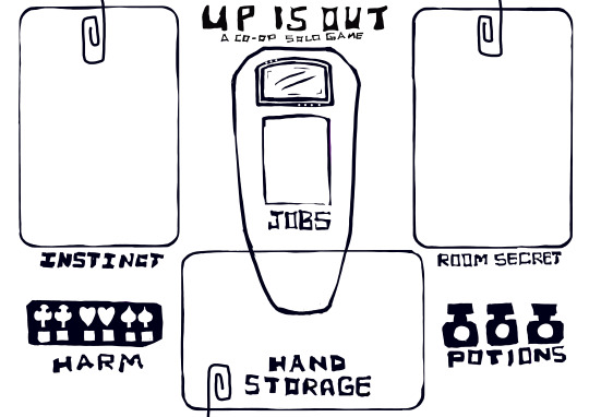
"Up is Out" is now in drivethrurpg !!
Up is Out is a co-op solo role playing game of exploration, resource management, map making, journaling, asymmetrical roles, and lore creation, that uses books you already own as sources to spark your imagination.
If anyone plays it, I'd love to hear your thoughts and know if you had fun with it :)
#ttrpg#roleplaying game#tabletop role playing game#indie ttrpg#solo ttrpg#co op games#worldbuilding#world building#used books#bibliophile#cards#card games#map making#mapmaking#exploración#ttrpg community#resource management#indie games#scifi#sci fi and fantasy#scifi ttrpg#original art
75 notes
·
View notes
Text
I’m currently cooped up and I have the weirdest request crossing my mind:
Cartography tumblr, I want to know about the most dogshit maps we have. These can be modern maps, or historical maps that would have been considered Bad by their contemporaries’ standards.
Barring that, I’m all for some weird map facts.
Help a guy out?
79 notes
·
View notes
Text
Dead God


Where do gods go when they die? A complex question with deep philosophical and theological implications, but in your setting of choice, perhaps one with a very simple answer. It could be a place, out of time and space, where decaying deific forms wither and rot, forgotten by all and no longer sustained by the power of belief. What manner of treasure, knowledge, or power might be found within such a long dead husk, and what bizarre and alien creatures might make their lair within one? That’s for you to decide, as you dazzle your players with these three maps, all animated, featuring an external and internal view of a massive humanoid carcass floating in a sea of stars. A giant, a god, or maybe just a regular-sized corpse visited by really tiny PCs?! A Fantastic Voyage into Innerspace awaits!
#dnd#battlemap#dungeonsanddragons#rpg#ttrpg#dungeonmaster#fantasymap#tabletoprpg#dndmaps#roll20#worldbuilding#pathfinder#cartography#fantasymaps#fantasy#rpgmap#tabletop#mapmaking#dndart#map#battlemaps#tabletopgames#inkarnate#dungeonsanddragonsart#dndmap#fantasyrpg#rpgmaps#foundryvtt#angelamaps
103 notes
·
View notes
Text

Backrooms Found Footage #3 Full Map (Kane Pixels Backrooms) Spent about 9 hours yesterday scouring the new found footage video by Kane Pixels to construct this full map just from the footage and by making best-guess inferences.
Some areas are easy-to-follow, while other areas are extremely difficult (usually due to the cutting of the camera and appearing somewhere completely different). But by using subtle inferences (such as the garage door areas, the elevator, etc), and backtracking several areas, an almost full drawn map can be made.
You can track the progress of our protagonist by following the black line at the beginning through his entire journey.
(AND of course if you haven't watched Mr. Kane Pixel's Backrooms video yet silly, I suggest you watch it!!! You can follow along the protagonists journey during the video if you like)
#art#artists on tumblr#digital art#mapmaking#the backrooms#liminal spaces#kane pixels#backrooms fanart#found footage#my art#liminal#back rooms#kanepixels
139 notes
·
View notes