#Satellite Technology
Explore tagged Tumblr posts
Visit Tumblr Blog
Explore Tumblr blogs with no restrictions, modern design and the best experience.
Last Seen Tumblr Blogs


Fun Fact
Tumblr has been banned in Indonesia for providing people with access to pornographic content.
Text
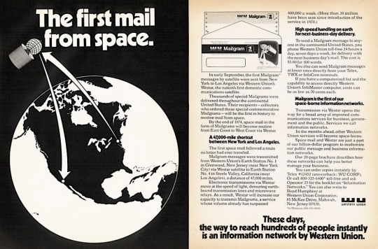
The first mail from space. Ad for Western Union’s Westar 1 satellite-based Mailgram service - 1974.
#vintage illustration#vintage advertising#western union#mailgrams#westar#satellites#satellite technology#satellite fleets#satellite communications#communications satellites#geosynchronous satellites#geosynchronous orbits#space#space technology#westar satellites#westar 1#hughes aircraft hs-333 satellite#hughes aircraft#electronics#vintage electronics#technology#vintage technology#communications#spaceflight#telegrams
5 notes
·
View notes
Text
Why India’s Presence in Space Matters for Its Growth and Development

When Indian-origin astronaut Shubhanshu Shukla lifted off as part of the Axiom-4 mission, it was more than just a personal milestone. It marked the return of an Indian presence in space after nearly forty years. The last time an Indian astronaut ventured beyond Earth’s atmosphere was in 1984 when Rakesh Sharma flew aboard a Soviet spacecraft. Since then, India has grown remarkably in space technology but stayed away from manned missions. Shukla's journey is a historic moment with long-term value for India’s scientific ambitions and global standing.
#India in space#Indian astronaut 2025#Shubhanshu Shukla Axiom-4#Gaganyaan mission#ISRO space program#India space growth#STEM education India#satellite technology#Indian space policy#space innovation#global influence space
0 notes
Text
Why space defence is no longer a pie in the sky for Indian companies
So, why is a company looking to sell satellite data to clients setting up an assembly line? Sharma says the decision was driven by the increasing interest over approximately the past six months from governments around the world to source their own space defence and surveillance infrastructure. Once a practically non-existent sector, space-based defence services, led by the demand for surveillance…
#companies#defence#Digantara satellite#galaxeye#GalaxEye surveillance data#geospatial defence#India space defence#India space manufacturing#Indian#Indian private space sector#Indian satellite startups#Indian space tech companies#indian startups#jsw defence#jsw defence and aerospace#JSW Defence Shield AI#longer#operation sindoor#Pie#private space startups india#satellite manufacturing#satellite surveillance India#satellite technology#sky#space#space situational awareness#startup#surveillance satellites#unmanned aerial systems India
0 notes
Text

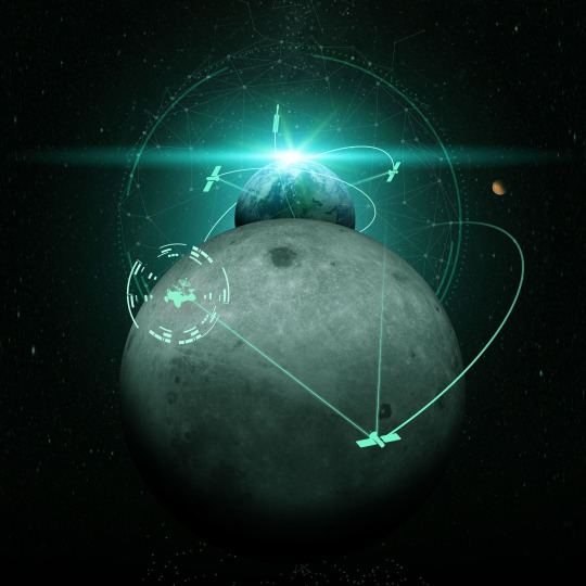
#Mars Planet#4K#satellites in orbit#NASA#navigation#communications concept#3D globes#GPS navigation#communication#Internet#satellite technology#satellites#satellite communications#planets#Mars#global communications#GPS#wallpapers
1 note
·
View note
Text
#AI Applications#Artificial Intelligence in Space#facts#Helium-3#Kessler Syndrome#life#Lunar Economy#Mars Exploration#Moon Mining#Orbital Debris#Podcast#Private Space Companies#Rare Earth Metals#Satellite Technology#serious#Space Ethics#Space Exploration#Space Innovations#Space Policy#Space Sustainability#Space Tourism#truth#upfront#website
0 notes
Text
The Critical Role of Greenhouse Gas Emissions Monitoring in Achieving Net-Zero Goals
Climate Now Debate: The Importance of Greenhouse Gas Emissions Monitoring This week’s Climate Now debate will explore the critical role of monitoring greenhouse gas (GHG) emissions and its significance in the global pursuit of achieving net-zero emissions. Our expert panellists will discuss the current technological challenges that hinder accurate and comprehensive measurements of certain sources…
#atmospheric monitoring#carbon dioxide#climate change#climate policy#Copernicus#emissions reporting#fugitive emissions#greenhouse gas emissions#methane#monitoring#net-zero emissions#nitrous oxide#satellite technology#technology
0 notes
Text
ISRO Set To Launch SSLV on Its Third Development Flight for Independence Day
The Indian Space Research Organisation (ISRO) plans to launch the Earth Observation Satellite-08 (EOS-08) using the Small Satellite Launch Vehicle (SSLV)-D3 on Independence Day, August 15, at 9:17 a.m.
Contents
Infrared ImagingOrbital Specs
The launch will occur from the Satish Dhawan Space Centre (SDSC) in Sriharikota, Andhra Pradesh. EOS-08 is intended to improve environmental monitoring, and disaster management, and assist with the Gaganyaan mission.
ISRO states, “It will complete the SSLV development project and support operational missions by Indian industry and NSIL.”
The satellite consists of three main payloads: the Electro-Optical Infrared Payload (EOIR), the Global Navigation Satellite System-Reflectometry payload (GNSS-R), and the SiC UV Dosimeter.
Infrared Imaging
The EOIR payload is designed to capture images in both the Mid-Wave Infrared (MIR) and Long-Wave Infrared (LWIR) bands, offering essential data for satellite-based surveillance, disaster monitoring, environmental observation, fire detection, tracking volcanic activity, and assessing industrial disasters.
To Read More Click Here...
#hot news#trending news blog#ISRO#Latest news#latest update#Mid-Wave Infrared#Orbital Specs#satellite technology#trending news#UV irradiance
0 notes
Text
Navigating the Seas: The Integration of Satellite Technology and Ship Trackers in Modern Maritime Navigation
Introduction:
Maritime navigation has undergone a significant transformation over the centuries, evolving from ancient methods reliant on celestial bodies to modern technologies driven by satellite systems. In today's globalized world, maritime transportation remains a cornerstone of international trade, with cargo ships serving as the primary vessels for transporting goods across oceans and seas. The integration of satellite technology and ship trackers has revolutionized maritime navigation, providing real-time monitoring, enhanced safety, and improved efficiency for cargo ships and other vessels. This article delves into the intricate relationship between maritime navigation, ship trackers, cargo ships, and satellite technology, exploring their roles and contributions in modern seafaring.

Maritime Navigation: A Historical Overview
Maritime navigation traces its roots back to ancient civilizations, where early mariners relied on natural landmarks, stars, and rudimentary instruments to navigate the open seas. Over time, advancements in navigation tools such as compasses, charts, and sextants facilitated more accurate positioning and course plotting. However, navigating vast expanses of water remained a daunting task, fraught with challenges such as unpredictable weather, treacherous shoals, and limited communication capabilities.
The Emergence of Ship Trackers
The dawn of the satellite era revolutionized maritime navigation, providing a means for ships to determine their precise location and track their movements in real-time. Ship tracking systems, initially developed for military and scientific purposes, soon found applications in commercial shipping. These systems utilize a network of satellites to transmit data on vessel positions, speeds, and trajectories, offering invaluable insights for shipowners, operators, and maritime authorities.
Cargo Ships: The Backbone of Global Trade
Cargo ships play a pivotal role in facilitating international trade, serving as the primary means of transporting goods between continents. From container ships carrying manufactured products to bulk carriers transporting raw materials, these vessels form the lifelines of global commerce. Ensuring the safe and efficient operation of cargo ships is paramount for shipowners and operators, driving the adoption of advanced navigation technologies such as ship trackers.
Satellite Technology: Powering Precision Navigation
Satellite technology lies at the heart of modern maritime navigation, providing a constellation of satellites that continuously orbit the Earth, transmitting signals that enable precise positioning and navigation. Global Navigation Satellite Systems (GNSS) such as GPS (Global Positioning System), GLONASS (Global Navigation Satellite System), and Galileo offer worldwide coverage and high accuracy, allowing ships to navigate complex routes with confidence. Additionally, satellite imagery and weather data provide vital information on ocean conditions, aiding mariners in route planning and hazard avoidance.
Enhancing Safety and Efficiency at Sea
Safety and efficiency are paramount concerns in maritime navigation, where the slightest error can have catastrophic consequences. Ship trackers equipped with Automatic Identification Systems (AIS) enable vessels to broadcast their identity, position, and course to nearby ships and shore-based authorities, facilitating collision avoidance and maritime traffic management. Furthermore, satellite-based tracking and monitoring capabilities enhance maritime security by enabling the surveillance of vessel movements in real-time, deterring illicit activities such as piracy and smuggling.
Future Perspectives and Challenges
Looking ahead, the integration of emerging technologies such as artificial intelligence (AI), machine learning, and big data analytics holds promise for further enhancing maritime navigation and cargo ship operations. Predictive analytics algorithms can anticipate vessel behavior, optimize route planning, and minimize fuel consumption, leading to cost savings and environmental benefits. However, challenges such as cybersecurity threats, regulatory compliance, and the need for skilled personnel pose significant hurdles in the widespread adoption of advanced navigation technologies.
Conclusion:
In conclusion, the integration of satellite technology and ship trackers has revolutionized maritime navigation, offering unprecedented levels of safety, efficiency, and security for cargo ships and other vessels. As technology continues to advance, stakeholders must embrace innovation while upholding the principles of seamanship to ensure the safe and sustainable movement of goods across the world's oceans. By leveraging the power of satellite technology and ship tracking systems, the maritime industry can navigate towards a future of enhanced connectivity, efficiency, and safety on the high seas.
0 notes
Text
Connectivity Redefined: Harnessing the Synergy of Mobile Satellite Services, Terrestrial Networks, Satellite Technology, and the Internet of Things
Introduction:
In an increasingly interconnected world, the convergence of Mobile Satellite Services (MSS), terrestrial networks, satellite technology, and the Internet of Things (IoT) is reshaping the way we perceive and experience connectivity. This fusion of technologies holds the promise of ubiquitous communication, enabling seamless data exchange and fostering innovation across diverse sectors. In this exploration, we delve into the synergies among these components and explore their collective impact on our digital ecosystem.
Mobile Satellite Services (MSS):
Mobile Satellite Services (MSS) have emerged as a lifeline for communication in remote and underserved regions, where traditional terrestrial networks struggle to provide coverage. By leveraging a constellation of orbiting satellites, MSS enables voice, data, and multimedia communication services to users, irrespective of their geographical location. This capability is invaluable during natural disasters, humanitarian crises, and maritime or aviation operations, where reliable communication is paramount for safety and coordination.
Moreover, MSS plays a pivotal role in extending connectivity to areas lacking adequate terrestrial infrastructure, such as rural communities and remote industrial sites. The evolution of MSS technology, including the deployment of high-throughput satellites and the integration of hybrid networks, further enhances its capacity and reliability, paving the way for innovative applications in sectors ranging from emergency response to global logistics.
Terrestrial Networks:
While MSS excels in providing coverage beyond terrestrial boundaries, terrestrial networks remain the backbone of everyday communication infrastructure. From fiber-optic cables to cellular towers, terrestrial networks facilitate high-speed data transmission and support a myriad of services, including voice calls, internet access, and multimedia streaming.
The advent of 5G technology represents a quantum leap in terrestrial networking, offering unparalleled bandwidth, ultra-low latency, and massive device connectivity. 5G's capabilities extend far beyond consumer communications, fueling advancements in augmented reality, autonomous vehicles, and smart cities. However, the deployment of 5G infrastructure poses challenges such as spectrum allocation, infrastructure deployment costs, and regulatory considerations.
The convergence of MSS with terrestrial networks presents a compelling solution to address these challenges and unlock new possibilities. Hybrid networks seamlessly integrate satellite and terrestrial communication, ensuring continuous connectivity across diverse environments. This convergence is particularly significant in bridging the digital divide, extending connectivity to remote areas, and enabling inclusive access to communication services worldwide.
Satellite Technology:
Satellite technology serves as the backbone of MSS, providing the infrastructure for global connectivity. Over the years, advancements in satellite design, propulsion systems, and launch technologies have transformed the capabilities and economics of satellite-based communication systems.
Traditional geostationary satellites offer wide coverage but suffer from latency issues due to their high-altitude orbits. In contrast, Low Earth Orbit (LEO) and Medium Earth Orbit (MEO) constellations have emerged as game-changers, offering lower latency and increased capacity.
Companies like SpaceX, OneWeb, and Amazon are spearheading the deployment of LEO mega-constellations, promising global broadband coverage with unprecedented speeds. These constellations not only cater to consumer internet needs but also unlock new opportunities for IoT applications, enabling seamless connectivity for billions of devices worldwide.
Internet of Things (IoT):
The Internet of Things (IoT) represents the interconnected network of devices, sensors, and systems, enabling data exchange and automation across various domains. IoT applications span diverse industries, from smart homes and cities to industrial automation and healthcare, driving efficiency, productivity, and innovation.
The integration of IoT with satellite and terrestrial networks amplifies the potential of connected devices, enabling real-time monitoring, data analytics, and remote control functionalities. In agriculture, IoT sensors combined with satellite imagery optimize crop management practices, minimize resource wastage, and maximize yields.

In smart cities, IoT-enabled infrastructure enhances urban services, improves resource allocation, and enhances quality of life for residents. Furthermore, in healthcare, IoT devices enable remote patient monitoring, telemedicine consultations, and personalized treatment plans, extending healthcare access and improving patient outcomes.
The convergence of Mobile Satellite Services (MSS), terrestrial networks, satellite technology, and the Internet of Things (IoT) represents a paradigm shift in connectivity, empowering individuals, businesses, and communities worldwide. By harnessing the synergies among these technologies, we can overcome geographical barriers, bridge the digital divide, and unlock new frontiers of innovation and prosperity. As we navigate the complexities of an increasingly connected world, collaboration, innovation, and inclusivity will remain critical in shaping a future where connectivity knows no bounds.
0 notes
Text
Navigating Connectivity: The Definitive Guide to Satellite Phones in India

In a world that's rapidly advancing in terms of technology, connectivity remains paramount, especially in regions where traditional means of communication might be unreliable or inaccessible. Satellite phones emerge as a beacon of hope in such scenarios, offering seamless communication regardless of geographical barriers. For a country as vast and diverse as India, where connectivity can still be a challenge in remote areas, satellite phones represent more than just a luxury; they're a necessity.
Understanding Satellite Phones
Before delving into the specifics of acquiring a satellite phone in India, it's crucial to grasp the fundamentals. Unlike conventional mobile phones that rely on terrestrial cell towers, satellite phones connect directly to satellites orbiting the Earth. This allows them to function in areas where traditional networks don't reach, such as deserts, oceans, or mountains.
Satellite Phone Landscape in India
India, with its expansive terrain encompassing bustling cities and remote villages, presents a unique landscape for telecommunications. While major urban centers enjoy robust cellular networks, many rural and remote areas struggle with connectivity issues. This is where satellite phones step in, bridging the gap and ensuring communication continuity.
Satellite Phone Options and Prices
One of the primary considerations when purchasing a satellite phone in India is the cost. Satellite phones typically come with a higher price tag compared to conventional mobile devices, primarily due to the advanced technology involved. However, the investment is justified by the unparalleled coverage they offer, making them indispensable for certain professions and situations.
In India, the state-owned telecommunications provider, Bharat Sanchar Nigam Limited (BSNL), offers satellite phones catering to various needs and budgets. The BSNL satellite phone prices vary depending on the model and features, but they are generally competitive considering the services provided.
BSNL Satellite Phone India Price
For those looking to invest in a satellite phone in India, BSNL is a reliable option. The BSNL satellite phone price in India varies based on factors such as model, features, and subscription plans. While specific pricing details may fluctuate, BSNL typically offers packages tailored to different user requirements, whether it's for personal use, corporate needs, or emergency situations.
How to Buy a Satellite Phone in India
Purchasing a satellite phone in India involves a few essential steps to ensure a smooth and seamless experience:
Research: Begin by researching different satellite phone models available in the Indian market, considering factors such as coverage, durability, and battery life.
Select a Provider: Choose a reputable provider like BSNL that offers reliable satellite phone services in India. Evaluate their coverage area, network reliability, and customer support.
Choose a Plan: Depending on your usage requirements, select a suitable subscription plan offered by the provider. Plans may vary in terms of minutes, data, and geographical coverage.

Purchase the Phone: Once you've chosen a provider and plan, proceed to purchase the satellite phone. This can typically be done online through the provider's website or through authorized retailers.
Activate and Test: Upon receiving the satellite phone, follow the activation instructions provided by the provider. Test the device in different locations to ensure connectivity and functionality.
Conclusion
Satellite phones have revolutionized communication, especially in regions with limited infrastructure or during emergencies where traditional networks may fail. In India, the availability of satellite phones, coupled with initiatives by providers like BSNL, ensures that individuals and organizations can stay connected even in the most remote areas. By understanding the landscape, options, and purchasing process, acquiring a satellite phone in India becomes a straightforward endeavor, empowering users with reliable communication capabilities wherever they may be.
#satellite phone#satellite phone india#satellite phone price#satellite technology#satellite phones price in india
1 note
·
View note
Text

#Planet Earth#4K#satellites in orbit#navigation#communications concept#3D globes#GPS navigation#communication#Internet#satellite technology#satellites#satellite communications#planets#Earth#global communications#GPS#wallpapers
0 notes
Text
0 notes
Text
#Tags:AI-Driven Analysis#Data Collection#Data Monetization#Elon Musk#facts#Global Connectivity#Global Surveillance#Internet Privacy#IoT Integration#life#Metadata#Podcast#Privacy Concerns#Satellite Internet#Satellite Technology#serious#Social Media Platforms#Space Missions#SpaceX#Starlink#straight forward#Telemetry Data#truth#upfront#website#X (formerly Twitter)
0 notes
Text
Global Village

We shape our buildings; thereafter they shape us. Winston Churchill, 1943
A symbiosis between NASA and the shrinking of the world into a global village informs the provenance of the telecommunications industry. The export of satellite technology from the pages of science fiction into the ether above was first articulated by the polymath Arthur Clark in 1945. Seminal to the industry the white-paper titled ‘Extra-Terrestrial Relays’ conjured up a world not connected by short-wave radio or a lattice of undersea cables but rather by signals bounced off stations in the void of space. A web of these satellites orbiting the earth unfettered by atmospheric disturbances could be a medium for real-time communication. The sheer audacity of this idea cannot be stressed enough. When the monograph was penned humanity had scarcely pierced the boundaries of space with its primitive technology. The highest altitude recorded by a V-2 rocket topped the distance of 189km in suborbital flight (Lee 2020). Just for Clarke’s hypothetical satellite to be entertained it would need to reach the threshold of 36,000km. The grandiosity of this foresight evokes the same futurism gleaned from Leonardo da Vinci’s first doodles on the mechanics of flight centuries ahead of their invention. But rather than be dismissed as a fit of daydreaming in less than two decades were these wild speculations of satellite technology brought to life.
America’s formal dalliance with transmitting signals into the vast unknown began with President Eisenhower’s industrial policy in 1958. Abreast of Projects Mercury, Gemini and Apollo another triptych begot a quantum leap in the separate firmament of global communication during the jet age. Projects Echo, Relay and Syncom each escalating in sophistication came to experiment with bouncing microwave frequencies off passive and active satellites from ground stations below. A diverse consortium of firms brainstormed these instruments under the auspices of NASA. In the halcyon days of adventurism into the cosmos Project Echo became a totem for a proof of concept to test whether radio signals could piggyback on objects in orbit for the sake of long-distance communication. This maiden satellite from 1960 was effectively a monolithic balloon of aluminized Mylar whose reflective properties redirected signals from a laboratory in California to one in New Jersey. Initially the Aeronautics Division of the foodstuff maker General Mills was recruited to build this galactic mirror but when it was discovered that it would fray in the inhospitable vacuum of space the firm was jettisoned for the Schjeldahl company. To stave off premature ruptures of the orb’s skin a single fortified seam was introduced versus the previous patchwork.

Upping the ante in technical specifications for the sequel to Project Echo was the Relay satellite which sought to undo the tyranny of geography. Communication signals via traditional infrastructure were liable to degradation over long distances at a prohibitive cost in capital. By contrast the bandwidth of Project Relay exhibited a fidelity heretofore unseen with the bonus of transmitting across further expanses. Whereas short-wave radio failed to penetrate the vicissitudes of atmospheric conditions whether it be through fog or rain this alternative had no such deficit that may throttle it. Moreover skeptics had to be reminded about the economies of scope whereby television, radio and telephone signals could be diffused on a single piece of hardware rather than across a multitude of terrestrial stations like in legacy systems. No longer would the geometry of communication be at the mercy of oceans or mountains but instead find deliverance in the airwaves far above. Thus the utility of Project Relay was not lost on policymakers whose analysis of the costs and benefits vindicated the industrial policy to finance it. Project Relay legitimized satellites when operational expenditures were bound to plummet as the onus of maintenance was removed. Telecommunications therefore was the very first technology to commercialize space.

A jigsaw of private stakeholders pooled resources together to inaugurate this next chapter in the study of satellite technology. One particular enigma that needed to be demystified promptly was the longevity of Relay’s testbed as its honeycomb of solar cells would face a barrage of cosmic radiation in the Van Allen Belt. The rate of degradation had to be probed and then mitigated if delicate electronics were to weather the wilds of space. Any viability hinged on ensuring a lengthy lifecycle of the satellite in this minefield of hazards and so advanced measuring hardware approximated 11 percent of the weight for the first iteration (Ezell 1988: 376). The omnipresence of radiation had to be properly understood lest the enterprise become a financial sinkhole. Relay 1 in turn would be the proverbial canary in the coal mine to measure the inimical effects of these energy particles as each critical system was made redundant with a backup in the event of a malfunction. After the first launch in 1962 the second satellite in 1964 boasted upgrades with shielding far more resilient to radiation than the preceding prototype. Relay 2 learned from its sibling and later broadcast segments of the Winter Olympic Games in Austria a few days upon the start of its mission. The program was the first to master real-time communication.
In the saga of Cold War politics America paraded its soft power with the apotheosis of Syncom that followed in the footsteps of the foregoing Relay program. Although less romanticized in the public imagination than the lunar missions but of equal salience this final prototype sought a geostationary orbit above the equator relative to a fixed point on the ground. Such a static position aloft in space relayed signals for one-third of Earth in a revolution for telecommunications. This portmanteau of ‘synchronous communication’ epitomized a giant leap in technology. At an altitude of 35,768km the parity of speed between Syncom and Earth’s rotation intimated the satellite could synchronize with one location on the terrestrial surface and hover above it. In this precise position the system and its solar cells would be continuously recharged by the sun. Whilst minor propulsion difficulties hobbled Syncom 2 with its figure-eight pattern above the sky after its predecessor completely floundered the third iteration nudged itself into the coveted spot of a geostationary orbit. Instant communication was made a reality as Syncom became globalization’s progenitor where citizens were no longer spectators but rather participants to world events. NASA thus created an information super highway for the world.

In the pyrotechnics to explore and exploit the final frontier the connectivity that ensued from transmitting voice, data and video via microwaves irrevocably changed the world economy. Analogous to President Theodore Roosevelt’s industrial policy of building the Panama Canal in 1904 meant to truncate the journey around South America’s Cape Horn did NASA’s satellites induce a similar vector of growth. Government funding coupled with public-private alliances integrated markets akin to how faster transit by ship aroused the same effect although the latter clearly manifested in more analogue ways. The Information Age cultivated by satellite technology came to midwife a multi-billion dollar industry whose downstream effects hastened economic globalization. Traders on Wall Street could navigate London and Tokyo stock exchanges devoid of any lag in financials. Multinationals began to exercise greater agency in managing supply chains. Media transcended borders to diffuse a monoculture of capitalism amidst the spectre of sabre-rattling from Cold War hostilities. A digital Silk Road thereby homogenized markets as transaction times were whittled down from days to seconds. Commerce then seized upon the alacrity at which capital moved since geographical determinism was no longer germane to growth.
0 notes
Text
NavIC: India's Indigenous Navigation Satellite System
In the realm of space technology, India has made significant strides over the years. One such achievement is the Navigation with the Indian Constellation, commonly known as NavIC. Developed and launched by the Indian Space Research Organisation (ISRO), NavIC is India’s very own regional satellite navigation system. This article delves into the intricacies of NavIC, exploring its inception,…

View On WordPress
0 notes
Text
All-Star Moments in Space Communications and Navigation
How do we get information from missions exploring the cosmos back to humans on Earth? Our space communications and navigation networks – the Near Space Network and the Deep Space Network – bring back science and exploration data daily.
Here are a few of our favorite moments from 2024.

1. Hip-Hop to Deep Space
The stars above and on Earth aligned as lyrics from the song “The Rain (Supa Dupa Fly)” by hip-hop artist Missy Elliott were beamed to Venus via NASA’s Deep Space Network. Using a 34-meter (112-foot) wide Deep Space Station 13 (DSS-13) radio dish antenna, located at the network’s Goldstone Deep Space Communications Complex in California, the song was sent at 10:05 a.m. PDT on Friday, July 12 and traveled about 158 million miles from Earth to Venus — the artist’s favorite planet. Coincidentally, the DSS-13 that sent the transmission is also nicknamed Venus!

NASA's PACE mission transmitting data to Earth through NASA's Near Space Network.
2. Lemme Upgrade You
Our Near Space Network, which supports communications for space-based missions within 1.2 million miles of Earth, is constantly enhancing its capabilities to support science and exploration missions. Last year, the network implemented DTN (Delay/Disruption Tolerant Networking), which provides robust protection of data traveling from extreme distances. NASA’s PACE (Plankton, Aerosol, Cloud, ocean Ecosystem) mission is the first operational science mission to leverage the network’s DTN capabilities. Since PACE’s launch, over 17 million bundles of data have been transmitted by the satellite and received by the network’s ground station.
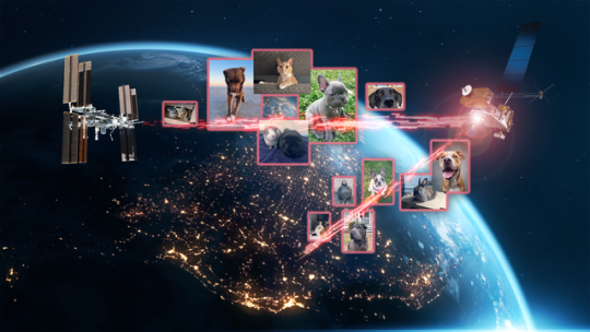
A collage of the pet photos sent over laser links from Earth to LCRD and finally to ILLUMA-T (Integrated LCRD Low Earth Orbit User Modem and Amplifier Terminal) on the International Space Station. Animals submitted include cats, dogs, birds, chickens, cows, snakes, and pigs.
3. Who Doesn’t Love Pets?
Last year, we transmitted hundreds of pet photos and videos to the International Space Station, showcasing how laser communications can send more data at once than traditional methods. Imagery of cherished pets gathered from NASA astronauts and agency employees flowed from the mission ops center to the optical ground stations and then to the in-space Laser Communications Relay Demonstration (LCRD), which relayed the signal to a payload on the space station. This activity demonstrated how laser communications and high-rate DTN can benefit human spaceflight missions.

4K video footage was routed from the PC-12 aircraft to an optical ground station in Cleveland. From there, it was sent over an Earth-based network to NASA’s White Sands Test Facility in Las Cruces, New Mexico. The signals were then sent to NASA’s Laser Communications Relay Demonstration spacecraft and relayed to the ILLUMA-T payload on the International Space Station.
4. Now Streaming
A team of engineers transmitted 4K video footage from an aircraft to the International Space Station and back using laser communication signals. Historically, we have relied on radio waves to send information to and from space. Laser communications use infrared light to transmit 10 to 100 times more data than radio frequency systems. The flight tests were part of an agency initiative to stream high-bandwidth video and other data from deep space, enabling future human missions beyond low-Earth orbit.
The Near Space Network provides missions within 1.2 million miles of Earth with communications and navigation services.
5. New Year, New Relationships
At the very end of 2024, the Near Space Network announced multiple contract awards to enhance the network’s services portfolio. The network, which uses a blend of government and commercial assets to get data to and from spacecraft, will be able to support more missions observing our Earth and exploring the cosmos. These commercial assets, alongside the existing network, will also play a critical role in our Artemis campaign, which calls for long-term exploration of the Moon.
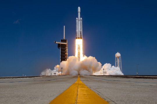
On Monday, Oct. 14, 2024, at 12:06 p.m. EDT, a SpaceX Falcon Heavy rocket carrying NASA’s Europa Clipper spacecraft lifts off from Launch Complex 39A at NASA’s Kennedy Space Center in Florida.
6. 3, 2, 1, Blast Off!
Together, the Near Space Network and the Deep Space Network supported the launch of Europa Clipper. The Near Space Network provided communications and navigation services to SpaceX’s Falcon Heavy rocket, which launched this Jupiter-bound mission into space! After vehicle separation, the Deep Space Network acquired Europa Clipper’s signal and began full mission support. This is another example of how these networks work together seamlessly to ensure critical mission success.
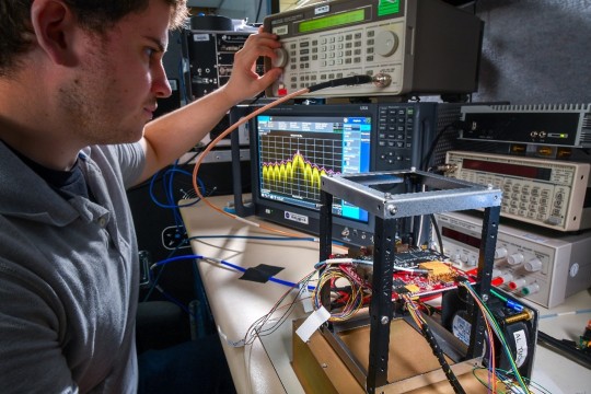
Engineer Adam Gannon works on the development of Cognitive Engine-1 in the Cognitive Communications Lab at NASA’s Glenn Research Center.
7. Make Way for Next-Gen Tech
Our Technology Education Satellite program organizes collaborative missions that pair university students with researchers to evaluate how new technologies work on small satellites, also known as CubeSats. In 2024, cognitive communications technology, designed to enable autonomous space communications systems, was successfully tested in space on the Technology Educational Satellite 11 mission. Autonomous systems use technology reactive to their environment to implement updates during a spaceflight mission without needing human interaction post-launch.
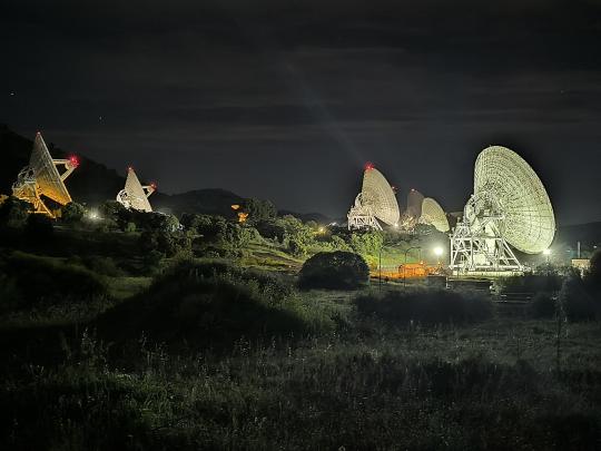
A first: All six radio frequency antennas at the Madrid Deep Space Communication Complex, part of NASA’s Deep Space Network (DSN), carried out a test to receive data from the agency’s Voyager 1 spacecraft at the same time.
8. Six Are Better Than One
On April 20, 2024, all six radio frequency antennas at the Madrid Deep Space Communication Complex, part of our Deep Space Network, carried out a test to receive data from the agency’s Voyager 1 spacecraft at the same time. Combining the antennas’ receiving power, or arraying, lets the network collect the very faint signals from faraway spacecraft.
Here’s to another year connecting Earth and space.
Make sure to follow us on Tumblr for your regular dose of space!
1K notes
·
View notes