#Satellite Tracking
Explore tagged Tumblr posts
Visit Tumblr Blog
Explore Tumblr blogs with no restrictions, modern design and the best experience.
Last Seen Tumblr Blogs


Fun Fact
The “We are the 99%” Tumblr blog became the slogan for the Occupy Wall Street movement.
Text

Gillian Anderson and Kristin Lehman in The X-Files (1993) Kill Switch
S5E11
Mulder and Scully's investigation into a mass shooting in a coffee shop leads them to believe that the targets were not the low level drug dealers and wholesalers who were killed but rather Donald Geldman who had been sitting at a table working on his laptop computer. The Lone Gunmen tell Mulder and Scully that Geldman was one of the original computer geniuses who disappeared years before. His laptop leads the agents to a hacker, Esther Nairn, who goes by the name Invisigoth. She tells them of a vast government conspiracy involving artificial intelligence that allows them to see everything and take action against all enemies.
*Gillian Anderson's fight scene with the nurses is one of the actress' favorite scenes in the series.
#The X-Files#tv series#1993#1998 episode#Kill Switch#S5E11#Gillian Anderson#Kristin Lehman#hacker#artificial intelligence#conspiracy#thriller#scifi#FBI investigation#Fox Mulder#Dana Scully#satellite tracking#electrocution#explosions#virtual reality headset#internet#the lone gunman#conspiracy thriller#drama#adventure#crime#mystery#just watched#Invisigoth
16 notes
·
View notes
Text
Satellites: Their Orbits, Tracking Systems, and Essential Uses
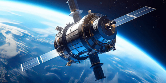
Satellites: Their Positions, Tracking, and Importance
Satellites have become an essential part of modern life, orbiting Earth and providing us with services ranging from communication and navigation to weather forecasting and space exploration. As of 2024, thousands of active satellites are circling our planet, each performing a specific role to enhance the quality of life on Earth. This article delves into the positioning of satellites, how they are tracked, what they track, and the significance of their roles.
Types of Satellite Orbits and Their Positions
Satellites are positioned in various orbits depending on their intended functions. These orbits determine how close the satellite is to Earth, how fast it moves, and what areas it covers.
Low Earth Orbit (LEO): Altitude: 180 km to 2,000 km Satellites in LEO include most Earth observation satellites, the International Space Station (ISS), and some communication satellites. These satellites are closer to the Earth, enabling them to capture high-resolution images. Functions: Used for imaging, remote sensing, and some communication purposes. Examples: ISS, Earth observation satellites like Landsat.
Medium Earth Orbit (MEO): Altitude: 2,000 km to 35,786 km Satellites in MEO are mainly used for navigation. This orbit offers a good balance between coverage and latency. Functions: GPS satellites and other global navigation systems. Examples: GPS, GLONASS, and Galileo satellites.
Geostationary Orbit (GEO): Altitude: 35,786 km above the equator Satellites in GEO move at the same rotational speed as Earth, meaning they stay fixed over one location on Earth. These are mostly communication and weather satellites. Functions: Used for television broadcasts, weather monitoring, and some types of communication. Examples: Weather satellites (GOES series), telecommunication satellites.
Highly Elliptical Orbit (HEO): Orbit shape: An elongated orbit with one point closer to Earth (perigee) and another point much farther away (apogee). Functions: Ideal for regions at high latitudes, providing prolonged coverage over areas like Russia and parts of Canada. Examples: Molniya satellites for communication in Russia.
How Satellites Are Tracked
The sheer number of satellites in space, combined with space debris, means tracking them is essential to avoid collisions and ensure their functionality. Ground stations and dedicated space agencies continuously monitor satellites. Several methods are used to track satellites:
Radar and Ground-Based Systems: Ground stations use radar to track satellites in LEO. These systems bounce radio waves off the satellite and measure the time it takes for the signal to return. By doing this repeatedly, they can track a satellite's location and speed.
Global Positioning System (GPS): Satellites in higher orbits like MEO or GEO are tracked using onboard GPS receivers. GPS helps calculate the satellite’s position and relay that data back to Earth.
Optical Tracking: Telescopes and cameras are used to visually observe satellites in higher orbits. This method is particularly useful for tracking objects that do not emit radio signals or need to be monitored for their physical characteristics.
Space Surveillance Networks: Agencies such as the U.S. Space Surveillance Network (SSN) and similar organizations in other countries continuously monitor satellites and space debris. They catalog objects and issue alerts for potential collisions.
What Satellites Track
Satellites are equipped with various sensors, cameras, and instruments to track a wide array of data on Earth, in space, and beyond:
Weather and Climate Data: Satellites such as NOAA’s GOES series monitor weather patterns, hurricanes, and long-term climate changes. They provide crucial data for meteorological services.
Earth Observation: Satellites like Landsat capture high-resolution images of Earth's surface. These images are used for mapping, agricultural planning, disaster response, and environmental monitoring.
Navigation Signals: GPS and other GNSS (Global Navigation Satellite Systems) satellites send signals that are used for navigation by smartphones, vehicles, ships, and airplanes worldwide.
Communication: Satellites facilitate global communication by relaying TV, radio, and internet signals across vast distances.
Space Exploration: Space telescopes like the Hubble Space Telescope track distant galaxies, nebulae, and black holes, helping scientists study the universe.
Military Surveillance: Many satellites are designed for defense purposes, tracking missile launches, military movements, or spying on potential threats.
Number of Satellites in Space
As of 2024, there are approximately 8,000 operational satellites orbiting Earth. The exact number fluctuates as new satellites are launched and old ones are decommissioned. Additionally, space agencies and private companies like SpaceX continue to launch large satellite constellations, such as Starlink, which alone has over 5,000 satellites in orbit for global internet coverage.
The Usefulness of Satellites
Satellites have become indispensable in modern life, serving a wide variety of purposes that impact everyday activities and critical global functions:
Key Functions of Satellites:
Communication: Satellites enable long-distance communication by transmitting data, television, and internet services. Without them, global broadcasting and real-time communication in remote areas would be impossible.
Navigation: Systems like GPS help millions of people navigate in real-time. They are also vital for the functioning of aviation, maritime travel, and even agricultural practices.
Earth Observation: Satellites provide high-resolution imagery of Earth, helping with disaster management, urban planning, agriculture, and environmental monitoring. For instance, they can track deforestation or observe glaciers' melting rates.
Weather Forecasting: Weather satellites provide the data needed for accurate predictions, storm tracking, and climate monitoring. This information is critical for preparing for natural disasters like hurricanes or floods.
Scientific Research and Exploration: Space telescopes and interplanetary satellites gather data on space phenomena, expanding our understanding of the universe. Satellites also conduct scientific experiments in the microgravity of space.
Defense and Security: Satellites are used for military surveillance, early-warning systems, and missile detection, playing a crucial role in national security.
Satellite Highlights in Brief:
Types of orbits: LEO, MEO, GEO, HEO, each serving different purposes.
Tracking methods: Radar, GPS, optical tracking, and space surveillance networks.
Data tracked by satellites: Weather, Earth observation, navigation signals, space exploration, and military surveillance.
Number of active satellites: Approximately 8,000.
Key roles: Communication, navigation, weather forecasting, Earth observation, scientific research, and defense.
In conclusion, satellites are essential tools for global communication, navigation, monitoring Earth's environment, and scientific discovery. As technology advances and the number of satellites continues to grow, their impact on our daily lives will only increase. Whether improving how we predict the weather, navigate through traffic, or explore the universe, satellites will continue to be a critical resource for humanity.
Go To How Satellites Work and What They Track
#satellite orbits#satellite tracking#satellite functions#low earth orbit#geostationary orbit#medium earth orbit#space technology#GPS satellites#communication satellites#weather satellites#Earth observation#satellite uses#satellite positions#how satellites work#space surveillance#satellite navigation#satellite networks#satellite importance#global navigation systems
7 notes
·
View notes
Text
youtube

Biologist Martin Wikelski tags a scarlet macaw with an ICARUS transmitter. COURTESY OF MARTIN WIKELSKI
Excerpt from this story from Yale E360:
Field biologists tend to be a patient lot, often resigned to long days and weeks in the field and committed to experiments that take years to yield results. But even among that dogged crowd, Martin Wikelski stands out.
Back in 2001, sitting on a porch one evening in Panama, the German ornithologist had the germ of an idea for an “internet of animals,” a global system of sensor-wearing wildlife that would reveal the planet’s elusive, nonhuman worlds. He figured he could get it up and running by 2005. Nearly 20 years later, Wikelski may have finally succeeded — after surmounting roadblocks that range from bureaucratic mishaps to technical glitches to a geopolitical crisis. His space-based system, known as ICARUS (International Cooperation for Animal Research Using Space), is now scheduled to launch, in its latest, satellite-based incarnation, on a private rocket sometime in 2025.
The underlying idea of the internet of animals is to tune into the planet’s hidden phenomena — the flight paths followed by sharp-shinned hawks, the precise fates befalling Arctic terns that die young, the exact landscape requirements of critically endangered saiga antelope — by attaching tiny, solar-powered tracking devices, some weighing less than a paperclip, to all kinds of organisms and even some inanimate objects (glaciers, ocean plastic debris). The inexpensive, globe-spanning system of animal tagging is meant to help scientists understand the precise drivers of global change, and much more, by tracking thousands of tagged animals from space and tying their experiences to the broader impacts facing whole populations or even species.
Wikelski, the director of the Department of Migration at the Max Planck Institute of Animal Behavior, in Germany, said the prospect of having that data, and of “making people aware of the incredible beauty and richness of what’s happening out there,” has made the effort worthwhile, even urgent. It’s also true, as he wrote in his recent book The Internet of Animals: Discovering the Collective Intelligence of Life on Earth, that he “had no clue how many pitfalls there would be… how many times when we desperately wanted to give up, because the whole process had become so exquisitely frustrating that we just couldn’t stand it anymore.”
In 2018, after years of working with designers, engineers, and government officials from multiple countries and continents, Wikelski’s team saw its ICARUS receiver launch aboard a Soyuz rocket from Kazakhstan to the International Space Station, where Russian cosmonauts attached it to their side of the orbiting lab. “We danced, cried, and hugged one another,” Wikelski wrote of the launch. “All the stress of nearly 20 years fell away.”
3 notes
·
View notes
Text
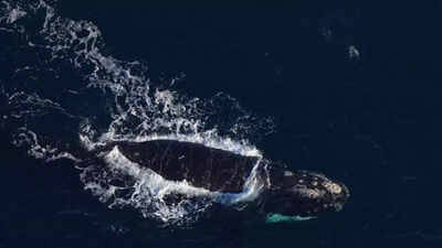
NASA satellites track plankton swarms from space to protect North Atlantic right whales | - The Times of India
The North Atlantic Right Whale (NARW), one of the most critically endangered mammals on Earth, continues to be threatened with several dangers despite the prohibition of commercial whaling. Entanglement in fishing nets and collisions with ships are now the greatest dangers to their existence. To help protect these whales from these dangers, scientists have come up with creative ways of monitoring…
View On WordPress
#NASA#NASA satellite#North Atlantic Right Whale#plankton tracking#protect right whales#right whale protection#satellite tracking
1 note
·
View note
Text
गुगलबाबा प्रवासात मार्गदर्शन
जगातील १२२ देशांमध्ये गुगलचे नेव्हिगेशन ॲप वापरण्यात येते. ॲपलचे वाझे हे स्वतंत्र ॲप्लिकेशन असले तरी ॲपलचे फोन सर्वानाच घेणे शक्य होत नाही. बहुतांश लोकांकडे अँड्रॅईड यंत्रणा असणारे विविध कंपनीचे मोबाईल फोन आहेत. त्यामुळे जगातील काही अपवाद वगळता सर्वत्र गुगलबाबा प्रवासात मार्गदर्शन करत असते. डॉ. व्ही. एन. शिंदे,शिवाजी विद्यापीठ, कोल्हापूर मार्गदर्शक गुगलबाबा ! पर्यटन, प्रवास लोकांची सवयीचा झाला…
#Google Maps#GPS navigation#India GPS#location services#NAVIC system#satellite tracking#travel guide#V N Shinde#उपग्रह ट्रॅकिंग#गुगल मॅप#जीपीएस नेव्हिगेशन#नाविक प्रणाली#प्रवास मार्गदर्शक#भारत जीपीएस#व्ही एन शिंदे#स्थान सेवा
0 notes
Text
Kpler Acquisition of Spire Maritime: A New Era in Maritime Data
Kpler Acquisition of Spire Maritime
Kpler Acquisition of Spire Maritime: A New Era in Maritime Data
The recent acquisition of Spire Maritime by Kpler marks a transformative moment in the maritime data and analytics sector, promising an overhaul in how maritime operations are managed and analyzed. Kpler, a leader in transparency solutions for commodity markets, continues its strategic expansion with this acquisition. Previously, Kpler acquired MarineTraffic and FleetMon in 2023, and now Spire Maritime, renowned for AIS data and satellite tracking services, joins its portfolio.
The Kpler acquisition, valued at approximately $241 million, is expected to close by the first quarter of 2025. This strategic move aims to integrate Spire Maritime’s advanced technologies with Kpler’s terrestrial AIS network, enhancing real-time visibility and analytics across maritime and commodity markets.
This acquisition is set to revolutionize the maritime industry by improving decision-making, risk management, and operational efficiency through enhanced data accuracy. Kpler plans to leverage these capabilities to drive innovation, potentially setting new industry standards. Furthermore, increased transparency may lead to stricter regulatory compliance, while stimulating competition as other firms strive to keep pace.
In conclusion, the Kpler acquisition of Spire Maritime is poised to usher in a new era of maritime data analytics, offering extensive benefits such as improved shipping routes, vessel tracking, and environmental protection. This pivotal move not only strengthens Kpler's market position but also heralds significant advancements in maritime operations and transparency.
Kpler acquisition
0 notes
Text
Stay on Track Anywhere and Explore the Best in Satellite and GPS Trackers

In the dynamic landscape of modern connectivity, Orbital Satcom presents an array of cutting-edge trackers designed to keep you in control no matter where life takes you. Our extensive range includes satellite trackers, personal satellite trackers, GSM trackers, and GPS handhelds, ensuring that you have the perfect solution for your tracking needs. Orbital Satcom's trackers are more than just devices; they are reliable companions for adventurers, professionals, and anyone who values precision and security. Our satellite trackers leverage advanced satellite technology, providing real-time location data even in the most remote areas where traditional GPS signals may falter.
Whether you're exploring off the beaten path, managing a fleet, or ensuring the safety of loved ones, our trackers offer unparalleled accuracy and functionality. From personal satellite trackers for individual use to GSM trackers for everyday applications, Orbital Satcom delivers quality solutions that redefine tracking possibilities. Explore the freedom of staying connected and informed with Orbital Satcom's diverse range of trackers. With our commitment to innovation and reliability, you can trust Orbital Satcom to provide you with the best in satellite and GPS tracking technology. Stay on track anywhere with our state-of-the-art trackers.
Read more: https://osat.com/blogs/blog/factors-to-consider-choosing-the-right-satellite-tracker
#Trackers#Satellite Trackers#Personal Satellite Trackers#GSM Trackers#GPS Handhelds#Satellite tracker#Satellite tracking#Satellite gps tracker#OSAT
0 notes
Text
how the hell did rain world get me full on snot and tears weeping over a shot of shadows passing by a store window. fucked up
#txt#rain world#rain world the watcher#rain world spoilers#rw watcher#rain world watcher spoilers#(pretty vague but just in case bc it's something so big)#the track that plays there is sooooo. man it's good#move over reclaiming entropy new most emotionally gutting rendition of the sundown motif just dropped#although satellite from downpour and in dreams from watcher are also very strong contenders
15 notes
·
View notes
Text
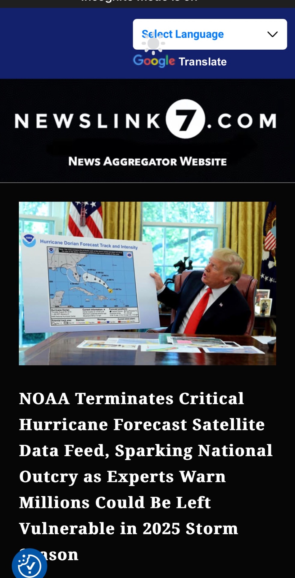
NOAA Terminates Critical Hurricane Forecast Satellite Data Feed, Sparking National Outcry as Experts Warn Millions Could Be Left Vulnerable in 2025 Storm Season
Forecasters warn of life-threatening data loss as hurricane risks grow.
👉 https://NewsLink7.com
#noaa#terminated#forecast#satellite#hurricane#tracking#trump#miami#florida#california#manhattan#orlando#miami beach#broward#new jersey#newslink7#coral gables#ft lauderdale#fort myers#southbeach#tampa#florida keys#tallahassee#louisiana#texas#hialeah#losangeles#san francisco#austin texas#miami dade
7 notes
·
View notes
Text
Good morning, I am requesting to see Karen Wilson doing more fun science-y things in season 8🙏🏾.
I want to see her in her lab. I want to see her talking about some outlandish physics formula or equation and the rest of the group just nodding politely while not grasping a single concept, but Hen is just staring at her with heart eyes.
#Karen my beloved black woman in STEM#that scene in treasure hunt when Hen says Karen created an algorithm to track satellites#award worthy#karen wilson#henren#911 abc
16 notes
·
View notes
Text
do you ship it?


#scwp do you ship it#crossover ship#team starkid#hatchetfield#pulp musicals#nightmare time#nmt2#the brick satellite#the ghosts of antikythera#the searcher in the shadows#the witch in the web#killer track#miss holloway x sia#miss holloway#sia pulp musicals
6 notes
·
View notes
Text
#First National Space Day#India's Space Story#Sustainable development#Network for Space Object Tracking and Analysis#Space Situational Awareness (SSA)#Polar Satellite#South Asia Satellite
1 note
·
View note
Text
sometimes i post about missing old tech and briefly think "aw shit am i a poser" and then remember no growing up like i did means i really did use old tech like that well past its prime because it was cheap as fuck
#i had a cd player well into like. 2010?#only got a cheap mp3 player in 2014 because they'd reached dollar bin status by then#house used vhs until ~2011 when they'd all rotted/been played to unusability (though we had some dvds from 200...7? on#my first computer was a 1990's satellite. dunno the model but it was gray and had a green mouse nipple#i don't think it had a track pad but i don't remember#morrisounds
5 notes
·
View notes
Text
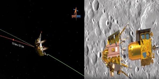
भारत के चंद्रयान लैंडर के 23 अगस्त को चंद्रमा पर सॉफ्ट लैंडिंग की उम्मीद
Chandrayaan News Update। भारत के चंद्रयान-3 मिशन के लैंडर के 23 अगस्त को चंद्रमा पर सॉफ्ट लैंडिंग की उम्मीद है। दूसरी ओर, रूस ने 10 अगस्त को अपना चंद्र मिशन लूना -25 लॉन्च किया, जो 21 अगस्त को चांद के साउथ पोल पर सॉफ्ट लैंडिंग कर सकता है। इस बीच चंद्रयान-3 मिशन को लेकर भारतीय स्पेस रिसर्च ऑर्गनाइजेश के पूर्व प्रमुख के सिवन ने कहा है कि भारत के मंगल मिशन की लागत बेशक कुछ हॉलीवुड फिल्मों की तुलना…
View On WordPress
#chandrayaan 3#chandrayaan 3 deboosting#chandrayaan 3 landing time#chandrayaan 3 live isro youtube#chandrayaan 3 live location map satellite view#chandrayaan 3 live location today#chandrayaan 3 live status today#chandrayaan 3 live status today in hindi#chandrayaan 3 live tracking#chandrayaan 3 live tracking today#chandrayaan 3 news today in hindi#chandrayaan 3 status tamil#chandrayaan 3 update in marathi#chandrayaan 3 update landing date#chandrayaan 3 update today live in hindi#Chandrayaan-3 latest update#isro chandrayaan 3 live tracker#vikram lander chandrayaan 3#चंद्रयान 3#चंद्रयान 3 लाइव ट्रैकर#चंद्रयान-3 अभी कहां है#चंद्रयान-3 कब तक पहुंचेगा#चंद्रयान-3 मिशन#चंद्रयान-3 मिशन Live#चंद्रयान-3 लाइव अपडेट
3 notes
·
View notes
Text
The Complete Guide To GPS Satellite Trackers
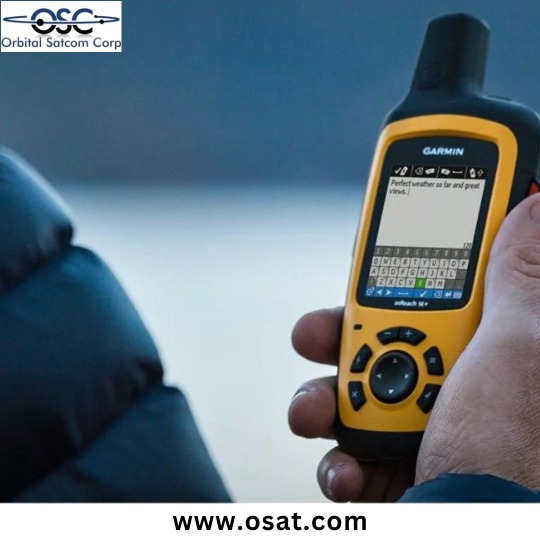
Satellite GPS trackers, exemplified by the cutting-edge Iridium Edge Solar, have revolutionized tracking solutions. These advanced devices provide real-time tracking capabilities, ensuring that you can monitor and safeguard your assets, vehicles, or loved ones, no matter where they are in the world. With the versatility of satellite tracking, you gain precise and dependable location data, making it invaluable for logistics optimization, asset security, or personal peace of mind.
Satellite trackers like the Iridium Edge Solar offer exceptional performance and reliability, even in remote and off-grid environments. Moreover, the commitment to safety and preparedness is evident through OSAT, ensuring users are well-equipped to harness the full potential of their satellite GPS tracker. Explore the world with confidence, knowing you have a powerful tracking companion by your side.
Read this blog to know more:- https://osat.com/blogs/blog/the-ultimate-guide-to-satellite-gps-trackers
#Satellite tracking#Iridium Edge Solar#Satellite GPS tracker#Satellite tracker#Personal Satellite Trackers#Global satellite tracker#Orbital Satcom#OSAT
0 notes
Text
I’ll never forget the college ecology course I took that had us stay overnight at a nature preserve over two hours outside the city, in the rural area where I grew up (bortle 3-4), when several students expressed absolute dumbfounded disbelief when I explained that the “clouds” they were seeing on the clear, moonless night were actually parts of the Milky Way galaxy. Back then I felt a triumphant sense of self-righteousness at having knowledge that at lot of the suburbanite, “city slicker” pre-meds in my course did not possess.
A decade of maturity later, it’s much easier to acknowledge and understand it as the pure, uncontested tragedy I was witnessing. Capitalism has unwittingly robbed humanity of a vital part of the universe we evolved to live in.
I think one big reason why we don't consider the stars as important as before (not even pop-astrology anymore cares about the stars or the sky on itself, just the signs deprived of context) is because of light pollution.
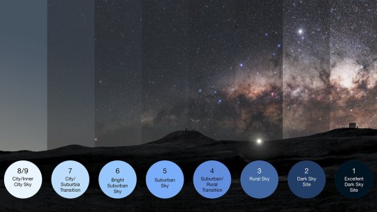
For most of human history the sky looked between 1-3, 4 at most. And then all of a sudden with electrification it was gone (I'm lucky if I get 6 in my small city). The first time I saw the Milky Way fully as a kid was a spiritual experience, I was almost scared on how BRIGHT it was, it felt like someone was looking back at me. You don't get that at all with modern light pollution.
When most people talk about stargazing nowadays they think about watching about a couple of bright dots. The stars are really, really not like that. The unpolluted night sky is a festival of fireworks. There is nothing like it.
124K notes
·
View notes