#antarctic fossil map
Explore tagged Tumblr posts
Visit Tumblr Blog
Explore Tumblr blogs with no restrictions, modern design and the best experience.
Last Seen Tumblr Blogs


Fun Fact
Women make up for the other 50% of Tumblr’s audience.
Text
Lost World Under Antarctica: 34-Million-Year-Old Rainforest Discovered Beneath the Ice
A preserved prehistoric ecosystem buried beneath over a mile of East Antarctic ice is rewriting climate history — and revealing Earth’s next tipping point. In a shocking breakthrough, researchers have uncovered a massive ancient landscape — complete with rivers, ridges, and forests — frozen in place beneath Antarctica’s Wilkes Land. Sealed off for over 34 million years, the untouched terrain is…
#ancient antarctic rainforest#antarctic fossil map#antarctica lost world#buried ecosystem#east antarctic ice sheet#frozen time capsule#Lost World#palm trees in antarctica#prehistoric climate change#rivers under antarctica#wilkes land discovery
0 notes
Text
Basler to the Beardmore 2: Errands
As always, no matter what Tumblr does with it, this post is available in its intended presentation at twirlynoodle.com/blog along with the rest of my Antarctic travel diary.
On this flight to the heart of Antarctica, I was only a hanger-on. We had two errands to run before entertaining me and my historical interests, the most important of which was restocking a fuel depot at the base of the Transantarctic Mountains.
There are many busy science teams in Antarctica, and while some renewable energy sources are starting to be used, the fact is that everything runs on a reliable supply of fossil fuels, mostly petrol. The aircraft that keep people and their essentials moving around the continent have a network of fuel depots, both for relay stops and for emergencies. Contrary to some conspiracy theories, anyone can fly to and around Antarctica if they have the money and resources to get there, and many do. As the national science programmes have a very tight margin, and their fuel depots are expensive to maintain, they cannot afford jet-setters raiding their supplies, so the locations of these depots are kept secret. Therefore I am not going to tell you where our first stop was. The chances of a private pilot reading this blog are slim, but it may be possible to deduce from my photos where this particular cache is: if you are that outlier, I hereby ask you please to do the decent thing and leave the fuel alone – or if you absolutely must access it, then let the USAP know what you've taken and make good on it as soon as you can. Everyone in Antarctica looks out for each other, and that includes you. OK? OK.
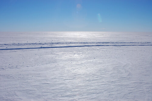
So, we've taken off, and done our acrobatics to get the skis up, and are now facing a couple of hours' flight time before we reach our primary destination. There is, quite frankly, nothing between Williams Field and the Transantarctic Mountains, besides hundreds of miles of the Ross Ice Shelf. This was known as 'The Barrier' to the early explorers, because when James Clark Ross sailed down to explore in 1840 it was a great while wall that prevented his ships from going any further. In later years it wasn't so much a barrier as a highway – clear and flat, and not much off sea level, it provided a route deep into the high latitudes without the perils of the high windy Polar Plateau. Among people who frequently travel out there, it is sometimes referred to as 'the Flat White' – my impression is that this term came from the Kiwis, and the espresso drink of the same name is also antipodean in origin, so I wonder which came first. It is undeniably Flat, and White (though the refraction of sunlight through ice crystals makes it look anything from peachy to periwinkle, depending on the angle), but none of its various names communicate just how big it is.
I have flown over the Canadian tundra many times, and over the Greenland ice cap, but the view from 35,000 feet is like looking at satellite view in Google Maps compared to flying at cloud level, where the parallax with the horizon gives you a much keener sense of distance. The Barrier is BIG. In fact, 'big' is too small a word to communicate it. 'Massive', 'mammoth', and 'gargantuan' are more melodramatic than descriptive. Its vastness puts all of human consciousness, never mind vocabulary, in proper perspective. For my money, it outdoes the night sky as a visual approximation of infinity.
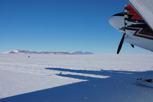
Getting a sense of its size, especially in a still photo, is difficult without an object for scale. For your education and my good fortune, we happened to fly over the RAID convoy as they made their way from the Minna Bluff site to where the Ross Ice Shelf meets the Antarctic continent. Rapid Access Ice Drilling has been supporting various scientific projects for a few years now, whether their interest is in the ice itself (its trapped air gives a record of Earth's atmosphere in millennia past) or what's underneath (marine environments far removed from the open sea; the bed of an accelerating glacier). Their units are about the size of a shipping container, and are pulled by enormous tractors, so if they are this dwarfed by the Flat White, imagine how much more puny a sledge party would be.
Before too much longer we were at the depot. Landing at an Antarctic field airstrip is even more complicated than taking off: we circled once, to do a visual check, then skimmed it with the skis to make sure no hidden crevasses had opened up since the last time someone landed here, then finally touched down for real on the third go-round. The plane crew rapidly got to work unloading the fuel drums; I offered to help but was assured I wasn't needed, so spent the time taking photographs and mucking around in the snow.

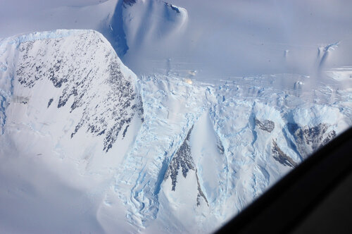
The first thing that struck me was how beautiful the mountains were in colour. The best photos I've seen of them have been black and white, so the rich variety in shades was remarkable. What you can't see in this small photo was how the lighter rock was banded with strata of blue-grey and orange-brown sandstone, giving it a luxurious marbled effect.
I've read a lot about how conditions on the Barrier are so much different than on the coast. This was far deeper into it than I was ever expecting to set foot, but I was surprised how tame it was. Now, it was an idyllically calm and sunny day – had it been any different we would not have been there – so the only time I realised that it was actually much colder than McMurdo was when a slight breeze wafted past my bare hand and broke the warm spell that the sunshine had cast.
What was different was the snow. Around McMurdo, the snowbanks which did build up had been repeatedly blown over with volcanic dust which warmed up in the sun and made the snow gritty, icy, and rotten – if you live in a snowy city, think of the texture of snowbanks alongside busy roads. Out here, there was nothing but snow, all the way down to where it became ice – powder blown off the mountains, maybe even off the Polar Plateau, deposited here to be compacted in the sun and polished by the wind. The crust made by these processes was smooth and, in many places, thick enough to support my weight, so I hardly left a footprint – a 'good pulling surface' as sledgers would have it – but without warning there would be a thin spot where my foot would break through and sink in the sugar-like snow below.
Before long, the crew had finished their restock, and playtime was over. After our exciting takeoff manoeuvres, we started climbing the mountains to the second of our tasks for the day.
The Transantarctic Mountains, according to our pilot, are still something of a mystery. They are a very high mountain range, but unlike the Rockies for example, they show little or no sign of buckling or other geological forces – they seem to have been lifted whole, keeping their layers of sandstone and coal and fossil-rich deposits mostly flat, with occasional intrusions of igneous rock. The range acts as a sort of massively oversized dyke, holding back the miles-deep polar ice cap from spilling over West Antarctica, the Ross Ice Shelf, and the Ross Sea, as the mountains cross the continent.
Ice appears to be solid, but it actually behaves more like a stiff jelly or fondant icing – if it finds a change in altitude it will flow, very slowly, downhill. This is what a glacier is: snow gets deposited over many years without melting, turns to ice, and when its volume can no longer be held at elevation, starts to creep down the valley. The ice of the Polar Plateau finds gaps in the Transantarctic Mountains and pushes through them, forming glaciers which pour out onto the Ross Sea and, merging, form the Ross Ice Shelf. The Beardmore Glacier is one of the largest of these, but there are hundreds of smaller ones, and many tributary glaciers that feed these. In flying over the lower Transantarctic Mountains, there were plenty of opportunities to see ice dynamics at work:
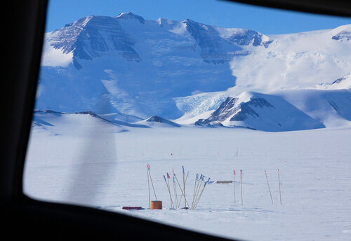
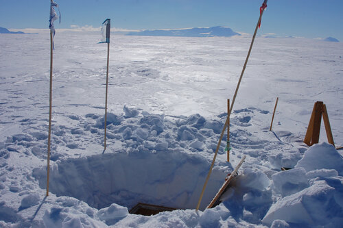
Our destination was up near the head of a narrow glacier, where it broadened out into a snowy plain called the Bowden Névé – névé being a term for young snow which has not yet compacted into glacial ice but is in a position to do so. This was CTAM (pronounced see-tam), a geology camp established to be a hub for teams doing work in the Central TransAntarctic Mountains. The névé afforded an open, soft, flat place to land planes carrying supplies and people, who could then move on to less accessible places overland. At least, it did, until a wind event a few years ago scoured deep furrows in the landing strip.
As we flew over, doing the visual check, I was astonished the site could be spotted at all, as it was only a small clutch of bamboo poles in the vast expanse.
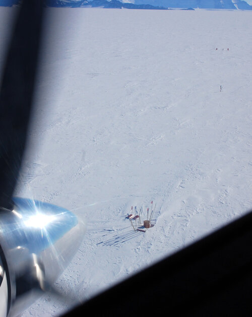
Having proven that the landing strip was landable, the next task was to see what condition the building was in. What building, you ask? Why, the one completely covered in snow, under the markers. Once upon a time it was a couple of modules standing on the surface of the glacier, but Antarctica gradually swallowed them up, so now one has to dig down through the snow to reach the roof hatch, eight feet above the floor.
On the way from the Basler to the camp site, I was treated to one signature snow effect I had missed out on, at the depot. 'The Barrier Hush' is frequently mentioned in journals: it was described as a 'whoosh' or a 'hush-shh-shhhh' that sighed out from underneath the walker as he broke through the top crust into a pocket of air underneath, where the loose snow had settled after the top crust was formed. The pocket could sometimes extend quite a long way from where the crust was broken and the sound followed the exchange of air as far as it went. It would startle the ponies and excite the dogs, until they learned there was nothing to chase and catch.
I was walking some way behind the plane crew as they made for the camp with shovels, and suddenly heard what I thought was a small whirlwind – a sharp and intense, almost whistling sound that seemed to race across my path. This being the sort of place one would expect to see dust devils (or snow devils, I suppose they would be) I looked around to see where it was, but the air was as still up here as it had been down on the ice shelf. It was only after the second or third time it happened that I realised what it was – it was so completely not how I had imagined the Barrier Hush to sound. If you make a little whirlwind sound by whisper-whistling whshwshywshwhwwsh with your lips really quickly, that's what it sounded like. Having heard it, now, I can completely understand how the dogs would have thought there was a small creature scurrying around under the snow. It sounded much more animate than it had been described. I felt so lucky to be let into that secret.
The crew got the hatch open and the first of them climbed down into the pitch darkness to report everything OK. The rest followed, and invited me along, but I am not the most coordinated travelling artist, and couldn't see a way down for me that didn't end in a concussion. So I stayed above while they explored the submerged camp, and enjoyed the view. It was really spectacular – not just the stunning mountains but the thin, brittle blue of the sky and the hardness of the sunlight, as if the whole world were a taut drumskin.
And, best of all, from here the horizon was the Polar Plateau – another Flat White stretching to the South Pole and beyond.
#antarctica#travel#basler#dc3#CTAM#air freight#mountains#transantarctic mountains#bowden neve#geology#field camp#photos
58 notes
·
View notes
Text
The Forgotten American Explorer Who Discovered Huge Parts of Antarctica
https://sciencespies.com/nature/the-forgotten-american-explorer-who-discovered-huge-parts-of-antarctica/
The Forgotten American Explorer Who Discovered Huge Parts of Antarctica

The early-1900s exploits of intrepid explorers like Robert Scott and Edward Shackleton captured the public imagination. With the benefit of cameras and deft handling of newspaper media, the Edwardian British explorers, alongside their Norwegian rival Roald Amundsen, established themselves as heroic polar pioneers. In the process, however, the south polar exploits of their American forerunner, Charles Wilkes, have been largely forgotten.
It was the round-the-world expedition by Wilkes—whose scientific collection constituted the first treasures of the infant Smithsonian—that first established the continental dimensions of Antarctica. But in a twist of 19th-century international politics, that claim to Antarctica was denied to the Americans by the pole-hungry British. Fast forward to today, and the United States finds itself in another nationalistic race to capitalize on the frozen southern continent. This time, its sparring partner is China.
Amundsen might have been the first man to reach the South Pole, in 1911, but the discovery of the Antarctic continent occurred several generations earlier. In January 1840, when Wilkes was commander of the United States Exploring Expedition, he charted 1500 miles of the east Antarctic coastline in his flagship U.S.S. Vincennes. Before this American expedition, only small, rocky outcrops of Antarctica had been sighted. Most exploreres believed an open polar sea or, at most, a scattered archipelago lay at the planet’s far south.
In a remarkable coincidence, a French expedition led by the legendary Jules Dumont D’Urville reached the same stretch of coastline on the same day. But D’Urville stayed just long enough to plant the French flag on a tiny offshore island before sailing back north. Wilkes, meanwhile, against the advice of his medical staff and officers, braved the cold, ice, and howling katabatic winds to claim glory for the Vincennes.
Charles Wilkes barely had time to announce his Antarctic triumph before British rival James Clark Ross (celebrated discoverer of the North Magnetic Pole) began to steal his thunder. Wilkes’s mistake was to send the lagging Ross his historic first chart of the east Antarctic coast. A year later, when Ross retraced Wilkes’s route, he found the American had been deceived in places by glacial reflections and had mistaken ice shelves for actual coastline, marking it several degrees too far north. These errors did nothing to undermine the substance of Wilkes’s discoveries, yet Ross and the British Admiralty built a public case against the American claim—with great success. Most 19th-century maps of Antarctica do not recognize Wilkes’s remarkable 1840 feat. Even his obituaries in American newspapers made only passing mention of Wilkes’ polar discoveries.

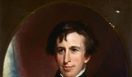
Lieutenant Charles Wilkes, commander of the United States Exploring Expedition, 1838 to 1842
(Thomas Sully, U.S. Naval Academy Museum)
In the 20th century, Wilkes would finally get his due. In 1912-13, Australian explorer Douglas Mawson was the first to revisit the east Antarctic shores mapped by the Vincennes. Mawson so admired Wilkes’ navigation of the ice pack in a wooden sailing ship that he christened the entire coast “Wilkes Land,” which remains the largest continuous territory on Earth named for a single individual.
Wilkes’ rehabilitation reflected the changing power dynamics of the polar great game. The British and French eventually ceded the argument, and corresponding territory, to the United States as the world’s emerging polar power. During the Cold War, the United States continued to assert its leadership in Antarctic affairs, brokering the international Antarctic Treaty of 1958 and investing in cutting-edge polar research. Much of what we know about climate change, for instance, comes from secrets revealed in drilling Antarctic ice cores, an outgrowth of America’s interest in polar science.
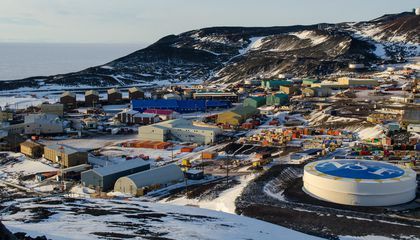
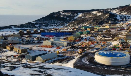

2015 photograph of McMurdo station, Antarctica
(Mike Lucibella, NSF)
Today, the Antarctic landscape is changing—and not just from melting glaciers. America’s interest in Antarctica appears to be waning, and so too is its influence.
In the decade following the 2008 global recession, funding for the Office of Polar Programs, which oversees American facilities and research in Antarctica, fell by 8 percent. Plans for the long-overdue replacement of aging facilities at McMurdo Station, the United States’ Antarctic headquarters, were drawn up during the Obama administration, but a further proposed cut of more than 10 percent in the 2021 budget places those rebuilding plans in jeopardy just as work is set to begin. Without modernization of McMurdo, which in its size and sophistication has long been the envy of other nations, the perception of America’s declining interest in Antarctica will grow.
China, long relegated to spectator status in Antarctic affairs, stands to gain the most. With four Antarctic stations already, China is now in the advanced planning stages for a fifth station—this one to be located in the heart of “downtown” Antarctica, on an island in the Ross Sea adjacent to McMurdo. The image of a rusting, outdated American station alongside a gleaming, state-of-the-art Chinese facility will communicate more clearly than a hundred polar policy papers the reality of the power transfer already under way in Antarctica, where China’s investments in icebreakers, communications hardware, and station infrastructure dwarfs that of other nations, including the United States.

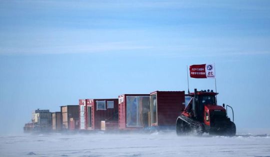

China’s 35th Antarctic expedition sends 37 members of two inland expedition teams to the Kunlun and Taishan stations in Antarctica Dec. 18, 2018.
(Xinhua News Agency / Getty Images)
The French, British, and American expeditions of the 1840s sailed south in the hope of discovering a Terra Australis laden with mineral treasures, only to find towering glaciers and deathly cold. A couple of centuries later, it’s China that is determined to reap Antarctica’s mineral riches.
As the northern ice melts, the Arctic Ocean is already the scene of international jockeying for mining rights. But as China scholar Anne-Marie Brady has documented extensively, Beijing views Antarctica as the last great terrestrial frontier on Earth, hosting great deposits of coal, natural gas, precious minerals, added to plentiful fish stocks in the surrounding ocean and even vast freshwater reserves locked up in Antarctic ice. China intends to exploit the continent fully once the current Antarctic Treaty expires in 2048, if not sooner. With nations hungry for new sources of oil and mineral wealth, and China laying the groundwork for industrialization of the pole, the stakes for Antarctica couldn’t be higher.
An obvious irony looms over this new Antarctic rush. If Antarctic glaciers are already melting, and the consequent sea-level rise threatens to inundate coastal cities across the globe, why would any government make plans to exacerbate global warming by exploiting fossil fuel reserves in Antarctica? Will the 21st century end with oil fields in an ice-free Wilkes Land or strip-mining in the forested Transantarctic Mountains that are currently buried in ice? It seems outlandish, but this is exactly the future that Beijing’s plan could trigger, even if public pronouncements from China conform to the diplomatic polar language of international collaboration and disinterested scientific research.
As the nation with the greatest historical investment in Antarctica, the U.S. has the resources and authority to lead an international re-commitment to south polar conservation. By reaffirming its leadership role at the pole, America can ensure that the great game of the 21ar century does not repeat the mistakes of those of centuries prior, when the world’s pristine frontiers were fought over and ransacked with little thought for environmental damage, or for what future human generations might do once the last wilderness on Earth melts away.
This story is adapted from the author’s new book Land of Wondrous Cold: The Race to Discover Antarctica and Discover the Secrets of its Ice.
#Nature
#03-2020 Science News#2020 Science News#Cannon#Earth Environment#earth science#Environment and Nature#Nature Science#News Science Spies#Our Nature#outrageous acts of science#planetary science#Science#Science Channel#science documentary#Science News#Science Spies#Science Spies News#Space Physics & Nature#Space Science#Nature
1 note
·
View note
Text
On Mars
Things I love about Mars: the landscape.
Mars's landscape is both alien and familiar. There are other fascinating landscapes in the Solar System, of course: Venus, Pluto, Europa, Titan, etc., and each has their charms; but the thing about those landscapes is that the environment in which they're found makes them more alien. Venus has mountains and plains and, like Earth, few craters; but the crushing sulphuric pressure of the atmosphere and the fact that every few hundred million years it seems the entire planet may go molten and resurface itself makes Venus a setting for hard SF, or individualistic person-versus-environment stories: the narrative that suggests itself to me when I imagine standing (in some megaspacesuit) on the surface of Venus is not "this is a place humans could one day be," but "this is an unpeopled Hell."
(Also: apparently Venus may have had liquid water as recently as 700 MYA. Life on Earth seems to have arisen almost immediately, as soon as the conditions potentially favorable to it existed. From the formation of its oceans to 700 MYA, Venus would have been climactically stable, thanks to higher cloud cover than Earth. So it is entirely possible that for a couple of billion years, between the oceans of Venus forming and the runaway greenhouse effect destroying them several hundred MYA, Venus had life, up until the Neoproterozoic period on Earth. But if the theories regarding how energy is released into Venus's dessicated crust are correct, the fossil evidence of that life would have been annihilated in the same event that resurfaced the entire planet some time in its geolocially recent past. Perhaps fragments of it persist, floating deep in the mantle like the Farallon plate on Earth--but for now, an actual record of the biohistory of Venus is lost to us. What I'm saying is, Venus is a postapocalypse: not a hopeful Perelandra, not even in the far future, but a grievous memorial for what might have been our lush and gardenlike neighbor.)
Titan, Europa, and Pluto--although they have very different landscapes--have a common feature, which is that waste heat from technology (heck, from human bodies) would melt or boil their surfaces. Pluto is especially bad in this regard, given that its plains are 98% nitrogen ice. Humans on Pluto would be creatures of unquenchable fire, destroying everything they touched. Europa is much more familiar, especially if it has warm seas beneath the ice; but its landscape is a vast broken plain of ice, possibly with a band of peninent spires rising into the sky at the equator. It's metal as fuck. But the airless, radiation-bathed surface is, again, seems to be suited mostly to being a vehicle of existential exploration, and the subsurface ocean may just be a hopeful dream, like the jungles of Venus. Titan, that weird little orange goofball, also has a water ice surface, plus a hydrocarbon "hydrosphere" which is fascinating! It's the first time the IAU has had to come up with a naming convention for actual bodies of liquid on a planet's surface. It has lakes! Inlets! Seas! But it's tiny, has very little gravity, and if you tried to terraform it even a little bit the entire thing would melt or evaporate. There are stories I would happily tell on Titan. I can even imagine they would have some features of the stories I would tell of an Earthlike world: here is a political boundary following a river, here are pirates on the Ligeia Mare (pirates on a methane sea, frost condenses on the inside of the hull even through half a meter of insulation, we haven't seen sunlight in weeks, we haven’t seen the sun since we were born). But the strictures of the environment also demand a more hard-SF sensibility, and a hard-SF sensibility applied to the "soft" aspects of science fiction: how do the constraints of the environment shape how societies function? How is politics, war, and economics different in a place where atomic individualism isn't just maladaptive, but maybe impossible? I've thought about these questions in other contexts (deep space, settlements on airless rocks), and although Titan expands the possibilities somewhat, it doesn't expand them much. But it's definitely my third favorite body in the Solar System (after Mars and, of course, Earth).
[Ligeia Mare, the second-largest lake on Titan, 78° N, 249° W .]
The rest of the solar system is either gas giants (which fill me with too much dread to really apprehend them on an immediate or aesthetic level; what hubris is it to try to imagine a little human soul against the endless storms of Jupiter?), or small, airless bodies specked with craters. Some of these verge on the utterly uninteresting. Io is at least respectably garish. But the narrative context they suggest to me is the same as Titan, shorn of the unique geographical points of interest that moon offers, and while that doesn't mean they're not interesting, they don't excite me nearly as much. I am glad they exist. Some are really beautiful (speckled Ganymede! gleaming Eceladus, Europa's twin! what the fuck is wrong with you Iapetus!).
(What did we do as a species to deserve a Solar System full of so many different, beautiful worlds? How much wonder is there in the rest of the Universe if this little corner is already so full of it?)
But Mars. Ah, Mars. You know, my head says that interplanetary colonization would be a waste of resources and, lacking a useful economic purpose, ultimately a giant boondoggle. There are inhospitable environments on Earth that are, against Mars, an Eden, and we have yet to people them; if science is our aim, even the practical benefits of a manned mission to Mars stop at orbiting the planet and controlling robots remotely below. And I know all this. But there's a quiet voice in the back of my head--quiet only because like the rumble of distant thunder it is spoken at much deeper frequencies, frequencies of the ground beneath my feet and of my soul itself--that says if I don't die having crunched the grit of Mars beneath my feet or run its dust between my fingers, my life will have been empty and devoid of purpose. Not to get too metaphysical on you, but I'm pretty sure there's a part of my soul that is convinced it was meant to be born on Mars, meant to wander the Kasei Valles and the Tharsis plateau, that longs to stand on the Olympus Rupes and watch the dust storms on the Amazonia Planitia below; to sojourn in the Labyrinth of the Night, filled with fog from sublimating frost.
Mars is alien. Mars is not like Earth. Yet its appearance suggests a world we almost know: here are canyons, here are sinuous valleys, here are dusty plains. On closer inspection, these things reveal their true, unearthly nature: this is a canyon as long as Europe, yawning deeper than the mountains rise. This is a volcano, yes--it is the size of France. If you stood on its summit, very nearly above the top of Mars' atmosphere (which is taller than Earth's!), its slopes would disappear around the curve of the world before you saw their end. These valleys are not river valleys: they are ancient outburst channels, the catastrophe that scoured out the Channeled Scablands--over, and over, and over again. The atmosphere is gasping-thin, and often choked with dust. The surface is freezing. Nothing lives, not so far as we can tell. But you can imagine yourself there. I wonder why?
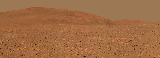
[The informally-named “Columbia Hills,” Gusev Crater, Mars, 14.5°S 175.4°E. Mosaic image taken by the Spirit rover. The distance is about 300 meters to the base of the hills.]
Part of it, of course, is the wonderfully detailed photography from Mars missions, and the fact the planet is extensively mapped--one of the best-mapped bodied in the Solar System. As part of the Inner Solar System, we can orbit it comparatively easily, and we don't have to rely on photos snapped during quick flybys. (The USGS has complete, detailed maps of Mars available for free! The USGS is a freakin’ international treasure.) I think Mars more easily than most worlds in the Solar System is a canvas onto which we can imagine projecting the psychodramas of our own history. If the "minor" objections of its ultrafreezing surface and its unbreathable, thin atmosphere can be overcome, we can almost imagine it like any other harsh desert into which human habitation has intruded (and humans, like a gas, do tend to occupy all available space). And those objections can be overcome, if we are patient and work very hard, and they can be overcome without annihilating the surface of the world. It would be possible to blanket Mars in a thick, carbon dioxide-rich atmosphere and bring its temperature up to, say, Antarctic levels (i.e., you could survive indefinitely in very warm clothing with a breathing apparatus) with several centuries or possibly a millennium of the diligent application of existing technology. We have no reason to do it right now, and it would be madness to try, but it's doable--so one day, we might.
And if we did? Well, I'd like to think that the species that did that would be, after Carl Sagan, a species very like us but slightly better in important ways, and that by then Earth would be a much nicer place to live; and Mars, therefore, by extension, would be a more rugged and difficult environment but still full of basically decent people who have solved problems like poverty and oppression and large-scale warfare. With a light brushing of a sort of Mad Max visual aesthetic, what with all the breathing masks and the exposed ductwork. Hopefully they would continue the IAU trend of giving everything really atmospheric names, so we wouldn't have the place carpeted in stupid shit like "New Canada" and "President Reagan Land", like Antarctica has been. (Seriously, the IAU needs to take over naming stuff in Antarctica, it's dire down there.)
There is another possibility of course, and in my mind that possibility is inextricably linked with the fact that Mars is small. Mars, like Earth and Venus, probably formed with a dense atmosphere. Its coldness, believe it or not, is not a feature of its distance from the Sun. That's a common misconception. The approximate habitable zone of a G-type star like the Sun extends from within the orbit of Venus to just to, or slightly beyond, a planet at Mars's distance (1.5 AU or so). Venus, for its part, was doomed by being just too warm, and, as the Sun aged and its energy output increased, the homeostasis of its environment being tipped a little bit too far, until the whole thing collapsed, the seas evaporated, and the water vapor was shorn apart by ultraviolet energy, its hydrogen scattered into space by solar wind. But Venus is big. Venus could hold on to its atmosphere regardless. Mars could not. Though further from the Sun, and initially with its own hydrosphere (which now sleeps frozen beneath its crust and at the poles--which have enough water in them to deluge the surface meters deep), the solar wind gradually stripped away Mars's atmosphere, until it was unable to trap heat, and liquid water ceased to be able to exist on its surface for more than the briefest periods of time. Earth, too, would be frozen desert if it had an atmosphere like Mars.
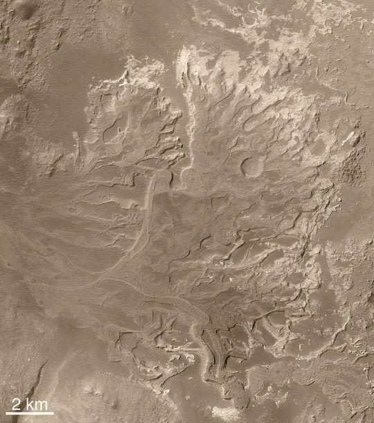
[A Noachian-era alluvial fan in Eberswalde Crater, 24°S, 33°W . Many Noachian-era craters show evidence of having once been filled with water. The aptly-named Noachian period was the last time surface water might have been abundant on Mars, and ended roughly 3.7 billion years ago.]
Any atmosphere we give Mars is doomed in the long run--on the order of thousands of years, not millions. Any civilization we engender on Mars is not a civilization for eternity: it is doomed from its beginning. If we are less wise than we hope, less able to cooperate than we wish, less able to accomplish the miracles of terraforming that we require, the saga of human habitation on Mars will not be the saga of overcoming the frontier, of planting a new, bright tree of our people on a neighboring world; it will be a saga of a promising beginning and then a long--terribly long--slow decline. The Martian desert will slowly cover cities and whatever little groves of life we plant; our first, tentative seas will dry up; increasing scarcity will become the norm, not for a few generations, but for whole civilizations, until the entire memory of the world is nothing but a medieval feeling of decline, of loss, of some ancient glory which we cannot quite remembering being forever beyond our reach. The midcentury scientific romances of a dying Mars were true, but they were not accurate assessments of the present or the past. They were prophecy--a prophecy which is not guaranteed, but which should serve as a warning nonetheless.
Again, my interest in these concepts is mostly from the standpoint of fiction and imagination. Colonization of Mars is a long, long way off, and sitting here in the mythic past of any future Martian civilization, with a warm green spring outside my window and the luxury of breathing free oxygen kindly manufactured for me for free by the native biosphere, I would be surprised if any future settlement of Mars unfolded more than a little bit in the way I expect. Nonetheless, these are the thoughts that occur to me as I pore over maps of Mars. Here, the Chryse Planitia. Here, the graceful curve of the Claritas Fossa. Here, Elysium, its scattered features named for the abodes of the dead. Here, the illimitable Vastitas Borealis. Here, the Chasma Australe, which cuts deep into the southern Martian pole; where Edgar Rice Burroughs might have imagined the ten-thousand mile River Iss. I know that I will probably never see this world with my own two eyes. But God Almighty! I would give anything!
395 notes
·
View notes
Text
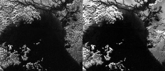
Lost Ice Age Landscapes Buried Under the Seafloor Have Been Mapped by Scientists
Scientists have captured surreal images of bygone ice age landscapes that are now buried under the seafloor between Great Britain and northern Europe.
The ancient scenery includes enormous meltwater channels, called tunnel valleys, that were originally probed by sophisticated seismic surveys on behalf of oil and gas companies. A team led by James Kirkham, a PhD student at the British Antarctic Survey (BAS), have used the unprecedented data to peer back in time at ice ages over the past million years, a record that contains important clues about how modern ice sheets could respond to human-driven climate change.
The team’s research “marks the first time that abundant glacial landforms have been convincingly imaged within buried [tunnel valleys] in the North Sea,” according to a study published on Wednesday in the journal Geology.
“People have identified these channels and mapped them, but we've never before been able to really see the detail of what's inside the channels and how they were filled,” said Robert Larter, a marine geophysicist at the BAS who co-authored the study, in a call.
“When you go back and look at the older 3D seismic data sets, which are lower resolution, it's like looking through fuzzy glasses in comparison to the new data,” he added. “You can see some of these features when you know they are there, but it really is like getting a better pair of spectacles, or going to the optician and getting the right prescription.”
The dramatic images offer a rare look inside massive ice sheets that advanced and receded across the United Kingdom and Europe, and reveal 19 tunnel valleys that range in width from 1,000 feet to nearly two miles. Within these huge rivers, Kirkham and his colleagues were able to discern extremely small features, just a few feet wide, that shed light on the interior drainage mechanisms of the ice sheets.
“These data are fantastic in their detail,” Larter said. “The limitation is that they cover quite small areas, so we can't go out and map the whole of the North Sea in this kind of detail. But we can do process studies looking at a few of these channels and understanding how they formed, which people couldn't do before.”
Scientists have spent decades trying to understand the formation and evolution of channels within modern ice sheets, like those in Greenland or Antarctica, but these efforts have become far more pressing alongside the escalation of human-driven climate change. Warmer temperatures are causing a decline of ice sheets and glaciers that is contributing to sea level rise, among other anthropogenic effects. A more precise understanding of ice sheet interiors could help to predict how these critical structures will transform in the coming centuries.
Given that fossil fuel consumption is the main driver of the climate crisis, and the fact that the data was obtained at the behest of fossil fuel companies investigating offshore oil and gas reserves, Larter called the new study a “swords to ploughshares” approach to resolving questions about climate change.
The fossil fuel industry is “only interested in one thing, really, in the data,” he said, “but there is so much more in 3D seismic data and a lot of university academics make use of it.”
In addition to providing a spectacular view of these buried ancient landscapes, the seismic imagery can fill in some of the gaps in our knowledge of how ice sheets respond to periods of climate change. Far more observations and research will be needed before this kind of data can be directly applied to modern climate projections, but the new study has helped to literally map out the groundwork for those applications.
“We're at an early stage, I think, and there's a long way to go,” Larter said. “But ultimately what we hope is that you will see this incorporated into the sort of models that are doing predictions of how the Antarctic and Greenland ice sheets are going to behave in the future.”
“We now understand better how these things were formed, but there's still a lot more questions than answers,” he concluded. “But that's how research progresses: baby steps.”
Lost Ice Age Landscapes Buried Under the Seafloor Have Been Mapped by Scientists syndicated from https://triviaqaweb.wordpress.com/feed/
0 notes
Text
Monday to Wednesday, 26-28 July
Monday
We had a slow start today, knowing that we were less than 2 hours from Winton. We started by revitalising our fire and cooking eggs and bacon and toasting some of our own bread over the coals and eating it out in the open. It is many years since we did that (if we ever did) but it was fun and delicious - a great way to start the day. By the time we were on the road, a lot of other traffic was too so we basically just drove into Winton, found our caravan park and set up the van. It is not the best park we have stayed in, but we rarely use many of the facilities anyway so it is not a big deal.
We needed a few groceries but shopping is limited in Winton so we didn’t get quite everything we wanted despite raiding both their small supermarkets – including another Spar! We called in at the Information Centre to get some more information about the nearby Dinosaur Exhibition but decided not to pursue it. It sounded pretty crass, a mock-up of what some people guess it might have looked like, rather than any real artifacts or scientific exposé. Of course, I was also interested in what birds were in the area so picked up a brochure advising where to find birds in and around Winton.
What a joke! They referred to Bladensburg National Park but that is huge and we saw and heard very few birds when we visited it. But the main places they recommended were in or close to town. I explored all of them. I had been told that one was ‘out of bounds’ by the staff at the Information Centre, but when I explored two more of them, both were fenced with locked gates and signage threatening dire consequences for any trespassing. Very disappointing. Nothing to see here guys!
In the evening, we did another thing that we don’t usually do. Lots of parks now provide ‘entertainment’ at Happy Hour time, usually a local bush poet or a guitarist who imagines they can sing, and we avoid them with great fervour. But here, they promised a locally well-known poet and comedian at 7pm and we had probably had just enough to drink to entice us over. There were only 3 other couples and 3 kids there but he was really very good. (His name is Gregory North and he has a regular gig at the North Gregory pub!) He writes some of his own stuff, but also does Henry Lawson and Banjo Patterson among others. He did The Man From Snowy River in about 10 ethnicities and accents, changing hats to represent the varying immigrant communities and it was an absolute scream. Brilliant! He also did a very touching one that he wrote about an aging aboriginal man and that was great too.
It was all over by 8pm but it was an unaccustomed pleasure (for us) to sit in on something like that for a change.
Tuesday
We went out to Bladensberg National Park today. We visited it 11 years ago and thought it great and imagined that we had only seen a corner of it so wanted to explore more of it. Unfortunately, it was a disappointment. There is nothing more accessible than what we saw all those years ago and it was mainly hot and dusty with other cars turning up next to us wherever we stopped. We didn’t even see many birds and I recall one of the highlights of our previous visit was our first view of a Spinifex Pigeon. We have seen quite a number of them this trip, but sadly, White-plumed Honeyeaters and Black-faced Woodswallows were all we saw today.
On the way back to the caravan park, we called in at the two other Council-recommended birding sites, but there were very disappointing too. No possible way we would see any interesting birds at either of them. One was a heavily contaminated site (any bird that ignored the signage would potentially have suffered 'dire consequences' from the contamination), and the other was a free-camping site covered from horizon to horizon with caravans (and vehicles speeding from place to place, each trailing its own private dust-storm). Not too inspiring at all!
We called in at the Spar supermarket near our van park to get a few more veges. When we were in Scotland and Ireland, almost all supermarkets were Spars, but this is the only one we have seen outside those areas.
We were obviously a bit naive and starry eyed about visiting Winton again, but it might be somewhere to bypass in future. It is seen as an iconic Outback town, the eastern end of the Great Outback Road, and start of the Matilda Highway amog other things, but for us, it just hasn’t delivered at all this trip.
Wednesday
We spent most of the morning with the air conditioner on in the van avoiding the mid-30 temperatures outside - one of the hottest days since we left home (although we have had quite a few, including those on our camel trek).
We drafted stuff for our blogs and Facebook and I edited a few photos. A few days ago, I inadvertently clicked on something in a suggested 'default box' that has seriously stuffed up the link between my camera, iPhone, iPad and PC, making downloads difficult and creating some confusion when opening .jpgs on my PC - somehow, my PC thinks standard photos are in an unknown format and won’t open them. I have found a few workarounds but it is very frustrating and I seem to have lost 5 days’ photos in the process - but I am still looking for them.
We had one of Heather’s very best omelettes for lunch, a meal-and-a-half in itself and absolutely scrumptious. We then spent an hour or so plotting out our options for travel over the next 3 or 4 weeks. Our Antarctic trip around Christmas has been deferred for at least a year, our NZ expedition and land travel has been cancelled, and with the crazy Covid lockdown in NSW, we have had to cancel our Lightning Ridge Fossil Dig in order to get into the NT and subsequently, WA. We have plotted out an optimistic schedule, but it looks as if we are going to need to spend at least 14 days in the NT in order to get a permit to enter WA. Even then, it all depends on where the virus strikes next!
I went out during the afternoon to find someone who can fit yet another Anderson plug on the van (the fourth this trip) on our way out of town tomorrow. The garage across the road from us here said ‘we don’t do complicated work here’ and referred me to 4 alternative mechanics, three of which I have been unable to find. But we have teed up with the fourth one to fix us up at 10.30 tomorrow morning.
I also called in at the Information Centre to complain about their Birding brochure that highlights the five places to see a great selection of unusual birds that got me excited. But as I said, I was sorely disappointed. The woman at the counter said that 'tourists often don’t read their maps correctly' and assured me that I must have gone to the wrong places. She directed me to the exact places I had visited and sent me away for a better look. I did the rounds again, driving every road in the various localities with the same result. The most contentious one was the sewerage ponds that she insisted are open and unfenced - but I spoke with an old local guy who lives only a couple of hundred metres away and he confirmed that the location she had marked on the map was where I was looking, but the area had been fenced and under lock and key with big Keep Out signage for as long as he could remember. Back at the Information Centre, I explained all of this again and the woman admitted their maps 'contained errors' but maybe they shouldn’t be advertising birdwatching if three of the sites were locked up, one was heavily contaminated and the fifth was a massive free-camping area!!!
Later in the afternoon, we drove down to town to the North Gregory Hotel to hear Gregory North expounding on the Mysteries of Waltzing Matilda. What a fascinating story. He had obviously done a huge amount of research and we were almost drowned in facts (and conjecture) about the origin of the song, the people involved and their links with other well-known historical figures. It was quite spellbinding as well as highly entertaining, all being expounded on the very site of the song’s premiere, where it had its first public performance. He also performed all the verses of Maltzing Watilda again - this time using slightly bastardised Spoonerisms on almost every word. A prodigious effort and utterly hilarious - I would love to get a copy of it - some of the individual clauses were wonderful.
We couldn’t hang around after the show because I had to be back in the van by 6 o’clock to participate in an online Owners' Corporation Committee meeting that went for longer than usual, resulting in a slightly later dinner - another of our spectacular goat curries. Yum!
0 notes
Text
Geografia + Astronomia Vocabs
[ insp. x ]
la geografia: geography geografico: geographic l’atlante geografico (m.): atlas / illustrated volume il nord / il settentrione: North il sud / il meridione: South l’ovest / l’occidente: West l’est / l’oriente: East la Terra / il pianeta Terra: the Earth / planet Earth la terra: land, ground il nucleo (della Terra): the core (of the Earth) la crosta terrestre: earth’s crust la tettonica: tectonics il fossile: the fossil l’acqua: water il cielo: the sky le coordinate (geografiche) (f.): coordinates la cartina / la mappa / la carta: map (= topographical plan) la piantina / la pianta / la cartina: map (= city plan) la longitudine: the longitude la latitudine: the latitude il meridiano: meridian il parallelo: parallel l’equatore: equator il clima: the climate l’altitudine (f.): the altitude la densità: density
astronomia: astronomy i pianeti: planets lo spazio: the space le stelle: the stars la stella cadente: shooting star / falling star la cometa: comet la meteora: meteor l’asteroide (m.): asteroid il cosmo / l’universo: cosmos / the universe la Via Lattea: The Milky Way la galassia: the galaxy il satellite: satellite l’eclissi (f.): eclypse la navicella spaziale: space shuttle il Sole: the sun il tramonto: the sunset il crepuscolo: the sunset / twilight l’alba (f.): the sunrise, the dawn Mercurio: Mercury Marte: Mars Venere: Venus Giove: Jupiter Saturno: Saturn Urano: Uranus Nettuno: Neptune la Luna: the Moon la notte: the night
le terre emerse: lands (lands above the sea) i continenti: continents il subcontinente: sub-continent l’emisfero (m.): hemisphere l’America del Nord: North America (adj: americano: American) l’America del Sud: South America (adj: americano: American) l’Asia: Asia (adj: asiatico: Asian) l’Africa: Africa (adj: africano: African) l’Europa: Europe (adj: europeo: European) l’Australia / l’Oceania: Australia/Oceania (adj: australiano: Australian) l’Antartide: the Antarctic (adj: antartico: Antarctic) l’Artide: the Arctic (adj: artico: Arctic) l’Eurasia: Eurasia il polo Nord: the North Pole il polo Sud: the South Pole il circolo polare: the polar circle la frontiera / il confine: border la Nazione / il Paese: country lo Stato: state la Regione: area la provincia: province, district / suburbs l’isola (f.): the island la penisola: the peninsula
una distesa di acqua: a body of water l’oceano: the ocean l’Oceano Atlantico: Atlantic Ocean l'Oceano Pacifico: Pacific Ocean l’Oceano Indiano: Indian Ocean l'Oceano Artico: Arctic Ocean il mare: the sea il Mar Mediterraneo: the Mediterranean sea il fiume: the river il torrente: the stream, the brook il canale: the canal / sewer lo stretto: the streat il lago: the lake la cascata: the waterfall la baia: the bay la cala / l’insenatura (f.): the cove la diga: the dyke
la montagna: the mountain le Alpi: the Alps gli Appennini: the Apennines la catena montuosa: mountain range il ghiacciaio: the glacier la cima / la vetta / la sommità: summit il vulcano: the volcano l’eruzione vulcanica: the eruption la costa: the coast il litorale: the coastline la spiaggia: the beach la pianura: the plain la valle: the valley la collina: the hill il campo: the field la campagna: the countryside la scogliera: the cliff l’altopiano: plateau la foresta: forest la foresta tropicale: rainforest il bosco: wood il canyon / la gola: canyon la grotta: cave il deserto: desert la salina: saltpan la steppa: steppe la tundra: tundra
#italian vocabulary#parole words#quite long sorry#italian#italian langblr#langblr#its been a while since i wanted to post something like this#thanks for the inspiration!
201 notes
·
View notes
Text
When We Almost Stopped Climate Change
30 years ago, the United States had a chance to stop climate change. Almost nothing stood in the way, except human resistance. What went wrong?
The New York Times released the podcast, When We Almost Stopped Climate Change, that talks about this issue on August 31, 2018. Below are notes take directly from listening to the podcast.
Nathaniel Rich: By the 1950s scientists new about the possibility of climate change. Articles, news, and speakers on educational channels or prime tv were acknowledging greenhouse gases and carbon emissions to be the cause. These all mentioned a rise in temperature that would melt the Arctic ice. But not much attention was paid to it outside of scientific circles until after the next couple of decades.
Rafe Pomerance: A political lobbyist and activist for environmental organizations, came across a paragraph about the environmental impacts of coal use in 1979. This section of the report was devoted to the addressing that coal, and other fossil fuels, would warm the planet through their emissions of carbon dioxide. He is astonished and terrified and assumes he misread something and puts it out of his mind. He said to himself “this just can't be”. It seemed to him to be a transformation of the planet in one sentence. A few days later, Rafe Pomerance comes across an article by Gord McDonald who is warning about the exact same problem. Pomerance proceeds to call and meet McDonald to learn more. After McDonald explains the issue to Pomerance, Pomerance responds to it and asks if he sets up briefings on Capitol Hill, would McDonald tell them what he told him. McDonald agreed. Pomerance believed that if he brought this information to those in power, they will see that action needs to be taken and they will do the responsible thing. Meetings took place with the PA, National Security Council, the State Department, the Council of Environmental Quality, the New York Times, and Frank Press (president science advisor). A very high-level group of scientist issued a report of the whole problem (The Charney Report) in July 1979. To this day, people still look back at this report.
President Raegan: “I think the environmental protection agency in many instances has gone to the extreme” Following this public statement. Raegan proceeded to appoint the worst possible people, who were all anti-environmental people in power. Raegan continues to make statements putting down the climate concern “we’ve got environmentalists who wouldn’t let you build a house unless it looked like a bird’s nest and they must be restrained” and “I think the biggest thing the government could do is to get out of some of its regulations”. The climate issue begins to go off the map and Pomerance doesn’t know what to do as Raegan is beginning to roll everything back to essentially when Teddy Roosevelt was in power.
The Hole in the Ozone: 1985 s British study was published about the level of the ozone above the Antarctic has dramatically declined. A huge hole the size of North America above Antarctica. This stirred up concern about UV rays raising temperatures, damaging farm crops, and increasing sunburn. Almost overnight, there is an enormous amount of public panic. Made it believable that humans could alter the environment on a global scale. Theories arose that pointed the fingers at man-made chemicals. Scientists wanted a worldwide ban on all uses of CFC. By 1987, the Montreal Protocol: the first global-atmospheric-environmental treaty, a landmarked documented achievement by any standard, and becomes a template for a possible global warming solution. Started to ask that if together, they could mobilize the political will required to agree on a strong ozone protocol. This ozone-hole opened the door to the credibility of the climate problem.
Record Heat: Summer of 1988. Global temperatures higher than ever recorded. Drought, health concerns, and apocalyptic headlines. June 1988, Pomerance receives a phone call from James Hansen, a NASA scientist, who is a lead witness in a hearing on Capitol Hill, and tells Pomerance that he is about to make a major statement. “The global warming is now large enough, that we can now ascribe, with a high degree of confidence, a cause and effect relationship to the greenhouse effect”. The effect of what they predicted years ago is now happening. It is no longer theory, it is happening. The record warm period was not normal and not a natural variation.
Results of the Hearing: Hansen become the face of the global warming problem. By the end of 1988, there are 32 new climate bills. The United States is making new policies, Canada is pushing for an international agreement that would control carbon dioxide emissions. A process begins in earnest to formulate a global treaty to prevent catastrophic global warming. “The idea is to convince everyone that all of this isn’t just scientific speculation, its real, and should be a concern.
Election of George H W Bush: Said that the Whitehouse will do something about the problem. Industry begins to brace for new policies. But instead of the global treaty, a divide arises within the Whitehouse. John Sununu became a difficult obstacle. Al Gore calls for another hearing with James Hansen was set to try and convince the rest of the Whitehouse to get on board. Hansen sends his testimony to the Whitehouse for approval and it comes back to him will all sorts of censors and deletions that distort his scientific findings and also additions that make arguments about economic policy that essentially saying that there should be no regulations that at all compromise the economic goals of the country. Instead of fighting the censors, he accepts them and then makes a call to Gore. Gore asks Hansen if he can send this story to the New York Times, and a bombshell story is released that the Whitehouse is trying to censor a NASA scientist. A huge embarrassment to the Whitehouse, to which they have to apologize and claim that the censorship came from a functionary five levels down from the top and shortly thereafter recommit to the international negotiation process for a climate treaty and that the US will furthermore lead the process. The censor came from Sununu himself.
The International Treaty: November 1988, a meeting in the Netherlands that will be the first high-level meeting about the framework for a global treaty on climate change. Every country sends its environmental administer. The US equivalent is the head of PA, William Riley, but Sununu does not trust him and sends an ally as a kind of minder to the meeting to make sure that the US doesn’t accept any kind of binding proposal. Advocates from the US wait outside the meeting as it goes longer than anticipated because they want to bring some attention of the meeting to the media. It wasn’t until the Swedish minister emerges and tells them “your country is fucking this thing up”. Alan Bromley (Sununu’s guy), had refused to endorse any global treaty that has any hard targets or demands any specific emission reductions - the best opportunity that we’ve had for a binding global treaty to prevent climate change falls apart.
Nathaniel Rich: What went wrong? Rich says there is a simple political explanation, which is that the chief of staff, Sununu won this political fight within the Whitehouse. But a big question remains that why was the level of support, of the political and public support for solving the problem not strong enough to overcome the will one man who wasn’t even the president? Questions arise about our ability to grapple meaningfully with a problem of such enormous stakes and a problem whose ramifications wouldn’t be felt for decades. Climate change involves the potential of civilizational death. We don’t like looking that in the face, and we choose not to.
Bush against Climate Change: By 1990, Bush’s entire economic council comes out against climate policy. The oil and gas industry mobilizes on the issue and develops a strategy and a campaign of funding information propaganda that casts doubts on whether climate change was real, discounted human impacts and suggested there was nothing practical to do about it anyway. And ultimately deny climate change exists at all. Fast forward to almost present day - Trump stating all of Obama’s talk of global warming and climate change was a hoax and a “money-making industry” - the politics around the industry become sharply divided. The United States is refusing to believe that one country could even make a difference, so why try? At the same time, sea levels continue to rise and natural disasters are becoming more and more common. Many news reports around the globe are recording heat records, natural disasters, and many more fateful events.
1979-1989: The time when everyone was willing to meet when it was still about science. The window when a relatively gradual intervention would have had major positive benefits. Maybe it would have taken a couple decades to get right but it would have been enough - but now it’s not enough - that window has closed.
Nathaniel Rich on Looking Forward: It is still not too late. There is still time to make a change and plans that present a pretty clear path that works on solving this and keeping temperatures below a 2-degree Celsius rise. What’s lacking is the political will to initiate the transformation of our energy system and global economy that is required to do this. This political will may not arise until we understand the issue in moral terms and until everyone or most people feel the moral obligation to demand action.
The question I’m left with at the end of this podcast is, how do we create the moral obligation within people? Is this something that is at all possible?
This podcast is only 28 minutes long, I highly suggest giving it a listen.
0 notes
Photo

CHAMP- VERMONT
Lake Champlain is a long, narrow body of water situated primarily in Vermont, though sizeable portions of it extend into New York and the Canadian province of Quebec. The lake is named after Samuel de Champlain, a French explorer who mapped much of the area along the Saint Lawrence Seaway and founded the colony of New France.
Like many large bodies of water across the world, Lake Champlain is believed to be the home of a mysterious aquatic monster. Nicknamed Champ, or affectionately “Champy” by locals, the creature is said to be a dark gray or black serpentine beast with a long, swan-like neck and several humps on its back. Fairly typical for lake beasties, really.
According to some sources, legends of a monster living in the lake go back to the original Abenaki peoples who called it Tatoskok. The first known account by a European was in 1819 when a scow captain claimed to have seen a bizarre looking “black monster” that had a head like a “sea horse”, three teeth, onion-colored eyes, a white star on its forehead and a belt of red around its neck. True or not, this incident marked the start of a string of sightings throughout the 19th and 20th centuries. Champ quickly became a popular legend around the Champlain Valley, to the point that in 1873 famous showman P.T. Barnum offered a substantial reward for the beast’s capture.
Perhaps the most famous piece of evidence for Champ was a photo taken in 1977 by Sandra Mansi. According to Mansi, she was at the lake with her fiancée and two children when what appeared to be an animal with a long, swan-like neck suddenly emerged from the water only about 150 feet away. As Sandra and her fiancée scrambled to get the children out of the water, the object appeared to move as if peering around. Sandra snapped a single photo of the thing before it sank back below the waves once more.
The photo very clearly depicts what appears to be the humped back and snake-like head of some sort of creature. While many have claimed that the object in the photo is clearly a living animal, science writer Darren Naish, along with other skeptics, believes it is only a submerged log that briefly bobbed to the surface before sinking again. His Tetrapod Zoology blog has some pretty interesting model images to back up his claim.
Champ, like Nessie and many other lake monsters, is popularly thought to be a surviving plesiosaur. However as a cold-blooded reptile, a plesiosaur would likely not have been able to tolerate the frigid waters of the lake. There is also the fact that plesiosaurs had stiff necks held out straight in front of them, whereas Champ and its cousins often have flexible, swan-like necks. While it’s certainly possible that over millions of years plesiosaurs developed flexible necks and a warm-blooded metabolism, there is actually a more plausible candidate for the monster’s identity (assuming it is a real animal): a long-necked seal.

In his 1968 book “In the Wake of the Sea-Serpents”, cryptozoologist Bernard Heuvelmans postulated that aquatic cryptids could be grouped into nine categories, one of which was a long-necked seal. But even before Heuvelmans, C.A. Oudemans wrote in his 1892 book The Great Sea Serpent” of his theory that sea and lake monsters were actually a kind of swan-necked pinniped (the group of animals to which seals belong along with sea lions and walruses). Even earlier than this, though, comes a description of a long-necked seal in James Parsons 1751 “A dissertation upon the Class of the Phocae Marinae” in which he apparently makes a scientific description based on what appears to be an actual specimen in his possession (a specimen which has, naturally, disappeared).
There is actual fossil evidence for long-necked seals. Acrophoca longirostris is a pinniped from the Miocene and Pliocene coast of Argentina and Chile that has a remarkably elongated neck. Although its length is nowhere near the plesiosaur-level length of reported lake monsters, it does provide a tentative clue to the existence of long-necked seals.
It’s worth noting that one of the closest living relatives of Acrophoca is believed to be the leopard seal, Hydrurga leptonyx, an Antarctic predator that has an eerie, almost reptilian appearance. If a possible Acrophoca descendant bore a similar appearance to its southern cousin, one could see how it might be mistaken for a plesiosaur.
Some sightings of Champ may actually be explained by an unusual property of the lake itself. When wind blows for long periods across the surface of a long, narrow body of water such as Champlain, the force actually pushes the water and causes it to pile up to one side. When the wind stops, this water flows back and begins to slosh back and forth across the lake, creating an oscillating wave called a seiche. You can see a similar phenomenon by sloshing around in a bathtub full of water. This long, low wave may account for the frequent sightings of a wake or broad hump moving across the lake’s surface.
Lake Champlain has a second, unseen oscillating seiche beneath the surface. As with many lakes, Champlain is stratified into an upper layer of warm water lying over a layer of deeper, colder water. The layers are separated by a distinct boundary called a thermocline. When the wind pushes on the lake’s surface, it piles up the top warm layer, subsequently causing the colder lower layer to be pushed to the opposite side. When the wind stops and the surface begins to oscillate back and forth, the cold water rushes back, setting up its own wave below the surface. Here’s where monster sightings come in. The underwater seiche can be from 30 to 300 feet high! Some researchers speculate that these huge oscillations could stir up sunken logs and other debris that pop up to the surface briefly before sinking back down again, creating the illusion of a monster bobbing to the surface.
Whatever the true nature of Champ- living plesiosaur, swan-necked seal or merely waterlogged flotsam- the beast has become a much-beloved legend among the locals who live around the lake, and has even received several festivals held in its honor.
SOURCES
Darren Naish's discussion of the Mansi photo
Naish's discussion of the prehistoric seal Acrophoca longirostris
A brief archived descripton of the history of Champ from the Lake Champlain Region website
A complite PDF of James Parsons' 1751 A dissertation upon the Class of the Phocae Marinae
A thorough discussion of seiches in Lake Champlain
LiveScience article about Champ
Not everyone is happy about Champ's popularity...
In the Wake of the Sea-Serpents by Bernard Heuvelmans
The Great Sea-Serpent: An Historical and Critical Treatise by C.A. Oudemans
133 notes
·
View notes
Photo

Falklands 'wolf' that baffled Darwin was actually more like a jackal – new study
January 11, 2017 - When Charles Darwin stopped briefly at the Falkland Islands on the famous voyage of the Beagle, he ran into one of the great mysteries in animal evolution. The islands had just one native terrestrial mammal, which he confusingly described as a “wolf-like fox”. It wasn’t clear what the species was descended from, or how it had ended up in such a remote place, hundreds of kilometres from the nearest mainland.
The Falkland Islands wolf, known also as the warrah or Dusicyon australis, was hunted to extinction in the latter half of the 19th century. As such it was little studied. Darwin’s visit, in the species’ final decades, remains one of the only scientific observations of this poor animal.
Scientists long thought that the extinct Falklands wolf was, as its name suggests, similar to a wolf. However, new research by colleagues and me published in the journal Mammal Review reveals that, in terms of skull shape and feeding habits, this mysterious “wolf” was more like a jackal.
Where it came from
The Falklands wolf had previously been linked to wolves, coyotes and domestic dogs, and scientists even named it Canis antarticus. It wasn’t until 2009 that DNA analysis was used to prove its closest living relative is the maned wolf of South America, which is actually neither a wolf nor a fox. Nevertheless, this species of wild canid (the wider dog family) is characterised by unusually tall limbs, which make it very different from the rather sturdy Falklands wolf.

(The "Antarctic wolf", 1890)
So where did the Falklands wolf come from? By looking through the South American fossil record, scientists identified its direct ancestor as an extinct fox known as Dusicyon avus which was once found as far south as Patagonia. A 2013 study found Falklands wolf DNA split from its mainland ancestors about 16,000 years ago – during the last ice age.
At that point, when sea levels were much lower, Patagonia was only separated from the Falklands by a small passage of shallow sea which would have frozen over at times. This meant Dusicyon avus probably walked across an ice bridge to the Falklands, before evolving in complete isolation into the warrah.
From wolf to jackal
Mystery solved. So we now know where the warrah came from, but what was it actually like? I wanted to figure out its ecology, and that meant looking at its bones and comparing them to other canids and what we know about their behaviour.
To do this, I worked with a team of LJMU colleagues, a paleontologist from Argentina, and curators at the Natural History Museum (NHM) in London. We dug through the cupboards at the NHM and World Museum Liverpool to build a database of more than 120 digital images of representative skulls of living wild canid species, including rare specimens of Falklands wolf and its ancestor Dusicyon avus.
We then mapped out various anatomical landmarks that would be present in each (the tip of the upper and lower jaw, say, or the relative position of upper and lower canines and molar teeth) and used this information to quantify the shape of all the wild canid skulls we investigated. This gave us directly comparable data which helps reveal similarities and differences between species.

(Geometric morphology: anatomical landmarks (on the left) are turned into easily-comparable digital images. Meloro et al, Author provided)
We realised the Falklands wolf and Dusicyon avus most closely resembled the jackal species found in Africa and Eurasia. Shared features such as wide elongated muzzles, narrow cheekbones, large first lower molars and thick lower jaws, are typical of medium-sized opportunistic predators.
As with jackals alive today, the Falklands wolf would have been an unfussy eater, capable of scavenging or killing everything from small ground-nesting birds to marine mammals like seal pups. Jackal-like feeding habits may even have determined the fate of these "wolves", as they would also have targeted sheep which were imported to the Falklands from the 1850s onwards.
The Falkland Islands wolf is one of many species that, after colonising South America, quickly evolved features similar to distantly-related counterparts in the Old World. The bush dog of South America is another. With its short muzzle and wide cheekbones, this small canid resembles in skull morphology the much larger African hunting dog and the Asiatic dhole. All three species hunt in packs and independently converged on the same head shape, which gives them an unusually strong bite and means they can grab hold of fleeing large prey like deer or capybara.
South America represented an important “laboratory” for the natural selection of modern canid species. The continent now has the world’s richest diversity of dogs, wolves and their relatives. The historical loss of the Falkland Islands wolf highlights, again, that humans are their greatest threat.
Source
#wolf#wolves#jackal#jackals#canidae#article#darwin#falkland islands#falkland islands wolf#Antarctic wolf#Canis antarticus
451 notes
·
View notes
Text
Shark teeth from millions of years ago solve mystery of Earth's ancient climate
https://sciencespies.com/environment/shark-teeth-from-millions-of-years-ago-solve-mystery-of-earths-ancient-climate/
Shark teeth from millions of years ago solve mystery of Earth's ancient climate
Tens of million years ago, sand tiger sharks hunted in the waters off the Antarctic Peninsula, gliding over a thriving marine ecosystem on the seafloor below.
All that remains of them today is their sharp pointed teeth, but those teeth tell a story.
They’re helping solve the mystery of why the Earth, some 50 million years ago, began shifting from a “greenhouse” climate that was warmer than today toward cooler “icehouse” conditions.
Many theories about this climate shift focus on Antarctica. There is geologic evidence that both the Drake Passage, which is the water between South America and the Antarctic Peninsula, and the Tasman Gateway, between Australia and East Antarctica, widened and deepened during this time as Earth’s tectonic plates moved.
(Copernicus Marine Services/European Union)
Above: A map of the ocean surface temperature as measured by satellites shows the Antarctic Circumpolar Current, marked by dark lines. Antarctica’s sea ice appears in light blue.
The wider, deeper passages would have been necessary for the waters of the major oceans to come together and the Antarctic Circumpolar Current to form. That current, which flows around Antarctica today, traps cold waters in the Southern Ocean, keeping Antarctica cold and frozen.
The now-extinct sand tiger shark species Striatolamia macrota was once a constant in the waters around the Antarctic Peninsula, and it left exquisitely preserved fossil teeth on what is now Seymour Island near the tip of the peninsula.
By studying the chemistry preserved in these shark teeth, my colleagues and I found evidence of when the Drake Passage opened, which allowed the waters of the Pacific and Atlantic oceans to mix, and what the water felt like at the time.
The temperatures recorded in shark teeth are some of the warmest for Antarctic waters and verify climate simulations with high atmospheric carbon dioxide concentrations.
Oxygen captured in very sharp teeth
Sand tiger sharks have sharp teeth that protrude from their jaw to grasp prey. A single shark has hundreds of teeth in multiple rows. Over a lifetime, it sheds thousands of teeth as new ones grow.
Important environmental information is encoded within the chemistry of each tooth and preserved there over millions of years.
Illustrations of sand tiger shark teeth used by the scientists. (Christina Spence Morgan)
For example, the outer layer of a shark’s tooth is composed of an enameloid hydroxyapatite, similar to enamel in human teeth. It contains oxygen atoms from the water the shark lived in. By analyzing the oxygen, we can determine the temperature and salinity of the surrounding water during the shark’s life.
The teeth from Seymour Island show that the Antarctic waters – at least where the sharks lived – stayed warmer longer than scientists had estimated.
Another clue comes from the element neodymium, which adsorbs and replaces other elements in the outer enameloid of the tooth during early fossilization.
Each ocean basin has a distinct ratio of two different neodymium isotopes based on the age of its rocks. Looking at the ratio in the shark teeth allows us to detect the sources of the water where the shark died.
If conditions are stable, the neodymium composition would not change. However, if neodymium composition does change in fossil teeth over time, that indicates changes in oceanography.
Big sharks, warm water
We studied 400 teeth from Seymour Island, from all ages of shark, juvenile to adult, from individuals living between 45 million to 37 million years ago. The combination of tooth size and chemistry yielded some surprising clues to the past.
Some of the teeth were extremely large, suggesting these ancient Antarctic sand tigers were larger than today’s sand tiger shark, Carcharias taurus, which can grow to about 10 feet long.
(Jlencion/Wikimedia Commons/CC BY-SA)
Above: A modern sand tiger shark, also known as a grey nurse shark, shows its rows of teeth.
In addition, water temperatures the sharks lived in were warmer than previous studies involving Antarctic clam shells suggested. It’s possible the difference was between waters closer to the surface and deeper on the sea floor, or the sharks whose teeth we found may have spent part of their lives in South America.
Today’s sand tiger sharks track warm waters. They spend summer and early fall between coastal Massachusetts and Delaware, but when waters cool off, they migrate to coastal North Carolina and Florida. Because their teeth continuously form and move forward almost like a conveyor belt, there are some teeth within the jaw that represent a different habitat than where a shark is living.
It is possible that the ancient sand tiger sharks also migrated, and when Antarctic waters cooled off, they headed north to warmer waters at lower latitudes.
The teeth suggested that the sharks’ water temperature then was similar to the water temperatures where modern sand tiger sharks can be found today. Carbon dioxide concentrations were also three to six times higher than today, so scientists would expect amplified temperatures in the regions.
Finally, the neodymium in the fossil sand tiger shark teeth provides the earliest chemical evidence of water flowing through the Drake Passage that aligns with tectonic evidence. The early timing of the Drake Passage opening, but the delayed cooling effect, indicates there are complex interactions between Earth’s systems that affect climate change.
What about their northern cousins?
Sand tiger sharks were found around the world during the Eocene, suggesting they survived in a wide range of environments. In the Arctic Ocean, for example, they lived in brackish waters that are less salty than the open ocean 53 million to 38 million years ago and were much smaller than their southern cousins off Antarctica.
Differences in the saltiness of the tiger sharks’ habitat and size of the sharks also show up in the Gulf of Mexico during this time. That range of environmental tolerance bodes well for the modern sand tiger sharks’ survival as the planet warms once again.
Unfortunately, the pace of warming today is faster and may be beyond the sand tiger shark’s ability to adapt.
Sora Kim, Assistant Professor of Paleoecology, University of California, Merced.
This article is republished from The Conversation under a Creative Commons license. Read the original article.
#Environment
1 note
·
View note
Text
Continuing a legacy of Antarctic exploration
When Robert F. Scott’s Discovery expedition began exploring the Antarctic continent in 1901, they set out to geographically and scientifically characterize the regions touched by the Ross Sea. As the group of naval officers and scientists set foot upon the Ross Ice Shelf, they mapped their travels and completed surveys, collecting biological specimens for further study.
Two polar explorers and physicians on the expedition, Reginald Koettlitz and Edward Wilson, noticed microbial mats composed of cyanobacteria growing along the edges of shallow freshwater ponds on the McMurdo Ice Shelf in and around Ross Island. In the name of natural science, they sampled them, and the preserved mats spent nearly the next century in the collections of London’s Natural History Museum. Now a new comparison of contemporary lipids with those old samples is shedding light on the evolution of complex life, and that which existed during the planet’s “Snowball Earth” phase.
In 2017, Anne Jungblut, a life sciences researcher at the museum, examined Koettlitz’s and Wilson’s mats to study whether Antarctica’s cyanobacterial diversity had changed since the Discovery expedition by comparing them to modern mats from the same region. Her results showed that, for the most part, the microbial community remained stable, with slow genetic turnover — a testament to the cyanobacteria’s resilience on the icy continent.
Roger Summons, the Schlumberger Professor of Geobiology in the Department of Earth, Atmospheric and Planetary Sciences (EAPS), traveled to Antarctica in 2018 with colleagues Ian Hawes of the University of Waikato and Marc Schallenberg of the University of Otago in New Zealand to take a first-hand look at the types of environments in which these microbial mats thrive. The trio ventured to Bratina Island, which is surrounded by the Ross Ice Shelf. There, the meltwater ponds form in the midst of “dirty ice,” debris-covered slopes of ice and volcanic rock.
“The ponds have liquid water, though there a few ponds that have thin layers of ice over them — and its full-on sunlight,” Summons says. “What a phenomenal challenge it would have been for the early explorers to carry equipment across this place because of its precipices, holes, miserable weather, and wind.”
The unique topography of the glacial environment results from a vertical conveyer-belt mechanism that moves sediment from the sea bed up to the surface of McMurdo Ice Shelf. While wind causes the ice’s surface to ablate — to evaporate or melt — seawater freezes beneath the ice shelf, sometimes trapping sea sediments and organisms in the ice. As more ice ablates at the surface over time, material from the sea beneath is transported upwards over long time scales, accumulating at the surface. In Antarctica, Summons saw ancient sponges and bryozoans — aquatic invertebrates that once grew in the water beneath the ice — scattered among the sediments. And, like Koettlitz and Wilson, Summons and his colleagues sampled the microbial mats thriving in the ephemeral meltwater ponds.
Thomas Evans, a postdoc in the EAPS Summons lab, has been studying these microbial communities because of their potential as models for the evolution of complex life on Earth during the Cryogenian Period, an enigmatic geologic time-slice that took place 720-635 million years ago. “These oases of life in high latitude ecosystems are of interest because they might serve as analogs to those that existed when the Earth experienced two long-lasting glaciations of global extent,” Evans says.
These glaciations play a central role in the version of the Snowball Earth hypothesis described by Paul Hoffman, professor emeritus at Harvard University. The hypothesis delineates scenarios in which the Earth becomes entirely or almost entirely covered by ice, putting the brakes on biological productivity. But those icy events didn’t quite halt the existence or radiation of life.
“I’ve always been interested in the evolution of animals after the Cryogenian,” Summons says. “Why do we see Ediacara fauna so quickly after such a dramatic epoch in Earth’s history?” The Ediacaran marks the rise of multicellularity with tissue specialization, although little fossil evidence exists concerning the precise nature of the Ediacaran biota. To study what conditions during the Cryogenian may have contributed to the resiliency of life during glacial periods, Summons and Evans both examine lipids, molecules that play roles in energy storage, biological signaling, and in fortifying cell membranes.
Evans specifically focused on intact polar lipids — known as IPLs — biomarkers diagnostic for living cells. “IPLs represent an important barrier by maintaining the flux and gradients of ions and nutrients between the inner cell and the environment,” Evans says.
“The analysis of IPLs provides the perfect tool to investigate how microbes can thrive under extreme climatic conditions, and how they adjust to the radical summer-winter environmental changes,” Evans says. Even further, the IPLs can help pinpoint important chemotaxonomic information about the cyanobacterial communities in the mats — which helps researchers like Jungblut determine the effects of climate change in the region over time.
To study the IPLs, Evans analyzed the compounds on an instrument that employs high-pressure liquid chromatography, coupled with a mass spectrometer. The instrument, which takes the space of a large closet, separates molecules based on their polarity and molecular formulae. From there, Evans deduces the lipid structures and abundances, and connects them with the environmental parameters of the particular microbial mats to determine what contributes most to the lipid variability within the different mat communities.
“Based on our data, environmental conditions, such the availability of nutrients and variations in temperature, seem to be the main driver of lipid membrane setup,” Evans says. “These microbes have a very special lipid signature that allows them to adapt to the extreme climatic conditions in Antaractica’s harsh environment.” In a continuation of this work, Summons and Evans are investigating other compound classes, such as the sterols that modulate the membrane behavior of the microscopic eukaryotes that occupy particular niches within an otherwise bacterially-dominated landscape.
“In the process of answering the most obvious questions others always crop up,” Summons says. “No matter what we learn, there are always curiosities that beg to be investigated.”
Continuing a legacy of Antarctic exploration syndicated from https://osmowaterfilters.blogspot.com/
0 notes
Text
Rundreise in Neuseeland- Luxus oder machbar?
Für unser Reisegepäck haben wir uns Rucksäcke ausgesucht, womit wir hoffentlich noch flexibler sein werden. Außerdem sind diese mit ca. 12 kg Gesamtgewicht deutlich leichter als vielleicht der klassische Koffer.Hallo meine Lieben! ☺️
Heute mal zu einem etwas anderenen Thema- Geld. Ich denke dies ist durchaus ein wichtiges Thema welches man ansprechen sollte und etwas was kein Tabu Thema sein sollte! Ich denke es gibt viele Vorurteile und falsche Vorstellungen was die Kosten für so eine Reise betrifft. Ich selbst dachte früher immer: Oh Gott, Rundreise durch Neuseeland? Das kann sich doch keiner leisten egal wie bescheiden man lebt. Deswegen wollte ich heute einmal unsere Reise genauer aufschlüsseln und die Kosten transparent machen. Gerade da nicht nur meine Familie diesen Blog ließt, sondern ich mittlerweile auch ein paar Nachrichten von anderen Lesern bekommen habe und ich selbst einige Blogs dieser Art als Vorbereitung gelesen habe möchte ich diese finanziellen Faktoren offen legen. Ich denke dies kann vielleicht anderen dabei helfen, die noch eine Reise planen, insbesondere da Neuseeland ein Land des Work and Travels sowie der Rundreisen ist.
Transport: Wir haben kein eigenes Auto, waren also auf Busse, geplante Touren und Flüge angewiesen. Wir haben uns für die InterCity Busse entschieden welche sich mit unseren Flixbussen vergleichen lassen. Es lohnt sich durchaus mindestens 2 Monate im Vorraus zu buchen, insbesondere wenn es auf die Hochsaison im Dezember und Januar zugeht. Ansonsten fliegen wir einmal mit AirNewzealand und zwar von Auckland nach Dunedin. Oftmals sind Flüge günstiger und vor allem schneller auf weiten Strecken. Die Straßen sind hier außerhalb der Städte oftmals noch eher landschaftlich und teilweise eher etwas verschlugen als von a nach b. Bei den geplanten Touren lohnt es sich einfach Anbieter zu vergleichen.
Unterkünfte: Wir haben in Hostels gewohnt und dabei meist in 6er oder 4er Zimmern. Manchmal hätte es für ca. 4 Dollar weniger die Nacht noch günstigere Optionen gegeben, allerdings haben wir uns dafür entschieden lieber ein bisschen mehr pro Nacht auszugeben. Wir haben für diesen Preis durchaus aber ein paar coole, besondere und gepflegte Hostels gefunden. Der wichtigste Punkt hierbei ist einfach Recherche. Wir haben durchschnittlich ca. 32$ also 18€ gezahlt.
Rabatte: Gerade wenn man studiert oder Schüler/in ist lohnt es sich in eine ISIC (International Student Identity Card) zu investieren. Diese bekommt man für 15€ plus 3€ für eine physische Karte. Mit dieser Karte spart man bei vielen Touren einen ordentlichen Anteil und kann erstens den durchaus hohen Preis von einigen Aktivitäten etwas geringer machen und zweites vor sich selbst rechtfertigen. Natürlich sollte man bei so einer Reise nicht nur an das ganze Geld denken was man gerade ausgibt, aber jeder freut sich denke ich mal darüber ein wenig zu sparen und somit noch mehr machen zu können.
Reisegepäck: Bei unserem Reisegepäck haben wir uns für Rucksäcke entschieden, womit wir hoffentlich noch flexibler sein werden. Außerdem sind diese mit ca. 12 kg Gesamtgewicht deutlich leichter als vielleicht der klassische Koffer. Dies hat sich bislang als super Wahl erwiesen und ist deutlich praktischer als riesige Koffer durch Busse etc. zu schleppen.
Konkrete Fakten: Wir verbringen insgesamt 18 Nächte in Hostels. Dabei sind unter anderem ein paar Besonderheiten wie die Fossil Bay Lodge auf Waiheke Island, einer Glamping Anlage auf der Wunderschönen Insel vor Auckland Ihttp://www.fossilbaylodge.co.nz/ oder Hogwartz Dunedin einem Hostel welches sich in einer ehemaligen Bischofsresidenz befindet. http://www.hogwartz.co.nz/. Beide Hostels sind meiner Meinung nach etwas ganz besonderes und fallen absolut in unser Budget. Das zeigt also: Man kann auch für kleines Geld cool, besonders und zentral wohnen
An Ausflügen haben wir folgendes geplant:
Bay of Islands Tour wo wir eventuell mit Delfinen schwimmen gehen (noch vor der eigentlichen Rundreise) (https://www.newzealand.com/de/bay-of-islands/)
Rotorua mit Besuch des Wai-O- Tapu (https://www.waiotapu.co.nz/), Hobbiton (https://www.hobbitontours.com/en/), dem Polynesian Spa (https://www.polynesianspa.co.nz/) sowie Te Puia inklusive Kiwibirdbesichtigung und Show des traditionellen Maoritanzes (https://tepuia.com/)
Waiheke Island erkunden (https://www.newzealand.com/de/waiheke-island/)
Zeit in Auckland verbringen und als erstes Land in das neue Jahr 2019 starten (https://www.newzealand.com/de/auckland/)
Nach Dunedin fliegen um dort z.B. eine Street Art Tour zu machen und in dem vorher erwähnten coolen Hostel zu wohnen. (http://dunedinstreetart.co.nz/artworks/)
Nach Queenstown fahren um von dort aus die Milford Sound, eine Fjordlandschaft zu besichtigen (https://de.wikipedia.org/wiki/Milford_Sound)
Nach Christchurch fahren um dort unter anderem ins Antarctic Centre zu gehen (https://www.iceberg.co.nz/)
Ich habe euch mal für alles Websiten rausgesucht (teilweise auch auf Deutsch, sonst sind die Bilder auch super) damit ihr euch das anze einmal ein bisschen genauer anschauen könnt. Klingt cool und sieht eindrucksvoll aus, oder? Kommen wir zum Preispunkt. Die 3 Wochen inklusive alles Ausgaben für Transport, Unterkunft und Ausflüge kosten uns insgesamt jeweils, auf den Cent genau 822€, was mich zu meinem Fazit bringt. Sind 822€ zzgl. Flüge für einen Urlaub von ca. 3 Wochen viel? Das kommt ganz darauf an! Ich denke man kann durchaus für das selbe Geld 3 Wochen nach Spanien fliegen, wenn man die entsprechenden Hotels bucht. Klar lebt man dort durchaus noch ein Stückchen komfortabler aber ich denke man erlebt hier so viel mehr und befindet sich mal so eben am anderen Ende der Welt, dem schönsten Ende wie ich finde. ☺️😍
Ich kann nur jedem empfehen es zu wagen und dieses Land selbst zu entdecken. Wird man entspanntere Urlaube erleben? Mit Sicherheit! Aber sind die ganzen Abenteuer das bisschen Reisestress wert? Auf jeden Fall! Ich kann es noch garnicht abwarten bis dieser Teil unseres Auslandssemesters beginnt und ich noch mehr von diesem schönen Land sehen darf und weiß jetzt schon dass ich in möglichst naher Zukunft noch einmal herkommen will.
Die Reisezeit beginnt nach meinem Praktikum direkt vor Weihnachten, wobei Aleena und ich für den 25.12. bei meiner Gastfamilie eingeladen sind und hier zusammen feiern werden. Wir beide haben uns so riesig über diese Einladung gefreut. Doch kein trauriges Weihnachten zu zweit im Hostel. 😂
Nach der Rundreise geht es für mich ja noch alleine weiter nach Sydney bevor ich Ende Januar wiederkomme. Aber das ist nochmal eine ganz andere Geschichte. Bis dahin genieße ich die Zeit und halte euch auf dem laufenden.
Wenn ihr euch unsere gesamte Route einmal selbst anschauen wollt habe ich hier die Links zu den beiden Routen für Nord (https://goo.gl/maps/svt8n36pqMA2) und Südinsel (https://goo.gl/maps/daEhD7Kan1A2).
Macht es gut und bis bald,
Eure Karina 🙋🏻♀️
#AIFS#backpacking#backpacker#travel#workandtravel#newzealand#Neuseeland#kiwi#travelexpenses#reisekosten#rundreise#hostel#rotorua#auckland#maori#geysir#milfordsound#queenstown#dunedin#streetart#christchurch#antarctic#german
0 notes
Text
Rapid collapse of Antarctic glaciers could wipe out every coastal city in the world by the end of this century
Marcos Brindicci/Reuters
The Pine Island glaciers and the Thwaites glacier are steadily moving toward the Amundsen Sea as they collapse due to global warming.
The glaciers act as a dam because they hold back enough ice that could cause sea levels to rise by a catastrophic 11 feet.
This could happen between in 20 to 50 years leading to the destruction of every coastal city.
Other glaciers around the world will be vulnerable as well.
This story originally appeared on Grist.
In a remote region of Antarctica known as Pine Island Bay, 2,500 miles from the tip of South America, two glaciers hold human civilization hostage.
Stretching across a frozen plain more than 150 miles long, these glaciers, named Pine Island and Thwaites, have marched steadily for millennia toward the Amundsen Sea, part of the vast Southern Ocean. Further inland, the glaciers widen into a two-mile-thick reserve of ice covering an area the size of Texas.
There's no doubt this ice will melt as the world warms. The vital question is when.
The glaciers of Pine Island Bay are two of the largest and fastest-melting in Antarctica. (A Rolling Stone feature earlier this year dubbed Thwaites "The Doomsday Glacier.") Together, they act as a plug holding back enough ice to pour 11 feet of sea-level rise into the world's oceans — an amount that would submerge every coastal city on the planet. For that reason, finding out how fast these glaciers will collapse is one of the most important scientific questions in the world today.
To figure that out, scientists have been looking back to the end of the last ice age, about 11,000 years ago, when global temperatures stood at roughly their current levels. The bad news? There's growing evidence that the Pine Island Bay glaciers collapsed rapidly back then, flooding the world's coastlines — partially the result of something called "marine ice-cliff instability."
The ocean floor gets deeper toward the center of this part of Antarctica, so each new iceberg that breaks away exposes taller and taller cliffs. Ice gets so heavy that these taller cliffs can't support their own weight.
Once they start to crumble, the destruction would be unstoppable
"Ice is only so strong, so it will collapse if these cliffs reach a certain height," explains Kristin Poinar, a glaciologist at NASA's Goddard Space Flight Center. "We need to know how fast it's going to happen."
In the past few years, scientists have identified marine ice-cliff instability as a feedback loop that could kickstart the disintegration of the entire West Antarctic ice sheet this century — much more quickly than previously thought.
Minute-by-minute, huge skyscraper-sized shards of ice cliffs would crumble into the sea, as tall as the Statue of Liberty and as deep underwater as the height of the Empire State Building. The result: a global catastrophe the likes of which we've never seen.
Ice comes in many forms, with different consequences when it melts. Floating ice, like the kind that covers the Arctic Ocean in wintertime and comprises ice shelves, doesn't raise sea levels. (Think of a melting ice cube, which won't cause a drink to spill over.)
Land-based ice, on the other hand, is much more troublesome. When it falls into the ocean, it adds to the overall volume of liquid in the seas. Thus, sea-level rise.
Thomson Reuters
Antarctica is a giant landmass — about half the size of Africa — and the ice that covers it averages more than a mile thick. Before human burning of fossil fuels triggered global warming, the continent's ice was in relative balance: The snows in the interior of the continent roughly matched the icebergs that broke away from glaciers at its edges.
Now, as carbon dioxide traps more heat in the atmosphere and warms the planet, the scales have tipped.
A wholesale collapse of Pine Island and Thwaites would set off a catastrophe. Giant icebergs would stream away from Antarctica like a parade of frozen soldiers. All over the world, high tides would creep higher, slowly burying every shoreline on the planet, flooding coastal cities and creating hundreds of millions of climate refugees.
All this could play out in a mere 20 to 50 years — much too quickly for humanity to adapt
"With marine ice cliff instability, sea-level rise for the next century is potentially much larger than we thought it might be five or 10 years ago," Poinar says.
A lot of this newfound concern is driven by the research of two climatologists: Rob DeConto at the University of Massachusetts-Amherst and David Pollard at Penn State University. A study they published last year was the first to incorporate the latest understanding of marine ice-cliff instability into a continent-scale model of Antarctica.
Their results drove estimates for how high the seas could rise this century sharply higher.
"Antarctic model raises the prospect of unstoppable ice collapse," read the headline in the scientific journal Nature, a publication not known for hyperbole.
Instead of a three-foot increase in ocean levels by the end of the century, six feet was more likely, according to DeConto and Pollard's findings. But if carbon emissions continue to track on something resembling a worst-case scenario, the full 11 feet of ice locked in West Antarctica might be freed up, their study showed.
Three feet of sea-level rise would be bad, leading to more frequent flooding of U.S. cities such as New Orleans, Houston, New York, and Miami. Pacific Island nations, like the Marshall Islands, would lose most of their territory. Unfortunately, it now seems like three feet is possible only under the rosiest of scenarios.
At six feet, though, around 12 million people in the United States would be displaced, and the world's most vulnerable megacities, like Shanghai, Mumbai, and Ho Chi Minh City, could be wiped off the map.
At 11 feet, land currently inhabited by hundreds of millions of people worldwide would wind up underwater.
Twice-a-month Hurricane Sandys
South Florida would be largely uninhabitable; floods on the scale of Hurricane Sandy would strike twice a month in New York and New Jersey, as the tug of the moon alone would be enough to send tidewaters into homes and buildings.
DeConto and Pollard's breakthrough came from trying to match observations of ancient sea levels at shorelines around the world with current ice sheet behavior.
Around 3 million years ago, when global temperatures were about as warm as they're expected to be later this century, oceans were dozens of feet higher than today.
Previous models suggested that it would take hundreds or thousands of years for sea-level rise of that magnitude to occur. But once they accounted for marine ice-cliff instability, DeConto and Pollard's model pointed toward a catastrophe if the world maintains a "business as usual" path — meaning we don't dramatically reduce carbon emissions.
Rapid cuts in greenhouse gases, however, showed Antarctica remaining almost completely intact for hundreds of years.
NASA
Pollard and DeConto are the first to admit that their model is still crude, but its results have pushed the entire scientific community into emergency mode.
The entire scientific community is in emergency mode
"It could happen faster or slower, I don't think we really know yet," says Jeremy Bassis, a leading ice sheet scientist at the University of Michigan. "But it's within the realm of possibility, and that's kind of a scary thing."
Scientists used to think that ice sheets could take millennia to respond to changing climates. These are, after all, mile-thick chunks of ice.
The new evidence, though, says that once a certain temperature threshold is reached, ice shelves of glaciers that extend into the sea, like those near Pine Island Bay, will begin to melt from both above and below, weakening their structure and hastening their demise, and paving the way for ice-cliff instability to kick in.
In a new study out last month in the journal Nature, a team of scientists from Cambridge and Sweden point to evidence from thousands of scratches left by ancient icebergs on the ocean floor, indicating that Pine Island's glaciers shattered in a relatively short amount of time at the end of the last ice age.
The only place in the world where you can see ice-cliff instability in action today is at Jakobshavn glacier in Greenland, one of the fastest-collapsing glaciers in the world. DeConto says that to construct their model, they took the collapse rate of Jakobshavn, cut it in half to be extra conservative, then applied it to Thwaites and Pine Island.
NASA
But there's reason to think Thwaites and Pine Island could go even faster than Jakobshavn.
Right now, there's a floating ice shelf protecting the two glaciers, helping to hold back the flow of ice into the sea. But recent examples from other regions, like the rapidly collapsing Larsen B ice shelf on the Antarctic Peninsula, show that once ice shelves break apart as a result of warming, their parent glaciers start to flow faster toward the sea, an effect that can weaken the stability of ice further inland, too.
"If you remove the ice shelf, there's a potential that not just ice-cliff instabilities will start occurring, but a process called marine ice-sheet instabilities," says Matthew Wise, a polar scientist at the University of Cambridge.
This signals the possible rapid destabilization of the entire West Antarctic ice sheet in this century.
"Once the stresses exceed the strength of the ice," Wise says, "it just falls off."
And, it's not just Pine Island Bay. On our current course, other glaciers around Antarctica will be similarly vulnerable. And then there's Greenland, which could contribute as much as 20 feet of sea-level rise if it melts.
Next to a meteor strike, rapid sea-level rise from collapsing ice cliffs is one of the quickest ways our world can remake itself.
This is about as fast as climate change gets
Still, some scientists aren't fully convinced the alarm is warranted. Ted Scambos, a lead scientist at the National Snow and Ice Data Center in Colorado, says the new research by Wise and his colleagues, which identified ice-cliff instabilities in Pine Island Bay 11,000 years ago, is "tantalizing evidence." But he says that research doesn't establish how quickly it happened.
"There's a whole lot more to understand if we're going to use this mechanism to predict how far Thwaites glacier and the other glaciers are going to retreat," he says. "The question boils down to, what are the brakes on this process?"
Scambos thinks it is unlikely that Thwaites or Pine Island would collapse all at once. For one thing, if rapid collapse did happen, it would produce a pile of icebergs that could act like a temporary ice shelf, slowing down the rate of retreat.
Despite the differences of opinion, however, there's growing agreement within the scientific community that we need to do much more to determine the risk of rapid sea-level rise. In 2015, the U.S. and U.K. governments began to plan a rare and urgent joint research program to study Thwaites glacier. Called "How much, how fast?," the effort is set to begin early next year and run for five years.
Seeing the two governments pooling their resources is "really a sign of the importance of research like this," NASA's Poinar says.
Given what's at stake, the research program at Thwaites isn't enough, but it might be the most researchers can get. "Realistically, it's probably all that can be done in the next five years in the current funding environment," says Pollard.
He's referring, of course, to the Trump administration's disregard for science and adequate scientific funding; the White House's 2018 budget proposal includes the first-ever cut to the National Science Foundation, which typically funds research in Antarctica.
"It would be sensible to put a huge effort into this, from my perspective," Pollard says. Structural engineers need to study Antarctica's key glaciers as though they were analyzing a building, he says, probing for weak spots and understanding how exactly they might fail. "If you vastly increase the research now, [the cost] would still be trivial compared to the losses that might happen."
NOW WATCH: Why Korean parents are having their kids get plastic surgery before college
from Feedburner http://ift.tt/2kh6j5Y
0 notes
Text
Exxon, Shell and other carbon producers sued for sea level rises in California
As a trio of lawsuits claim compensation for sea rises resulting from fossil fuel emissions, campaigners say carbon majors must change their business models
Three Californian communities have launched legal action against some of the worlds biggest oil, gas and coal companies, seeking compensation for the current and future costs of adapting to sea level rises linked to climate change.
San Mateo and Marin Counties, coastal communities in northern California, and Imperial Beach, a city in San Diego County, have filed grievances against 37 carbon majors, including Shell, Chevron, Statoil, Exxon and Total.
They claim greenhouse gas emissions from the fossil fuel companies activities over the last 50 years have locked in substantial sea level rises, which will cause billions of dollars worth of damage to properties and industries, as well as threatening lives.
According to the complaint, the defendants have known for nearly 50 years years that greenhouse gas pollution from their fossil fuel products has a significant impact on the Earths climate and sea level. Rather than working to reduce impacts, the complaint claims the companies engaged in a co-ordinated, multi-front effort to conceal and deny their knowledge of these threats.
Map of California
Map of California.
A spokeswoman for Shell said we believe climate change is a complex societal challenge that should be addressed through sound government policy and cultural change to drive low-carbon selections for businesses and customers , not by the courts. A spokesman for Statoil said this lawsuit was not the first against the industry and that previous examples have been dismissed as[ providing energy while meeting climate commitments] is a political , not a judicial, issue.
Exxon and Chevron declined to comment specifically on the litigation. BP and Total did not respond to the Guardians request for comment.
Climate change litigation
This an unprecedented moment for climate change litigation, says Sophie Marjanac of campaigning lawyers Client Earth, which is monitoring the case.
Coastal California is already experiencing the effects of rising sea level, says Deborah Halberstadt, executive director of the states Ocean Protection Council which recently released a study( pdf) about the risk of being rising oceans. The rate of ice loss from the Greenland and Antarctic ice sheets could rapidly accelerate, leading to extreme sea-level rise, […] with potentially catastrophic impacts for California, she says.
Serge Dedina, the mayor of Imperial Beach, a low income coastal community in San Diego County, says that up to 30% of the city could be affected by climate change. As the lowest-income, highest poverty-rate city in San Diego County, we have no capability to pay for the extensive adaptation measures.
Its a similar narrative for Marin County. Within 15 years, says district superintendent Kate Sears, flooding could affect tens of thousands of residents and cause upwards of $15.5 bn( 11.9 bn) in property injury. This lawsuit is intended to shifting those costs back where they belong on the fossil fuel companies, she says.
We are at the point of no return in fighting climate change, says San Mateo supervisor Dave Pine, and if we dont reduce emissions there will be catastrophic impacts. Potential property damage in the county is estimated to be in the region of $39 bn, with sea level rises set to affect more than 100,000 residents( pdf ).
This isnt the first time fossil fuel companies have found themselves facing legal action over climate change. Kivalina an Alaskan barrier island community of fewer than 400 people filed a lawsuit in 2008 against petroleum companies including BP and Chevron demanding up to $400 m for relocating their village in the face of rising sea levels. They were ultimately unsuccessful, with their lawsuit rejected on the basis that it was a political question , not one for the courts.
The island village of Kivalina. Photograph: Jonathan Ernst/ Reuters/ Reuters
This claim has a better opportunity, says Marjanac, we have better climate science now. She also believes the vacuum in the US at a federal level when it is necessary to climate change, may attain the state court more willing to step in.
She does, however, acknowledge there are significant hurdles to success. These include the utility argument: that companies are providing energy to the world, something that is demanded and sanctioned.
Pressure heating up on carbon majors
While all parties acknowledge the claim is likely to be prolonged, awareness raising is an important element. This various kinds of litigation is a vital tool in the spreading effort to force-out oil companies to change their business models, says Jeremy Leggett, founder of solar energy company Solarcentury.
Exxon, Total, Shell and Statoil are among those already building some shifts away from fossil fuels.
Shells CEO, Ben van Beurden, announced earlier this month that the company would invest up to$ 1bn per year in its New Energies division to explore alternative energy. But the energy transition is likely to be change that they are able to take place over generations, he said , not a revolution.
Exxon told the Guardian oil and natural gas will remain prominent in meeting global energy, but a spokesman said the firm is working on alternatives and expends about$ 1bn a year to support a broad portfolio of R& D projects ranging from advanced biofuels to carbon capture.
Total has built significant investments including the purchase last year of battery company Saft for$ 1bn. And Statoil has established Statoil Energy Ventures with $200 m in investment capital for four to seven years.
However, many campaigners and analysts remain sceptical. These investments amount to lip service, says Kelly Mitchell, climate and energy director for Greenpeace USA, while[ fossil fuel companies] dump resources into more fossil fuel projects around the world, lobby politicians and lock us into decades of fossil-fuel infrastructure.
Leggett ensures varying levels of seriousness among the big players. No company has admitted the game is up yet. Some have taken out substantial hedged gambles in the form of significant investments in clean energy , notably Total and Statoil. Others have dug in, apparently for a fight to the demise, he says.
The bottom line, says Mitchell, is that these companies are clinging to an outdated business model that is not compatible with a safe climate and liveable communities.
Read more: www.theguardian.com
The post Exxon, Shell and other carbon producers sued for sea level rises in California appeared first on Top Rated Solar Panels.
from Top Rated Solar Panels http://ift.tt/2zZXP5P via IFTTT
0 notes
Text
Carbon dioxide is gushing into Earth's atmosphere at record pace
New Post has been published on https://usnewsaggregator.com/carbon-dioxide-is-gushing-into-earths-atmosphere-at-record-pace/
Carbon dioxide is gushing into Earth's atmosphere at record pace
Participants look at a screen showing a world map with climate anomalies during the U.N. Climate Change Conference in Le Bourget, near Paris, on Dec. 8, 2015. (Stephane Mahe/Reuters)
The concentration of CO2, a planet-warming greenhouse gas, set a new record in 2016, according to a report by the U.N. World Meteorological Organization. The year-to-year spike in CO2, from 400 ppm in 2015 to 403.3 ppm in 2016, also represents the biggest annual jump on record, some of which can be attributed to the 2015-2016 El Nino.
The atmosphere has as much CO2 in it as it did 3 to 5 million years ago, the report states, when “the Greenland and West Antarctic ice sheets melted and even some of the East Antarctic ice was lost, leading to sea levels that were [33 to 66 feet] higher than those today.”
The report starts out:
The rate of increase of atmospheric carbon dioxide (CO2) over the past 70 years is nearly 100 times larger than that at the end of the last ice age.
That in itself is alarming. But here’s the kicker — and the thing that may end up being more important than the total amount of CO2 in the air:
As far as direct and proxy observations can tell, such abrupt changes in the atmospheric levels of CO2 have never before been seen.
The overwhelming majority of relevant scientists agree that’s a problem.
Prior to the industrial revolution, when fossil-fuel-burning technologies started to come online, global concentration of CO2 was around 280 ppm. In just 100 short years — the blink of an eye, geologically — that level surged above 400 ppm. Burning fossil fuels takes carbon out of the ground and injects it into the atmosphere, where it prevents Earth’s heat from radiating back into space. It’s led to a 40 percent increase in the radiative forcing, or “warming effect,” of our climate.
We simply don’t know how Earth is going to respond to such a rapid increase in temperature. There is no precedent we can look to that could provide insight on how ecosystems will or won’t adapt. The closest analog we have is something that happened 55 million years ago: an era scientists call the PETM — paleo-eocene thermal maximum — in which CO2 climbed to record levels over tens of thousands of years. You can see, it doesn’t hold a candle to the rate we’re witnessing in the 20th and 21st centuries.
(Angela Fritz for wunderground.com)
The increase in greenhouse gas has caused the planet to warm close to 1.5 degrees Celsius since the industrial revolution. It seems small, but it’s significant. The Paris Agreement pointed to 2 degrees as the point at which Earth’s climate may become truly inhospitable for current life — with heat waves, drought, sea-level rise and catastrophic flooding as the main impacts. The agreement basically says staying below that threshold is how we can avoid the most harm.
“Without rapid cuts in CO2 and other greenhouse gas emissions, we will be heading for dangerous temperature increases by the end of this century, well above the target set by the Paris climate change agreement,” WMO Secretary-General Petteri Taalas said in a statement. “Future generations will inherit a much more inhospitable planet.”
Original Article:
Click here
0 notes