#globe map
Explore tagged Tumblr posts
Visit Tumblr Blog
Explore Tumblr blogs with no restrictions, modern design and the best experience.
Last Seen Tumblr Blogs


Fun Fact
Post activity is at the highest at 4:00 pm EDT; notes peak at 10:00 pm EDT.
Text
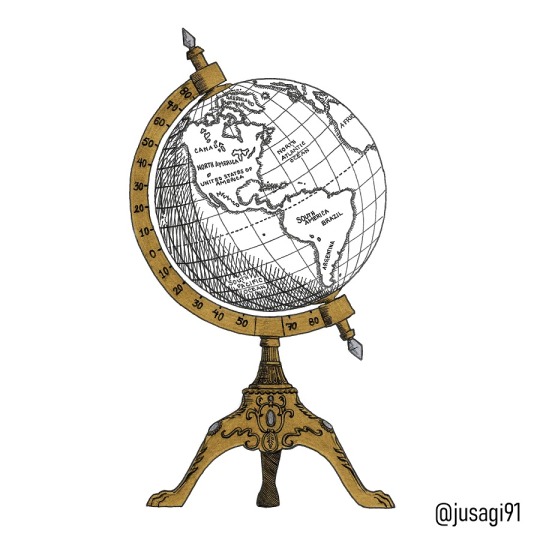
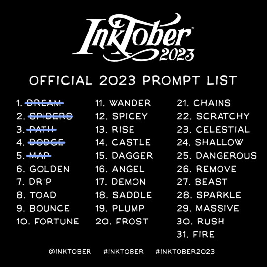
Day 5: MAP 🌎🗺️
#myart#jusagi91#inktober#inktober2023#inktobermap#map#mapa#ink#black and white#golden#silver#sketchbook#globe map#globe#globe earth#globe world#world map#globo terraqueo#antique#traditional art#october#staedler#pen#pentouch#pentouch sakura#inktober2023map#inktoberchallenge#inktober52#inktobermexico
8 notes
·
View notes
Text

0 notes
Text
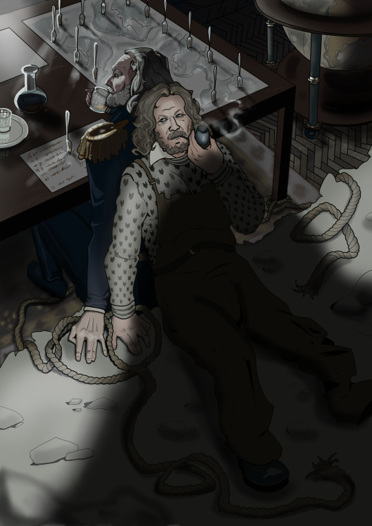
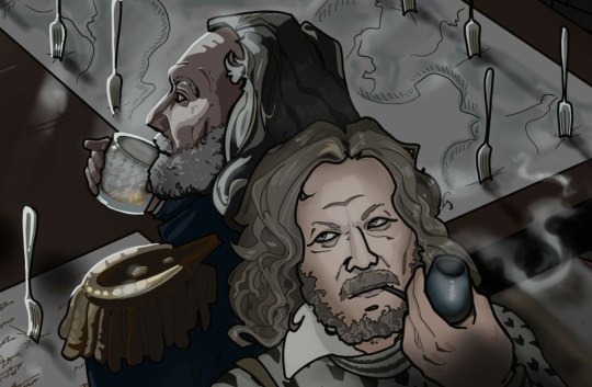
you were the i've-seen-worse that kept me going
Hopelessly late to @the-terror-rarepair-month but here's something for Week 1: (Don't) Wish You Were Here <3
#the terror#sir john ross#thomas blanky#rossblanky (old man yaoi version)#apologies if i've checked the wrong tags on ao3 and it is in fact not a rarepair!#trpm25#wanted to do the terror february flash too but i don't have an ao3 acc#anyway there might be one more john ross related thingie before the end of the month hehe#krita#commissions open#post-credits bonus: mind ross' notes written in blood and blanky's frustrated forks in the map 👉👈#as well as the globe with africa cleft in two like a heart
207 notes
·
View notes
Text

Robinson Crusoe's island located on a globe. Journeys through bookland. v.3. 1922.
Internet Archive
117 notes
·
View notes
Text

Isometric Systems in Isotropic Space. Map Projection: Snail, by Ágnes Dénes, 1974
177 notes
·
View notes

Text

why yes, i am calculating the geographical size of vaugarde for a fic just to be able to tell how long the journey from dormont to bambouche would take on foot in a preteen-friendly speed. why do you ask
if you do ask, look in the tags or uhhh idk. ask me about it? id actually love to yap about it but it's. this is just math. that i'm doing for fun. i'm a linguist this is not my area of expertise but its just interesting i swear
(hey guys i made a whole post about this hello here it is x)
#i calculated this by drafting latitude+latitude marks onto the globe and transferring that to the close up map#counting out the estimate coords of the spots on the map and then comparing the distance on a real world map#in stars and time#isat#aura yammer
61 notes
·
View notes
Text
About the entanglement of "science" and Empire. About how children are encouraged participate in these imperial "scripts".
Was thinking about this recent thing:
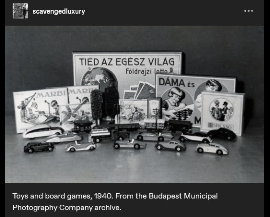
The caption reads: "Toys and board games, 1940." And I think the text on the game-box in the back says something like "the whole world is yours", maybe? (Use of appeals to science/progress in imperial narratives is a thing already well-known, especially for those familiar with Victorian era, Edwardian era, Gilded Age, early twentieth century, etc., in US and Europe.)
And was struck, because I had also recently gone looking through other posts about the often-strange imagery of children's material in late nineteenth- and early twentieth-century US/Europe. And was disturbed/intrigued by this thing:
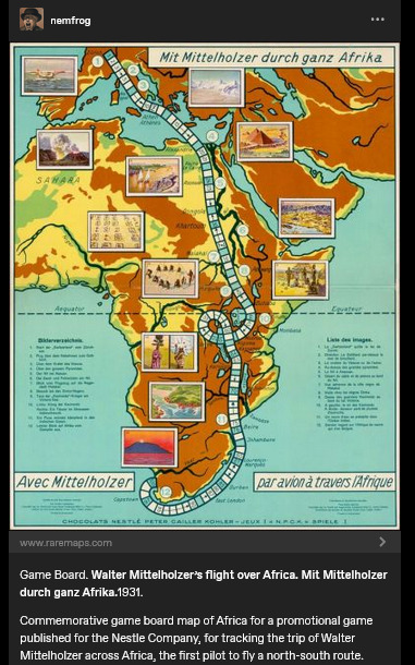
Caption here reads: "Game Board. Walter Mittelholzer's flight over Africa. [...] 1931. Commemorative game board map of Africa for a promotional game published for the N*stle Company, for tracking the trip of Walter Mittelholzer across Africa, the first pilot to fly a north-south route."
Hmm.
I went to learn more about this: Produced in Switzerland. "Africa is for your consumption and pleasure. Brought to you by the N#stle Company!" (See the name-dropping of N#stle at the bottom of the board.) A company which, in the preceding decade, had shifted focus to expand its cacao production (which would be dependent on tropical plantations). Adventure, excitement, knowledge, science, engineering prowess, etc. For kids! (In 1896, Switzerland had hosted a "human zoo" at the Swiss Second National Exhibition in Geneva, where the "Village Noir" exhibit put living people on display; they were over two hundred people from Senegal, who lived in a "mock village" in Geneva's central square.)
Another, from a couple decades earlier, this time English-language.
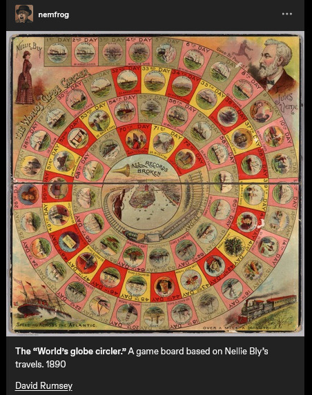
Caption reads: "The "World's globe circler." A game board based on Nellie Bly's travels. 1890." At center, a trumpet, and a proclamation: "ALL RECORDS BROKEN".
Went to find more info: Lithographed game board produced in New York. Images on the board also show Jules Verne; Bly, in real-world travels, was attempting to emulate the journey of the character Phileas Fogg in Verne's Around the World in Eighty Days (1872).
Game produced in the same year that the United States "closed the frontier" and conquered "the Wild West" (the massacre at Wounded Knee happened in December 1890). A couple years later, the US annexed Hawai'i; by decade's end, the US military was in both Cuba and the Philippines. The Scramble for Africa was taking place. At the time, Britain especially already had a culture of "travel writing" or "travel fiction" or whatever we want to call it, wherein domestic residents of the metropole back home could read about travel, tourism, expeditions, adventures, etc. on the peripheries of the Empire. Concurrent with the advent of popular novels, magazines, mass-market print media, etc. Intrepid explorers rescuing Indigenous peoples from their own backwardness. Many tales of exotic allure set in South Asia. Heroic white hunters taking down scary tigers. Elegant Englishwomen sipping tea in the shade of an umbrella, giggling at the elephants, the local customs, the strange sights. Orientalism, tropicality, othering, paternalism, etc.
I'd lately been looking at a lot of work on race/racism in British scientific and pop-sci literature involving natural history or geographical imaginaries. (From scholars like Varun Sharma, Rohan Deb Roy, Ezra Rashkow, Jonathan Saha, Pratik Chakrabarti.) But I'd also lately been looking at Mashid Mayar's work, which I think closely suits this kinda thing with the board games. Some of her publications:
"From Tools to Toys: American Dissected Maps and Geographic Knowledge at the Turn of the Twentieth Century". In: Knowledge Landscapes North America, edited by Kloeckner et al., 2016.
"What on Earth! Slated Globes, School Geography and Imperial Pedagogy". European Journal of American Studies 16, number 3, Summer 2020.
Citizens and Rulers of the World: The American Child and the Cartographic Pedagogies of Empire, 2022.
Discussing her book, Mayar was interviewed by LA Review of Books in 2022. She says:
[Quote.] Growing up at the turn of the 20th century, for many American children, also meant learning to view the world through the lens of "home geography." [...] [T]hey inevitably responded to the transnational whims of an empire that had stretched its dominion across the globe [recent forays into Panama, Cuba, Hawai'i, the Philippines] [...]. [W]hite, well-to-do, literate American children [...] learned how to identify and imagine “homes” on the map of the world. [...] [T]he cognitive maps children developed, to which we have access through the scant archival records they left behind (i.e., geographical puzzles they designed and printed in juvenile periodicals) [...] mixed nativism and the logic of colonization with playful, appropriative scalar confusion, and an intimate, often unquestioned sense of belonging to the global expanse of an empire [...]. Dissected maps - that is, maps mounted on cardboard or wood and then cut into smaller pieces that children were to put back together - are a generative example of the ways imperial pedagogy [...] found its place outside formal education, in children's lives outside the classroom. [...] [W]ell before having been adopted as playthings in the United States, dissected maps had been designed to entertain and teach the children of King George III about the global spatial affairs of the British Empire. […] [J]uvenile periodicals of the time printed child-made geographical puzzles [...]. [I]t was their assumption that "(un)charted," non-American spaces (both inside and outside the national borders) sought legibility as potential homes, [...] and that, if they did not do so, they were bound to recede into ruin/"savagery," meaning that it would become the colonizers' responsibility/burden to "restore" them [...]. [E]mpires learn from and owe to childhood in their attempts at survival and growth over generations [...]. [These] "multigenerational power constellations" [...] survived, by making accessible pedagogical scripts that children of the white and wealthy could learn from and appropriate as times changed [...]. [End quote.] Source: Words of Mashid Mayar, as transcribed in an interviewed conducted and published by M. Buna. "Children's Maps of the American Empire: A Conversation with Mashid Mayar". LA Review of Books. 11 July 2022.
Some other stuff I'd recently put in a to-read list, specifically about European (especially German) geographical imaginaries of globe-as-playground:
The Play World: Toys, Texts, and the Transatlantic German Childhood (Patricia Anne Simpson, 2020) /// "19th-Century Board Game Offers a Tour of the German Colonies" (Sarah Zabrodski, 2016) /// Advertising Empire: Race and Visual Culture in Imperial Germany (David Ciarlo, 2011) /// Learning Empire: Globalization and the German Quest for World Status, 1875-1919 (Erik Grimmer-Solem, 2019) /// “Ruling Africa: Science as Sovereignty in the German Colonial Empire and Its Aftermath” (Andrew Zimmerman. In: German Colonialism in a Global Age, 2014) /// "Exotic Education: Writing Empire for German Boys and Girls, 1884-1914". (Jeffrey Bowersox. In: German Colonialism and National Identity, 2017) /// Raising Germans in the Age of Empire: Youth and Colonial Culture, 1871-1914 (Jeff Bowersox, 2013) /// "[Translation:] (Educating Modernism: A Trade-Specific Portrait of the German Toy Industry in the Developing Mass-Market Society)" (Heike Hoffmann, PhD dissertation, Tubingen, 2000) /// Home and Harem: Nature, Gender, Empire, and the Cultures of Travel (Inderpal Grewal, 1996) /// "'Le rix d'Indochine' at the French Table: Representation of Food, Race and the Vietnamese in a Colonial-Era Board Game" (Elizabeth Collins, 2021) /// "The Beast in a Box: Playing with Empire in Early Nineteenth-Century Britain" (Romita Ray, 2006) /// Playing Oppression: The Legacy of Conquest and Empire in Colonialist Board Games (Mary Flanagan and Mikael Jakobsson, 2023)
#mashid mayar book is useful also the Playing Oppression book is open access online if you want#in her article on slated globes mayar also mentions how european maps by 1890s provoked a sort of replete homogenous filling in of globe#where european metropole thought of itself as having sufficiently mapped the planet by now knit into neat web of interimperial trade#and so european apparent knowledge of globe provided apparently enlightened position of educating or subjugating the masses#whereas US at time was more interested in remapping at their discretion#a thing which relates to what we were talking about in posts earlier today where elizabeth deloughrey describes twentieth century US#and its aerial photographic and satellite perspectives especially of Oceania and Pacific as if it now understood the totality of the planet#ecologies#tidalectics#geographic imaginaries#mashid mayar#indigenous pedagogies#black methodologies#tigers and elephans#victorian and edwardian popular culture#my writing i guess
142 notes
·
View notes
Text
something that’s been bugging me all day: how would you teach perspective drawing in a society that existed entirely within, say, a varied-gravity spaceship? so much of how we understand perspective is based on the existence of the horizon and our relationship to it. what if there’s no horizon? vanishing points as a concept depend on having a ground to be parallel or perpendicular to.
#genuinely i think it’s difficult to fully get your head around how much photography has affected the way we think about art#like. perspective drawing is WEIRD.#putting an image of a 3 dimensional environment onto a flat surface is EXPONENTIALLY more convoluted than flattening a globe into a map#and yet there’s intense debate over the ‘best’ of dozens of world map projections#but we think of photographs as objective fact#and even THEN perspective drawing is usually *still insufficient to simulate photography*#but perspective and distance are still clearly real#things that are further away look smaller#there’s even mathematical consistency to it#but how do you explain how to flatten it#to someone who’s got no idea what ‘down’ means#…i should really be getting work done#mumbling
228 notes
·
View notes
Text
someone needs to respectfully gather a miku from each country and make a miku map 🗺️ of the world; also Earth Miku, just the whole earth is miku, Miku Earth
#miku worldwide#miku international#miku#hatsune miku#vocaloid miku#miku fanart#miku culture#earth miku#miku earth#planet miku#if i could do drawing art i'd do this myself#but i only know silly graphic design 😔#someone draw this#miku map#miku atlas#miku globe#miku 🩵
114 notes
·
View notes
Text

人類 - ベクトル地球 (2016)
#album art#cover art#2010s#人類#evaporated sounds#haylurion#ambient#electronic#vaporwave#map#globe#music
20 notes
·
View notes
Text


Na srebrnym globie / On the Silver Globe Andrzej Zulawski. 1988
Palace Pałac Luboradz, Luboradz 3B, 59-407 Luboradz, Poland See in map
See in imdb
#andrzej zulawski#andrzej żuławski#na srebrnym globie#on the silver globe#palace#luboradz#poland#lower silesia#movie#cinema#film#location#google maps#street view#1988
34 notes
·
View notes
Text


Wishing it was this simple (2025)
#cottagecore#cute#photography#whimsicore#comfy#cottage aesthetic#cottagecharm#cozy#dark aesthetic#fuzzy#globewander#globe#world#world map#dark academia#dark art#dark and moody#dark acedemia#photographers of tumblr#tumblr#artists on tumblr#photographers on tumblr
36 notes
·
View notes
Text

A scrimshawed pocket globe made of whalebone from the late 1700s, showing six continents, whaling grounds in the South Pacific, and an image of Neptune across the Atlantic. Approx. 2 inch diameter.
#reddit#artefactporn#gagator43#scrimshaw#pocket globe#globe#map#whaling#south pacific#neptune#atlantic#1700s#art#unknown artist#whale#south america#north america
26 notes
·
View notes
Text

On top of the world. The magic forest. 1903.
Internet Archive
#map#globe#earth#children's book illustration#whimsy#on top of the world#western hemisphere#nemfrog#1903#early 1900s
235 notes
·
View notes
Text


Frutiger Aero inspired nails by piopionails
#piopionails#transparent by me#frutiger aero#transparent pngs#pngs#nails#nail art#fashion#style#beauty#fish art#techcore#globe#map#fish#apple
92 notes
·
View notes