#ophiolite
Explore tagged Tumblr posts
Visit Tumblr Blog
Explore Tumblr blogs with no restrictions, modern design and the best experience.
Last Seen Tumblr Blogs


Fun Fact
There are dozens of funny blogs to kill time on Tumblr.
Text
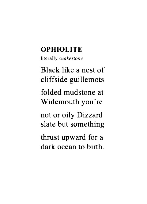
image from here – thank you, victormalonso
51 notes
·
View notes
Text

Ophiolite
32 notes
·
View notes
Text

Ehehehe geology infodump time

Here, my friends, is a piece of the mantle of the earth.
This is peridotite with veins of serpentinite. This rock was born in the middle of the ocean in an oceanic ridge like where you find seafloor hydrothermal vents (aka black smokers) (ophiolite sequence babyyy) like these vv


Then the rock joined a mountain chain in the ocean that got smashed into the west coast of the North American continent and in the ensuing chaos, this rock ended up on the top of a mountain.
When I was on a field trip with my geology class and a couple of geo researchers, my teacher found this rock and the geologists were all geeking out over it. We used the rock in a class project and now that it is the end of the term I got to take this rock home!
#I'm still in intro geology so I'm still learning about this stuff#but this is the story the geologists on the trip deduced about this rock#geology#ophiolite sequence#serpentinized peridotite#it may be kinda ugly but this is the coolest rock I own#siletzia#oh yeah#fun fact: asbestos comes from serpentinite
18 notes
·
View notes
Note
wait no please explain mineral processing!!!
I gasped in delight at the ask, haha. I love mineral processing.
Mineral processing is the theory of economically getting your desired element out of whatever it naturally comes in. So Li out of spodumene, or Cu out of chalcopyrite. It's usually split into hydrometallurgy and pyrometallurgy (liquid chemistry and melting the fuck out of it, respectively), and often taught as hard rock extraction, but you need it for Every Element, really. So you can also focus on extracting phosphates, or nitrates, or uranium! It's chemistry++~
Personally, I know the most about copper extraction and my focus is on hydrometallurgy/geometallurgy, although pyrometallurgy is near to my heart. Copper is coincidentally a really good example of how the two work because it comes as so many natural minerals. (Further explanations under the cut...)
So for copper minerals! You have a whole slew of oxides and sulfides. They occur in different part of your orebodies under different states of oxidation/sulfidation. Take Chrysocolla, Malachite, Chalcocite, and Chalcopyrite. (Cu-silicate)(an oxide), (Cu-carbonate)(an oxide), (Cu-Sulfide), and (Cu-Fe-Sulfide).
Mines usually use hydrometallurgy for oxides by sticking them in a leach heap and pouring sulfuric acid over the whole thing. The acid selectively picks up the Cu ion from silicates and carbonates, leaving the primary tetrahedra alone. The sulfides can work with this chemistry if the mineral's comfort zone is outside of the current conditions (Chalcocite does leach, but usually leaves a Cu ion in the structure as CuS) but minerals like Chalcopyrite are very poor leachers because the outer rim of ions are ripped away, leaving a somewhat-hypothetical "passive layer" of Fe/S that won't react with the acid. So if you have a mine with a lot of Chalcopyrite, you'll be leaving money on the table unless you do something.
So people use pyrometallurgy! Which is what we've been using since the Bronze Age, really. You crush the rock to micrometer grains, use the hydrophobic properties of sulfur to "float" the sulfides in water, then send all of it to the smelter and melt the shit out of it, while adding particular chemicals and minerals to enhance copper recovery while suppressing sulfides you don't want, like sphalerite and galena.
It's REALLY cool. I'm biased of course, but I absolutely love the whole cycle. xD Being in mineral processing also gets you on the backside of geopolitics because you're the only person who understands how to GET things and WHERE to get them and why it's not as simple as pulling Cu out of the ground.
Feel free to ask questions!! I love processing so much, and mining in general, even though I'm only a master's student.
((And NO STUPID QUESTIONS. The mining industry is a goddamn black box DO NOT feel bad if you don't know what stuff means or formulas, or processes. I swear I learn one new word a week. They also have fifty names for everything too because 50 names are always better than 1. 👍)
#Mineral processing is like- the pinnacle of geology in my opinion. I feel so biased saying this! lmfao. I love it though! It's why it#matters if you have Bornite or Chalcopyrite in the ground; or if your ore deposit is in an ophiolite or a porphyry; or if your gold is in a#quartz vein or a fault zone. If your gold is stuck as native in quartz you might not be able to get it out!#To be clear I'm a geologist too. Technically in engineering because that's where this stuff is taught but I identify as Geologist~#mining#mineral processing#geology#I hope I didn't talk too much! I tried to give a good explanation without teaching a class. It's so much info. lol
31 notes
·
View notes
Text
News|North Coast
The remote California road hiding a global geological marvel
Del Norte County's Josephine Ophiolite reveals a cross section of Earth usually buried miles below

Along the Smith River, Josephine Ophiolite, a rare piece of Earth’s upper mantle and oceanic crust, is viewable in the Klamath Mountains.Getty Images/iStockphoto
By Matt LaFever, North Coast Contributing EditorJuly 31, 2025
If you drive far enough north on Highway 101, you’ll eventually wind your way into Del Norte County — the northernmost slice of California’s coast, where towering redwoods meet cold, foggy beaches. At Crescent City, a turnoff takes you inland along Highway 199, following the pristine Smith River toward Oregon. What looks like an ordinary mountain road is anything but. Somewhere along that route, without warning, you pass from redwood forests into a portal to deep time. You are, quite literally, driving through Earth’s mantle.

The Redwood Highway, or U.S. Route 199, follows the pristine Smith River in Northern California toward Oregon.Getty Images/iStockphoto
The rocks here don’t just tell a story. They shape everything you see. Brandon Brown, a geology professor at Cal Poly Humboldt, told SFGATE that it’s the qualities of the stone itself, especially the greenish serpentine found in the Josephine complex, that define the landscape. “We see so many landslides and rock falls,” he said, and the “river is so clear and clean because these rocks don’t pulverize into tiny pieces of clay.” That fragility, Brown said, is why the surrounding “mountains are so jagged and sharp.”

The south fork of the Smith River, the last wild, undammed river in California.Joe Sohm/Visions of America/Universal Images Group via Getty Images
As you drive along the Smith River or hike nearby ridges, you’re seeing rock that was once 15 to 22 miles beneath your feet, Brown explained. “You’re sort of basically driving from the mantle to the ocean floor of the Jurassic as you drive from Hiouchi to the Oregon border.”
Each year, Brown brings his geology students to this stretch of the Josephine Ophiolite to experience it firsthand. “It’s just so many light bulbs” going off, Brown said. Instead of relying on textbook diagrams of tectonic plates “riding around on the Earth,” students find themselves, as Brown puts it, “now standing in the mantle,” or standing on what was the ocean floor from 200 million years ago.

A sweeping view of Castle Lake and Mount Shasta within the Klamath Range in 2024.Mark C Stevens/Getty Images
Brown said researchers from “literally around the world” still come to study the Josephine because of what it reveals about Earth’s progression.And they aren’t the only ones. The exposed mantle here is made of ultramafic rock, a dense iron- and magnesium-rich material formed deep within the Earth. When exposed at the surface, these rocks break down into thin, nutrient-poor soils with unusual mineral balances, which leads to some distinctive flora.
“When I’m taking students out there to look at this, we’re almost for certain going to run into a botany class,” Brown said, “because the types of plants that grow on them is very unique due to their obscure and strange magnesium and calcium ratios.”
The contrast is dramatic, even to the untrained eye. Along certain trails, you move from thick, towering groves into sparse, scrubby forests in just a few steps. “You pass from redwood to giant redwood trees, and you cross the fault. ... Now you’re looking at 100-year-old trees that are like the diameter of my arm,” Brown said. “They’re just sort of struggling, persisting along, using whatever nutrients they can find.”

The Smith River flows through national and state parks near Crescent City, Calif.Samuel Howell/Getty Images/iStockphoto
Today, what lies exposed along the Smith River isn’t just rock. It’s a cross section of Earth’s engine room, preserved with extraordinary clarity. For scientists and students alike, it’s a place where abstract theories become tangible.
“It’s just a magical place,” Brown said.
6 notes
·
View notes
Text

NO DINNER FOR CASCADIA TONIGHT
In a story I've been writing with San Andreas, Cascadia appears as this monstrous unstoppable juggernaut, an officer in Gaia's military with countless volcanoes, tsunamis, and faults as his soldiers.
But it's more fun cartoon-wise if Cascadia is depicted as slowly going insane due to not being able to eat subduct new chunks of the Juan de Fuca plate for hundreds of years. (There actually was a 1000-year gap between Cascadia earthquakes at one point...dude just had to go a millennium without dinner lol). Ophiolites are the chunks of mid-ocean ridges that don't get subducted, and are instead plastered onto the continent. If he couldn't subduct them before, it's doubtful he could now, but he's getting desperate...
In any case it's a moot point because this particular ophiolite rock is a piece of the Farallon-Pacific Ridge, aka San Andreas' dead mom. San Andreas of course does not let him have it, slicing through the ground and offsetting the ophiolite and Cascadia away from each other.
If you look closely, San Andreas' eye shines resemble a right-lateral strike slip focal mechanism, and he has a seismogram trace burning from his eye. He's normally a dork, but Cascadia has a tendency to get him really really mad*.
I should note Cascadia's not a selfish glutton. He cares a lot about his volcanoes, and they depend on the magma he creates using the oceanic crust he subducts. So he's literally eating for 20...or how many volcanoes you count as the Cascade range**.
*When the Cascadia subduction zone ruptures, the San Andreas typically does a few decades later from all the stress the former dumps on it.
** Something something an "an army marches on its stomach"...literally in this case since Cascadia eats by running things over and his mouth is on his underside.
#webcomic#geology#geophysics#san andreas fault#cascadia subudction zone#subduction zone#fault#earthquake#plate tectonics
7 notes
·
View notes
Text
Under the oceans
Have you ever wondered what exactly lies at the bottom of the ocean? Or, well, under the bottom of the ocean.
The oceanic crust is relatively thin, only between 2 and 10 km at most, with a global average of 7 km. Its density is between 2.8 and 3.2 g/cm^3 and it is theorized that it cannot be older than 250 millions of years, as oceanic ridges continuously form new crust, while the earth "reclaims" parts of it through subduction.
What is more interesting to me though, is what is actually inside of it.
The "Ophiolitic Sequence" is a reoccurring series of rock formations that can be consistently found through the oceanic crust. As opposed to its continental counterpart, the oceanic crust is relatively predictable from what is known, and usually the same formations can be found in the same order from surface to mantle.
Keep in mind that all of these formations aren't always found under the oceanic crust, in some areas some of them may be missing.
This is a very idealized rendition of what the ophiolitic sequence might look like:
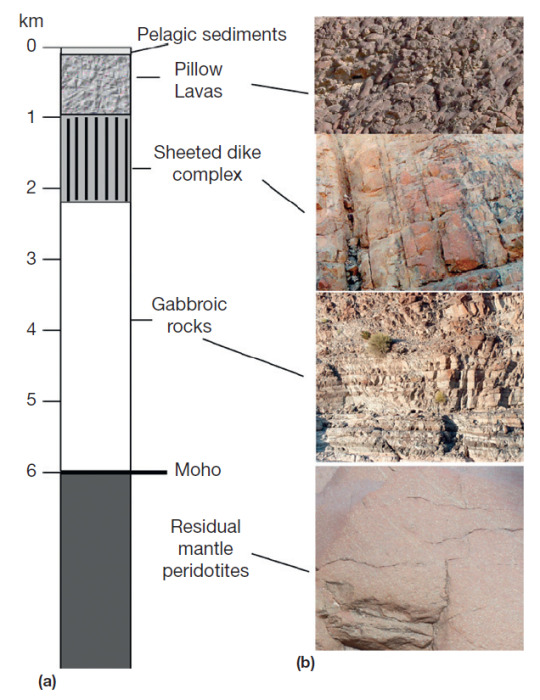
From top to bottom we have:
Pelagic sediments: at the deepest parts of the ocean, this means mostly clay sediments and silicates. Rarely you can find limestone sediments in the ocean, especially at significant depths.
Pillow lavas: the most superficial ignenous formations, formed by lava emerging from the oceanic ridges. They care called this way because when the lava emerges, it comes into contact with water - water applies a hydrostatic pressure that forced the lava to solidify in a rounded shape, similar to the one of a pillow.
Basaltic dykes/dikes: dykes are vertical or semi-vertical magmatic intrusions, these are made of basalt which means they are particularly rich in plagioclase feldspar minerals, specifically rich in calcium.
Gabbroic rocks: gabbro is an intrusive rock, it is pretty much the intrusive counterpart to basalt, as it is also rich in high-Ca plagioclase feldspar minerals.
Moho: "Moho" is not a rock formation, but a geologic and chemical discontinuity that separates crust and mantle, the full name of the discontinuity is "Mohorovičić discontinuity", but most people refer to it as just Moho. It's definied by a significant change in the velocity of seismic waves that pass through it.
Peridotites: the top of the mantle is made up mainly by dunites and peridotites, which are both "ultramaphic rocks", as in rocks that are particularly rich in magnesium and iron. dunites are significantly rich in olivine minerals, while the term "peridotite" is used to refer to ultramaphic rocks that have both olivine and pyroxen minerals in relatively similar ratios. (There is honestly an entire essay that could be written about these rocks alone but maybe in a different post, they are my favorite rocks lol).
I hope this post was informative and interesting to read, if you have questions please don't hesitate sending asks to my inbox!
86 notes
·
View notes
Text
Mineral spotlight on: Smectite♡

Last Thursday, researchers at MIT published findings that suggest this stylish clay mineral plays a significant role in reducing atmospheric CO2.
An ophiolite is a piece of ocean crust that has been moved onto continental crust by tectonic forces. They contain mafic and ultramafic rock (rocks high in magnesium and iron). And they are a suspect consistently on the scene during global cooling.
Previously, scientists had attributed the creation of ice-house climates during the Paleozoic period to the weathering of these ophiolites.
However, geochemical analysis illustrates that cooling happened through the burial of organic carbon, not weathering. This is where smectite (my beloved) comes in.
Turns out, the weathering of mafic rocks creates smectite clays with very high surface areas. Under a microscope, smectite looks like an accordion.

Carbon gets trapped inside these grooves and removed from the atmosphere! That’s another way the tectonic forces of the geosphere influence global climate.
#earthscience review#research scientist#stem academia#science news#news#science#geoscience#geology#geologist#university#college#climate change#planets#stemblr#dark academia
22 notes
·
View notes
Text


assorted diagrams from my marine geology course
descriptions below the cut:
1. convection of heat in the upper mantle
2. example distribution coefficients of elements graphed as functions of liquid magma/original rock concentrations over fraction of partial melting
3. different ophiolite formation mechanisms
4. classification chart of meteorites
5. diagram of how sonar works
6. graph identifying lithospheric rocks by their % mineral composition
7. depth profile of p-wave velocity through ocean lithosphere and its corresponding layers
8. diagram of earths magnetic field and the direction of magnetic field lines in different hemispheres
9. bathymetric profiles of mid-ocean ridges by type of spreading rate
10. ophiolite model of the rock layers of oceanic lithosphere
11. crust of the juan de fuca ridge color-coded by age found from magnetic field polarity reversals preserved via remnant magnetization. bars of the barcode on the left correspond to periods of normal (colored) polarity and reverse (white) polarity
12. degree of partial melting of the mantle during asthenospheric upwelling beneath mid-ocean ridges
14 notes
·
View notes
Text
earlier this year: I want to go to the Applegate area to find Applegate jade (serpentine) ^_^
earlier this week looking up notable ophiolites: ohhh it makes sense that there's cool serpentine in Applegate since it's (on? by?) the Josephine ophiolite
now after impulsively googling "serpentine wetland": I Need To Go To Josephine County Or I Might Die And If I See The Endemic Species There I Might Also Die
1 note
·
View note
Text
gabbro, granite, diorite, volcanic breccia, tuff, pumice, andesite, basalt, carbonatite, trachyandesite, trachybasalt, rhyolite, lamproite, kimberlite, microcline, orthoclase, plagioclase, muscovite, biotite, chlorite, ophiolite, grossular garnet, hessonite, uvaroite, feldspar, sanidine, sunstone, moonstone, labradorite, indigo gabbro, tangerine quartz, strawberry quartz, rutilated quartz, tourmalated quartz, rose quartz, amethyst, carnelian, sardonyx, onyx, picture jasper, obsidian, rainbow obsidian, starburst obsidian, snowflake obsidian, cumengite, torbernite, monazite, dolomite, augite, autunite, hornblende, amphibole, lithium include quartz, amphibole quartz, tourmaline, watermelon tourmaline, schorl, ametrine, citrine, lemon quartz, tiffany stone, charoite, beryl, chrysoberyl, alexandrite, emerald, aquamarine, larimar, bixbite, spinel, limestone, dendritic agate, heliodor, morganite, goshenite, enhydro quartz, shale, mudstone, sandstone, siltstone, shale, claystone, conglomerate, marble, graphite, galena, kyanite, lepidolite, stitchtite, mugglestone, helenite, calcite, blue calcite, crazy lage agate, ellensberg blue, zircon, topaz, mystic topaz, cinnabar, realgar, orpiment, cobalto calcite, mangano calcite, pyrite, pyroxene, jadeite, nephrite, chalcopyrite, clinopyroxene, diamond, herkimer diamond, peridot, olivine, peridotite, glaucophane, blueschist, greenschist, greenstone, schist, phyllite, staurolite, phosphophyllite, gneiss, slate, jet, shungite, desert rose, selenite, fluorite, yellow fluorite, rainbow fluorite, fire opal, fire agate, azurite, malachite, cuprite, pink opal, red jasper, ocean jasper, magnetite, sodalite, lapis lazuli, rutile, silver rutile, bismuth, rhodonite, rhodochrosite, pyrope garnet, sulfur, pegmatite, vesuvianite, manganese vesuvianite, turquoise, stony iron meteorite, carbonaceous meteorite, fossiliferous limestone, serpentine, serpentinite, halite, celestite, ruby, sapphire, yellow sapphire, padparadscha sapphire, corundum, blue lace agate, botswana agate, amphibolite, euclase, kunzite, antarcticite, ice, lawsonite, unakite, smoky quartz, sugilite, mossy agate, lodelite, dunite, angel aura quartz, dalmation jasper, bumblebee jasper, honey calcite, tanzanite, zoisite, danburite, apophyllite, ammolite, pietersite,

547K notes
·
View notes
Photo

100% Genuine Green Serpentine Crystal | Healing Stone from Cornwall, UK | Natural British Mineral | With Certificate
Tap into the grounding energy of nature with this Green Serpentine Healing Crystal, a naturally beautiful specimen from the geologically significant region of Cornwall, UK. Known for its deep green tones and earthy textures, this stone is a prized addition for collectors, crystal healers, and those drawn to the spiritual and geological heritage of Britain.
This piece is carefully selected and photographed, so you will receive the exact specimen shown. A scale cube (1cm squares) is included in all photos for accurate sizing—please refer to the full gallery for measurements.
Geological Information:
Green Serpentine is a group of magnesium-rich silicate minerals, most commonly lizardite, antigorite, or chrysotile. It forms from the alteration of ultramafic rocks through hydrothermal processes and low-grade metamorphism. Cornwall’s Lizard Peninsula is world-famous for its serpentine deposits, which formed during the closure of ancient oceanic crust and are now exposed as part of an ophiolite complex.
Crystal Type:
Species: Serpentine Group (commonly Lizardite or Antigorite)
Variety: Green Serpentine
Formation Environment: Low-grade metamorphic zones in ultramafic rock bodies, especially in ophiolite sequences like those in Cornwall
Metaphysical Properties:
Green Serpentine is believed to be a stone of regeneration, grounding, and connection to Earth energies. It is particularly linked to the Root and Heart Chakras, supporting emotional resilience, energy flow, and inner peace. Many also use it for awakening Kundalini energy and enhancing meditation practices.
Why Buy From Us:
All of our crystals are 100% genuine natural specimens and are supplied with a Certificate of Authenticity. This authentic Green Serpentine from Cornwall is ideal for collectors, crystal enthusiasts, spiritual practitioners, or anyone seeking a meaningful natural treasure.
Order today and bring home a unique piece of Britain’s natural geology with the empowering energy of Green Serpentine.
#Green Serpentine#Cornish Serpentine#Natural Serpentine Crystal#Healing Crystal UK#British Mineral Specimen#Chakra Stone#Root Chakra Crystal#Cornwall Crystal#Grounding Stone#Serpentine Stone UK#Certificate of Authenticity#Genuine Green Crystal#Energy Healing Stone#Collector’s Mineral
0 notes
Note
Can I get a list of names generated from Italian desserts, flowers, gemstones, and high fashion brands? Thanks in advance
That's a mouthful,
Names generated from Italian foods and desserts; Common worldwide flowers and herbs; Gemstones; And high fashion brands.
Aafferso Abeloweite Abitar Aboliolinet Aburoy Acelexanick Aizzillitch Alarlay Alphiotia Alycront Amandondy Anakine Anapaste Andret Anzalcion Aoshati Aostworsale Apotti Appedro Ardknöder Armessece Asicilia Aspolèti Assata Assillasto Avermacripp Azzang Balimil Ballay Balower Bareette Barega Barper Basampia Basquamina Beingel Bellorso Berajlacane Bionde Bluetton Bocothso Boistwoon Bomargal Bomazulta Bombeetta Boneta Borbend Bougaliela Bousis Bousiten Briched Britenza Brokeledaf Bruccary Brucce Buchmer Buckinonc Bulimattio Buttino Cabregianne Cakentiu Calizze Camalazed Cambalest Camillven Campan Campist Canfonbuton Canute Carasapper Carayel Carfel Cargio Cariceter Carldord Carommy Carons Caroseed Caroshingch Castorlan Catate Catelleriòn Catilymels Catorlea Catturne Cellsee Cenned Cenzotte Ceseette Cheski Chient Chimocci Cholloweed Chradgline Cilartano Clatimez Clavet Clowdron Cobsilcio Cochibarve Colitagne Comouarelka Conatelliny Coreseired Coromas Cotlek Cottioli Coured Courelite Crayer Creggs Criacillino Cribiolan Cricciast Crilleir Cruston Cublacoo Curavinee...
Dahlny Darrate Deavia Deberriso Dedleeraff Degints Dellecturge Delnulada Derdaiz Derlosta Destre Diellicone Dildinettin Dintizeed Dontzo Dorese Doureate Dourée Dranda Drocciour Ellette Emellcetta Eulètio Fabran Fardurmen Fasilingia Felled Fermento Feruff Fetwidia Finčić Fiumstriòn Fiuoillia Flacallon Flanckle Flotheed Floweadi Fognetti Forgilk Forroli Fourgherry Frablo Freary Frille Friòniter Frummily Frìton Fulaine Furtinth Fyolaba Gabian Galiacci Gattines Gaullalinsa Gellotiang Gettoassite Gevard Giania Gingualleto Glimiten Glited Glitenbamle Gortnute Gosenti Gotibass Gradayer Granlah Grentoppen Gresord Guttone Hallce Hapetierg Hapine Heascil Heitelle Herrycruite Heweem Higliane Hodonerien Hoesatinto Homeunisher Horitence Hugtuslacce Hunapít Imougia Ingchinaced Inkleite Intarrium Iroleed Iscant Ischee Issille Jaceli Jaffel Jarabaxina Jerint Kevoube Kinothric Ladino Lamenso Lamilla Landiss Landuic Lanfena Lanqua Latano Lelotte Lemino Liadne Lianio Litergariso Lognolver Lomardi Loquastan Loverrits Lumagnonla Luolarice Luxoth Magirodro Mailkanzel Maleat Maleiton Manflo Mantisil Marbel Marbeno Marchanta Marciat Mardia Marier Marite Marostiffer Martinote Mataimac Matimilk Micking Mielli Milatill Milaïs Mingharma Miscalis Misilowea Modayed Mommeed Moncasuan Moquil Morreed Muccio Nakeldo Naspip Neorena Niaman Niarawar Niteds Niterven Nonitele Nutting Obeedleds Oberilks Ochite Oilisti Oingerricy Oliolo Ollsenia Ophiolite Osemilacchi Pacciner Palineorper Palleppen Pannetacto Panovar Pantuctia Panyle Paravasite Parbersla Pargenium Pariòn Parmen Paroka Parrypiss Pataio Patopste Pausanoup Pazzelled Peamia Peatic Perseezi Petteltella Pettioleno Phicheasìn Pigliang Pipepadidi Polinne Polish Poprela Pouccate Prabairg Preatorred Pretion Pricen Pringmis Pulacioldi Pummarate Purile Purzipst Pusiging Pussamed Pâtivers Rabbissicny Randerilty Ravaurcon Reddhry Rellharro Rellsko Rhermão Rhoubellsey Richeas Riersarìto Rigalatz Riggiush Rilabent Rinece Rinikads Rintaccang Robsweekked Rodiff Ronith Ronsid Rosaler Rumusta Rustia Rutedis Saiand Salawsled Samseenitto Sandouga Sapise Satenceseno Satzesh Scherice Seedatiner Seenza Semony Serada Serrize Seyworts Sfibbissca Sfiulang Shaketagli Sinetperb Sitenel Skiterfē Smohurrui Smoilyte Socciopkni Sonnea Soottuli Spig's Spitsail Spolakno Spolinti Spollotte Sponsic Sprosphidi Stayle Steibam Stelbed Stellick Stongura Strambarg Striffoxx Stronistex Suggandarc Sunting Swerse Tacouster Tagnelvarat Tallia Tangia Tanniarr Taskine Tayena Teggskyan Thewilskyan Tiennerb Toiterro Tombacé Toolle Tophilds Tritaced Truffed Tuffena Tuforayak Tuling Tunheenatba Tunhodd' Turhevino Turisli Turmed Tweite Tylemina Typliozzup Umagno Unleimocla Valeflo Valtagaredo Vandería Vastmaisù Vellet Venflatte Vetrèmerry Vikardince Wataien Weetticke Whecolea Whervidisù Womenri Worcia Yanits Yarfogna Yeddunciorn Youcciono Zeesey Ziantinta Ziback Zuccìa
0 notes
Text
Resource Wars: The Hidden Economic Interests Behind Conflicts in Manipur and Chin State
The ongoing conflicts in Manipur, India, and Chin State, Myanmar, are often seen through the lens of ethnic strife and political instability. However, beneath the surface lies a crucial but less-discussed factor: resource extraction and geopolitical competition. Both regions are rich in minerals, hydrocarbons, and other valuable natural resources, making them prime targets for economic exploitation. This article explores how these conflicts may be linked to strategic interests in resource extraction and regional control.
Manipur is home to chromite, limestone, and hydrocarbon reserves. In recent years, the Indian central government has taken steps to grant mining permits to private firms, particularly in the ophiolite belt, which contains large deposits of chromite (used in stainless steel production). Other valuable minerals, including limestone, have also attracted industrial interest.
Additionally, oil and natural gas exploration in Manipur has been on the rise, with various companies conducting surveys to assess potential reserves. The presence of these resources has made Manipur a significant area for economic expansion—raising questions about whether ongoing conflicts serve as a distraction while resources are secured for large-scale extraction.
Chin State, located across the border in Myanmar, is also rich in minerals, hydrocarbons, and rare earth elements. While Myanmar’s military government has largely controlled resource extraction, foreign corporations—particularly from China and India—have shown increasing interest in energy and mineral projects in the region.
Both Manipur and Chin State have experienced prolonged ethnic conflicts, leading to heavy militarization. In Manipur, ethnic tensions between Meitei and Kuki-Zo communities have resulted in large-scale violence and displacement. In Chin State, ongoing clashes between ethnic militias and Myanmar’s military junta have caused significant instability.
Militarization serves multiple purposes:
Control over resource-rich areas: Heavy troop deployment ensures that valuable mineral zones remain accessible for extraction.
Displacement of local communities: By forcing indigenous populations to flee, resistance to large-scale mining and energy projects is weakened.
Suppression of local activism: Indigenous groups opposing resource extraction face repression under the guise of maintaining security.
Conflicts often result in mass displacement, which can create opportunities for corporations and governments to gain access to lands that were previously occupied by indigenous groups.
In Manipur, ethnic violence has led to thousands being displaced, making it easier for the government to push forward with mining and oil extraction projects.
In Chin State, instability has forced many to flee to India, reducing resistance to Chinese and Myanmar government-backed projects in the region.
India’s Act East Policy aims to strengthen economic ties with Southeast Asia, making Manipur and Chin State crucial geographical zones.
Infrastructure projects like the Kaladan Multi-Modal Transit Transport Project, connecting India to Myanmar’s Sittwe Port, show India’s commitment to using this corridor for trade and resource access.
Ensuring political and military control over Manipur and securing influence in Chin State helps India counter China’s growing presence in Myanmar’s resource sector.
China has invested heavily in mining, energy, and infrastructure projects in Myanmar, particularly in Kachin, Shan, and Chin states. By securing control over natural resources and trade routes, China strengthens its economic dominance in the region.
China’s Belt and Road Initiative (BRI) includes projects in Myanmar that give it access to critical minerals and energy supplies.
India, on the other hand, is seeking to counterbalance this influence by developing its own economic corridors through Myanmar and Northeast India.
Are the Conflicts a Cover for Resource Extraction?
While ethnic tensions are genuine and deeply rooted, it is difficult to ignore the economic incentives behind these conflicts. The escalation of violence in resource-rich areas raises questions about whether instability is being exploited to facilitate large-scale mining, oil extraction, and infrastructure projects.
In both Manipur and Chin State, conflicts have created conditions where governments and corporations can expand their economic influence with less local resistance. The geopolitical competition between India and China further complicates the situation, as both nations seek to control vital trade routes and resource deposits in the region.
As the situation unfolds, it is crucial to examine who benefits from these conflicts—whether it is the local populations or external economic and political powers. Without addressing these underlying economic interests, peace in these regions may remain elusive.
#ManipurConflict#ResourceExtraction#Geopolitics#EthnicConflict#NaturalResources#ManipurCrisis#ChinStateConflict#NortheastIndia#MyanmarConflict#ActEastPolicy#ResourceWars#GeopoliticalTensions#MiningInIndia#RareEarthMetals#EnergyPolitics#DisplacementCrisis#EnvironmentalImpact#HumanRightsViolations#Militarization#ConflictEconomy
1 note
·
View note
Text
True! Lol. I went digging just to see how likely it was the original author was referring to alum because citation holes are my favorite thing to do at 7am instead of getting out of bed, and found... nothing. The English ref is paywalled and I can't find the German one. Put in a request at the library.
Mindat does have the locality though, (with the original German citation), and according to multiple sources, it absolutely isn't any deposit that can form table salt.
However, I want to cut the translators slack, because alum had a lot of names. The unfortunate reality is that physically, it's "shitty white rock" and there are a lot of "shitty white rocks" that got lumped together. I can understand then if the Renaissance German word for alum was 'salt' because it dissolved, and "salt" is the correct official translation - because that would only be incorrect to someone looking for alum, or even knows about the existence of alum as a commodity.
The biggest question in my mind now, is I have a book on my shelf I haven't read, which is very popular and I think got a few non-fiction awards, called Salt.
And if that author didn't do due diligence, I can think of several ways that book is going to go tits up and I will deconstruct it on my dash wholesale for free.
I love being a geologist because it makes history mistranslation errors glaringly obvious.

Absolutely fucking not. These mines were Cu, Ag, and Zn; I googled. You're not producing fucking salt from that.
Alum though.
Yes, you would produce alum from alunite from that deposit. Salt is probably the literal German translation because alum is a salt; but the economic/English implications are incorrect.
#VMS deposit for those who are curious. Probably with an overlapping epithermal since they also mined Ag and that's odd#to find in large quantities in a volcanic massive sulfide. They form on the seafloor and then get uplifted as ophiolites.#They were some of the oldest copper mines because they're small localized high-grade deposits. They also have lead and zinc too.#I'm staring at SALT on my shelf now though and thinking in horror of all the times I was told the African civilizations got rich selling#gold and salt. This isn't FAIR. I work in COPPER. I am out of my ELEMENT. I'm tired of reading papers and being dragged into a#centuries-deep chemical disentanglement.#ptxt#geology#... out of my element. lol. pun now intended.
16 notes
·
View notes
Text
Argille rosse in Val Ceno


Affioramento di argille rosse in una bella zona di calanchi presso Serravalle in Val Ceno, salendo sulle colline il paesaggio all’orizzonte presenta tutto un sussegguirsi di versanti calanchivi dai colori caldi, in lontananza, a chiudere la parata, svetta la mole ofiolitica del monte Prinzera. In questa zona è presente anche un caratteristico “fungo” d’argilla, non comune nelle nostre zone.
Outcrop of red clay rocks in a beautiful area of gullies near Serravalle in Val Ceno. Climbing up the hills the landscape on the horizon presents a succession of warm-colored gully slopes, in the distance, to close the parade, stands the ophiolitic mass of Mount Prinzera . In this area there is also a characteristic clay “mushroom”, not common in parmesan areas.
0 notes