#snake software on bear hardware
Explore tagged Tumblr posts
Visit Tumblr Blog
Explore Tumblr blogs with no restrictions, modern design and the best experience.
Last Seen Tumblr Blogs


Fun Fact
Tumblr has been providing a Korean-language service since 2013.
Text
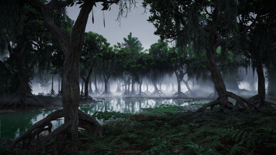
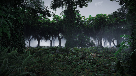
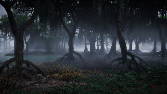
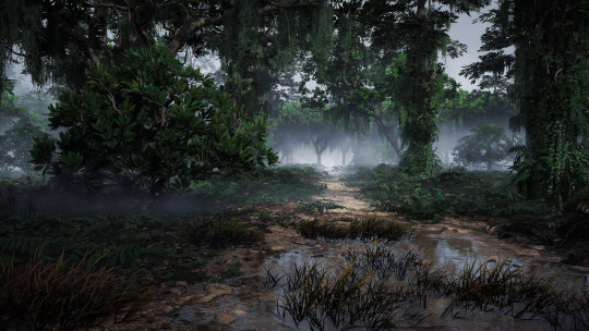
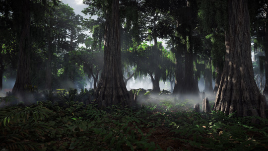

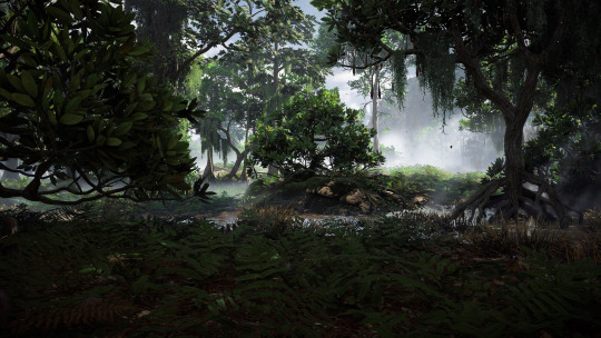

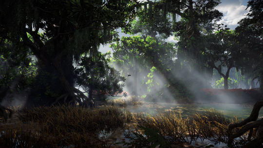
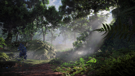
Fog
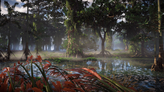
#horizon forbidden west#hfw#hfw photomode#thornmarsh tuesdays are back!#(at least for this week)#i haven't actually been spending much time here#too many fireclaws#and not enough sac webbing#also got spotted by the fireclaw at the huge container/cart site#because i peeked out of the grass for half a second#and then wasn't entirely concealed by it due to a slope#at least i think that's what happened#i took a video of the thing#and still don't quite understand#because at no point of this was the fireclaw visible to me#until it just loomed over me like 'i see you'#it was an apex one too#maybe heph just got them infrared vision#snake software on bear hardware#who knows at this point
24 notes
·
View notes
Text
Imagine...
... building some kind of machinery/project with Kid.

He builds hardware and you build software. He assembles parts into a functioning machine and you instruct said machine. There's a special bond that develops between the two of you because of the activity, connects you in a more intimate way than how his superglue attaches two slabs of metals together, which you don't think other people would ever understand. It's by no means an easy job, and it takes you weeks - months - until your efforts bear fruit, and the journey there is painful.
Most of the time Kid fails. And fails. And fails some more. Parts aren't locking together as expected, tools are getting misplaced, measurements are done wrongly, components are missing, the things he ordered don't arrive on time. He scowls, yells in anger, throws a wrench or two, and breaks some windows. In these times, it's up to you to make sure he doesn't accidentally murder someone, and you find that it's so much easier to deal with him than cold, soulless, unforgiving lines of codes - with a promise of food, impromptu movie night, sex and a lazy morning, he's all set and ready to continue from wherever it is he left off, this time with a cooler head and renewed vigor.
Most of the time you too fail. And fail. And fail some more. Encounter logical errors in codes, forget a semicolon, miss a capitalization on variable names, forget to charge your laptop and lose a file you've been working on for almost two hours, nearly throw your water bottle across the room because you should have used snake case instead of camel case. You pull on your hairs, down your fifth coffee for the day, and consider laying on the ground to contemplate life. In these times, Kid either kicks a wall with you or holds you close as you cry, surprisingly gentle as he mumbles about stupid machines making your lives harder than it's supposed to be and insists on getting into a bath together because you both need it, badly. You're back up and running again the next day, determined and freshly rested.
And when you succeed, when you can visibly see what you've built doing what it's supposed to be doing, see what you've managed to accomplish? When Kid laughs out loud and throws you into the air, hair greasy, tank top drenched in sweat and oil and grime?
All worth it.

A/N: Wow this got super self-indulgent real fast I'm sorry slkdfjlsdf where my fellow software devs at?
114 notes
·
View notes
Text
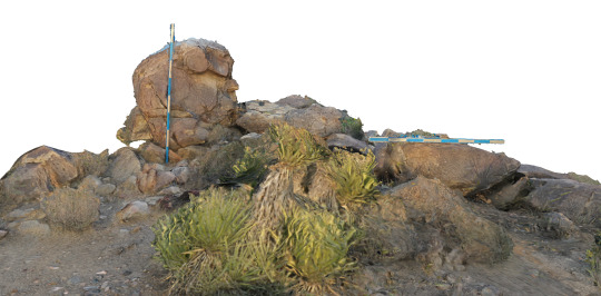
Failures in Photogrammetry
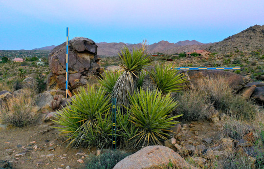
I had the chance to try out my home made photogrammetry calibration system in Joshua Tree last week. With temperatures in triple digits throughout the day, the only reasonable time for this type of activity is early in the morning when the Mojave is also at its most beautiful and wildlife are at their most active. I was surrounded by quail and lizards (no snakes) while setting up and plumbing/leveling the posts a little before dawn and a coyote loped by a few yards away, seemingly indifferent to my presence.
I have long suspected that photogrammetry would supply the key to my practical investigation of the conjunction of data and images following on the theoretical and historical research I did on this subject for Technologies of Vision. Although I have done small-scale experiments in the past with a hardware-based system (Occipital Structure Sensor) that captured infrared depth information to an iPad along with photographic textures, the Joshua Tree environment was orders of magnitude larger and more complex. In addition, my intended processing platform is the entirely software-based Metashape by Agisoft (previously PhotoScan), which generates all depth information from the photographs themselves.
Note: if you have somehow stumbled on this post and are hoping to learn the correct way to use Metashape, please look elsewhere. The internet is full of people -- many of whom don’t really know what they’re doing -- offering authoritative advice on how to use this particular piece of software and I don’t want to add myself to the list. While it’s true that my eventual goal is to gain proficiency with various photogrammetry workflows, I’m currently deriving at least equal pleasure from my near total inability to execute any part of this process as intended. Even the measuring sticks in the above image are of my own conception and may not serve any useful purpose whatsoever.
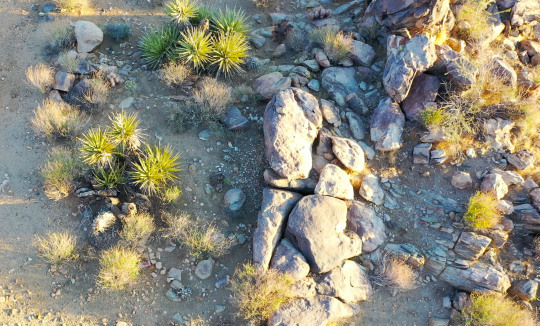
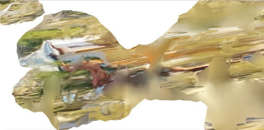
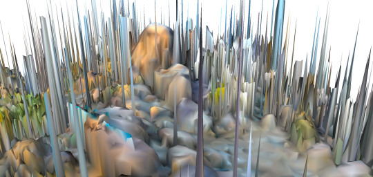
I captured this segment of landscape three separate times, all using a DJI Mavic 2 Pro, but the drone was only in flight for one of the three capture sessions, partly because of unpredictable winds, but also because of not wanting to be reported on by the neighbors. The Joshua Tree Highlands area has declared itself a no-fly zone out of respect for the wildlife, so when I did put the drone up, I flew a grid pattern that was low and slow, capturing video rather than still images to maximize efficiency. As a side note, Metashape is able to import video directly, from which it extracts individual frames like the one above, but something went wrong at the photo alignment stage, and these images -- which should have generated my most comprehensive spatial mapping -- instead produced a faux-landscape that was more exquisitely distorted than any of the other processes I tried.
The thumbnail array below comes from one of my terrestrial capture sessions, the first of which, in my exuberance, consisted of well over 500 images. When this image set took 30+ hours to generate a dense point cloud, I re-photographed the entire area at what I hoped would be a more reasonable total of around 70 images. Even when not in flight, the Mavic generates metadata for each image, including GPS coordinates and information about elevation, camera angle, focal length, etc. Metashape uses this data to help spatialize the images in a 3D environment, creating a visual effect that bears a distinct resemblance to the Field-Works series created -- I have no doubt through a much more laborious process -- by the Japanese media artist Masaki Fujihata beginning in the early 2000s.

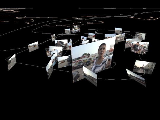
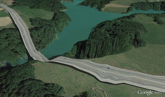
When I wrote about Masaki’s work for TechnoVision, I offered Field-Works (above) as a good object that celebrated the gaps and imperfections in spatialized image systems, in contrast with the totalizing impulse and literal aspiration to world-domination represented by Google Earth. With this practice-based research, then -- my own “Field-Works” -- I remain equally driven by the desire to succeed at capturing a photorealistic landscape, with dimensional data accurate enough to inform an architectural plan, and a secret hope -- even an expectation -- that the result will instead turn out to be an interesting failure -- more like Clement Valla’s dazzling collection Postcards from Google Earth (below), where algorithmically generated photographic textures ooze and stretch in a failed attempt to conceal irregularities in the landscape.
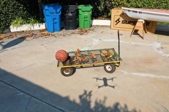
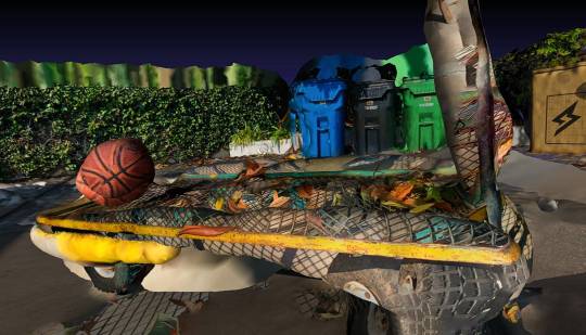
In fact, my first experiment with transforming drone images into dimensional data resulted in just such an outcome. This scene from the back yard (where proximity to LAX also dictates a no-fly zone) grew increasingly interesting with each stage of distortion from image to point cloud to mesh to textured model. The drone never went higher than about 12 feet on two circular passes of about 10 images each and the model was deliberately selected to confound the software. The mesh platform of the wagon, covered with leaves that changed position when blown by the rotors of the Mavic confused the software enough to yield a kind of molten surface reminiscent of Valla, an effect that I have not been able to reproduce since.
This first attempt was created using a free, open source Mac-compatible program called Regard 3D. Although I now have access to PCs with decent graphics processing capability through the VR lab at UCLA, I preferred to stay in the Mac environment to avoid multiple trips across town. In fact, the majority of this post was written while one photogrammetry program or another was rendering models, meshes or depth maps in the background. Although the results from Regard 3D were more than gratifying, I went ahead and purchased an educational license for Metashape and then immediately upgraded to the Pro version when I realized all the features that were withheld from the standard version. Metashape has the advantage of robust documentation -- going back to its days as PhotoScan -- and in-application help features as well as a very active community forum that seems relatively welcoming to people who don’t know what they’re doing.
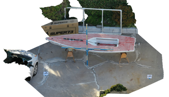
For my second backyard test, I chose slightly more conventional (solid) surfaces and included some reference markers -- 8′ measuring sticks and Agisoft Ground Control Points (GCPs -- seen in lower right and left corners of the image above) to see if these would help with calibration for the mapping in Joshua Tree. Metashape handled the process effortlessly, resulting in a near-photorealistic 3D model. The measuring sticks allowed me to confirm the scale and size of objects in the final model, but the GCPs could not have functioned as intended because I didn’t manually enter their GPS coordinates. Instead, the software seems to have relied on GPS data from the Mavic and I’m not sure my handheld GPS unit would have been any more accurate at locating the GCPs anyway. In fact, when I got to Joshua Tree, although I dutifully printed out and took a bunch of GCP markers like the one below with me, I forgot to use them and didn’t miss having them when reconstructing the landscape.

Although images like this, which are designed to be read by non-human eyes, have been in public circulation for decades -- QR codes, bar codes, etc. -- they continue to fascinate me as fulcrum-objects located at the intersection of data and images. When Metashape “sees” these patterns in an imported image, it ties them to a system of spatial coordinates used to verify the lat/long data captured by the drone. When used correctly, the visual/human register takes precedence over the data systems of machines and satellites. Although unintentional, my failure to use the GCPs may have been a gesture of unconscious resistance to these systems’ fetishization of Cartesian precision.
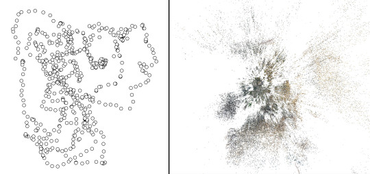
After 36 hours of processing my initial set of 570 images (mapped by location above on the left), Metashape produced a “dense point cloud” (right) representing all vertices where the software identified the same visual feature in more than one image. Although the area I intended to map was only about 5000 square feet, the software found vertices extending in all directions -- literally for miles -- across the Joshua basin. A bounding box (below) is used to exclude outlying vertices from the point cloud and to define a limited volume for the next stages of modeling.

The point cloud can also be viewed using the color information associated with each vertex point (below). This begins to resemble a low-resolution photographic representation of the landscape, which also reveals the areas (resembling patches of snow on the ground) where image-data is missing. Likewise, although the bounding box has removed most outlying information from the distant hillsides, many vertices have still been incorrectly mapped, appearing as sparse clouds against the white background. Metashape has the ability to scan and remove these artifacts automatically by calculating the confidence with which each vertex has been rendered, but they can also be deleted manually. Still not fully trusting the software, I removed the majority of these orphan points by hand, which also allowed me to exclude areas of the model that I knew would not be needed even though they might have a high confidence value. Under other circumstances, of course, I am totally opposed to “cleaning” data to minimize artifacts and imperfections, but the 30+ hours of processing required to render the initial cloud had left me scarred and impatient.

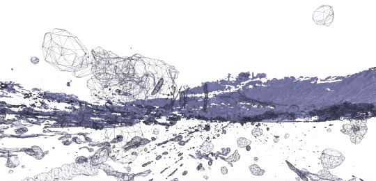
The next step is to create a wireframe mesh that defines the surfaces of the model, transforming the point cloud into a dimensional web of triangles. With tens of millions of potential vertices to incorporate, the software may be set to limit the mesh to a maximum number of triangular faces, which in turn, determines the final precision of the model.

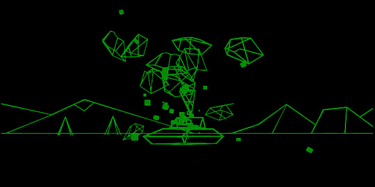
At this point, the model can be rotated in space and a strong sense of the overall contours of the landscape is readily apparent. The aesthetics of the wireframe are also exquisite in their own right -- admittedly perhaps as a result of my fascination with the economical graphic environment of the early 80s Atari game Battlezone (below) -- and there is always a part of me that wants to export and use the wireframe as-is. In fact, I assume this is possible -- though I haven’t yet tried it -- and I look forward to figuring out how to create 3D flythroughs and/or navigable environments with these landscapes rendered as an untextured mesh.
The final stage in creating the model is for Metashape to generate textures based on the original photographs that are mapped onto the mesh surfaces. At this stage, gaps in the point cloud are filled in algorithmically, eliminating the snow effect on the ground. By limiting the size of the model and deleting as many artifacts as possible, the final texturing was relatively quick, even at high resolution, and the resulting model is exportable in a variety of 3D formats.
Metashape also offers the ability to generate digital elevation maps (DEMs), which register relative heights of the landscape signified by color or shape. I’m reasonably certain that the DEM image below is the result of some egregious error, but it remains among my favorite outputs of this exercise.
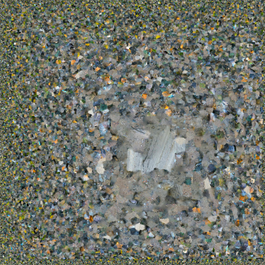
The final image included here is the single frame used by the photogrammetry software for texture mapping. Although it gives the appearance at first glance of being an aerial photograph of a strangely featureless landscape, this file is actually an indexed palette of all the color and texture combinations present on all surfaces of the 3D model. If photogrammetry constitutes the key technology operating in the interstices between data and images, these files are arguably the most liminal of all its components. Neither mimetic nor computational, they provide visual information (“pixel-data”) that is necessary to the perceptual phenomenon of photorealism, while denying the pleasures of recognition. In a literal sense, this single image contains every color and texture that may be seen in the 3D model, rendered here as an abstraction fully legible only to the eyes of the machine.
0 notes
Text
Der Vorgänger des Commodore 64 bekommt jetzt auch einen Nachbau mit zig legendären Spielen der 1980er Jahre. Das bietet der TheVIC20.
Die Macher des TheC64 Mini und des TheC64 bringen mit dem TheVIC20 einen weiteren Nachbau eines Commodore-Heimrechners in den Handel. Bereits im Oktober soll die Replik des C64-Vorläufers erscheinen.
Das bietet der TheVIC20
Hersteller Retro Games bringt den ursprünglich 1981 veröffentlichten Vic-20 noch einmal in den Handel. Bis 1984 wurde der Heimcomputer hergestellt, stolze 2,5 Millionen Mal wurde dieser bis 1985 verkauft. Der C64 knüpfte mit verbesserter Hardware an die Erfolge des Vic-20 an.
Das “Remake” besitzt die originalen Ausmaße des Computer-Urgesteins, im Inneren steckt allerdings zeitgemäße Technik. Das heißt: Ihr könnt das Gerät problemlos über HDMI an euren Fernseher anschließen. Nostalgiker schalten via Software einen CRT-Filter ein. Die Tastatur ist voll funktionsfähig, ihr könnt also auch regulär im Basic des TheVIC20 programmieren. Das Vic-20-Basic ist vorinstalliert.
Der Joystick. (Foto: Retro Games)
Mit schöner Verpackung. (Foto: Retro Games)
Die Tastatur ist voll funktionsfähig. (Foto: Retro Games)
Das Auswahl-Menü. (Foto: Retro Games)
Hier wählt ihr passende Spielmodi aus. (Foto: Retro Games)
Aber: TheVIC20 emuliert den Vic-20, genauso übrigens den Commodore 64. Denn ihr könnt auch auf das C64-Basic sowie vorinstallierte Spiele vom Vic-20 (28) und C64 (36) zugreifen. Zusätzlich lassen sich eigene Spiele via USB-Stick nutzen. An drei weiteren USB-Ports schließt ihr weitere Joysticks und Gamepads an. Für Multiplayer-Action ist also gesorgt.
Zocken wie damals
Interessant: Ein an einen Competition Pro erinnernder Joystick liegt dem Lieferumfang bei. Der kommt bei den zahlreichen Games zum Einsatz, genau genommen diese:
Vic-20-Spiele des TheVIC20
Abductor
Andes Attack
Arcadia
Bewitched
Blitzkrieg
Brainstorm
Catcha Snatcha
Connect 4
Encounter
Frantic
Frog Chase
Gridrunner
Harvester
Headbanger’s Heaven
Hell Gate
Laser Zone
Martians
Matrix
Mega Vault
Metagalactic Llamas Battle at the Edge of Time
Psychedelia
Snake
Starquest
Subspace Striker
Tank Battle
Traxx
Wacky Waiters
Zor
Commodore 64 auf dem TheVIC20
Alleykat
Bear Bovver
Boulder Dash
California Games
Chips Challenge
Cyberdyne Warrior
Cybernoid II
Destroyer
Firelord
Galencia Mini
Gribbly’s Day Out
Heartland
Impossible Mission
IO
Iridis Alpha
Jumpman
Mega Apocalypse
Nebulus
Netherworld
Paradroid
Pitstop II
Planet of Death
Robin of the Wood
Speedball 2
Spindizzy
Street Sports Baseball
Street Sports Basketball
Summer Games II
Super Cycle
Sword of Fargoal
Temple of Apshai Trilogy
The Arc of Yesod
Uridium
Winter Games
World Games
Zynaps
Wer braucht den TheVIC20?
Zugegeben: Wenn ihr bereits einen TheC64 besitzt, stellt sich schon die Frage, wieso ihr euch noch einen TheVIC20 zulegen solltet. Vermutlich richtet sich der Computer an Retro-Liebhaber, die damals mit dem VIC-20 aufgewachsen sind. Qualitativ besser dürften dennoch die C64-Spiele sein, mich persönlich reizen die VIC-20-Games eher in Maßen.
youtube
Seht ihr das anders: Für rund 120 Euro soll das gute Stück verkauft werden. Eine Vorbestellung ist derzeit nur für Briten auf Amazon UK möglich. Ob es der TheVIC20 nach Deutschland schafft? Das wird sich zeigen. Die Frage, die ich mir derzeit viel dringender stelle ist: Wann kommt endlich ein TheAmiga500 oder ein TheAmiga1200?
Der Vorgänger des legendären Commodore 64 bekommt eine Neuauflage. Das bietet der TheVIC20. #thevic20 Der Vorgänger des Commodore 64 bekommt jetzt auch einen Nachbau mit zig legendären Spielen der 1980er Jahre.
0 notes
Text
This Story Behind team Will Haunt You For life!
Ten Innovative Ways You Can Do With group.
The evidence offered by Kotter & Heskett absolutely leads one in conclusion that improving company culture can positively informational social influence (Elettartameletmod.info) business income, supply costs as well as take-home pay. In their next video game, the first semi-final of the competitors, they dealt with Germany team who were tipped by several to be the next European champs. Even big firms, such as Walmart (tm), do group building excercizes every day. Each participant of the team must feel their everyday existence is essential for the company's health. A person who is clear with his/her own demands as well as capacities and also who chooses with the among a group, is definitely a much more dedicated team member than a person who is unclear of him-/ herself and also who is just" a member of the group. And also one inquiry is going to control the discussion, equally as it has because the No. 2 total pick in the 2017 NFL draft. Amy is a PhD trainee at the College of Edinburgh, as well as joined the W3C Group in 2016 whilst a seeing pupil at MIT. This publication will certainly aid you to find the team work task that is ideal for your business. My concepts presented below suggest that long standing corporate culture can be altered with team structure events. The underlying approach as well as the strategies ought to be targeted at developing greater understanding and also skills in order to help everyone to be at their best independently and also as a group. Beardwell & Holder (2001) highlights High quality Circles (QCs) as one of such strategies where group of 6-10 staff members in meeting held regular or fortnightly recognizes troubles from their own location via information collection methods and also statistical strategies.
Five Various Ways To Do group.
There are a myriad of various reasons people decide to homeschool their youngsters: there is the economic advantage of staying clear of high independent school charges; there is the ease of scheduling education around other family tasks and so on
Seven Mind Numbing Information About group.
Challenge examining the interactions hardware and software prior to every group conference, as well as make certain to have a backup system in situation of system failing. Use the minimum quantity of employee as well as aim to structure the group as if a leader is present (preferably representing concentrating on the Partnership) sustained by an individual concentrating on the Job components of the arrangement. If you are a fan of football, you can purchase t shirts of your group so you can reveal your assistance to every person. These 2 need to go to contrary ends of an area and even in different spaces - much sufficient away that they can not communicate at all. You can take pleasure in the manifold advantages of outsourcing by working with an entire online group to work for you- and all under roof covering and also from the workplace of the exact same outsourcing supplier. Problems with your employee might not always be their mistake - make certain to check your team's framework and whether they have the direction and sources needed to meet your assumptions. . And also, if they trust the process, they'll provide important ideas and point of views on team concerns. As soon as the group is perfectly accustomed with how the rest of the seminar will certainly go, there are numerous fun activities that could occur. In some business, it would be tough to imagine trying to kick a huge vanity off a group or label someone a 'snake' and ask to leave. The techniques relating to the soccer formations, styles of play, football support, the speed of play and free kicks are a few of the most vital elements that can offer the high school football gamers a gaining edge over the other team. One final point on this is - for the leader to make sure that what obtains lastly specified as a shared ambition or objective for the group is something that will certainly evoke pride in its members on effective achievement Apart from being S.M.A.R.T, the objective has to motivate. Perhaps the greatest resource of monetary benefit from Group Citadel 2 originates from the uncommon Uncommon hats. When interacting with employees administrators need to bear in mind to (2) hear exactly what is being said, (3) be prompt in actions, and also, (4) offer exact details. I have actually tried to show my grandchildren the outcomes of team tidying up in the evening and also establishing the table for dinner. The group does not lose power sidetracked by problems that they could not solve however on attaining the objectives of the team.
0 notes