
Last Seen Blogs

danbroadcaster
Untitled

sweatyparadiseunknown-blog
Sweatyparadiseunknown

namraniilife
silly girlblogging

ughpaul
UGHPAUL

elirogue
ELirogue
Photo
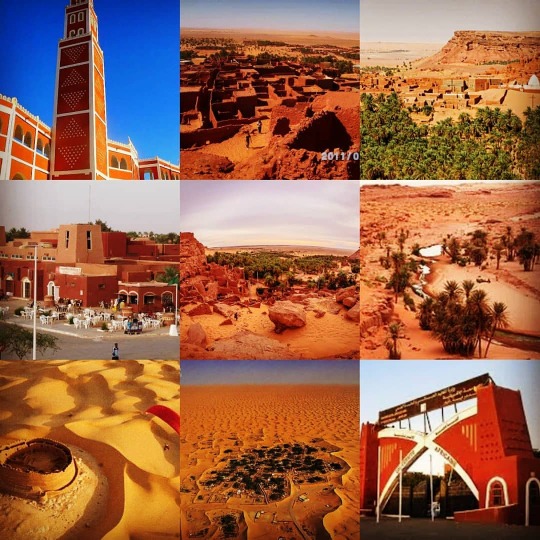
The state of#Adrar_is_a_desert region as part of the Great African desert, located between latitudes 26 and 30 degrees north and between longitudes 04 west to 01 east, which made it a natural extension of the Tansroft depression to the north and the Tadmite plateau to the south. The geographical pattern of Adrar state is characterized by flat terrain, hammadas, plateaus and races interspersed with many salty sabkhas and green oases linking over a large underground water basin, making it a first-class peasant state despite its distinction of desert and semi-desert climates. Adrar state And its borders from the south, Mali In the cities of Baji al-Mukhtar and Temaween. Area: 443 782 km2 population: 402,197 inhabitants (2008 year) State capital: Adrar State code: 01 Telephone numbering: 49 The state of Adrar is located in the southwestern part of Algeria, 1,500 kilometers from Algiers. It is bordered to the north by the Wilayat of El Bayadh and to the east by the states of Bechar and Tindouf and to the south by the Republics of Mali and Mauritania. Its area is estimated at: 471,137 square kilometers and has a population of more than 452,726 people (2013). It consists of four historical regions: the Qorara district, Tidiklit Tuat and Tensroft. The state of Adrar is a desert region as part of the Great African Sahara, located between latitudes 26 and 30 degrees north and between longitudes 04 west to 01 east, which made it a natural extension of the Tansroft depression to the north and the Tadmite plateau to the south, and the geographical pattern of the Adrar Hammadas, plateaus and veins interspersed with many salty sabkhas and green oases linking a large underground water basin, which made it a first-class agricultural mandate despite its distinction of desert and semi-desert climates. Historical background of Adrar: Adrar is a modern word that means the mountain in barbarism. It was launched as the name of the capital of the state today, then the word was circulated, and it became known as the university name for the three provinces of the state (Tuwat - Qawarara and Tidikelt). . The Roman historian Herodotus (ca. 5 BC) (في Adrar - Borj Baji Mokhtar) https://www.instagram.com/p/B-rG77UnmZn/?igshid=1n5mtnbufcw95
3 notes
·
View notes
Photo

الحلقة 3- #ولاية_أدرار _01 #Adrare ولايــة أدرار منطقــة صحراوية كجــزء من الصحراء الإفريقية الكبرى تقع بين خطي عرض 26 و 30 درجــة شمالا و بـين خطـي طول 04 غــربا إلى 01 شــرقا مما جعــلها تشكــل امتدادا طبيعيا لمنخـفض تانزروفت بإتجاه الشمال ولهضبة تادمايت في اتجاه الجنوب . و يتميز النمط الجغرافي لولاية أدرار بالتضاريس السهلية و الحمادات و الهضاب و العروق التي تتـخللها العــديد من السبخات المالحة و الواحات الخضراء الرابطة فوق حوض مائي باطني كبير مما جعلها ولاية فلاحية من الدرجة الأولى رغم تميزها بالمناخين الصحراوي و الشبه الصحراوي . وحدودها من الجنوب بمالي بمدينتي برج باجي المختار و تيمياوين. المساحة: 443782 كم2 عدد السكان: 402197 نسمة (سنة 2008) عاصمة الولاية: مدينة أدرار رمز الولاية: 01 الترقيم الهاتفي: 49 تقع ولاية أدرار في الجنوب الغربي للجزائر على بعد 1500 كلم من الجزائر العاصمة تحدها من الشمال ولاية البيض و من الشرق ولايتي بشار و تندوف و من الجنوب جمهــوريتي مــالي و مــوريتانيا تـقـدر مساحتها بـ : 471137 كلم مــربع ويبلغ عــدد سكانها أزيــد من 452726 نسمــة (2013) تتكــون من أربع أقـاليم تاريخية منطقة قورارة تيديكلت توات و تنزروفت . ولايــة أدرار منطقــة صحراوية كجــزء من الصحراء الإفريقية الكبرى تقع بين خطي عرض 26 و 30 درجــة شمالا و بـين خطـي طول 04 غــربا إلى 01 شــرقا مما جعــلها تشكــل امتدادا طبيعيا لمنخـفض تانزروفت بإتجاه الشمال ولهضبة تادمايت في اتجاه الجنوب، ويتميز النمط الجغرافي لولاية أدرار بالتضاريس السهلية و الحمادات و الهضاب و العروق التي تتـخللها العــديد من السبخات المالحة و الواحات الخضراء الرابطة فوق حوض مائي باطني كبيرمما جعلها ولاية فلاحية من الدرجة الأولى رغم تميزها بالمناخين الصحراوي و الشبه الصحراوي . نبذة تاريخية عن ولاية أدرار: أدرار كلمة حديثة تعنى الجبل بالبربرية أطلقت كإسم لعاصمة الولاية حاليا ثم عمم اللفظ و أصبح يطلـق إسما جامعا لأقاليم الولاية الثلاثة ( توات – قورارة و تديكلت ) ، و تعتبر مدينة تمنطيط العاصمة الأولى للولاية لتميزها العلمي و الديني لتنتقل إلى تيمي مع نهاية القرن السابع عشر ميلادي . يروى المؤرخ الروماني هيرودوت (ق.5.ق.م) أن منطقة أدرار كانت عـبارة عـن واحــات مــن الــنخيل تتخللها قرى على ضفاف الأنهار و الأودية و البحيرات المائية سكنتها قـبائل الجيتـول وهـم أقـدم سكـان الصحراء التي ساهمت مع يوغرطا ملك نوميديا في هزم الرومان . ثم تحدث إبن خلدون عن مواطن قبائل البربر و العرب بأرض الصـ (في مدينة أدرار) https://www.instagram.com/p/B-rD3EIH-m8/?igshid=14hmam57i4ht1
0 notes


Photo

الحلقة: 3- #ولاية_أدرار ولاية أدرار هي ولاية حدودية تقع في الجنوب الغربي للجزائر. هي الولاية رقم 01 في تصنيف الولايات حسب التنظيم الإداري الجزائري. لها حدود مع كل ... ولاية منذ: 1974 (في Adrar Province) https://www.instagram.com/p/B-VMRSQA72P/?igshid=bsng79mqy50q
1 note
·
View note


