
Interaction Design Student // Ulster University, Belfast
Don't wanna be here? Send us removal request.
Statistics
We looked inside some of the posts by aaron-finnegan and here's what we found interesting.
Average Info
Notes Per Post
0
Likes Per Post
0
Reblog Per Post
0
Reply Per Post
0
Time Between Posts
16 hours
Number of Posts By Type
Text
13
Photo
1
Video
3
Last Seen Tumblr Blogs


Fun Fact
Tumblr posted its first advertisements in May 2012 and subsequently earned $13M in revenue.
Text
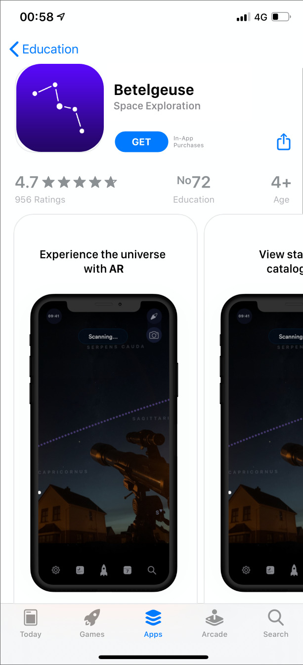
App and Final Year Overview
Approaching the end of the year, I wish I had more time to complete my app. Given the current circumstances, our deadlines have been moved forward, forcing me to cut some features short, and apply my efforts elsewhere. Overall, I am happy with the progress made on Betelgeuse to date, offering some great features.
Given the rapid change in deadlines, and working with what I have currently done to date, I did my best to tidy up as much as possible, however I plan on continuing my work on the app beyond this date to reach its finished stage. I also hadn't the chance to complete my promotional website as much as I had liked however it is live and I plan on focusing on this next before returning to my app designs.
It’s difficult to believe that my final year has come to an end. Across my time at university on Interactive Multimedia Design and Interaction Design, I have had so much fun, received help and guidance from some of the best lectures I could have, and met some incredibly talented people along the way. Such an enjoyable experience, albeit stressful at times, and although I am nervous but also excited for my future ahead.
To everyone who I have met over the the last few years, I owe a massive thank you. All being said and done, here are a final view links to my prototype and walkthrough for Betelgeuse in its current state.
Final Links
Twitter
Instagram
Prototype
Betelgeuse App
Promotional Website
App Walkthrough
0 notes
Photo

Finishing up my prototype app, linking artboards together
0 notes
Text
Understanding Magnification

For many stargazers, understanding magnification is a learning process and a difficult task. With Betelgeuse, I want to make this easier for users. The image above shows the difference in appearance of Jupiter under the same magnification with different weather conditions.
To tackle the problem dealt with by many stargazers, I have included an object essentials area on my app, dedicating tailored content and recommendations for users. The following screenshot shows a user being recommended the best telescope for viewing Venus, based on their location and average weather conditions.

0 notes
Text
Commencing Launch Strategy
Focusing on the marketing aspect of a product is very important. For my launch strategy design, I came across a sotware called Rotato

I used Rotato to generate mock up iPhone templates to showcase my app. Rotato gives full control over a 3D modelled device, allowing a render to be generated from any angle. Here are some example of renders on a clay model I created:


I edited and added text to these images, showcasing features for Betelgeuse such as the example below, displaying the dark sky map page.

0 notes
Text
Creating Constellations in Illustrator
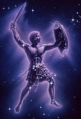
Constellations are formed of bright stars which appear close to each other on the sky, but are really far apart in space. The shapes you see all depend on your point of view. Many societies saw patterns among the stars with gods and goddesses or stories from their culture. Most of the constellations with which we are familiar come from ancient Greece. But other civilizations created their own patterns in the sky based on stories and people that were important to them. The stories below provide an overview of myths associated with the constellations identified by early civilizations around the world.
Replicating one of the most iconic constellations - Orion, I created a vector shape of the constellation to use as a starting point and to establish a style for my own version of these constellations in Adobe Illustrator

0 notes
Video
tumblr
Over the course of my prototyping period I have made several design changes to both the layout and colour scheme of my app.
Upon further research, I stumbled upon a website called colors.com, a site that can be used to assess a colour scheme, providing feedback as to whether of not it adheres to accessibility guidelines.
Other changes made also include:
- Adding requirements for fields to be filled in during the boarding process of Betelgeuse. This adheres to Baymard Form Field Usability which I have did research on by reading this article
https://baymard.com/blog/avoid-multi-column-forms
This article also influenced changes made to other aspects such as navigation,

Assessing my navigation bar, I would like to include a pop out menu to make it more clear for beginners what these icons actually represent. Perhaps a slide over feature - showing the name of the icon when a user clicks on it may be feasible, for now I have a basic onboarding screen to show what these are as a tutorial for beginners.
0 notes
Text
We are live!
I have officially created social media pages and a webpage for Betelgeuse. These platforms will be used to promote the app and spread awareness about Betelgeuse, showcasing its features and what it has to offer.
Marketing is just as essential in launching a product as development and research. This document will highlight the various options to promote awareness around Betelgeuse and provide an insight into the app before launch. Identifying an issue in the current marketplace is essential to the development of a solution.
Social Media Links:
Website: https://betelgeuseapp.co.uk
Twitter: @_betelgeuseapp
Instagram: @_betelgeuseapp
0 notes
Text
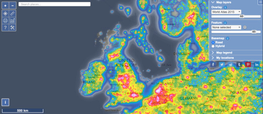
Creating a Light Pollution Map
From my own experience in using light pollution maps, I’ve always found them visually interesting. It’s quite surreal to see how much ground area is impacted by light pollution, most of which comes from artificial light.
In places such as Africa and Australia, were human life is sparse, there are areas of complete darkness. If you stumbled across a very flat area you can sit on the ground and see stars horizon to horizon in a huge cobwebbed dome. It sounds incredible.
Focusing a little bit more closer to home, I created my own mock-up light pollution map based on Northern Ireland. Using a screenshot from Google Maps, I identified the major hotspots for light such as Belfast, Lisburn, Portrush, Armagh and Newry, where light pollution is at its peak.
I assigned a colour for each level (matching the amount of levels on the Bortle scale) to show areas of light, filling in rural areas and countrysides.

0 notes
Text
Creating my own Night Sky in Photoshop
I created by own version of a star filled night sky in photoshop, giving a better illusion to use as a background for my sky map. I have documented the following steps to show how I achieved this method:
1. I started by creating a basic black rectangle. This serves as the background for the image.

2. Next, I added noise to the background, setting the amount to 80%, Gaussian to Distribution and applying as monochromatic.
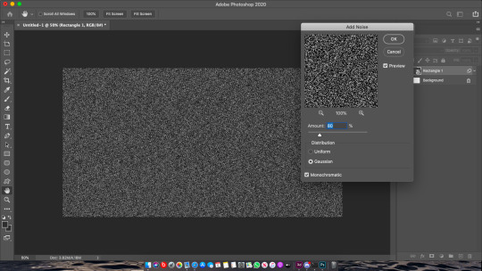
3. By experimenting and altering the adjustment levels, I was able to achieve a result that resembled a star filled night sky.

4. Duplicating the layer a few times and altering the rotation
0 notes
Text
Capturing the Night Sky
Many star-gazing apps use plugins or APIs that are based on pre-existing catalogs of stars. The Bright Star Catalog has about 9000 stars down to magnitude 6, as faint as most people can see in a dark sky without optical aid. The Hipparcos catalog has about 100k stars down to magnitude 9 or 10.

The Hipparcos catalog shown above
0 notes
Text
Finding ‘Space’ the Marketplace
Following the analysis of the existing astronomical app market evaluation, recurrent themes emerged that could be described as problematic or unwelcome to the consumer.
1. Limted Use
Focusing on a highly unique feature, such as virtual stargazing, provides little motivation to return a user base for extended use. This applies in particular to applications which do not see a clear shift in the material. The exception to this evaluation was NASA, whose articles and content would also provide an opportunity to check in and alter.
2. Lack of Visual Clarity
An over-saturation in the use of graphics and overlays results in a cluttered knowledge mess. For example, the obsession with placing screens above the background images with stars is prevalent in many astronomical apps. The resulting screens falter with the typography in contrast and legibility.
3. Communication
With the information needed to describe celestial bodies, apps are struggling tremendously with the presentation of said information. Applications drown in ambiguity, in conjunction with visual over saturation. A simplified approach will help relieve some of the burden that information volume presents.
0 notes
Video
tumblr
Advancing further in my designs - I have created a page hosting a list of information. This animation demonstrates my idea better, and how this feature will be included in Betelgeuse.
Below, users can view information on the planet, its characteristics, and a guide on how to view it in their area. The guide will include aspects such as which telescope is best to use, dark spots in the users area, as well as magnification steps, and how to identify the best weather conditions for viewing Jupiter.
0 notes
Video
tumblr
Experimenting further with animated effects in Adobe XD. Most stargazing apps offer the ability for users to interact and view 3D models of planets and stars - I wanted to try offer something new with a modern design. These fluid animations look great. Models can be minimised, and resized - allowing for users to interact and view a planets surface, while also keeping information on the same page, and allowing it to be displayed in a way that isn't overbearing or cramped.
0 notes
Text
Measuring Light and Displaying Information
When designing a dark sky feature for Betelgeuse, I was faced with the challenge of working how out to present light at different strengths and measuring light pollution in different areas. While I was researching light pollution maps, and how this information is portrayed, I stumbled upon a rating system known as the “Bortle Scale”.
What is the Bortle Scale?
The Bortle Scale, a nine-level rating system that measures sky quality by providing observable standards. John E. Bortle, a retired fire chief and amateur astronomer, devised the rating system in 2001 as a means to help amateur astronomers evaluate the darkness of an observation site and compare sites. The scale ranges from one, an excellent dark-sky site, to nine, an inner-city sky, and specifies observable criteria for each class.
How have I included this in my app?
Taking inspiration from my research, and John E. Bortle’s rating scale, I developed a solution for Betelgeuse in which users can see artificial light that is colour coded. The colours are listed from Levels 1 through 9, representing the Bortle scale. Using complimentary colours makes this visually appealing, and is easy to learn and understand.
As I also learnt from my research, stargazing experiences are often better later in the night than earlier in the evenings. I have also added a section that shows the current darkness of the skies - but also shows a user when their skies in their area will be at peak darkness.

0 notes
Text
Existing light pollution maps shows us that dark skies are rare.
What causes Light Pollution?
Light pollution is caused by using outdoor lights when and where they are not necessary. Poorly designed residential, commercial, and industrial outdoor lights also contribute significantly to light pollution.
Unshielded light fixtures emit more than 50% of their light skyward or sideways. In many instances, only 40% of the light emitted actually illuminates the ground.
It is estimated that nearly 30% of outdoor lighting is wasted due to this poor design. In the United States alone, wasted lighting accounts for 1.7 million tons of carbon dioxide and $2.2 billion in wasted electricity each year.
0 notes
Text
Clear Skies!
Nothing affects our ability to view the night sky more than the weather. Unless the sky conditions are favourable, hands-on astronomy is impossible, so the ability to recognise a potentially good opportunity for viewing or imaging in advance is very useful indeed.
Astronomers and star-gazers often wish each other good luck with the phrase “Clear Skies”
Viewing conditions refer to the steadiness of the atmosphere – twinkling stars may look beautiful to the naked eye but they are a sure sign of poor seeing.
Identifying the Problem for Stargazers
An unsteady atmosphere means detail will be blurred as celestial objects appear to shimmer and pulsate, which can have a particularly bad effect on Solar System objects.
The cause of this is the Earth giving up some of the heat it has absorbed during the day as it tries to reach thermal equilibrium with the cooling atmosphere. The convection currents generated by this process mean that light is slowed down by varying amounts as it passes through different currents.
In other words, the ‘refractive index’ of layers of air in the atmosphere differs, causing the stars to shimmer.
Seeing is always worse earlier in the evening than later.
So, how can you forecast the likely sky conditions for your next astronomy session?
Television and radio weather forecasts tend to cover large regions of the country and are aimed at the general public, so their idea of a ‘clear sky’ is not necessarily the same as stargazers.
Proposing a Solution
What’s needed is an even more localised forecast, such as those on weather-related websites, or smartphone apps
Betelgeuse will include a dark sky map, allowing users to zoom in on their local area to get information, from simple cloud forecasts with temperature, wind speed, pressure and likely rain patterns to satellite images.
0 notes
Text
Creating realistic renditions of planets
Creating a planet render in Blender could be achieved with a few basic steps. Creating a UV sphere, smoothing it out by increasing the segments to 64, rings to 32 and applying smoothing surface modifier, an image can be wrapped around the sphere creating amazing results.
By adding texture co-ordinates, a more 3D effect can be applied to the terrain of the sphere, giving the illusion of a mountainous landscape on the planet surface. I attempted this however it proved to be more difficult to create natural looking surfaces on the surface as if being viewed from a distance in space. This gave me the idea of including a premium option in the app to view a more detailed, close up of planet surfaces although for now, I was able to achieve a realistic planet effect by wrapping images of planet surfaces widely available from NASA/ESA and setting to spherical.

Flat planet surface image shown above
1. Creating UV Sphere

2. Adding Segments and Rings

3. Adding Subdivision Surface

4. Smoothing Out Surface

5. Setting Light Mode to Sun and positioning

6. Pre-Rendering

7. A view with image wrap

UIGDJSD
0 notes