
Statistics
We looked inside some of the posts by ardensarchitecture and here's what we found interesting.
Average Info
Notes Per Post
19
Likes Per Post
19
Reblog Per Post
0
Reply Per Post
0
Time Between Posts
3 days
Number of Posts By Type
Text
11
Photo
1
Last Seen Tumblr Blogs


Fun Fact
If you dial 1-866-584-6757, you can leave an audio post for your followers.
Text
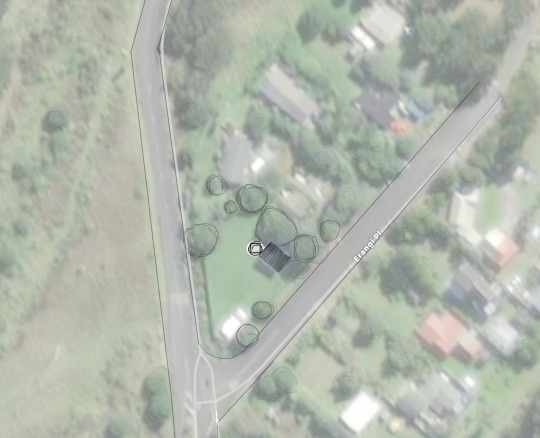
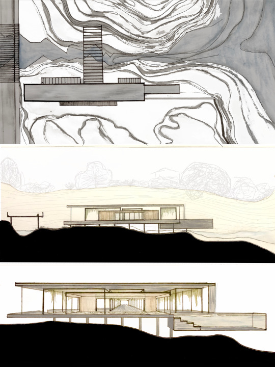
|OVER/ABOUT| Tower Design, 2 Erangi Place. #3
1:100 1 roof plan
1:100 1 floor plan
1:100 2 sections
1:100 1 elevation
1 summative overlay drawing or collage
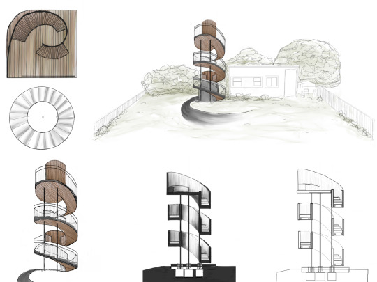
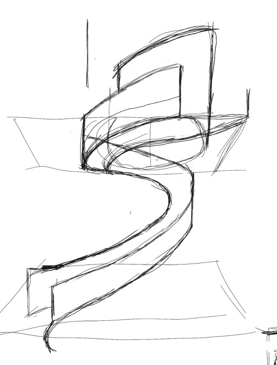
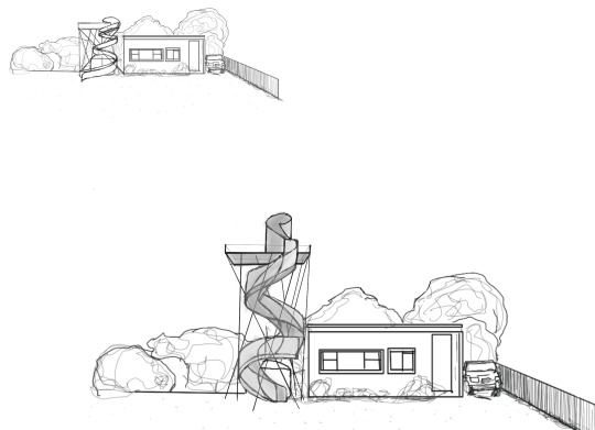
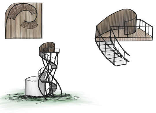
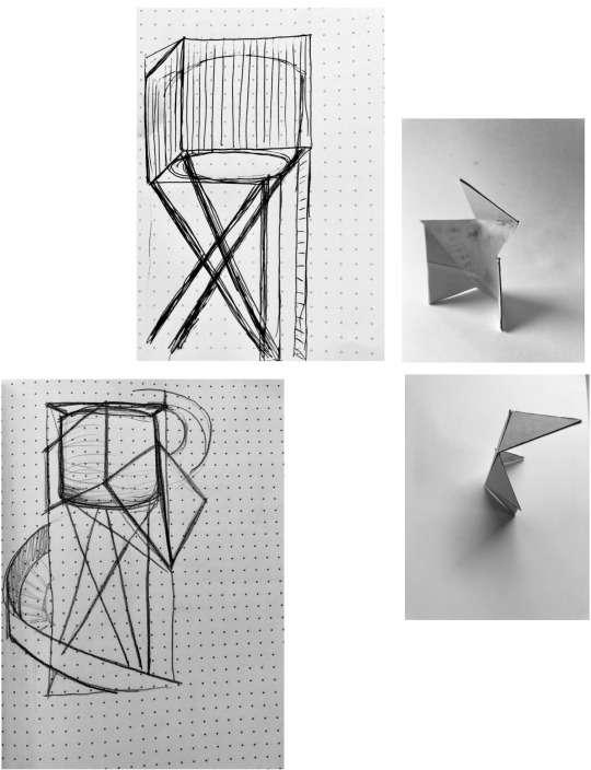
The tower I have designed has a 3m diameter, with the upper platform being 5m above the ground. It is predominately comprised of the dramatic galvanised steel staircase giving you the changing views of the floodplain and the bush, before nestling right at the top of the trees. I decided to clad the underside of the galvanised steel staircase in a natural timber cladding. This was to have the reflectivity of the staircase to be lower, and for it to blend into the natural setting further. The wind breaking turret at the top was designed to allow you to enjoy the view no matter the wind direction. The circular design was modelled from the pattern of an unfurling Fern frond, thus creating the organic forms. I also situated the tower, to wrap around the water tank, as personally I felt that it took away from the character of the Bach significantly, thus with the new architecture from around it, detract from the plastic bulbous form.
1 note
·
View note
Text
|OVER/ABOUT| Tower design, 2 Erangi Place. #2.
Conceptually, what happens to that genotype when you immerse it in the very specific environmental conditions of your design ecology, and particularly, given the work you have done, the site and your sense of it. Through the design process, might the genotype gradually differentiate in response to those conditions, to become a highly specific response to site. Might your tower become a phenotype particular to this place?
Sketch plans: What do I do inside? What goes in there? What does it feel like? Project yourself into, or ‘inhabit’ the project through the plan. Is that what I want? Push it around, make it do what you want it to.
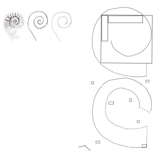
Sections: show overall dimensions. Show in outline the location of any existing elements that are close to the tower.


Materialised elevation.

2 notes
·
View notes
Text
|OVER/ABOUT| Tower design, 2 Erangi Place. #1
Contextual section: 15 minutes: North West to South East, from O’Neills Bay, through the headland (‘mountain’), across the Waitakere River, through the site and up to Lake Wainamu. Your section cut line will have to bend in plan to run through all these. Your drawing might be a single line. If we were to print it, it might unfold across a number of A5 sheets taped together. Indicate the landmarks and the site.

Bad weather sketch: 5 minutes: Draw the experience of standing on the roof of the existing bach, in August, at 5pm, in a 30 knot (strong) westerly wind, as the clouds roll in, just as it starts to rain. Forcing yourself to draw this experiential stuff is as important to the process as the measurable information a surveyor provides.

Activities list: 5 minutes: Make a separate written list all the activities (programme) that people might do on the site.
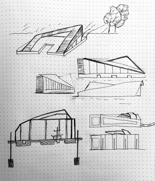
Creating the tower: 20 minute exercise: Sketch options for your tower quickly in 3 dimensions. Do as many as you can. Decide which one to test. Questions for designing: What is the experience of ‘over’ that a tower might enable on this site?,What spatial relationships does the form establish with the buildings and other elements on or near the site? What do those relationships enable? What do you do around there?
Constraints: The building should have no plan dimension over 3.0m. The fixed part of the building is to be no higher than 5.0m above ground level (otherwise It’ll need a resource consent). So ... does part of it move? If so, then how and to what effect / experience?. The site is in a very high wind zone. The site is located on a flood plain (a sandy, river delta). If you’re going to break the rules make sure you have a really good idea to warrant the risk.
Collage: Draw your chosen option as an overlay over the photo. Only deal with the basic form, location, scale, proportion of your tower.
Precedents:
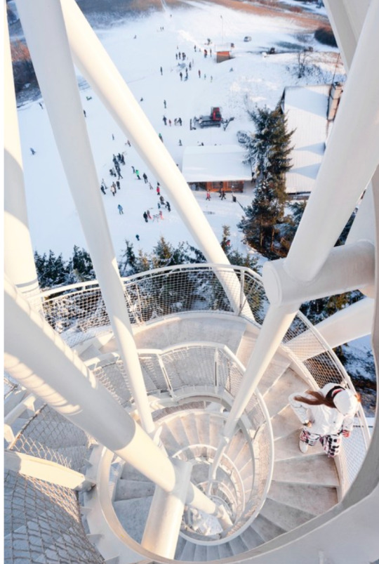
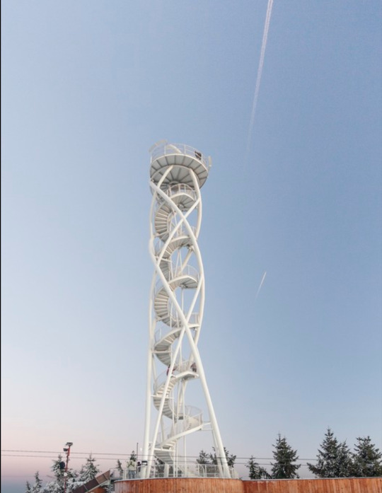
https://www.archdaily.com/804684/fajtuv-observation-tower-studio-acht
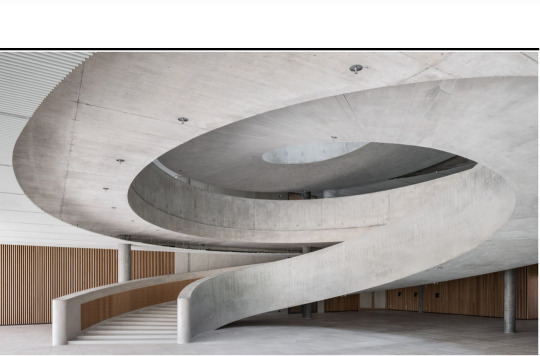
https://www.dezeen.com/2019/05/31/hapimag-headquarters-hildebrand-concrete-spiral-staircase-office/

https://www.dezeen.com/2015/02/05/intertwining-staircases-spiral-wedding-chapel-hiroshi-nakamura-japan/
2 notes
·
View notes
Text
|OVER/UNDER| Architectural Form. Public pools for Waiake. #2
I was tasked to create an architectural design that accompanies the narratives that had been displayed in the Over and Under exercises.
The connections I choose to be my conceptual brief was the movement and journey of water through Waiake as a suburb. In Māori culture, many tribes directly or indirectly consider water as the source or foundation of all life and is the essence of all life, akin to the blood of Papatuanuuku. This is reflected in traditions which speak of te taha wairua, often translated as ‘the spiritual plane (of existence)’. Wai is important throughout all life events, birth, life and survival and death. As well this I choose to tie by building to be a place of ritual, to give my building some sense of purpose. There’s a very strong community around Waiake. Many people you see every day at the same time walking their dogs, exercising, socialising (not currently, obviously) and swimming (all year round). This idea of our daily rituals having great importance over our lives, I tried to embody into the pools, it is a space where we can all have some peace and quiet, or a swim or escape a large downpour in Aucklands fickle weather.
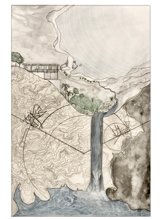
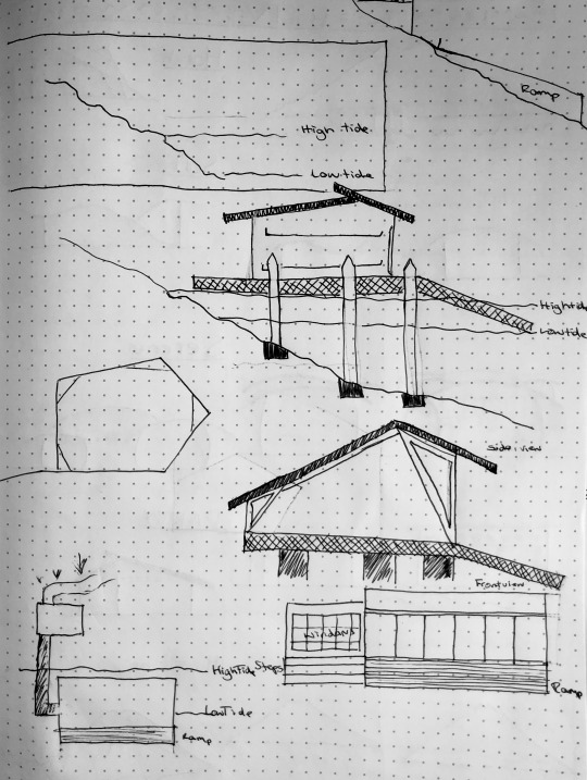
Site
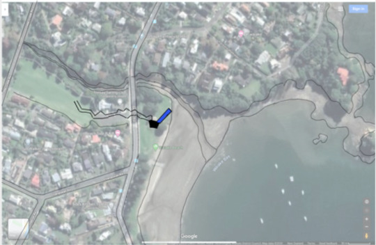
My site was Waiake Beach near Deep Creek stream, as shown in the diagram. The engineering around the pools is intended to flood with the spring tides, with the pre existing sea wall. The structure borrows the idea of Pilotis from Le Corbusier Farnsworth house, so when there is an extreme flooding event the structure will not be destroyed, this also helps that when there is changes in sediment around the structure, it will be able to do so without the building being in the way.
Design
We were also tasked to address what happens: (1), Under; (2) the threshold between over and under; and (3), Over.
In my design I addressed (1) Under in the form of the redesign of the bridge, uncovering and letting the river breath at this public space would hopefully spark the discussion around the health of our local rivers and streams. How to care for them by preventing erosion without piping or using hard engineering structures that damage them. This can also been seen in the flipping of the traditional garden, by creating a hanging garden from the three ‘pergolas’ that protrude from under the main structure.
(2) The threshold between over and under; in the main plane of my design, the roof is intended to have a waterfall effect when it rains, this falls into the pool structure right below. I have imprinted the shape of Deep Creek river running through the floor of the structure from its origins in the upper watershed down to the sea. The building is intended to have the tides swell up around close to the building. This tidal movement links around the ideas of a daily ritual, as we near closer to the beach when we can on a daily/twice daily basis.
(3) Over is expressed with the intention to have the tides swell up around close to the building. This tidal movement links around the ideas of a daily ritual, as we near closer to the beach when we can on a daily/twice daily basis.
Plan

Elevation

Section

References
https://teara.govt.nz/en/tangaroa-the-sea/page-5
https://www.doc.govt.nz/about-us/statutory-and-advisory-bodies/nz-conservation-authority/publications/protecting-new-zealands-rivers/02-state-of-our-rivers/maori-values/
1 note
·
View note
Text
|OVER/UNDER| Creative Cross Section and Observational Storyboard. #1.
In this module, you will create an architecture inspired by the site conditions of your present location. We might be living in bubbles now, and feeling constrained, but those bubbles sit within wider architectural, environmental and geological contexts and are subject to the rhythms of daily, annual, and millennial activity. Great architecture often relates to or challenges site contexts through design and an associated narrative. You have already created new designs and explained them in earlier crits. This module extends this practice to a site that you are already getting to know well through the current lockdown situation.
History.
In this lockdown period I have moved back home to Waiake. Waiake has had a brief history
“The area of Waiake (meaning ‘water from below’ or spring) was visited by many, anxious to take advantage of the curative waters from the spring. It was believed that the Waiake spring contained strange health ingredients which would cure some ailments. At one time up to 800 Maori were known to be ‘taking the waters’. Sometimes referred to as Te Toroa, the earliest evidence of Maori occupation dates from about the 15th century. With the arrival of European settlers, a wine making company was established in the area, as well as a flax mill and saw mill at the bottom of what is now known as Rock Isle Road. Tobacco growing was also experimented with. Local supplies of flax were available from the land around Browns Bay. When this was exhausted the settlers turned to milling kauri logs brought in by scow from the Coromandel and around the Hauraki Gulf, and pine trees planted in the area 25 years previously.
Most development in the catchment occurred following the opening of the Auckland Harbour Bridge in 1959 and the area is now fully developed. Current land use in the catchment consists of 78% low density residential, 17% road, 4% open space, 0.4% commercial, 0.1% bush and 0.1% high density residential. The population of the Torbay area was recorded as 4,554 in the 2006 Census. Deep Creek stream has been heavily modified during urbanisation of the catchment and retains little natural character. ”

My Creative Cross Section/Under
My creative cross section aimed to capture the meaning of the name Waiake, as well as its relations to nearby historic sites from European history. The geology of the majority of the coastal North Shore is called ‘Waitemata Formation’ and is alternating layers of sand stones, mud stones and siltstones that accumulated in seabeds during the early Miocene period (16-20 million years ago) then uplifted through tectonic processes.
The Tor, just located off Waiake Beach is a ‘protected site of geological significance’ in the North Shore district plan, is an example of a coastal stack formed by the erosion of sandstone, a prominent ever evolving physical weathering process, from hydraulic action, salt-water weathering, wetting and drying as-well as thermal expansion and contraction.
I wanted to uncover the previous land use of the area, with the mapping of the settlement in Waiake, and the larger settlement of Albany village. In-keeping with this idea I discovered some images of the old deep creek stream that now runs down the valley cutting through the section of land we are situated on. During my research I uncovered the meaning of Waiake, meaning ‘water from below’ with the spring containing strange health ingredients which would cure some ailments. Deep Creek, now very modified, used to have these properties.
The Observational storyboard/Over
The Observational story board focuses on the activity of both my small bubble of my mum and my dog and the journey we make, from in the morning, as we walk to the beach, and around the house when we are both working, but also the interacting birds and trees, throughout the day.
7AM~ Sun rising, walk down to beach. The street lights are still on and dawn is breaking.
9AM~ View of the Kowhai tree from my window, the tree has few flowers left, some leaves are beginning to yellow, but the Tui’s are still flying together playfully. The raising sun on the eastern side of the house flooding the lounge and dining area.
12PM~ Working fro my desk, looking at the kowhai tree from my window, the floor plan shows me any my mums travel paths around the house.
3PM~ Broadened this idea of travel paths around the house, sitting outside and getting lettuce and herbs from the garden outside to prepare food.
7PM~ Moving to west side of the house, the setting sunlight floods the kitchen’s bay window, as if the travel of sun replays the movement that we made throughout the day.

Reference
https://www.torbay.school.nz/torbay-history/
1 note
·
View note
Text
|IN/TOGETHER| Party Pavilion Auckland Domain, Cherry Blossom Grove.
These photographs document my progress through the second version of the second exercise Paper Models by Andrew Barrie for ARCHDES 102: Design 1. Paper modelling was the technique involved throughout the design process by beginning by creating a 2 dimensional net on Rhino which was then translated into a 3 dimensional building.
Brief: To design a 36m2 party pavilion, with a focus on the party/dining space inside; site is cherry blossom grove in the Domain.We first began experimenting using rhino and making some design developments.


These three spaces were relatively conventional, and I felt like I could be more experimental with my design.


In the time moving from my initial designs to my final design, we also moved out of the studio and back home, where I do not have a printer or thinker paper, hence the hand drawn and cut elements.
By creating the subterranean design, I have essentially created the space to be dual purpose, the upper level is an exhibition space, light and open, so guests can catch their breath, get another drink, or socialise with others in a quieter space. The above ground above has the staircase footprint cut out of it, to have the stairs dramatically fall away and draw guests down to where the party actually happens. The journey to below the ground was very important to try to tie together the two spaces. Guests go through portal like encasement of the staircase that draws you into the performance space. There are windows that follow the contours of the land, also drawing some light into the space, making it feel less enclosed.
1 note
·
View note
Text
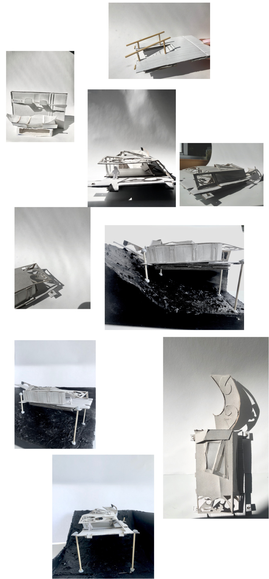
|FRONT/BACK| Kayak shed project at Islington Bay, Rangitoto Island, Hauraki Gulf. #4, Final Model.
In my final model, I was restricted to the materials I had laying around at home. I best tried to convey my concept in the 1:100 scale and with creating a site model the idea of slope worked as I intended it to.
I maintained the concept the same for the building but in the model making tried to convey some of the practical design elements like, how you get from your kayak onto the platform? or what is the storage solution for the kayaks inside?
I developed an idea of a half submerged ramp, where kayakers will be able to line them selves up, pull up the ramp and use the handles to safely and securely get out of the kayak, minimising the risk of tipping out and falling into the sea, or loosing a paddle into the sea, even if the wind picks up or a swell develops.
The storage solution I decided upon was: simple was best. A secession of racks spanning the length of the building off to the side would allow there to have the space for looking at the sky and education space whilst still having the intent of the building being functional and accessible. The kayak rack is at about waist height, to allow for single kayakers to still be a able to lift their boats without strain. The paddles are stored higher up as they can be lifter easier. There is small lockers under the kayaks for storage of life jackets, jackets, spray skirts or another bags that you do not want to take to the summit with you or even just the picnic area, and don't want sitting in the hold of the kayak that may be wet from the journey.
The building itself has a series or triangular skylights on the roof to allow for star gazing from the shelter of the building. The building is kept at a low profile as when looking out from the land it is not being invasive of the view across the bay. I wanted there to be two entrances to the building and for both of them to be been left open, thus allowing the view through to the ramp and the sea by unrestricted, as well as metaphorically showing the bridge from the land to sea being thoughtful and sacred. The curve in the gally ramp is curved allowing for more time to ponder this journey as you travel through the different zones of nature. The landward opening of the building faces due east, allowing for the sunrise to flood in, whilst there is a series of windows on both sides of the building to allow the northerly light come in, and the southerly views to also be seen.
2 notes
·
View notes
Text
|FRONT/BACK| Kayak shed project at Islington Bay, Rangitoto Island, Hauraki Gulf. #3, Concepts.
By using the concepts discussed in my research I developed these sketch concepts. I decided that making my design would aim to be as sustainable as possible.
Multipurpose
Adhering to this principal, I did not think that having a single use space, just for kayaks, would be a sustainable use of the land/sea area that the architecture is on. Thus, connecting the building to the Maramataka, I believed that the purpose of the building could become a observatory, where people can escape from the big, bright and noisey city to reconnect with the nature around them. Being over 15km from the city centre, the light pollution would significantly diminish, whilst still being quick and accessible for Auckland residents (the most likely repeat users of the building).
Materials
I was aiming to use recycled timber cladding for both the exterior walls and the roof. By using a seamless wall to roof design is technically challenging, as there needs to be a double roof design, it will creates a relaxed ambience and be more submersed into the landscape. I like the way timer ages, and discolour due to the different environmental conditions that it has been subjected too. The timber clad roof consists of a fully watertight membrane that has been applied plywood clad roof, with timber battens installed over insulation. Timber for the roof must be dimensionally stable, as a pitched roof will collect more ultra violet rays than in a vertical application. Selecting durable timbers with a vertical grain orientation is a suggestion, as “quarter sawn” or vertical grain timbers are proven to be more stable in highly exposed applications.
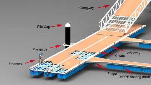
Floating
To reduce land being taken up I have opted for a design that floats on the water, much like a pontoon, as shown in the diagram below. To fix the platform to the seabed there would be cemented poles, and have pile guides attached to the floating platform.
Architecture
2 notes
·
View notes
Text
|FRONT/BACK| Kayak shed project at Islington Bay, Rangitoto Island, Hauraki Gulf. #2, Emoticons.
Back and front emoticon using keyboard symbols to show a section, and front and back of different emotion inspired buildings, or ones that are inspired by feelings of the environment.
“What is it about the site that can be developed into one idea that can be represent the whole design? What are the spacings and relationships between the different functions? What are the circulation paths? Can I do a diagram of this? Can I do three different diagrams of solving these inter-related problems? This is particularly important because often there is no one solution, you might think of several. It is important to diagram these and then evaluate which one is the best.” - Diane Brand.
The purpose of this exercise was to begin thinking about the site and our ideas for buildings from a 1dimensional view, but to think about the profilings from both a front and back perspective.
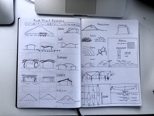
There are some sketches on the right hand page showing materials and some research and sketches on the kayaks for the next phase of development.
1.Harsh 2.Soft 3.Serene 4.Party 5.Horizon 6.Bridging of nature 7.Rocky 8.Ripply 9.Wavy 10. Materials study
1 note
·
View note
Text
|FRONT/BACK| Kayak Shed project, Islington Bay, Rangitoto Island, Hauraki Gulf. #1, Research.
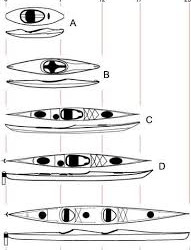
The task involved the design of a public kayak shed on a site in Islington Bay, on Rangitoto Island in the Hauraki Gulf in the Auckland region. The minimum design requirements for the project was: storage for 8-10 Kayaks of variable dimensions (3.3m, 4.3m and 5.3m) to protect them from rain, wind and sun, along with seating for 4+ people.
First and foremost, Research.
Identifying the brief: to understand, apply and integrate the principles of landscape context, topography, micro-climate, structure/roof/wall and materials to the ideation and design of a small shelter at Islington Bay, Rangitoto Island in the Hauraki Gulf.
- Storage for 8-10 kayaks of variable dimensions (3.3 meters, 4.3 metres and 5.3 metres).
- Shelter from rain, wind and sun
- Seating for at least 4 people
End user: Public, Kayakers that are visiting Rangitoto.
History: Rangitoto is the most recent, largest and least altered volcano in the Auckland Volcanic Field. This is made up of around 50 small volcanoes that have formed over the last 250.000 years. Rangitoto makes up nearly 60% of the total volume of material erupted. It was formed by at least 2 eruptions 600-700 years ago and is now about 260 m above sea level and 5.5 km wide.
Rangitoto is māori for 'Bloody Sky', with the name coming from the full phrase Ngā Rangi-i-totongia-a Tama-te-kapua ("The days of the bleeding of Tama-te-kapua"). Tama-te-kapua was the captain of the arawa waka and was badly wounded on the island, after having lost a battle with the tainui iwi at Islington Bay.
Geology: Rangitoto consists of scoria cones on top of a broad ring of lava flows. A moat like ring around the summit is due to subsidence of the mountaintop as underlying lava flows cooled and shrank. When it erupted 600-700 years ago over an unknown time span, the sequence of events was likely to have been a violent pyroclastic eruption as cold sea water met molten rock, creating an explosion crater and a tuff ring.ongoing fire fountaining built scoria cones once water could no longer reach the magma lava flows from the base of the scoria cone.
Vegetation: The lack of soil, very little water and high temperatures has created a distinctive yet developing plant population. Colonisation by lichen, moss and algae has been followed by the establishment of over 250 species of native trees and plants including ferns and orchids and the largest pohutukawa forest in New Zealand.
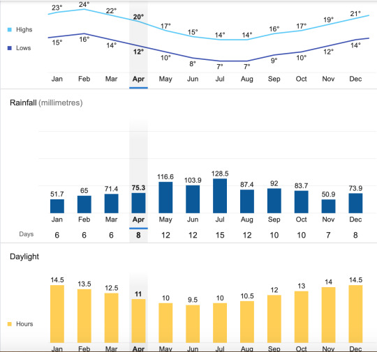
Climate: Temperature, average highs of 20-24 degrees Celsius in summer, and low temperates in winter are averaged at 7 degrees Celsius.
Rainfall, ranges from 50.9mm of rain per month in summer to 128.5mm per month in winter
Wind, there is a southwesterly prevailing wind direction, meaning that Islington Bay is sheltered from the cone providing a safe anchorage for boats and calm wind for kayakers.
Site: possibly the most important identification for the research process. I choose a site that was well connected to preexisting paths and clearings on land, at minimise the environmental disruption as much as possible.
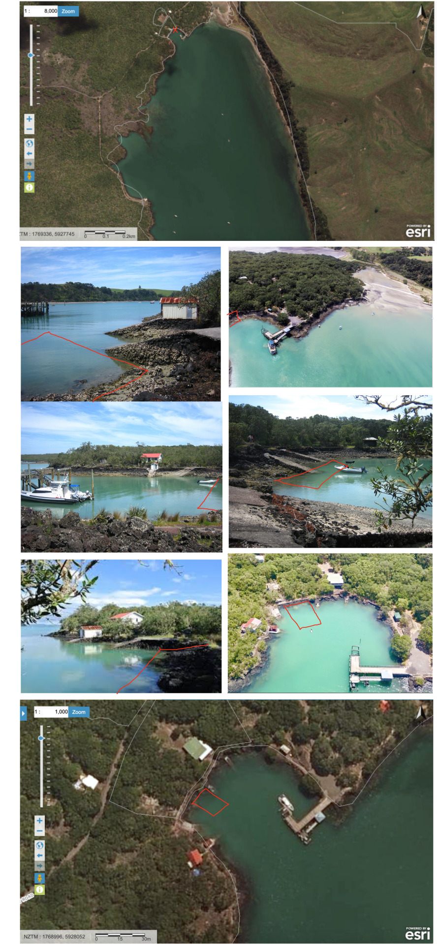
Tides: 3.0-3.5m tide differential.
Concept: Looking into the indigenous history of Rangitoto I discovered that there was a rich history involving several Māori myths. One such story tells us about the children of the fire deities, who lived in the Auckland area. It goes like this; One night a 'tupua’ couple, started to argue. This couple were children of the Fire Gods. In their argument they cursed the fire deity Mahuika. Mahuika heard them and went to Mataoho, the deity of earthquakes and eruptions. He sent an eruption to destroy the couple’s mainland home on behalf of Mahuika. As a result, their home was swallowed up by the earth to become Lake Pupuke on Auckland’s North Shore; this led to Rangitoto rising out of the sea. When mist surrounds Rangitoto, it is said that it represents the tears of the couple as they weep over their lost home.
There is a strong connection between the land and the people. This is exemplified within the Maramataka. Traditionally, Maramataka guided many activities in the lives of iwi communities, such as fishing, planting, harvesting and gathering. The phases of the moon marked the passage of time through the year and the Maramataka also noted the four seasons. ‘Maramataka’ translates as ‘moon rotating’. Matariki is a star cluster which appears in the night sky during mid-winter. According to the Maramataka (the Māori lunar calendar), the reappearance of Matariki, brings the old lunar year to a close and marks the beginning of the new year. Hence, Matariki is associated with the Māori New Year. Matariki signals the Māori New Year. It is a time of renewal and celebration in New Zealand that begins with the rising of the Matariki star cluster (the Pleiades or Seven Sisters).
tūpuna developed the maramataka based on their close relationship and understanding of our taiao. It connects the whenua, rangi and moana. By closely observing the environment, it is able to identify days each month that were better suited for particular activities and to help predict the season ahead, for planting, fishing and harvesting while also telling us high and low energy days, the effect those days can have on people’s moods and how you should best spend your day.
Traditional architecture of the early Marae meeting house, incorporates celestial alignments. For example, the outer porch faces the rising Sun, the Milky Way is depicted on the ridge beam. The Milky way is often referenced by its shape as a fish: Te Ikanui—the great fish.
1 note
·
View note
Photo


These are the photographs from my first exercise, Here and Now by Lynda Simmons for ARCHDES 102. The first photo (my Abstract) are of one of the works from my Submission Portfolio and are edited to produce different abstract qualities in the work.
I then made an Atmospheric Model taking the textures, colors and abstract qualities from my Abstract and photographed it in ‘plan’ and ‘section’ to produce qualitative characteristics. With this second image tries to capture the depth that was missing from my first image, a ‘tree’ was made from wire, I wanted it to add depth to the background, so, I added the layered paper (some curved the other intersecting the two) in the background. Through using the active line trace tool I was able to get good detail from the branches of the wire, but little depth from the paper in the background hence why I focused on looking through the branched into the ‘cave’.The waving and curling lines to me showed an enclosed series of spaces in section. There is a strong link to develop this into a cave architecture aka rock-cut architecture, to take this project further I would refine this from a conceptual sketch and something more buildable and usable.
The next step was to take the photograph and extract the quantitative ‘toolkit’ characteristics to make ‘measured drawings’ using Illustrator. These ‘toolkit’ lines helped produce a Partial Section through a spaces where people can use and explore, or live in.
2 notes
·
View notes
Text
Analytique Drawings: Villa Savoye


Media drawing module, quick 20 minute analytique drawings of the Villa Savoy.
3 notes
·
View notes