
Don't wanna be here? Send us removal request.
Statistics
We looked inside some of the posts by bigislandbigdreams and here's what we found interesting.
Average Info
Notes Per Post
1
Likes Per Post
1
Reblog Per Post
0
Reply Per Post
0
Time Between Posts
8 days
Number of Posts By Type
Photo
2
Last Seen Tumblr Blogs


Fun Fact
Tumblr.com rank in the US is 25.
Photo

It is a common thing for us to imagine visiting the burial place of a person, but how common is it for us to visit the birthplace of a person? What does it say about the importance of a person if even their birthplace is commemorated? The birthplace of King Kamehameha I is marked on the West Side of Hawai’i and often visted. King Kamehameha I, likely born 1758 during the passing of Haley’s comet, is revered by many as one of the most important figures in Hawaiian history. He is most known for being the first king to unite and rule of all of the Hawaiian Islands.
A little back story: Kamehameha I sought to unite the Hawaiian Islands from 1782, the battle of Mokuʻōhai, until 1810, the concession of Kaumualiʻi. This all began in 1781 after the death of the then Aliʻi nui, Kalaniʻōpu (great king of Hawaiʻi Island). After his death the island was divided in their support for a new king. The previous kingʻs first born son, Kīwalaʻo, was seen as the most appropriate heir, but many saw him as weak. Kamehameha defeated him in the Battle of Mokuʻōhai in 1782.
Another son of the previous king, Keōua Kūʻahuʻula, was also supported as the successor to Kalaniʻōpu. He was seen as a great warrior, and he also challenged Kamehameha I. Although he escaped from the battle of Mokuʻōhai, his armies went through battles for power for many years, and even lost two thirds of their manpower to an eruption of Kīluea in 1790. His last trip to the West side of the island was by invitation of King Kamehameha I. During what was to be a peaceful meeting, we was killed and Kamehameha took the title Aliʻi Nui (great king) of Hawaii. Some Hawaiians living in the area are still supporters of Keōua as they see him as a more rightful heir and see his kiling as an assassination. Kamehameha went on to battle for the sovereignty over the rest of the Hawaiian islands for the next 19 years.
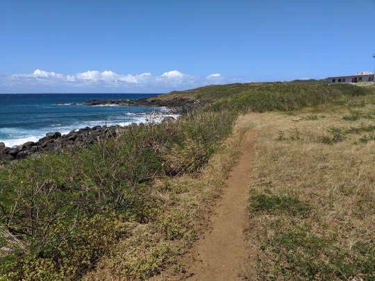
If you want to visit the birthplace of King Kamehameha I and pay your respects to this powerful warrior king, head to Hawi. Near mile marker 20 on Akoni Pule Hwy (270) there is a makai (toward ocean) turn off on Upolo Airport Road. Follow the road down to the coast and turn left at the airport. Then continue along the coast on a 4x4 worthy road. I would not take my little Hyundai Elentra, but I cannot make your decisions for you. This road is rough, but it will pass the Moʻokini Heiau and continue on to King Kamehamehaʻs birthplace. After feeling the power of this place I recommend taking lunch just a little further down the road. There is a small turn of with three trees for nice shade and a peaceful ocean view.
If you do not have 4x4 capabilities there is another option listed online, but I am not 100% sure about the legality of it. If you take Old Coast Guard Rd (near mile marker 18 on Akoni Pule Hwy 270) down to the coast and park in a small rough lot. Facing the ocean from this parking lot you will see a trail off to the right. If you follow this trail one and a quarter miles past homes and abandoned buildings you will reach King Kamehameha Iʻs birthplace from the other side. Please note that there is a sign on the return trip marking part of this path as property of the state and passing on this side would be trespassing. However, while guide books may recommend this route, I do not. Please Kokua and walk from Upolo Airport road if you do not have 4x4.
Non-negotiables: Hat, closed-toe shoes Recommended: At least 2 liters of water if hiking, sunscreen, snack to eat at the beach.
Hike Difficulty: 1.5/5 (can be hot, but it is basically on a flat rough road) Hike Length: 0-4 miles (depending on your 4x4 capability) Hike Enjoyability: 3.5/5 (very pleasant on a nice day with the wind on your back) Destination Enjoyability: 3/5 (powerful presence, but not a lot to see) Field Trip Worthiness: 2/5 (kids would likely have to hike, worthwhile for a small group of Hawaiian history buffs)
As always, if you notice any inaccuracies in my posts, please let me know so that I can remedy them - [email protected]
0 notes
Photo


No adventure on the Big Island is complete for me without a trip to Makalawena Beach. There is of course a 4x4 road that you can brave to take you to the North Side of the beach, but the beauty for me is best experienced after a long, hot hike over gorgeous black lava fields of the 1801 Lava Flow.
Makalawena is one of three beaches that lie inside of the Kekaha Kai State - along with Maniniʻowali Bay (Kua Bay) and Mahaiʻula Bay. Start your journey by about 2.5 miles North of Kona International Airport; there is a makai (to the ocean) turnoff with Kekaha Kai State Park signage. After turning off you will drive about 1.5 miles on “unimproved roads.” They really are quite improved than a straight shot across lava fields, but it can get bumpy. Any 4x4 vehicle will find it to be a breeze, a normal sedan could probably make it, but it will certainly put some wear and tear on the car.
At the end of the road there are a few facilities and beach access. Drive all the way down to parking lot if you need to use the smelly composty type toilets in an emergency. Or, do as we do and park by the fence that has a path leading North from the road.
Follow that trail North for about 5 minutes and you will get to Mahaiʻula Beach, this is a great shady beach for kids to play at. It is also a perfect spot to trick the rest of your party by pretending you are at the “Secluded Makalawena Beach.” This is my favorite joke, but just FYI I am the only one who really thinks itʻs funny. After crossing Mahaiʻula Beach continue for another 10-15 minutes across the lava fields and you will come up on some green foliage which will let you know that your reward is just ahead.
Makalawena Beach is absolutely gorgeous. The sand is powdery and the water is brilliant. But, be warned the sun can be brutal and waves hide many sharp rocks underwater. Be safe and careful, the ocean is an unforgiving mistress.
Non-negotiables: Lots of water, reef-safe sunscreen, hat, closed-toe shoes, swimming suit, snacks Recommended: beach umbrella, water shoes, lunch, towel
Hike Difficulty: 2/5 (heat & sharp rocks) Hike Length: 2.7 miles, 50 minutes total (approximate) Hike Enjoyability: 2.5/5 (you are watching your feet most of the time) Destination Enjoyability: 4.5/5 (hot and very little shade) Field Trip Worthiness: 0/5 (not for schools, more for families)
As always, if you notice any inaccuracies in my posts, please let me know so that I can remedy them - [email protected]
1 note
·
View note