
Statistics
We looked inside some of the posts by buggyexplorer-blog and here's what we found interesting.
Average Info
Notes Per Post
4
Likes Per Post
4
Reblog Per Post
0
Reply Per Post
0
Time Between Posts
2 months
Number of Posts By Type
Video
1
Text
5
Last Seen Tumblr Blogs


Fun Fact
When “GIF” was named word of the year in 2012, Oxford Dictionaries U.S.A. credited Tumblr for pushing the word.
Video
tumblr
Buggy Adventures are back!
0 notes
Text
Buggy Aventures on tour part 1. Northumberland
Welcome everyone to Buggy Adventures. This is my first post in a few weeks and that is because the Buggy Explorer clan have had some holiday time. Now, with a 5 month old baby we didn’t exactly expect to be jumping onto a jumbo jet and heading off to sunnier climes. A few years ago we decided to invest for our future family life and took up caravanning. A great way for lots of inexpensive holidays, once you have made the initial lay out for the caravan of course. I mean, how many holidays and breaks away can most people say that they have in a year? Two, three or for those lucky enough perhaps four? Well without sounding like I am showing off, we can hand on heart say that we can have as many little holidays as the pennies allow for us. By staying on lovely caravan sites for as little as £14 per night it doesn’t exactly break the bank and with the North York Moors on our doorstep, we don’t need to travel very far. Think about how much a little B&B in the heart of a national park would cost you. So for me it is a no brainer.
Now this particualr break away was our main two week holiday of the year. Four nights in Northumberland, home in time to vote in the General Election with a few days at home and then part two of the holiday which is yet to come in my next blog post. So on a lovely sunny Sunday morning we hitched up our home on wheels, pointed the Beast and caravan in a Northward direction and headed up the A19 and A1 to Northumberland. We were booked in to a Caravan and Motorhome Club site called Nunnykirk. Looking on the map it appeared that there wasn’t much at Nunnykirk beyond the caravan site and that was exactly what we were looking for. Not only was it a bargain at £14 per night in June but it boasted to be nestled in lovely Northumberland countryside and a paradise for bird watchers. I am no bird watcher but it was so nice to see a heron fly right past our caravan front window on more than one occasion and watch all the pheasants roam the site and listen to their “toot toot” call. When we arrived we had a nice welcome from the warden, who took particular interest in Master Thomas and advised us on the more sunnier pitches. We found our pitch in the third and final section of the site, which was very spacious and with no hard standing on the site the place was lush and green. After getting pitched up we had a wander around to take in our surroundings and then retired to sit in the tea time sunshine for a drinkypoo.

Now, this is where the sun ended. Upon waking on our first morning in Nunnykirk the heavens had opened and they were to remain open for most of the rest of our stay. Typical. The country had enjoyed a few weeks of nice early summer weather and then we go on holiday and it pours down! So this did put play to much of our buggy exploring that we had planned to do. We are not just “fair weather” explorers but we now had Thomas to consider and we didn’t really want to take him out in the torrential rain. That wouldn’t have been much fun for the little man. So we resorted to exploring by car and visited places such as nearby Rothbury, Amble, Alnmouth and Anwick, dodging showers when diving in and out of the many independent shops and country inns and pubs. We did get one dry day, Wednesday and finally we were a able to do some buggy exploring!
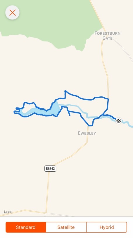
With our wet gear packed, just incase, we took ourselves off for a hike around the nearby Fontburn Reservoir. There was a car park at the reservoir but as it was so close to us we decided to walk direct from the caravan site making the walk a little over seven and a half miles long. We walked along the quiet minor road from the site to a “T” junction with the B6342 road and turned left. According the map there should have been a path not long after crossing the stream from the road which turned right to go through a small wood which linked up with the access road to the reservoir. However we could not find this path so ended up walking for about half a mile on the road before turning right onto the small access road to the reservoir. The map and directions for the walk got us a little confused again and you will notice on the map above that we darted off to the left and we were forced to retrace our steps back to the road. Once back to the road I studied the map and came up with my own route for the walk and we pressed on safe in the knowledge that we were now following our own directions and not someone else’s.
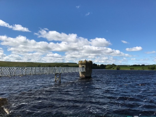
We reached Fontburn Reservoir and with it being a blustery day the water was rather choppy and the water very dark. The development of the reservoir, to serve the South East population of Northumberland with safe and plentiful drinking water, was passed by Parliament in 1898 with work starting in 1901 and it was completed in 1908. With Kielder Water just up the road I wonder just how needed it is in these parts now. Elsewhere in the country there aren’t enough reservoirs and after a few dry days you find some parts declaring hosepipe bans! And here you have a working reservoir with the largest artificial reservoir in the country a mere stone’s throw away!
After a little stop we turned left at the reservoir to walk through the car park keeping the reservoir on our right hand side for the rest of the walk. As it was a blustery day we occasionally lowered the rain cover on the buggy to keep Thomas from getting chilly with the cold wind. It must have been rather cosy in there as he was fast asleep, a common occurence on our buggy adventures actually! Once we left the car park we walked past some wooden holiday chalets on our left with elevated views across the water and the path soon turned from tarmac to gravel then grass. We entered a wood which we would now carry on walking through for about two miles. The path would rise and then drop back down to water level and meander away and then back towards the water and at times was quite narrow, making buggy pushing a little technical.

In between the narrow sections of path we walked over a number of wooden pathways built up off the ground protecting the soft ground from becoming damaged from boots and in our case, wheels too. This made walking easy and we were able to stop and take in the views of the water through the trees. At the end of the wood the waterside path came to an abrubt end due to the other side of the fence being a nature reserve and therefore protected. We walked left away fro the water uphill to a kissing gate, the first of a couple which we needed to lift the buggy over and then we followed the moorland path around the head of the reservoir. By this time the water was out of view and quite a few feet below our position. The path was on the side of a steep slope, was narrow and very uneven. Easilly the most uncomfortable path that I had pushed the buggy along so far in our adventures. Leela too was having to watch her step. Doing my best to keep the buggy from tipping over and not to topple over myself we carried on through some boggy patches until we met another moorland track. This was a particularly boggy area and Leela forged on ahead to pick the easiest route across to drier, firmer ground for the buggy. Following her lead I got myself and Thomas over without disappearing in the boggy ground! Back on wider and firmer paths we crossed a few streams and followed the path through a gate back into the wood and headed back down to the water’s edge. We watched a flock of Greylag Geese on the water get, rather menacingly, chased away from some much larger Canada Geese. I couldn’t help but feel a little sorry for the smaller, outnumbered family of Greylag Geese getting chased away from territory clearly claimed by their Canadian cousins!
After watching the potential of “Geese War” we carried on following our route which kept wandering away and then back towards the water for the next few hundred yards. We crossed a few streams on very narrow bridges that we barely got the buggy through. Anyone with a slightly large posterior would struggle with these bridges! We could see here that the water, which was still flowing fast after the rain, had previously run so high that it had flowed over the bridges which would have made the route unpassable. Thankfully the water had subsided. We then came to two gates at the end of the path and after a study of our map we took the gate to the right and headed once again uphil, away from the water and wooded area.
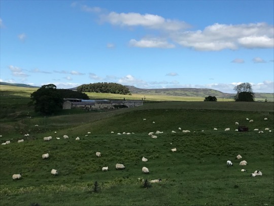
This was a steep grassy hill that got the blood pumping and at the top we rested and took in the lovely views for miles around. However we also noticed a heard of cows that had taken quite an interest in us. I mean, we must have looked silly to them, two people with bags on our backs pushing a funny red three wheeled thingybob in front! They wanted a closer look and headed towards us. This made Leela feel a little ucomfortable and urged me to start walking away swiftly. As a dutiful husband I honoured this request and we carried on pushing the buggy slightly uphill and left the cows behind. As we crossed into the next field we notice that the path again split. We had a decision to make whether to keep to the high ground, or take the path downhill back to the reservoir. While studying the map and our options another couple of hikers caught us up and were having the same debate. All four (five including Master Thomas of course) deciced to take the lower path back towards to the water’s edge and into the wood. As I was putting the map back in my pocket and taking on some water we noticed that our inquisitive friends were back, the cows! They were close and to be honest quite unnerving. I have walked through many fields with cattle in over the years but on this occasion these guys seemed a little too interested in us. We hurried down the hill with our new found friends following, at least until the lush grass became more appealing than the walkers and their funny three wheeled thingybob!
We had another kissing gate and Leela went through first and I lifted the buggy over with Leela’s help and we were now back on some nice even raised wooden paths for a while that we followed along the water’s edge.

By this time we were getting rather peckish. We had done about four miles, so over halfway and it was quite a strenous four miles. We decided that the first nice opening on the shores of the reservoir we would stop and eat. Plus Master Thomas would surely be getting hungry too by now. After about half a mile we found such a place and decided to have our main pit stop. I took off my rucksack and reached inside my fleece pocket for the map to put away into the rucksack and uh oh! Where was it? I no longer had the map. Now bear in mind that we borrowed this map and walk directions from the information hut back at the site, so I felt compelled to find it so that I could return it for future use. Despite the instructions being useless the map itself was good. So off I went re-tracing my steps thinking I must have dropped it at the top of the hill when we made our sharp getaway from the cows! Eyes scouring the path I walked swiftly back along where we had already been feeling sure that I would find it in the field in the middle of the cows who would surely not make it easy for me to retrieve it! And then, there it was, shining like lost treasure on the wooden path and I could rest easy, I didn’t need to go and negotiate its safe return from the cattle after all! I tucked it safely into my inside pocket and headed back to Leela and Thomas to have some much needed lunch.
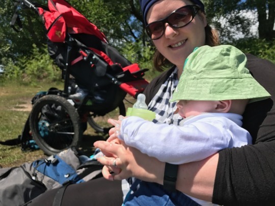
After eating in the sunshine and making sure that Thomas was well lathered in sun cream we headed off again. The wind had died down, it was much more pleasant for walking and the path was broad and easy with the water to our right no longer choppy and dark but light blue and twinkling in the sun. We hadn’t seen too many people on our entire walk, only three and it was obvious that much of the route was little used but by now we were headed back towards civilisation and noticed a few people fishing. I have only ever done a little bit of fishing. I spent one summer of the school holidays fishing with a friend at Scaling Dam, on the A171 road between Guisborough and Whitby. I caught a few Rainbow Trout and enjoyed it too. When I was younger than that as a family we visited the Pickering Trout Farm and my Dad and I had a competition of who could catch the most fish. I forget how many we both caught but I know that I won, easily actually! I have a photo somewhwere of us both posing infront of our caught fish, me looking rather smug and my Dad not so much. I can’t wait to be able to do things like that with Thomas when he is older. I have a fishing rod given to me by my Father-in-Law and as we were walking past the fishermen I remember thinking how I should get kitted out and use it.
The waterside path ended at a car park at the dam end of the reservoir and we joined a tarmac road. We turned left and walked towards the water treatment works with a rather magnificent viaduct dominating.
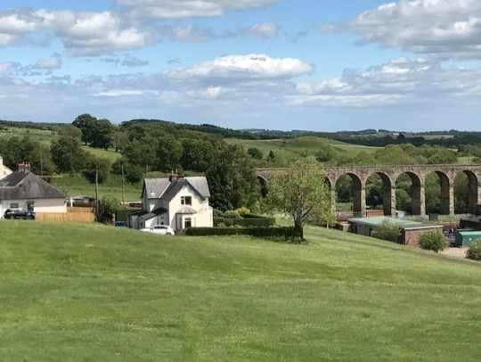
We walked downhill to the end of the road by the buildings on our right and followed a little used and overgrown path through a gate on our left running parallel with the old disused railway line on our right. We then reached some old ruins that appeared to be that of the old Fontburn Halt Railway Station. The railway line was authorised by Parliament in 1859 and the Wansbeck Railway Company begain buildng the line from Morpeth to Reedsmouth. As this was costly the line was built in sections and was not fully completed until 1870. Orginally the line was developed to serve lime works and a local colliery at Whitehouse but in 1923 the line became part of the London and North Eastern Railway to carry passengers. By 1952 though the passanger trains were withdrawn and in 1963 the line finally closed. The viaduct is an impressive piece of engineering though and is a lasting reminder of times gone by.
Just after the old ruins of the once busy train station we reached a farm road, turned right and followed the undulating farm road for the final stretch to the B6342. We turned right to follow the road downhill and then a left turn into the minor road taking us back to the caravan site.
A nice walk with some challenging sections for the buggy and one that I would recommend if you happen to be visiting the area. A little over seven and half miles with 614 feet of elevation gain, it doesn’t have any prolonged hills but rather a number of short sharp rises to contend with. My advice would be not to start at the caravan site if you happen to be staying there but to drive the short distance to the reservoir car park and start from there. Yes it shortens the walk somewhat but it is much safter than walking along the B6342 which is quite busy and twisty with no pathway to walk along. I can not find any details of parking charges online but it did look like there is some development going on at the reservoir visitors centre such as a children’s play park, so it would not surprise me if parking charges were introduced soon, if they are not already. So make sure you have some change just to be safe.
We were back to wet weather for our final full day at Nunnykirk and a visit to nearby Rothbury showed just how much rain had fallen during our stay as the River Coquet had breached and flooded the riverside walkway and car park. Thankfully the stream running through our caravan site did not breach but it was running rather high and fast and apparently the site is susceptible to flooding!
The day of our departure was torrential rain and we were totally soaked to the skin packing up and taking down the awning and we headed back South to Teesside in continuous heavy rain!
Make sure you watch out for my next blog, another holiday special when we visit God’s own country, North Yorkshire and the aptly named North Yorkshire Moors Caravan and Motorhome Club Site where we once again aim to boldly go where no buggy has gone before………
#hiking#buggyadventures#buggyexplorer#buggy#walking#countryside#outdoors#outdoorpursuits#baby#family#kids & family#caravanning#holiday#caravanholiday#northumberland#nunnykirk#caravanclub#fontburnreservoir#reservoir#waterside
0 notes
Text
Lower Rosedale Hike
Hi everyone and welcome to Buggy Adventures. In this blog I get to share with you one of my favourite walks. It is a favourite of mine for a few reasons. One, because it holds sentimental value as a walk I have completed a number of times growing up with my parents. Two, because of the stunning setting of Rosedale and three, it features two wonderful North Yorkshire pubs, one of which recently held the title of Yorkshire’s best pub. At just over eight and a half miles it is certainly worth donning your hiking boots but not overly stretching most people’s walking capabilities.

So Leela and I strapped Thomas in his car seat and we set off to Rosedale. We had arranged to meet Maggie and Joe at the car park of the White Horse Inn at Rosedale at 10.30am.
Perhaps I should take this opportunity to introduce you to Maggie and Joe. Joe and I have been friends ever since we were at Prior Pursglove College in Guisborough together back in the midd 1990′s. Through Joe I also became very good friends with Joe’s slightly older brother Jamie and their younger sister Lucy. I sort of became the other brother really and we all shared a common interest in outdoor activities such as mountain biking, camping and hiking along with drinking beer and nights out! Joe, Jamie and I would often pile into one of our cars and head over the A66 to the Lake District to take on some hiking, climbing and camping. Sometimes we would wild camp in our tents, find a remote bothy to spend the night or a camp site around the Keswick and Borrowdale area. Usually beer would be involved as we would stop off at a supermarket en route to stock up on cans of Boddingtons or Tetley Smooth Bitter and our rucksacks would be crammed full of cans for the outward trip. The return trip would be so much lighter with the empty cans squashed up! There were a few other occasions where we would set off in the direction of Keswick with the best of intentions to camp and hike only to be distracted by the many pubs in Keswick and the most hiking we ended up doing was walking up and down the high street calling into pubs. When Leela and I married in 2012 Joe was my best man, so safe to say we are good mates. Maggie and Joe met around 2010 and with Maggie’s own passion for the outdoors it was obvious that they were a perfect match for each other and they married last summer. Now we all try to meet up as often as we can for walks or camp trips.

Right back to the present day. Maggie and Joe arrived shortly after we did and after popping into the White Horse to check that we were ok to park our cars in their car park we set off. The walk begins by following the farm track from the pub’s car park in a South Easterly direction towards Lastingham, our halfway point. It was a warm sunny day so Leela ensured that Thomas was well lathered in sun cream and I made sure that the buggy’s hood was up sheltering the little man from the North Yorkshire sun. The track is home to a few houses on the right hand side of the track all with stunning views over the very pretty dale. One of the houses has an art studio which is sometimes open to the passing walkers to call in. As we chatted together the walk seemed to be going by with ease. We soon found ourselves at the end of the farm track and at this point the path becomes a single tracked moorland path. There a number of paths to choose from here but it is the path that hugs the wall on the left hand side that needs to be followed. Now the terrain became more challenging for the three wheeled buggy but as it a “go anywhere buggy” I was determined that the buggy would prevail and prevail it did. The path twists and turns, goes up and down, over rocks, boulders and ruts with relative ease. Or perhaps it is down to the awsome driving! At times Joe offered to help carry the buggy but I am determined that the buggy driving can be done by one person as much as possible. By picking the two back wheels off the ground and using the fixed front wheel as the only contact with the path I was easily able to guide the buggy along the single track and over any obstacles. This part of the path continues over for at least a couple of miles giving wonderful views as a reward. Once again Thomas spent most of this section asleep, so he certainly didn’t mind the bumps and rocking incurred.
We stopped at the end of the single track where we met a farm on the left and a remote tarmac road named Askew Rigg Lane. We took on some water and one of our cheese and salami ciabatta buns, we really must think of some new sandwich fillings! Maggie and Joe delved into their packed lunch too and I felt a little envious of their choice of beef or ham and pickle buns!

After resting a little while under the shade of some trees we set off along Askew Rigg Lane which then becomes Bents Lane. At the end of the tree lined lane we came to a “T” junction and turned right onto Syke Brow and followed this road for about a mile into the “chocolate box” village of Lastingham, our halfway point of the walk.
At Lastingham we called into the wonderful Blacksmiths Arms. Opposite the pub is the church of St Mary’s which is a stunning church. There is an ancient crypt under the church which is well worth a visit. The crypt was built by Stephen of Whitby when he refounded the Saxon monastery in 1078 and the crypt was built over where it is thought that St Cedd is said to be buried. St Cedd was a missionary from Lindesfarne who founded the orginal wooden monastery around AD 654. The massive church was never finished though, probably owing to William the Conqueror’s ‘Harrying of the North’ and for a number of centuries the partly erected church fell into decay. Between the 13th and 17th Centuries the church was again in use but was rebuilt in the 17th Century. The huge Norman pillars in the crypt are surviving evidence of the scale of just how big a monastery was planned before being abandoned all those centuries ago.
Back in the rear garden of the Blacksmiths Arms we enjoyed a very refreshing drink and packet of crisps to re-energise us. We enjoyed the break and Thomas got the chance to leave the buggy and certainly enjoyed the attention he received from Aunty Maggie and Uncle Joe.

Now rested and having polished off a rather nice pint of Saltaire Blonde it was time to get moving. It is worth noting that the Blacksmiths Arms does not have any baby changing facilities, so you may need to do a nappy change alfresco, as we did! Thomas took his place back in the buggy and we headed back through the village and turned left onto the High Street which heads steeply uphill and passes the Lastingham Grange Hotel at the top of the hill. Joe offered to do some buggy driving and I must say, he appeared very much at home at this.

At this point the tarmac ends and we entered through a gate onto the moor where there is a bench with lovely panoramic views. As we hadn’t been going for too long after our pub break we carried on and took the path going straight over the moor signposted for Rosedale. Joe carried on with the buggy driving and shortly after we passed a walker who complimented Joe on pushing the buggy so far. He had only been driving for 20 minutes but took the praise modestly! It is actually surprising that this path continues at a slight gradient all the way from the top of Lastingham High Street to the ancient Ana Cross which we were aiming for as our final sandwich stop.
Ana (Ainhowe) Cross is one of the 37 crosses and ancient markers that are found on the moorland. In fact, Ana Cross is often regarded as the finest example. I have visited this cross on many occasion with my parents at various times in my life, so it is quite fitting that I am now able to visit with my own family. Ana Cross is hugely exposed and at three metres high has often required repair work to ensure it stands to this day and beyond. It is hard to believe that it was once eight metres high. What a sight that must have been. We all took the time to rest at the base of the cross and ate the remainder of our packed lunches knowing that it is all down hill from here to the finish.

Now we headed along the last few hundred yards of the the moorland path to reach the Hutton-le-Hole to Rosedale road at the top of the famous Rosedale Chimney Bank, which we were about to head down. At this point I made sure I had the safety strap attached from the buggy to my wrist and ensured that Thomas was well strapped in his seat. Why? Because this is the steepest road in the country. It is named “Chimney Bank” as there was once a tall stone chimney here, part of the remains of the ironstone mining that took place at Rosedale. The chimney was dismantled in the 1970′s when a local land owner convinced the authorities that it had become unsafe but many of the locals were sceptical of this and insist that the landowner wanted the valuable stone to use on his land. It is such a shame that it no longer stands but many of the ironwork kilns are still visible now. However I will save this information for a future blog as the “Upper Rosedale” walk takes in much of this history and it is one that we will include in a future Buggy Adventure.
We headed down the one in three gradient road passing some very remote terraced cottages on our left, again left over from a bygone industrial era for this very tranquil dale. As we descended towards the White Horse Farm Inn we passed Rosedale’s nine hole golf course on our left and opposite the road to the hamlet of Thorgill we turned right into the car park of the pub with the last quarter of the bank remaining untouched which heads into the village of Rosedale Abbey. Again more information of this lovely village to come in a future adventure.
Just under 8.5 miles and 1,060 feet of elevation gain, mainly in warm sunshine apart from the last few miles, made for an enjoyable and slightly testing walk, especially the single track which really tested the buggy’s “go anywhere” capabilities. Time for a refreshment stop outside the White Horse Inn, which in 2012 was voted as Yorkshire’s best pub and an opportuity to soak in probably one of the best beer garden views you are likely to find. Even Thomas found the walk thirsty work as he was trying to reach for Mummy’s cider!

Next time Buggy Adventures goes on tour as we head to Northumberland.
Boldy going where no buggy has gone before……….
#hiking#buggyexplorer#buggyadventures#walking#outdoorpursuits#outdoors#northyorkshire#yorkshire#northyorkmoors#nym#rosedale#rosedaleabbey#lastingham#stmaryschurch#blacksmithsarms#blacksmithsarmslastingham#moors#moorlandwalks#whitehorsefarminn#chimneybank#anacross
0 notes
Text
Guisborough Woods
Welcome again to Buggy Adventures. Wow, they seem to be coming thick and fast! Well this particular blog brings to you a nice short 4.5 mile circular in Guisborough Woods. So if you don’t have much time but fancy squeezing in a nice walk and with 550 feet of elevation gain, so it gets the blood pumping, then this is a good one.
I have also discovered how to add photos to my blog, I’m getting so tech savvy these days and courtesy of Strava I will add a route map at the start of each blog. There are one or two pictures added to my two previous blogs, so please feel free to scroll down and re-visit.

Joining us today on our Buggy Adventures is Thomas’s Grandad - my Dad, Keith and Lily the poodle. Growing up I was an only child and to be honest, I loved it. Not having to share my CD’s, no squabbling over which sibling gets the bigger bedroom, or battling over who got the keys to my Dad’s Renault 5 once I was of driving age! So having a dog constantly in the family was my equivalent of a sibling. Misty, our wonderful family pooch, was a miniature poodle with attitude. He really thought he was head of the family and quite frankly, he was! Misty often covered two or three times the distance than we did on our family hikes. Then we had Louis, a white standard poodle who was such a handsome devil and he knew it too. Louis also loved his walks in the woods and hills of Guisborough with my parents. My Dad often shared his love of photography with Louis by going out on early morning walks in the woods in an attempt to photograph the perfect sunrise. Sadly we lost lovely Louis last year just before Christmas and it's fair to say the whole family was devastated. I still miss him so much to this day. My poor Dad was lost without his loyal companion and despite my parents saying that they weren't going to get another dog it was evident that there was a void. Lily was the perfect dog for my parents. A three year old miniature rescue poodle who had not had a very nice life so far and had been used purely for breeding. Now though she has been given the life she deserves with my Mum and Dad. Actually looking like a poodle now after some serious grooming, I was amazed at how well behaved she was off the lead on our hike. So, Leela, Thomas, my Dad, Lily and the Buggy Explorer set off on a walk all together.

We entered the Guisborough Woods at the top of the Pine Hills housing estate off Lyndale. All of the road names on the Pine Hills estate are named afer dales such as Farndale, Weardale and Rosedale. The path from Lyndale goes down a short but steep hill where it meets up with the old Middlesbrough and Guisborough railway line. Oh how Guisborough could now do with a train service to Middlesbrough, I think that it would be very well supported and would certainly take a lot of cars off the road. Cut backs are not only happening now as they obviously played a part in 1964, the last time a train operated on this line. Much of the old line is now walkways or built on, so no chance of it being re-opened.
Once at the old line we turned right and walked in the direction of the briliant Branch Walkway Cafe at the Guisborough Forest and Walkway Visitors Centre. If you are on the look out for a full monty breakfast, than you need not look any further than the Branch Walkway Cafe. Just don’t expect to be able to eat for 24 hours after and make sure you are hungry, really hungry. Their rocky roads are pretty special too. Anyway, as my Mum was preparing a lovely family meal for later in the day we avoided temptation by taking a left turn into the woods just before we got the the cafe. We immediately turned right and walked uphill past the adventure playground on our right amongst the trees. Thomas will love it here when he is older.
As we walked the views opened up to our right looking over Pinchinthorpe and the fields between Guisborough and Nunthorpe. In the distance you can see towards Flatts Lane and the Eston Hills with the busy A171 road linking Middlesbrough to Guisborough inbetween. Along this path we passed a few walkers one of whom had a dog which seemed to show some interest in Lily and decided for a good few yards that he no longer wanted to wallk with his owner and tried to tag along with us! Lily is not that type of girl though and she did not show one bit of interest in her new admirer and the dog finaly gave up and walked back in the oposite direction towards his owner who by now was out of sight!
We followed the path for its entirety and it came to a head at a concrete road which snakes its way uphill through the trees to Bousdale Farm. This concrete road was always a killer when I rode up it on my mountain bike years ago and guess what? Its a killer when pushing a three wheeled offroad baby buggy too! After one or two rest stops we all made it to the top at Bousdale Farm where we all decided on a rest and drink stop while taking in the views and a few photos.

Bousdale Farm has renovated some outbuildings turning them into holiday cottages and what a setting it is in. Within easy reach of Guisborough and the surounding area it has a feel of remoteness with some outstanding views of the hills. There were some very friendly goats in a field here and one of them was eager to make friends, or perhaps he just wanted whatever food we had on us. Since we were only on a short hike all we had were a couple of snickers bars and a bottle of water, so Billy the goat went disappointed!

We walked through the yard and through a gate into fields and we got a spectacular view of that mountain again, Roseberry Topping. It certainly dominates and you can see why it is nicknamed the Cleveland Matterhorn as it does share a distinct resemblance with its much bigger namesake. The summit once resembled a sugar loaf. Then in 1912 Roseberry Topping changed forever when the Western side of the hill collapsed, mainly due to alum and ironstone mining but also because of a geological fault. Apparently Guisborough is one of the more likely places in the country to have an earthquake, not that I have ever noticed! Due to the sheer West face following the collapse the Topping has since been compared to its big Swiss cousin.

So once through the first field we entered another via a metal gate and keeping to the left hand edge of the field we walked through to another metal gate and turned left to go up to the wooden gate oposite. Back onto well maintained paths we turned left and walked back into the Guisborough Forest. From here on it was easy pushing with the buggy rolling over well maintained fire track roads after the uneven tracks in the fields that we had just come through.
We carried on walking downhill and after a little while we turned almost back on oursleves to extend the walk a little. The paths zigzag their way through the woods and you can walk for hours without ever being more than a couple of miles from where you started! As we dropped lower towards the end of the walk we enjoyed a little break by a bench with a lovely view across rapeseed fields near to Home Farm on the Hutton Village Road. We admired the yellow carpet that spread out infront of us while munching on funsized Aldi Racer bars, which is basically a Snickers but half the price, as is everything at Aldi!

We finished the hike by walking along the track going past Home Farm and the idylic barn conversions with their spectactular views of the surrounding countryside and onto the Hutton Village road, where we parked the car on our last walk. We walked onto the Avenue and the final few minutes rolling back to my parents where a hearty meal awaited us.
A lovely way to spend a couple of hours in the local countryside.
Look out for the next Buggy Adventures blog where our very good friends Maggie and Joe join us for a hike which challenges the buggy’s capabilities in the heart of my favourite part of the country.
Boldly going where no buggy has gone before...........
#guisboroughforest#homefarm#guisborough#northyorkshire#roseberrytopping#branchwalkwaycafe#hiking#walking#family#poodle#dogwalks#dogs#countryside#outdoors
1 note
·
View note
Text
Where the Buggy Adventures began. Captain Cook's Monument.
Welcome back to Buggy Adventures. This is a special one, as it’s the first adventure. Read on to see how we get on with a circular hike from Guisborough taking in Captain Cook’s Monument.

After purchasing the Nipper Sport buggy just the day before and squeezing it into Leela’s little Daihatsu Charade, aka the golf buggy, to get it home, we were excited to use it and go out on a hike. As this was the first serious walk we had attempted since Thomas was born, Leela was keen for it not to be over strenuous. “Oh it’s about 6 miles and not too hard going” I told Leela. Well in my excitement, perhaps I forgot to inform Leela of the hills it involved! Oops!
Anyway, we parked our car, my slightly larger Kia Sorento, aka The Beast, on Hutton Village Road leading up to the very picturesque and Alpine-esque settlement of Hutton Village in Guisborough. We walked through the Village to the gate leading into Guisborough woods up a steep tarmac track commonly referred to as the Christmas Tree Bank. It’s called this as you were once able to drive up this bank at Christmas time where the Forestry Commission sold real Christmas trees. Due to mindless idiots who burnt down the hut where the staff operated from, a tree hasn’t been sold from here in about 20 years but the name of the bank has stuck.
Once at the top of the bank we turned right and left the tarmac of the bank onto fire track roads, which twist and meander their way through the Guisborough Woods. Shortly after we took a left turn onto the second half of another path with a name that once described it but it’s still known as, the Unsuitable. The Unsuitable was given its name as it was once a public road, there was nothing stopping you taking your Nova SR up here, not that you’d get very far. There were signs warning people that it was indeed unsuitable for motors. The path had deep ruts and after rain they formed mini raging rivers. This was mainly caused by the 4X4’s that would use the track to get up to the Percy Cross Rigg road on the moor. Now no traffic is allowed and the path is well maintained but still carries its common name of the Unsuitable.
Once up the Unsuitable we stopped for a break and delved into our bag of food for much needed sustenance. A small group of mountain bikers passed us and one made a comment about doing well pushing the buggy up the steep track. My stock answer to this has since become, “I wish Thomas would help me out by peddling faster!” The mountain bikers headed off through the gate onto Percy Cross Rigg, where the chatty lad at the back tried to bunny hop a low gate on his bike. It didn’t end well with him not clearing the gate and him being thrown off his bike! Thankfully it was only his pride that was hurt!
So after a break and a quick food stop at the top of the Unsuitable we took a right turn and followed a path that skirts the moor to the left and what was, until a few years ago, the tree line of Guisborough Woods to the right. There is a scheme designed to take Guisborough Hills back to its more natural deciduous wood rather that the pine trees as managed by the Forestry Commission. In the 1950’s the Government introduced managed forests all across the country to help get the country back on its feet after the Second World War, hence the Guisborough Forest. This section of the forest has now been cleared and is just tree stumps and the odd trunk of a tree which were left for the birds of prey to perch themselves on. It looks a bit like how I imagine the countryside of Europe which hosted the epic battles of the First World War!
Anyway, after a few minutes we left the Guisborough Woods and went through a gate onto the moorland. Here you can enjoy uninterrupted views for miles and also catch a view of Roseberry Topping. Standing at 1050 feet above sea level we can actually refer to the Topping as a mountain. Granted, not exactly in the same league as Mont Blanc but a mountain nevertheless. This being the first outing with the buggy, I thought we could save Roseberry Topping for another adventure. After all, I still feel as though I need the “L” plates at this stage. We hung a left turn and carried on over the moor towards Gribdale. We passed those same mountain bikers at this point, who we met on the Unsuitable, on their return loop and we exchanged the usual pleasantries as each passed us. To reach the foot of Gribdale there are two choices. One is to go down the steps to reach the road at the bottom, or the other to take a rutted path which bends its way down to the same point. Not wanting to attempt the long steps and risk bouncing Thomas around too much, we opted for the path. I once came a cropper on this path on my mountain bike going totally over the handlebars, doing a great somersault and landing with a very satisfyingly sounding splat in a load of mud! Again, like the mountain biker who tried to bunny hop the gate earlier in our walk, only my pride was hurt but turning up at my mum’s house after my ride there was no way I was allowed to cross the threshold caked in all the mud. This was a common occurrence when I still lived at home on the weekend. I’ve even been hosed down on the drive before even being considered entry!
As we reached the bottom we found the car park at Gribdale was chockablock. I’m all for encouraging people to get out into the countryside but I couldn’t help but feel a bit sad. I had been walking and cycling here getting on for 30 years and this was always a very pleasant spot. While cars have often parked here so that people can climb the path up to Easby Moor, aka Captain Cook’s Monument, I had never experienced it being so busy, noisy and unfortunately, dirty. I was always brought up to respect the countryside and everywhere else for that matter. I would never dream of leaving litter. Is it so hard to take home your empty drink bottle, or sweet wrappers! But that wasn’t the worst of it. As we walked through the gate to start the long climb the path was lined with little black plastic bags, all tied up and some tied to trees. I can’t work out what’s worse, allow your dog to leave a deposit,or pick it up with a plastic bag, tie it up and leave it! It’s hardly going to biodegrade like that, is it?! Better still, be a responsible dog owner, pick it up with the bag and carry it tied up until you come across a bin!
Ok, rant over now, back to our walk.
We pushed on for the summit and near the top we met a young family with twin boys about 3 years old. It’s so nice to see other parents introducing their young children to hiking. Both mum and dad had backpacks on to carry the boys for when their little legs couldn’t take them any further but at this point they seemed full of energy and were doing really well. The last couple of hundred yards or so to the summit turns stoney and steep. Traffic was busy here too with people walking up and down and it’s much narrower at this point. I really didn’t want to admit failure and ask Leela to help me get the buggy up that last few yards. So I dug deep and with some brute force I forged a way up the steep, rocky section to the top where the path levelled off. A quick check inside the buggy to make sure I hadn’t scared poor Thomas senseless but as he was sound asleep it was the final 50 yards of flat pushing to the monument.
The monument to Captain James Cook can be seen for miles around. Captain Cook was born in 1728 in nearby Marton, now part of Middlesbrough and went on to become one of the world’s most famous explorers. He was killed in Hawaii in 1779 and 48 years later in 1827 a banker from Whitby, named Robert Campion, erected the 60 feet high monument in memory of our region’s most famous son.
After walking around the monument a number of times, Leela eventually settled on the most sheltered side to sit and enjoy our lunch. It’s worth noting that it was particularly blustery at the top of Easby Moor. We made sure Thomas was well sheltered and then we tucked into our cheese and salami ciabatta buns and then we wasted no time in setting off due to the chilly wind.
We followed the Cleveland Way path and descended off the moor via a very rocky and steep path. I often lost my nerve on my mountain bike here but the buggy made easy work of the terrain. Lifting both back wheels off the ground and using the fixed single front wheel to steer we were down with minimal effort. This time Thomas was wide awake but seemed undeterred by the bumps and steepness. He’s going to love his adrenaline sports this boy! Once onto more easy wheeling paths we carried on the Cleveland Way walking through some lovely woodland until we came to a tarmac road named Dikes Lane.
We turned left onto Dikes Lane, which if we remained on for long enough would bring us back to the bottom of the climb to Captain Cook’s Monument at Gribdale. We wouldn’t be going that far today though. We followed the road downhill through a small but dense wood which then opens into a very pretty small dale with one or two farm buildings and holiday cottages dotted among the fields. We stopped by the first farm house and perched ourselves on a wall to feed Thomas. We had been out a little longer than anticipated by this point but as ever we were well prepared with food and water for us and milk and bottles for Thomas. Once the little man was fed it was onwards for the final climb of the walk and what a climb it is too!
It was at this point that Leela recognised this particular path from a walk we did a few years ago and she wasn’t overly impressed that we needed to go up it today! I could feel the daggers burrowing into the back of my head as I enthusiastically insisted it’ll be ok and we’ll be at the top in no time when I set off pushing the buggy up the hill. To be honest, I was also trying to convince myself as I was starting to feel the strain somewhat but please bear in mind that just a few months ago Leela had given birth and this was our first proper hike since April last year and it’s now May! I knew that she was doing really well and I was impressed by her determination but I was mindful to keep the mood positive and kept trying to motivate. I had also earlier told Leela that we would be back at the car by now!
The path quickly gets steep and is very rutted. Now at five feet six tall, I realise I am no giant but I found myself in a rut deeper than me and it was getting narrower and more difficult to navigate the buggy. This climb was taking its toll but I picked my way through the ruts and Thomas and I made it to the top. Leela wasn’t far behind and we rested a while and took on some water. It was quite warm now and the climb was tough but that was the last climb which I enthusiastically told Leela. However I just got a look and I knew she would be thinking “You also told me we’d be finished now, so I don’t believe you!”
We were now on Percy Cross Rig, which takes its name from a 13th Century cross marking an ancient road from Guisborough to Westerdale. We set off in the direction of Guisborough passing an old air raid shelter used by people during the Second World War who lit fires over the moors to confuse the German Luftwaffe so that they would drop their bombs over the sparsely populated moorlands, rather than the steel works and towns on Teesside, their actual target. From there on we could see the tree line of Guisborough Woods and we were soon at the gate at the top of the Unsuitable. We carried on down both sections of the Unsuitable, the bottom section running along the back of the huge gardens of the houses in Hutton Village. I always think how nice it would be to live there when walking through Hutton Village. Once at the bottom of the Unsuitable it was job done! Just a few hundred yards of tarmac road to the car.
It was such a good feeling that Leela and I had been able to do a proper walk and that we could take Thomas and introduce him to a part of our life that we want to form a big part of our family’s activity moving forward. Seven and a half miles in the bag with almost 1,300 feet of elevation gain and a maiden voyage for the buggy.
Join me again soon in my next “Buggy Adventures” blog to see how we fared on our next walk.
Boldly going where no buggy has gone before……..
#buggyexplorer#buggyadventures#kids & family#hiking#walking#outdoors#outdoorpursuits#guisborough#guisboroughforest#captaincook#captaincooksmonument#easbymoor#outnabout#letsrunstokesley
2 notes
·
View notes
Text
Introducing the Buggy Explorer
Welcome to my little blog. You’ll have to excuse me somewhat as I’m fairly new to this blogging malarkey. In fact, I’m brand new as this is my first ever blog, so I’m hoping in time I will get slicker with it!
Anyway, welcome and allow me to introduce myself. My name is Adam and I, along with my 5 month old Son Thomas and my wife and partner in crime Leela, will be taking you on our “Buggy Adventures”.

I have always had a passion for the great outdoors and could often be found with friends exploring the Lakeland Fells or tramping over the beautiful North Yorkshire Moors. I suppose I have my parents to thank for my love of the outdoors as when I was young we could often be found with our boots on or on a mountain bike in Guisborough Woods and over the moors. Growing up in the lovely North Yorkshire market town of Guisborough I had the outdoors literally on my doorstep.
Leela grew up in the wilds of Weardale, so also had a link with the outdoors and as an artist took great inspiration from this and nature and the countryside can be found in her amazing work. So when we moved up from camping under canvas to going away in our caravan we found we could spend even more time in the countryside, particularly around Lealholm in North Yorkshire, our favourite “get away from it all” place.

Then one April morning in 2016 at 5am, Leela woke me to tell me that she was pregnant, or at least that she thought she was! Bleary eyed and half asleep, this took a bit of sinking in! But it did sink in and that very day we had the doctor confirm Leela’s home test and we soon became very excited and quickly started planning the next chapter of our life.
Our regular hikes soon ended through some quite strange dizzy symptoms Leela experienced during the pregnancy and in time as Baby T, as we affectionately named our baby bump, grew hiking and walking became more difficult for Leela.
Fast forward to May 2017, we are now a family of three with a very healthy Thomas, arriving in our lives on December 27th at 2:15am. We are now eager to get back to our outdoor living and introducing Thomas to the ways of the countryside. The only problem was, how do we do this?! We had a great pram, which my Mum and Dad invested in for us, and a smaller pushchair come pram for nipping into town with. Both are great for what they’re designed for but not for getting off the beaten track. Even on the fairly smooth fire tracks in Guisborough Woods both felt that they would rattle themselves to pieces and Thomas must have felt like he was turning into scrambled egg!
Just how would we be able to put our boots on and start hiking with Thomas?! We looked into a backpack but quickly dismissed this idea as Thomas isn’t getting any lighter. Then on a visit to Stokesley, another gem of a North Yorkshire market town, we noticed in the window of Let’s Run (a brilliant independent running shop) the answer to our problem. A gleaming Out ‘n’ About Nipper Sport buggy! Tony and Shelli, who run the business, were brilliant and as owners of their own Nipper Sport were able to talk us through just how effective an outdoor buggy it really is. A quick test run up and down the Stokesley streets and Leela and I knew, this is how we could introduce Thomas to exploring the countryside and how mummy and daddy could get their hiking fix again! So, this is how the “Buggy Explorer” came about!

Join me again soon to learn of our first few buggy Adventures to Captain Cook’s monument, a stroll through the Guisborough hills with Grandad and Lily the Poodle and a hike with our very good friends Maggie and Joe in the heart of the beautiful North Yorkshire Moors.
To boldly go where no buggy has gone before…….
#buggyadventures#buggyexplorer#buggy#outnabout#kids & family#kids#outdoors#hiking#walking#family#letsrun#stokesley#letsrunstokesley
1 note
·
View note