
Statistics
We looked inside some of the posts by calculated-waywardness and here's what we found interesting.
Average Info
Notes Per Post
422K
Likes Per Post
253K
Reblog Per Post
169K
Reply Per Post
411
Time Between Posts
7 hours
Number of Posts By Type
Text
17
Last Seen Tumblr Blogs


Fun Fact
US Tumblr user growth rate is estimated to slow down to 4.1%.
Text
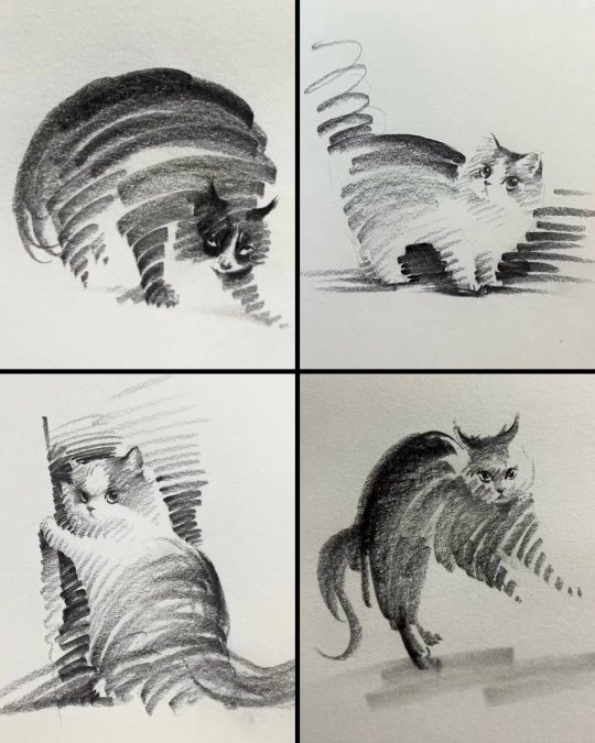
Chinese artist Shou Xin creates the most wonderful cats with just a few pencil lines
135K notes
·
View notes
Text
First papal decree to be typeset in LaTeX
88 notes
·
View notes
Text
“I don’t do math because I’m gay” “the gays can’t do math” “If I explain math on tumblr I’ll lose my gay card” all of you apologize to Alan Turing right now
67K notes
·
View notes
Text

Location of the Maker. Just in case anyone hadn't put this together yet. Obviously we don't know exactly how far the Titan extends in either direction, but we can be pretty sure from context clues that the Temple of Sacred Ashes, where Andraste was laid to rest (/returned to the Stone), is part of her Titan. Orzammar is so close by, and so notably resistant to the darkspawn even after all this time, that it's surely got to be part of the same, non-Blighted Titan.
The Maker Titan might extend as far east as Denerim, given that that's where Andraste was born, and as far south as Lothering, given that it was able to give Leliana a vision while she was living there.
I adore the symbolism of this, by the way. The Inquisition was literally founded on top of the Maker Itself!
61 notes
·
View notes
Text
Deep Roads Overlay Map
So, back in one of the earlier books of Dances in Darkness, I mentioned I had taken awhile writing because I was trying to work out all the locations of the Thaigs and Deep Roads relative to the surface. We know that the dwarven empire once spanned almost all of Thedas. Most of it has been lost. Only Orzammar survives.
During the Paragon of Her Kind quest in Dragon Age: Origins, we are given a “map” by whichever person you choose to support, which is ultimately a rough work-up of what their team has discovered so far. We know it’s maybe a little inaccurate. It’s absolutely not even remotely complete, and yet it has a lot of information there for us. The Warden uses it to reach the Anvil of the Void and yay, all is happy.
This is the longest portion of the bloody game, and tedious in parts. You visit a lot of locations, and have to fight your way through some fairly large areas. I have no idea if my timescale is correct for Dances in Darkness, but I use Dagna’s two weeks from Orzammar to the Circle Tower as a guide, so all my times in story come from that generalized figure (I count this as two weeks walking or slow riding). I guess it takes about as long to Redcliffe, and contrary to people saying you can sail to Kinloch Hold from Redcliffe in 2 days (one there, one back) in game, I’m not sure how that’s really possible unless you account for boats being amazing, and Templars not being angry at people sailing directly from Redcliffe to their Tower. I feel like there’s maybe something weird with that.
Ultimately the endeavour to work out the Deep Roads then actually came from a need to get my timescale right. In Dances, they’re on a very limited time schedule to work in, and I needed to know just how limited and if the time constraints set were even possible. So I needed to know how that Deep Roads map relates to the actual Thedas map of Ferelden to compare Dagna’s two weeks measurement (let’s trust her on that; she’s obsessed with the place and would probably know specifics like measurements given she’s a smith’s daughter who loves learning).
Looking at the basic Deep Roads map, we get this:

Now, at first glance, you look at this thinking right, compass rose there in the lower corner, so the Anvil of the Void and Bownammar are west, probably into Orlais, and Cadash Thaig is down south, and Orzammar is there in the north-east corner. Except this is not actually correct. We have several pieces of evidence that point to the fact that this map is not currently correctly angled.
1. This is a mock-up by Bhelen/Harrowmont men trying to find Branka. It was made by dwarves who have never been to the surface and navigate using stone sense (which is probably linked to lyrium and not to an actual magnetic direction). Therefore, there is no reason why dwarves would use north/south/east/west anyway.
2. It deliberately says on the map in the top right corner “to Frostback Mountains”. Since the Frostbacks are an entire mountain range, let’s assume this means to the mountain range itself, and that arrow up there is pointing to the range. The range therefore runs somewhat along the entire top edge of the map.
3. We enter Orzammar from the surface from a door that is facing South. The door leads into the Commons directly across from the Provings. The door into the Deep Roads is actually then off to the right in the level, meaning that the map should be showing the Deep Roads exit/entrance to Orzammar. And it does. If we angle the map again, we find that the map is angled incorrectly.
4. In one of the books (I think Stolen Throne?) Maric and Loghain and Rowan are fighting in the Battle of West HIlls (located up near Highever and Waking Sea and the Storm Coast). This battle goes spectacularly badly. Maric, Loghain, and Rowan only escape the battle by fleeing into the Deep Roads, where they end up somewhere in or around Ortan Thaig. They then travel through the Deep Roads to Gwaren to emerge, by which time everyone thinks Maric is dead, and this is some spectacular resurrection or something. It’s because of this previous journey that the Grey Wardens later try to get King Maric to help them navigate the Deep Roads after Rowan’s death (The Calling, I believe). This is the whole Fiona/Maric and Duncan and the Architect story here. The Architect is doing something sketchy in a Thaig called Kul’Baras, and he later emerges very close to or under Kinloch Hold itself. This information actually gives us locations of not one but three different Thaigs on the map. Kul’Baras is somewhere under Lake Calenhad. Gwaren is under Gwaren. And Ortan Thaig is under West Hills. Only one of these is specifically listed on the map, but we also know where Orzammar is too, so then it just becomes a matter of lining it up.
The result is something like this:


As you can see, by lining up Orzammar, the arrow pointing to the Frostbacks, and Ortan Thaig, some very interesting things happen. Some of those symbols on the original Deep Roads map start to line up in some very interesting places. Gwaren down there was only a smidge off Gwaren itself. And that dog symbol comes up right by Denerim. Large pockets of spaces, which before I had assumed were simply twists and turns, actually appear to be Thaigs themselves. There’s only one big blob of Deep Roads map under Lake Calenhad, so I assume that is Kul’Baras where the Architect first worked. We have some very interesting symbols and roads skimming off in the northern portion of the map. That little tower symbol from the Deep Roads map falls right near Kirkwall in the Vimmark Mountain Range. I don’t know, but that symbol looks suspiciously like this to me:

This, for those who don’t know or don’t recognize it, is the base of Corypheus’s prison from the Deep Roads level. We know it’s connected to the Deep Roads, because Varric’s ancestor got stuck there and died. If ever they were going to mark something on a map it would be the tower underground that you really don’t want to go anywhere near unless you get stuck.
Also interesting is to note the location of the Anvil of the Void, far south in the Korcari Wilds. The chasm where we first meet the Archdemon in DA:O is there too, and happens to run from Ostagar all the way to Denerim. Which, coincidentally is exactly where we happen to see the Archdemon and the horde: Ostagar, the chasm, and Denerim.
Obviously some of this then becomes guesswork. We can tell by some of our map locations which Thaigs are which, or at least the general locations. We know Kal’Hirol lies under Amaranthine, and Cadash Thaig from our maps appears to be west of that under Soldier’s Peak or thereabouts. Take it further and we see parts of the Deep Roads extend even under oceans, which is fully understandable as Cadash Thaig is a flooded mess, and what would stop them digging under the ocean? They’re dwarves. They must have passages under that way to connect to everywhere else in Thedas.
A few educated guesses and some map locations comparisons from Inquisition give us the locations of a few more places, like Valammar (best guess), and Daerwen’s Mouth on the Storm Coast. Since we know the location of Crestwood from the game map, it’s not hard to work out which of the Deep Roads blobs is the old crossroad. And once we do, we get another point as well. Gundaar. The crossroads under Crestwood was created to commemorate a paragon (see codex information for this) and was located directly halfway between Aeducan Thaig and Gundaar. The best guess I have is that dog symbol near Denerim, and since Gundaar was a fairly large location it makes some sense it would have its own symbol or whatever.
A few other locations are done by a basic search on the Dragon Age wiki for what we know about Thaigs. Two thaigs lie somewhere south of Kal’Hirol: Varen and Kal Barosh. These are best guesses based on where the blobs are in the map and based on that general statement, and are probably the most sketchy of the locations.
That golem symbol…I don’t know what that is. But if I had to venture a guess, my best guess is the location of Amgarrak Thaig where they tried to recreate golem work. Also this is a very sketchy guess. I’ve got nothing further to suggest that’s it.
And the last interesting point of note: there is a path leading under the ocean parallel to the coast alongside Kirkwall. Is this the path towards the Primeval Thaig? Maybe? I don’t know…
Anyway, it took me a bloody long time to do this, and this is the best guess I have. The same map in raw form is actually all of Thedas, but without more Deep Roads maps I cannot expand it as the only other point I know is Kal Repartha located in the Hissing Wastes on the surface. I did take some time to work out the general locations of the Archdemons, and where they struck, but what that tells us is only that with the exception of Urthemiel, and a number of attacks located along the southern edge of Lake Celestine at Montsimmard, it appears that everything south of the Waking Sea has never before experienced Blights, or at least has never experienced the massive attack. In fact, the area that seems to suffer the most is in fact the Silent Plains where Dumat was finally slain.
So I’ll leave it at that for now. Hope you guys enjoy the maps and find the information intriguing. It may all be wrong, but I hope maybe some of it is at least right, cuz I like to think that there’s a bit of the poetic in the way the Blights played out.
~HigheverRains
1K notes
·
View notes
Text
the Ice War on Europa...
33K notes
·
View notes
Text
idk who needs to hear this today but you don't have to marry a man if you don't want to
34K notes
·
View notes
Text
you cant ever let yourself forget what it felt like to be 15. how adults treated you. being treated without a shred of respect because people think youre too young to have thoughts and feelings of your own. the lack of autonomy. you cant ever forget that because if you do you might become the kind of adult who treats kids like theyre not people
67K notes
·
View notes

Text

PHEWWWW fanart for @may--hawk 's AMAZING fic storms like these which is just. so good (LIKE ALL THEIR OTHER FICS-- seriously if you have not read them, i highly recommend all of them, especially Like a Song on a Policeman's Radio and From a Revacholian One-Bedroom Apartment)
1K notes
·
View notes
Text
the flute mutant crawls horribly out of the bog, flute clutched in hand. just one thing is on his mutant mind: flute solos.
680 notes
·
View notes
Text
this is insaaaane, our brains are so fucking weird
24K notes
·
View notes

Text
all the "x with mama" posts are getting to me i just drew a butch girl with her mom (who is also butch) and thought "let's look like men with mama"
21K notes
·
View notes
Text
Author's barely hidden desire to get married, have kids and live with their spouse till death do them part
Author's barely disguised heterosexuality
2 notes
·
View notes
Text
Author's barely disguised heterosexuality
2 notes
·
View notes