
Tropical weather analysis for the Central Visayas, Philippines
Don't wanna be here? Send us removal request.
Statistics
We looked inside some of the posts by cebuweatherwatcher-blog and here's what we found interesting.
Average Info
Notes Per Post
0
Likes Per Post
0
Reblog Per Post
0
Reply Per Post
0
Time Between Posts
2 days
Number of Posts By Type
Photo
10
Text
4
Last Seen Tumblr Blogs


Fun Fact
Tumblr has 4 main sources of revenue.
Photo
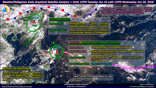
Tuesday, June 19 2018: Good afternoon. We’ve had a cloudy day all day long, though they were light clouds. We’re now experiencing some afternoon thunderstorm activity due to the trough associated with LPA 97W. The storms should end by 9PM to 10PM.
We can expect almost the same thing tomorrow: thunderstorms between 3PM and 7PM. Thursday will bring a fairly high chance of a mid-afternoon thunderstorm between 2PM and 4PM but will otherwise be OK, while Friday and Saturday will be fairly nice with only slight chances of scattered showers. On Sunday there’ll be around a 50% chance of scattered showers all day long, with mostly cloudy skies. We’ll get some more rain on Monday as well. So altogether, it looks like not too awful bad of a weekend coming up considering the time of year.
0 notes
Text
Cebu weather, Friday, 15 June
Good morning. We’re having another fine day here in Cebu: enough of a breeze to keep it from getting too hot, blue sky with a handful of small, scattered clouds and no rain (only a 10% chance.) This is due to a recently-formed low-pressure area near China which is attracting the southwest monsoon, or habagat, northward over Luzon and away from the central Philippines.
Tomorrow and Sunday will be partly cloudy with a 50% chance of scattered afternoon thundershowers, because of course it will: it’s the weekend. Next Monday and Tuesday will also be partly cloudy but only a 30% to 40% chance of a brief afternoon shower or two.
Next Wednesday is forecast for an 80% chance of rain: scattered morning showers or light rain becoming more widespread in the afternoon and evening, probably due to the return of the monsoon winds to the Visayas.
The computer forecast models show no developing storm systems between now and next weekend.
0 notes
Photo
It’s Friday afternoon and thanks to the SW Monsoon blowing more northward following the tropical storm (which is already east of Taiwan) we’re going to have a pretty nice weekend here for a change. We’ll see warmer days with a mixture of clouds and sunshine and a very low chance of ran (<10%) all weekend long. Enjoy!
It will be pretty nice all next week as well, though with around a 40% chance of an afternoon thunderstorm here and there due to convection caused by the humidity and warmer weather. Yay, it’ll be almost like Indian summer!
We can expect more rainy and cooler days by the end of June as we return to typical rainy season/southwest monsoon weather, with an increasing chance of storms and typhoons from roughly July through November. If we can make it to Christmas without a major typhoon in the Visayas we should be safe for the year, knock on wood. Typhoon Haiyan (locally named Yolanda), a category 5+ supertyphoon, was enough for me: its eye passed just 50KM or so north of my house. We were lucky: it knocked over two or three trees in the neighborhood, is all, and they didn’t cause any damage, and the electricity was only out for about ten hours (which was just a precautionary measure on the part of the power utility to prevent fires and electrocutions caused by any downed lines.) I’ll never forget the way the wind moaned though. My wife said it sounded like a spirit was traveling with the storm and moaning and groaning.
The only major effects on Metro Cebu were an influx of people moving here from Samar and daily 1 hour rotational planned power outages as the high-tension lines from power plants in Leyte and Samar had been knocked down, so there wasn’t quite enough electricity available in Cebu to meet our needs until those, and the damaged power plants themselves, could be replaced or repaired. Those went on for around three months, but we were way better off than the people where the storm first made landfall (Leyte and Samar) who were entirely without power, not to mention housing, cell phone coverage and Internet access, for that many months or longer. (The main problem was that when the storm was headed this way the national weather agency, and also major websites like Weather Underground and AccuWeather, warned about the high rainfall and wind but they never mentioned the storm surge which was something like 8 or 10 meters high (25 to 30 feet.) People who had weathered typhoons in their own houses before had their houses destroyed and ended up with ships sitting in their front yards!)
0 notes
Photo
Another cloudy day in Metro Cebu. Two weather systems around, tropical depression Ewiniar which is near SE China and LPA 90W, named Domeng as it will soon turn into a tropical storm, with a monsoon trough connecting the two. Add the wet southwesterly windflow to the mixture and you get The Rainy Season. (It hasn’t actually rained much the past two to three days though, it’s just been cloudy, very humid and still warm though cooler than in summer.)
This weather pattern will continue for the next several days though with a bit of sunshine now and then next week, along with scattered thunderstorms in the afternoons.
Domeng is expected to curve toward the northeast near the coast of Japan then head eastward out to sea.
0 notes
Photo
Remember last week when I mentioned that the weather forecast computer models were showing a storm system that would move northward while brushing the coast of Luzon? Well, this is it, LPA 90W with a medium chance of gaining strength. It’s now east of Samar and will be bringing rain to the Visayas today and perhaps tomorrow.
0 notes
Photo
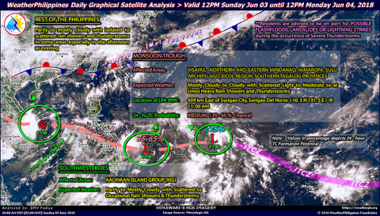
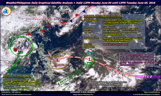
Sunday, June 3 2018: As of 11:00 AM today, LPA 90W was relocated some 659 km East of Surigao City, Surigao Del Norte (10.3N 131.5E), and is forecast to move slowly NNE to Northward across the South Philippine Sea. The potential of 90W of becoming a significant Tropical Cyclone within the next 24 hours remains at MEDIUM (35-65% chance).
Meanwhile, a MONSOON TROUGH which is interconnected between TD 05W and LPA 90W – will bring mostly cloudy to cloudy conditions with scattered light to moderate to at times heavy rain showers and thunderstorms across VISAYAS, NORTHERN AND EASTERN MINDANAO, MIMAROPA, SULU ARCHIPELAGO, BICOL REGION, AND SOUTHERN TAGALOG PROVINCES.
SOUTHWESTERLIES (aka. Southwesterly Surface Windflow) will bring partly to mostly cloudy skies with scattered to occasional rain showers and thunderstorms across THE KALAYAAN ISLAND GROUP (KIG).
The REST OF THE PHILIPPINES will continue to have partly to mostly cloudy skies with isolated to scattered rain showers and thunderstorms in some areas especially in the afternoon or evening.
0 notes
Text
Why do weekends suck?
The forecast is for a 30% chance of scattered showers this morning increasing to 60% this afternoon. The reality is a light, steady rain which will probably continue all weekend, stopping by Sunday evening.
Monday and Tuesday will have a mixture of light clouds and sunshine, while we may see some more rain Wednesday through Saturday especially in the afternoons. Next Sunday looks like it will be sunny and nice (not tomorrow Sunday, next weekend Sunday.) So that gives us two days, Monday and Tuesday, to get caught up on our laundry.
I’ll be cooking my big pot o’ soup today, for sure. It isn’t cold outside, but it isn’t hot either. Soup’s good comfort food on rainy days.
0 notes
Photo
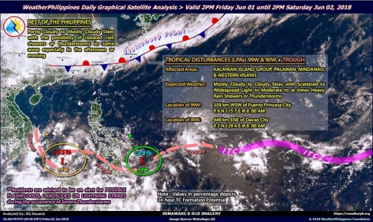
LPA 99W in the Sulu Sea now has a high probability of strengthening into a tropical depression or storm but it’s heading towards China away from the Philippines. LPA 90W, located just west of Mindanao, still has a low probability of organizing into a stronger weather system. But as so often happens, a low pressure trough connecting those two low-pressure areas is what’s causing today’s overcast skies and cooler temperatures and will be the cause of our rainy weekend as both systems move northward taking that trough along for the ride.
We may see some strong local winds due to a nearby thunderstorm but these shouldn’t cause property damage and will just be temporary. This won’t be that bad of a first weather system of the rainy (and typhoon) season, and we can probably use the rain anyway, to raise the water table again after three months of mostly dry, hot weather.
Next week’s forecast shows a return to mostly summer-like weather though with more clouds than we’ve had these past several weeks and some occasional thunderstorm activity. Some days will be cloudy all day long, others will have more sunshine, but, other than perhaps an occasional brief shower here and there, not much rain. I guess this is our Autumn as the weather is similar to that of the very beginning of summer in late February-early March: 20% to 60% chance of scattered thunderstorms but otherwise pretty nice. Usually when the chance of rain is less than 60% it means that there isn’t any, at least not in the Cebu and Mandaue Cities area: unless you happen to be unlucky and end up under a small local thunderstorm, in which case you’ll get dumped on for a brief time, perhaps an hour at the most.
Computer forecast models for the tropical west pacific show a system developing off the east coast of the northern Philippines late next week and organizing into a tropical depression which just grazes the east coast of northern Luzon as it moves northward toward Japan. This system, if it happens, will not affect Cebu.
0 notes
Photo
Today is being surprisingly nice. There will probably be some rain later on tonight between 8PM and midnight though.
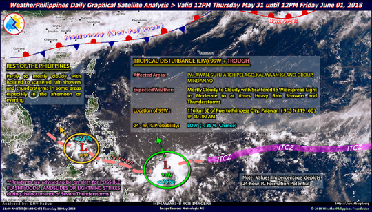
Tomorrow is going to also be pretty nice, but the weekend will be kind of crappy due to LPA 99W heading north, dragging its trough (which is currently over Mindanao) northward over the Visayas along with it. That’s OK, I have the ingredients to make a big pot of homemade soup on Saturday: meaty pork bones, lts of onions and garlic, carrots and small local pechay (that’s baby bok choy to you.) Cool wet days are good soup days.
Just in time to go back to work, next week’s forecast looks not too bad: plenty of clouds but not a lot of rain, with quite a bit of filtered sunshine. It will probably feel very hot though thanks to the humidity.
0 notes
Photo
May 30 2018: Prevailing easterly winds combined with marine cloudiness in the western Pacific will be bringing plenty of clouds our way today and for the next several days, with a high chance (50% to 80%) of showers and thunderstorms through Saturday. We can expect afternoon thunderstorms tomorrow and again Saturday. Sunday will be cloudy but mostly dry. Next week will bring us a mixture of clouds and sunbreaks with occasional to scattered showers now and then.
Computer models are showing a low pressure system or possible storm developing about a week from now but it won’t make landfall in the Philippines as it will be heading northward, staying out over the ocean.
0 notes
Photo
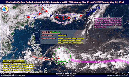
May 28 2018: After days of mixed light clouds and sunshine accompanied by hot, summery temperatures, we’ll be having an increased chance of scattered showers today (50%), mainly in the evening, and will definitely be seeing some rain and possible thunderstorms tomorrow as a weak low pressure area (LPA), the first one of the season, accompanied by its associated trough, affects the Visayas. The pattern of cloudier, rainier weather will continue for the next week. Summer’s over, folks!
0 notes
Photo

May 26 2018: Yesterday afternoon’s rain was due to a wind convergence zone that stretched east-west across the Visayas.
Today returns us to mostly sunny skies and warm temperatures though with a chance of an afternoon convection shower or two. This chance of a spot or two of rain, mostly in the afternoons and evenings, will continue until Tuesday which will be mostly sunny and hot.
0 notes
Text
New platform, new name
I was blogging on Blogspot (see https://cebuweatherblog.blogspot.com/) but have changed to Tumblr. To mark the occasion I have also given it a new name, Cebu Weather Watcher.
As May, and summer, in the Philippines both draw to a close we will start to see increasing chances of stormy weather and even typhoons. I will be presenting forecasts and current information whenever there’s anything to report, and will also try to explain why the weather is (or will be) the way it is.
Mabuhay!
0 notes
Text
New name, new platform
The Cebu Weatherblog has moved from Blogspot.com to Tumblr. To make an occasion out of it I have decided to also rename the blog to Cebu Weather Watch
As May draws to a close so do the summer months (March, April, May) in the Philippines. As the rainy season commences, along with an increased chance of storms and typhoons, I will try to let you know not only what the current conditions and forecast are, but also why.
Mabuhay!
0 notes