
Statistics
We looked inside some of the posts by creativehaus and here's what we found interesting.
Average Info
Notes Per Post
1
Likes Per Post
1
Reblog Per Post
0
Reply Per Post
0
Time Between Posts
4 days
Number of Posts By Type
Text
17
Last Seen Tumblr Blogs


Fun Fact
Tumblr was named as a finalist in Lead411’s New York City Hot 125 in Aug 2010.

Text
QGIS Tutorial

Map by: Cindy Nguyen

Map by: Gustavo Alejandro
0 notes
Text
Bogota: Building a Sustainable City
youtube
The change that Enrique Penalosa envisioned and implemented for Bogota is very inspiring. While he’s humbly noted that Bogota is not a model city yet, we can still learn from the city that a sustainable change can happen if you prioritize the benefits for the people. I loved the idea of changing people’s perspective of public transportation just by simply rebranding the bus into the Transmilenio name. The previous bus system did not feel like it belonged to the citizens, and implementing a new system under Transmilenio gives people the idea that public transportation is for them. Currently, 12% of Bogota population lives in poverty, which means that a majority does not own a car. In addition, many choose not to own a car due to personal reasons. This means that a lot of citizens were not accounted for when the city started to develop for the car and not the people. Penalosa’s plan of building bike lanes and increasing sidewalks gives the land back to the people. This also creates the idea that all people are equal no matter if they are walking, biking or driving. I enjoyed watching this video because it’s a real-life example of the changes that can happen like we’ve been discussing in class. While Bogota still faces many problems, Penalosa’s plan continues to change the city for the better.
Written by: Cindy Nguyen
The changes that Enrique Peñalosa brought to Bogota are a great example of what can be done, to improve the pedestrian experience, when there is an actual effort by the government to help its citizens. In this case, Peñalosa knew the issues that most of the population of Bogota faced daily. He began resolving issues such as heavy congestion, lack of paved roads and sidewalks, and dangers of crossing the street by looking at their transportation system. After that, he pushed to improve sidewalks, create public spaces and parks. Another aspect which one does not always consider is that of gaining the favor of the public opinion, which is important to be able to push these huge projects forward. He did well in coming up with a creative name for the transportation system, which quickly became ingrained in the everyday life of the citizens. And although I agree with was done, he could have handled the modification to store front parking/side walks better. Over all, he did a great job, as mayor of Bogota, to improve the life of the citizens.
Written by: Gustavo Alejandro
The Changes to Bogota brought on by Enrique Peñalosa seem to be working out great. I think it is important to remember that this event only happened because one politician put his desires above that of the public however. In fact there are still many shop keepers had to sacrifice and the general population threatened to impeach him. All This being said I know we as out-siders like the result, but we should think about if we really like the way he made it happen. Its kind of scary that one man can so drastically alter a city, even if we agree with the results.
Written by: Dawson Davis
0 notes
Text
CAPPA Cafe

Shielded in between the Fine Arts and CAPPA building, the CAPPA courtyard is a nice, hidden, green gem within UTA. The area is serene, with the buildings blocking the area from street and traffic noise. Although the large middle green space is occasionally used for social gathering events, often times it is left unused due to being surrounded by circulation paths. Many students do not take advantage of the courtyard space, often hurriedly passing by to get to their destination. Below are possible café ideas designed to invite more students to enjoy CAPPA courtyard.
Current Courtyard


Paws Café


The PAWS Café is a mix-programmatic space where students can study, drink coffee while also playing with therapeutic dogs. One of the most popular UTA events is Paws for Finals, where therapeutic animals are invited to the Central Library during exam week. Students are able to visit and pet the dogs to relieve stress. However, like everyone knows, stress can come at other times than finals, and is also caused by external sources other than finals. Having a permanent space dedicated to the event will allow the animals to visit as they please, giving students more flexible opportunities to relieve stress on a consistent basis. The upper terrace patio has a green turf floor, creating a “park” environment for the animals to play. Leashed animals are also allowed on the ground level of the courtyard. The café is situated in the middle of the courtyard, however, the upper terrace extends to the upper level pathway between CAPPA and Fine Arts. This is because a majority of the circulation in this area is on the upper level, where students hurriedly pass by the courtyard to go in between buildings. Having access on the roof will allow students to enjoy the courtyard space via the upper level. Another reason why the courtyard is not in use often is because of the weather. Being in Texas, weather is finicky, and you get your mixture of rain and sunny skies. The under-passage space created by the extruded upper terrace provides protected space where students can study freely without the concern of rain. In addition, the indoor space is surrounded by a glass-curtain wall, allowing students to study inside while maintaining the view within the courtyard. This also maintains the landscape beauty of the courtyard, without having a disruption by a solid building placed within. Ample seating is provided on the ground floor on the interior and exterior, and also on the upper terrace, allowing more students to enjoy the courtyard space.
Plans, rendering and paragraph written by: Cindy Nguyen
Midnight Café


The Midnight café is a well lit location found at the center of the fine arts and CAPPA courtyard. This is a high-tech, open-air, self-service coffee station which includes places to sit, draw, chat and best of all get coffee! The purpose of this dispensary is to provide a safe place for students to get coffee at any hour of the night, however it also seconds as an excellent place to meet up or just sit and enjoy a lovely day. The Midnight café is completely automatic! The dispensary includes automated walls that shut when the weather becomes unpleasant as well as daylight sensors that adjust lighting to provide safety. It hosts a dispensary system that uses mavs money so all students have to have on them is their ID. By completely automating the coffee buying process for students it will make a safer and less time consuming trip, allowing the students to maintain focus in their valuable midnight hours.
Rendering and paragraph written by: Dawson Davis
Design-Build Café

The Design-Build Café is the coffee shop for architecture students, by architecture students. Instead of encroaching upon the much needed open space of the court yard, this café would be built into the side of the exiting CAPPA building. The kitchen/service area of the café would consist of a remodeled interior section of the CAPPA building. The built structure would consist of a fold-out roof and counter section, designed by students, that would be the store front of the café. By designing the store front in this way, one can go ahead and take advantage of the existing bench area and further activate the pedestrian interaction in the area. Along with this, an additional row of paving would be added to allow for further seating areas, composed of student designed tables and chairs, that would be fully rearrangeable to the convenience of the users. With its position against the CAPPA building, the café would be accessible to all students walking through the courtyard needing a quick cup of coffee. While simple in design, can be a quick, deployable study model that can be modified to the needs of its intended users.

Renderings and paragraph by: Gustavo Alejandro
1 note
·
View note
Text
Housing Projects
The design of housing projects has since evolved from being a high-rise block crammed with basic, modular units. In the examples below, Creative Haus has each explored examples of innovative, common design themes that has been explored over the years.
COURTYARD
A well designed Courtyard is critical to a healthy lifestyle for any building that is larger than single occupancy. A courtyard is an outdoor, enclosed, secure space that is also naturally lit and filled with plants. Such a room helps to blend the edges between the indoors and outdoors, and assist in the relaxation process.
Having a courtyard is necessary for human mental health when living in high density areas. In order for humans to maintain a healthy balance the body must be exposed to the sky and sun on a semi regular basis. When a yard is not available due to restricted land use, a courtyard provides a safe and private room in the house for residents to visually access the benefits of the sun, moon and stars.
Many aspects of human health depend on exposure to sunlight. Depression as well as several skin conditions have been linked to a lack of sun exposure and too much time spent in doors. Therefore, when other forms of outdoor activities are restricted, a courtyard is a must have to maintain the physical and mental health of a resident.
In some cases even if a yard is available sometimes, a courtyard is preferred instead. The primary advantage to a court yard over a regular yard is privacy; a yard is exposed to the view of nosy neighbors while a courtyard is used for private enjoyment. In addition to privacy, a courtyard is much safer than a yard. Yards leave children exposed to the view of shifty neighbors or encounters with wild critters at any time. In opposition, a courtyard serves as an outdoor room to keep belongings such as grills and yard furniture while providing a safe and comfortable place for children to play.
In high-density, low-income-housing courtyards create comfortable spaces. When an individual is restricted to a lifestyle of hard work and tight living, a safe outdoor space helps with relaxation, fresh air, and overall quality of life.
SOURCES:
http://www.home-designing.com/courtyard-design-ideas-tips-pictures-for-inspiration
Pictures and paragraphs written by: Dawson Davis
MODULARITY

Exterior rendering of Hope On Alvarado
Modular architecture consists of a designed system of individual components that can be connected to create different layouts, with the ability to remove or add any number of units without effecting the overall system.
vimeo
Hope On Alvarado is a project by KTGY Architecture + Planning, in which the modular design of single housing units is being taken advantage of to build an affordable housing complex. The driving force behind this project is the increasing homeless population of LA. KTGY Architecture took this in mind and designed something that could be easily constructed, cost effective, and affordable. Parking for this site was built below grade, allowing for pedestrian interaction and mix use units on the ground level, and providing a central, community oriented, courtyard. While most of the initial construction work is done on site, the housing units are built off-site, allowing for a faster overall construction time. The units themselves are studio and single bedroom apartments, with customizable interiors. Hope On Alvarado is the first of a serious of housing projects being constructed in LA, the others being Hope On Broadway and Hope On Hyde Park.
Interior rendering of modular housing unit
SOURCES:
http://ktgy.com/work/hope-on-alvarado/
https://www.forbes.com/sites/juliabrenner/2019/10/30/new-modular-housing-model-tackles-affordable-housing-crisis-in-los-angeles/#2a0d77b87cb5
Pictures and paragraph written by: Gustavo Alejandro
PRE-FAB
youtube


1000m2 Prefabricated Housing is a SUMMARY project that is located in Vale de Cambra, Portugal. SUMMARY’s concept was to create modular, pre-fabricated building systems that was fast, cost effective, and changeable over time.
The ground floor level is reserved for multi-purpose programs and connected with the public place, while the upper levels are 6 individual housing units (45m2 each). Due to the pre-fabrication nature and maximum building area in Portugal, the units were able to be placed at various positions to allow separation between units, which in turn creates individual access entries.

Separation of units allow for individual entries for each unit
The whole building is made up of exposed pre-casted concrete walls, allowing parts to be undefined. This allows flexibility and resource optimization as main themes. In addition, the un-finished material reduces resources and energy applied during the construction process, evidently reducing its environmental impact. This also allows the construction process to be easily assembled in the factory, and then moved to the site.

Pre-casted concrete walls allows for flexible, open interior spaces that is divided by bright yellow colored walls


Flexibility is also exemplified in the ground level, where the above plans are two possible options that the open space can be organized by partitions.
Second level plan showing the placement of modular units
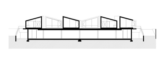
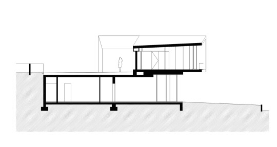
Sections showing relationship between ground and upper levels.
SOURCES:
https://summary.pt/publications/la-biennale-di-venezia/?utm_medium=website&utm_source=archdaily.com
https://www.archdaily.com/938539/1000m2-prefabricated-housing-summary
Pictures and paragraphs written by: Cindy Nguyen
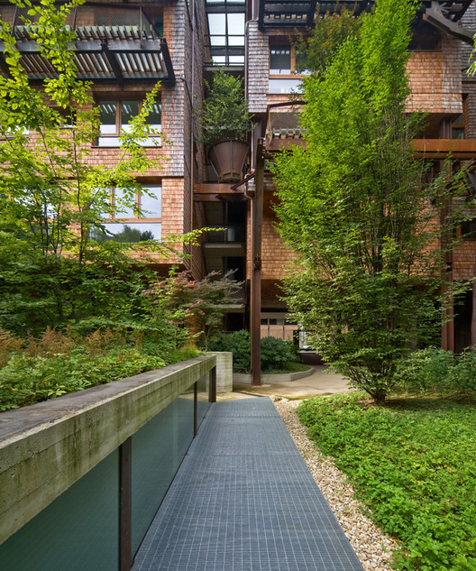
GREEN ECOLOGY
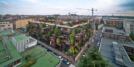
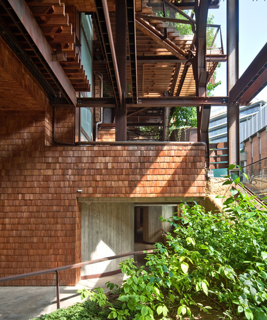
Our last example is housing project, 25 VERDE, located in Turin, Italy. Designed by Luciano Pia and built in 2012, the building has been thought of as a living forest. It is a unique building because it is alive: it grows up, breathes and changes with 150 trees covering its terraces.
The housing, similar to biophilic Singaporean architecture, is covered with green everywhere, whether in big vases on the terraces, court gardens, green walls, or roof gardens.
The project consists of 63 units spanning over 7 floors all in different and fitted shapes with wide, irregular terraces to surround the trees. The highest floor is programmed as private green roofs.
In the courtyard garden, there are 50 trees planted that contributes to the climate by producing oxygen, absorbing carbonic anhydride, cutting down air pollution, and protecting from noise. The trees also follow the cycle of the seasons, growing each day and creating a perfect microclimate inside the building that diminishes the low and high temperatures of summer and wintertime. The steeps in solid wood that floor the terraces filter the sunlight in summer, while in winter they let the light break into the house.
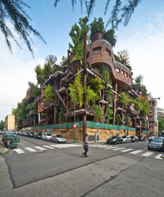
The metal supports look like trees and eventually become entwined with the vegetation to create a unique, growing façade.

One of the aims of the project is the increase of the energetic efficiency and for this reason several integrated solutions have been adopted: continuous insulation, sun protection, heating and cooling systems which make use of the geothermal energy with heat pumps and recycling of the falling rain to water the green.
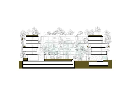
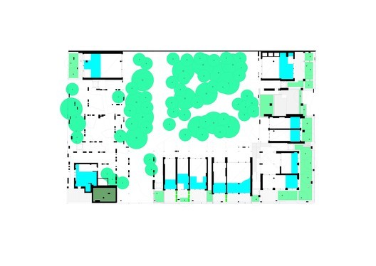
Section and plan showing how the housing units are integrated within the housing “forest”, being separated in the middle by court gardens.
SOURCES:
https://www.archdaily.com/609260/25-green-luciano-pia
0 notes
Text
Confluence Park

Aerial View of Confluence Park

Entrance Rendering of Confluence Park

View from the San Antonio River
Confluence Park, in San Antonio Texas, is a fairly recent example of infrastructural landscape. In this project, a collaboration between Lake/Flato Architects, Matsys and Rialto Studio, the main objective was to create a self-sustainable park highlighting the confluence of the San Antonio river and San Pedro creek, while at the same time creating an educational space meant to inform the public of the South Texas ecosystem. Some of the elements present in this project are storage cisterns for rainwater, collected from the leaf-like pavilion structures. This water is then reused in the park’s irrigation system. Another element present is the green roof of the education and solar panels. The thermal mass from the green roof provides passive temperature control for the education space, while the solar panels collect enough energy to power the entire park.

Diagram of rain collection system
Written by: Gustavo Alejandro
Pictures by: Cindy Nguyen and Joseph Davis
SOURCES:
https://moderninsanantonio.com/confluence-park-confluence-watershed-and-conservation
https://sariverfound.org/confluence-park/
https://www.lakeflato.com/eco-conservation/confluence-park/
https://www.matsys.design/confluence-park
0 notes
Text
Main Street Design
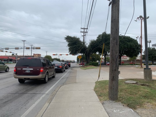
When Americans think of "Main Street", they think of a center of traditional retail consisting of local shops that represents the interests of your everyday citizen and small business owners. Main Street is a common concept that most Americans are aware of. However, over the past few decades, they have been in decline due to the push in favoring automobile transportation, eventually creating strip malls. For this week, Creative Haus went back to the drawing board to re-design our previous site - the southeast corner of Park Row and Cooper in Arlington, TX.
(Site visit pictures are located in previous post)
Location - Cooper and Park Row
UTA/Arlington High Main Street
North Cooper Street - Arlington, TX (Before)
Proposed Main Street Sketch (After)
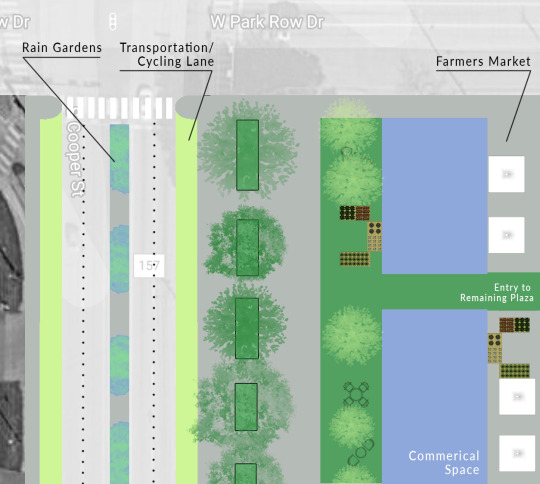
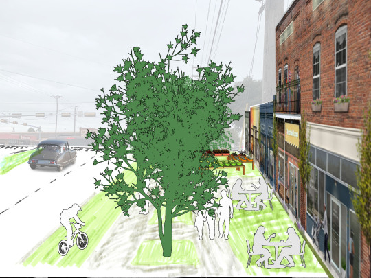
The southeast corner of Park Row and Cooper is currently automobile-focused like the rest of Arlington is. The issue here is that this area has more walkers than other areas throughout Arlington due to being in close proximity to UTA and Arlington High School. The area is dangerous to walkers because they typically have to cross seven lanes of traffic to get from the school to the plaza, and the sidewalks are very close to the streets. Additionally, the strip mall itself is a huge parking lot that is only used partially. The above design gives the land back to the people instead of the automobile. The three-lane traffic going north of Cooper has been turned into two, with the protected right lane being dedicated to bicyclists in addition to public transportation. With the area being in close proximity to UTA, their bus routes can add an additional stop to this area to provide access to services and stores for students, and in turn, bring more density and economic benefit to this area. This intersection has also had its problem with speeders in the area, and their previous ways to resolve it has been lowering the speed limit from 40 to 30, and implementing more police to monitor. However, there are still a lot of speeders in the area due to the wide lanes. The proposal not only dedicates a lane to public transportation, but also narrows the lanes, which has been proven to be safer as cars are inclined to go slower versus faster in wider lanes. The road diet also allows for bigger medians, which are safer for pedestrians. In addition, rain gardens are placed throughout the medians as Arlington’s drainage system are not effective as they should be, causing many streets to lightly flood during rain. The extruded curb at the crosswalks provides a barrier between pedestrians and cars, and allowing vehicles to be able to see walkers easier. Large trees are placed between the sidewalk and street to allow for a physical barrier and reduce traffic noise. The parking lot is converted to commercial lots to give back land for local shops and services such as coffee shops or convenience stores. A permanent spot is reserved for a farmer’s market to provide students easy accessibility to fresh produce, alleviating food deserts for UTA students. The rest of the strip mall is a continuation of my design in “Redesigning Strip Mall” blog, where there are various segmented residential/commercial lots and the concrete area is turned into green space to allow walkability and increase density within the area.
SOURCES:
https://www.wri.org/blog/2016/12/bigger-isnt-always-better-narrow-traffic-lanes-make-cities-safer
Sketch, diagram and paragraph written by: Cindy Nguyen
0 notes
Text
Biophilic Architecture in Singapore
For this week, Creative Haus reacts to Singapore’s Biophilic Architecture in the video below:
youtube
Nowadays we are surrounded by the alarms of irreversible climate change, magnitude of plastic use, and vast extinction of species. All of these are due to humans’ irresponsible impact on the planet, despite our efforts to minimize the changes. Despite all of this, Singapore’s Biophilic architecture stands as a beacon of hope to us all. The idea of integrating urbanism and nature is such a modern and innovative way of living in the future. It amazes me how this complex integration of greenery within the city took years of detailed planning, which shows how far ahead Singapore was designing for. I’d be interested to see in the next decade or so of how they are able to maintain the growing greenery within the city. Or also if they are able to incorporate biophilic architecture into existing buildings (since the examples in the video were fairly new). Nonetheless, Singapore has created this new form of architecture that the world could learn from. While their climate is ideal for biophilic architecture, we could all learn from them in terms of thinking ahead and preparing a sustainable environment for our future.
Written by: Cindy Nguyen
Singapore is an interesting city to study in regards to its response to ecological issues. One of the projects discussed in the video was the Oasia Hotel, which incorporates vegetation onto its exoskeleton-like façade. Not only is vegetation implemented into the building through the façade, but through multiple open spaces throughout the building. These open spaces provide natural air ventilation for the building, and additional spaces for smaller scale landscaping. Such plants as ferns, trees and grasses are seen throughout these area. Although Singapore’s relative closeness to the equator is what allows for these types of vegetation and environments, the concept of incorporating vegetation into the design of the building is some thing that can be applied throughout the globe with vegetation matching the local environment.
Written by: Gustavo Alejandro
0 notes
Text
Arlington Site Visit

The Creativehaus Crew


West Park Row Drive, Arlington TX

South Cooper Street, Arlington TX


North Cooper Street, Arlington TX
0 notes
Text
Slums and Architects
One example to look into is Alejandro Aravena’s firm, Elemental’s work. Their first major project was upgrading slums in Iquique, Chile, which gained them international attention in 2003. The design involved constructing a concrete shell of a middle class house but filling only half the rooms, leaving the other half empty. This was due to the fact that Chile’s government subsides covers construction for only 30-40 sq. meters while their research concluded that families need 70-80 sq. meters of space to inhabit comfortably. This way, families are able to buy houses for $700 and self-build the remaining half. In the end, the completed house can value at $100,00, which could be used for a bank loan or finance to start a business. Aravena believed this could be a “tool to overcome poverty”. In the first project for 100 families, all of the houses have been completed a decade later. I do believe this is a good tool for opportunities for families, however, I do not believe this could be a solution to alleviate slum living in the long-term. Once the house is completed, it would be harder for low socio-economic families to afford, pushing them to live in other spots. However, the firm’s forward thinking and understanding of people living in slums could be a precedent as architects continue to resolve housing issues such as this.

Conceptual diagram showing staggered modules that creates voids to be built later on

Partially completed housing units

Completed self-construction by families a decade later

Before/after of self-construction

Interior before/after of self-construction and inhabitant of families
Photos and paragraph written by: Cindy Nguyen, Gustavo Alejandro, Dawson Davis
SOURCES:
https://www.reuters.com/article/us-latam-housing-architecture/award-winning-architect-builds-half-houses-says-slums-should-inspire-idUSKCN0YI1JG
0 notes
Text
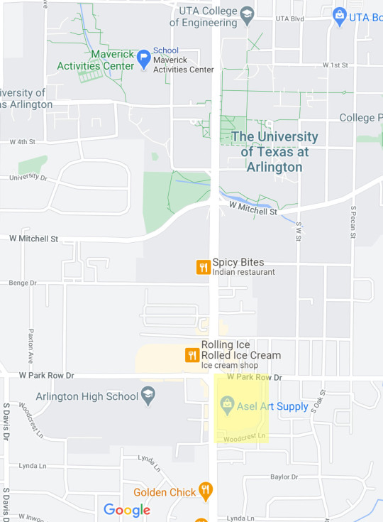
Redesigning Strip Malls
Because Arlington is an automobile-focused area, there are many strip malls throughout the city. Strip malls typically consists of an array of widely stretched stores with a large parking lot placed in front. While this is convenient for the typical car-driver, strip malls are not ideal for urban growth. This week, Creative Haus tackles on the challenge of re-designing a strip mall on the corner of Cooper and Park Row. The corner is in proximity to UT-Arlington and also caters to Arlington High students right across the street. Currently, there is a mixture of services in the plaza, such as restaurants like Subway and Pasta Masta in addition to local stores such as Asel Art Supply and Family Dollar. Because the area is of high use for locals and students, we have proposed the three designs below in effort to re-design the plaza to be more beneficial to locals.
Current Existing Lot - Cooper and Park Row


New Arlington Community


Following a mixture of New Urbanism and TOD principles, the Cooper/Park Row plaza was redesigned to increase walkability within the large, current automobile-focused area. The new layout encourages walkability within the UTA/Arlington community, as this is a popular area where locals such as UTA and Arlington High students walk to throughout the day. The space has roughly 70% reduction of parking. The parking spaces is placed towards the edge of the plaza to increase walkability in the plaza, and encourage patrons to take other modes of transportation such as local UT-Arlington public transit or cycling. The existing commercial lots are redesigned to be a mixed-used space, with housing on top to bring more density within the area. Areas within the plaza marked pink can be used for small shops such as coffee shops, convenience/small grocery stores, or restaurants to provide convenient services and resources to make the area more enjoyable. An array of large trees are placed on the Cooper boundary to act as a boundary and separate the plaza from the busy street.
Map, rendering and paragraph written by: Cindy Nguyen
Artist’s Play Ground


This scheme transforms a dull parking lot like the Asels Art Supply and strip mall into a beautiful meeting place for artists to display their work to the general public. Currently, the prevailing critique of Arlington is their poor pedestrian terrain, with massive amounts of parking far beyond the needed amount.
Step one of this plan is redirecting parking, by creating a bridge on the west and a new protected sidewalk system on the North. Step two, remodel, removing much of the parking and replace it with grassy plots. Step three, add convenient paths while leaving enough parking for disabled individuals nearby. Doing all of these remodels creates a fully accessible park that provides a safe and open grassy area for human interactions.
Map, sketch and paragraph written by: Dawson Davis
Neighborhood Park


The areas around Cooper Street in Arlington are plagued with rundown strip malls and empty parking lots. In this example, I look at the strip mall most frequented by UT Arlington architecture students. While this area does have a nice variety of stores, ranging from art supplies, to restaurants, to clinical services, it is plagued by its large, mostly empty parking lot. In attempt to make this space more inviting and pleasant to be in, I’ve suggested the creation of a small park. This, along with the addition of landscaping and widening of the side walk in front of the stores, will provide a more enjoyable space for locals and could potentially encourage them to visit multiple of the existing stores. By reducing the amount of parking space significantly, pedestrians would be encouraged to use public transit, biking or walking as better alternatives of travel.
Site Diagram, Render and Paragraph by: Gustavo Alejandro
0 notes
Text
Arlington’s Food Deserts

There are 13.5 million people in the United States currently living in food deserts with low access to fresh fruit, vegetables and healthy food. Food deserts are largely caused by a lack of grocery stores, farmers markets and other healthy food providers. Some grocery stores have a difficult time finding investors because it is challenging to prove that a profit will be made in low income areas. Instead, these areas are populated by fast food chains and convenience stores, which often do not provide healthy, nutritious food. Eating highly processed foods on a long-term basis can have negative, harmful effects on the body - leading to diabetes, hypertension and cancer.
It is also difficult for residents to travel to the nearest healthy grocery store. Some families may have to walk miles, and that typically takes all day, which is difficult to do frequently considering the perishable timeframe of fresh produce.
About 20% of residents in Dallas and Tarrant counties live in food deserts with no access to healthy food options. In a survey by Tarrant County Food Policy Council, there are 11 ZIP codes in Tarrant County that are considered food deserts. Zip codes 76013, 76010, 76014 are Arlington’s. UTA, itself, is also experiencing their own food insecurity. While the university is considered a commuter school, there are many students who lives on or nearby campus that does not have easy access to healthy grocery stores. The closest grocery stores is about a mile from campus, making it difficult for students to find the time or transportation to visit these stores.

Zip codes highlighted in purple shows areas that are food deserts
To resolve these food deserts, we have to provide other means of healthy food besides grocery stores. While many currently receive assistance from Tarrant Area Food Bank, CreativeHaus believes there could be other ways to alleviate food deserts. Our proposal is to provide mobile food banks that can setup mini farmer markets in areas with limited food accessibility. These food banks could be sponsored by charities such as Tarrant Area Food Bank and Mission Arlington, or nearby stores such as Whole Foods, Kroger’s and Tom Thumb. For UTA specifically, the places marked (pictured below) are areas with high foot traffic where markets could be setup and provide accessible fresh produce to students. In terms of Arlington, temporary markets could be setup in large parking lots or could be setup within the bus and parked on the street if there isn’t a sizable amount of land to setup markets.

UTA map marked to show areas where potential markets could be setup with high pedestrian traffic


Idea before and after for implementation of a “Farmers Market” Frist Location


Idea before and after for implementation of a “Farmers Market” second location Location


Idea before and after for implementation of a “Farmers Market” Third location Location
Written and Maps by: Cindy Nguyen
Photos and Citations by: Dawson Davis & Gustavo Alejandro
SOURCES:
https://www.uta.edu/news/news-releases/2019/08/05/urban-food-deserts
https://tafb.org/tafb-news/face-of-hunger-in-north-texas/
https://access.tarrantcounty.com/content/dam/main/public-health/12-19-2013FOOD_DESERT_final_report.pdf
Company, The Wendy’s. “Wendy's Brings the Beef to Daley Plaza Farmers Market with Giant Baconator.” PR Newswire: News Distribution, Targeting and Monitoring, 29 June 2018, www.prnewswire.com/news-releases/wendys-brings-the-beef-to-daley-plaza-farmers-market-with-giant-baconator-300321789.html.
“Petaluma Farmers Markets and Farms.” SonomaCounty.com, www.sonomacounty.com/articles/petaluma-farmers-markets-and-farms.
About The Author Shannon I'm Shannon and I love to bake, et al. Killer Bunnies Inc, 7 May 2011, www.killerbunniesinc.com/2011/05/vallco-farmers-market/.
0 notes
Text
Public Transportation for Arlington

Arlington is known to being home to large attractions such as AT&T Stadium, Six Flags/Hurricane Harbor, and Rangers Ballpark. One would think that having these large attractions that brings thousands of people to the city on a frequent basis, Arlington would have a public transit system already in place to facilitate heavy traffic and provide convenient modes of transportation for attendees. However, that is not the case. With a population of about 400,000, Arlington, TX has a reputation for being one of the largest U.S. cities without a mass public transit system.
Why is that? Well, simply put, because residents have voted no for any efforts of public transportation to be implemented. There’s no common reason why public transportation has been rejected. Maybe it’s due to the possibility of increasing taxes, or due to the fact that previous attempts have not been successful, or maybe because Arlingtonians are used to traveling by car that any other way is not feasible. Per DataUSA’s 2018 chart (pictured below), the most common method of travel was by car, whether alone or carpooling.

In 2018, the most common method of travel for workers in Arlington, TX was Drove Alone (82.2%), followed by those who Carpooled (10.7%) and those who Worked At Home (4.3%).

While all of these reasons are valid, the lack of transit is actually more harmful to Arlington. As Arlington’s demographics become increasingly diverse in terms of race and economic status, having a car may not be an affordable option for some. Low-income families are more likely to become financially stable in areas where there is public transportation. Public transportation could also help intrinsically tie UTA students to the community by allowing students to engage more with local businesses. The lack of public transportation can be a deal breaker for prospective students or faculty. A lot of people think that public transportation would rise poverty levels. However, that is not the case. Implementing a public transportation system in Arlington would improve the accessibility of jobs and opportunities for residents.
“Transit brings jobs. Transit brings economic prosperity. Transit brings [a] more lively downtown. People bring more people who are willing to invest in an area. That’s what transit brings to a city.” -Shima Hamidi, UTA Center for Transportation, Equity, Decisions and Dollars Director
Granted, there has been alternative methods such as Via, a ride-hailing service that allows residents to book seats via a smartphone on six-passenger vehicles for $3 per trip. Arlington has also implemented trolleys throughout the AT&T Stadium and Ballpark. Unfortunately, these services are confined to only a portion of Arlington and does not cover its full 99-square miles boundary.

Arlington’s current system only provides transportation to a small portion of the town.
It is time to change the negative stigma of public transportation. While Arlington rapidly grows, cars will soon not be a viable transportation choice. While there are many public transportation options, Arlington should carefully consider a system that is easily reachable within it’s current infrastructure. Creative Haus believes that a combination of light rails and an extensive bus system would be the solution to Arlington’s lack of transportation.

Portland TriMet bus at Gateway Transit Center.
EXTENSTIVE BUS SYSTEM
Because Arlington is very spaced out, there are only a few areas that are highly-concentrated enough to fulfill the demands of subway stops. Buses, on the other hand, can easily disperse citizens throughout many stops in Arlington, dropping off citizens to their destinations within a short walking distance. The bus system would also be reasonable to implement because Arlington’s current infrastructure is automobile-focused. Since we already have the roads, we need to add frequent stops to make the bus system convenient and useable. Arlington should also dedicate designated bus lanes, so reliable buses can run on schedule, creating an alternative mode of transportation during heavy traffic.
For example, Portland’s TriMet has implemented a bus system that is constantly improving to satisfy its citizens’ needs. With 84 bus lines providing frequent service every 15 minutes and some 24-hour routes, Portland has also added designated bus lanes to cut down times during rush hour.

The Rose Lane Project aims to create faster public transportation times by making stretches of congested roads bus-only lanes.
LIGHT RAIL
On average, employees in Arlington, TX have a longer commute time (25.9 minutes) than the normal US worker (25.7 minutes). With that, many citizens commute outside of the city to work, most likely the business centers of Fort Worth and Dallas. Expanding into the Dallas’ DART system, a light rail implemented into Arlington would be ideal because we can continue from an existing system and improve what is already in place. The light rail can act as a connection between Arlington, Fort Worth and Dallas, providing transportation without the headache and stress of traffic. Unlike high speed trains, the light rail is easier to implement more stops, providing accessibility from various areas throughout DFW. It can also be expanded further as in-between cities such as Irving, Grand Prairie, and Frisco grow economically and provide more job opportunities.


While DART is offered only in Dallas and Fort Worth, it would be convenient to expand in Arlington, a town in between the two major cities.
Written by: Cindy Nguyen
Photos: Cindy Nguyen, Gustavo Alejandro, Joseph Davis
SOURCES:
https://www.theshorthorn.com/news/lack-of-mass-transit-hinders-progress/article_6dc2aa3a-4809-11e8-9ef0-c3ad441a2b06.html
https://www.dallasnews.com/news/curious-texas/2019/02/22/arlington-doesn-t-have-a-public-mass-transit-system-so-how-do-you-get-around-curious-texas-investigates/
https://www.arlingtontx.gov/residents/city_services/transportation
https://www.star-telegram.com/opinion/editorials/article195685349.html
https://www.cbsnews.com/news/arlington-texas-experiment-replaces-buses-with-via-partnership/
https://www.wired.com/2013/08/arlington-texas-bus/
https://www.wweek.com/news/city/2019/12/04/portland-bureau-of-transportation-unveils-map-of-20-roads-picked-for-bus-only-rose-lanes/
https://www.star-telegram.com/news/local/arlington/article225513630.html
https://dart.org/maps/printrailmap.asp
0 notes
Text
"The Image of The City"
In the book “Image of The City” written by Kevin Lynch in 1960, the author explores "The Image of The City" through four physical forms, paths, edges, nodes and landmarks.
PATHS
The first and simplest concept from the text is the concept of paths. Paths include all forms of landscape meant for transportation including streets, sidewalks, transit lines, canals and railroads. So, regardless of whether you use a landscape to casually walk from one end of the park to the other exploring wonderful views of nature or are being sped past on a highway throughout the center of the city at 70 miles an hour, both would be examples of paths.

N. Central Expressway, US Highway between downtown Dallas in McKinney Texas

Klyde Warren Park in Dallas
These examples are evidently different, however both of these examples show the passage of people. While some are in cars, some in person, and others are moving from one location to the next being enjoyable or purely functional, both are considered paths.
EDGES
The next concept from "The Image of The City" is the edge. An edge is a space between two other spaces, generally linear boundaries that create a middle ground between two others. Edges often accompany paths but are different due to their nature of being a separation feature, with a main purpose of transportation to and from one location to the next. However, in this case, edges are meant to create a mental reset while traveling across a landscape.
Examples of an edge include everything from arched roads that are meant to separate two bridges to water lines and beaches that distinguish one landscape from another. These intermediate spaces are crucial for the conjoining of landscapes that are essential to create a city.

Trinity River
The Trinity River acts as a barrier between two cityscapes of Dallas' inner city and outer city to create a large segmented space.
Next, there is the concept of districts within the text. All cities have districts, which are explained as a set of buildings that share common characteristics. Characteristics of a district could include function, image, general shape, or even just location (ie. the proximity of buildings located in a downtown city creates a self involved world between those buildings). Generally speaking, a district could be as miniscule as one city block; it's designed in and about itself so that one can maintain a healthy lifestyle while in a single city block. A district however can also be a larger area of space; were many city blocks built to interact with each other they would create a smaller world within the city.

Main Street District
Main Street in Dallas would be an excellent example of a district. Main Street is several city blocks long and just a few blocks wide, showing a self involved world in which an individual could live an entire existence within the designated space while staying rather satisfied. This concept of a smaller world within a city is crucial to any city layout that does not heavily depend on transportation mass transportation. Even cities with mass transportation are seen having similar inner worlds within them.
NODES
The fourth concept that needed explored while viewing "The Image of The City" is the concept of nodes. A node is a strategic location in which a series of buildings and paths are arranged to designate significance to the location. Examples of nodes would include everything from the square nodes of Italy to the dedicated spaces around court houses in Texas.

Founder’s Plaza
In this example of local architecture, we can see streets (acting as paths), landscapes (acting as edges), and buildings (acting as landmarks). Ultimately, these elements are working together to create a center of attention within a city. Essentially, they work together to create a place for people to gather and commune.
LANDMARKS
Finally, the last idea explored in the book is the idea of landmarks. Landmarks are anything that helps a person when navigating, enjoying, or even spectating the city. Examples of this include simple features like an oak tree to more prominent features like the Eiffel Tower.

Dallas The Margaret Hunt Hill Bridge
The Margaret Hunt Hill Bridge is an iconic landmark located in Dallas. The bridge serves several functions of being a reference point, symbol, and physical connection. First, it serves as a point of reference, providing assistance while navigating the city. Secondly, the bridge functions as a recognizable symbol which is unique to Dallas. And lastly, the bridge acts as a pathway that physically connects the different parts of the city.
Written by: Joseph Davis
Photos: Gustavo Alejandro, Cindy Nguyen
SOURCES:
https://www.visitdallas.com/things-to-do/dallas-neighborhoods/west-dallas/trinity-groves.html
https://www.dallasnews.com/news/curious-texas/2019/06/20/why-doesnt-dallas-use-the-trinity-river-as-a-port-curious-texas-investigates/
https://fineartamerica.com/featured/2-main-street-garden-park-in-downtown-dallas-jeremy-woodhouse.html
https://foursquare.com/v/founders-plaza/5186f486498e8b8240d24d93/photos
0 notes
Text
Pacific Plaza

“The street is the river of life of the city...the plaza is the extension of the street”
William H Whyte - The Social Life of Small Urban Space (1980)
This quote applies nicely to one Dallas’ newest parks, Pacific Plaza. Pacific Plaza is located in the downtown area, right down the street from St. Paul station and surrounded by office buildings and high-rises. The plaza creates a nice green area which business people can visit during their lunch break, and which families can visit on sunny weekends. Following some if the points provided by Whyte, Pacific Plaza has the following:
-Sitting Spaces: The plaza has plenty of continues concrete benches curving along the sides of the walkways and also has multiple sets of moveable tables and chairs, encouraging social activity.
-Physical/Visual relationship with the street: One can easily see the streets surrounding the plaza and see across the plaza from the streets. Although there is a slight increase in the elevation of the towards the center, all sides of the plaza are at street level.
-Light: Although it sits surrounded by tall buildings, the plaza gets a good amount of sunlight throughout the day, both directly and indirectly, reflected off of the nearby building facades. And by the end of the day, those same buildings provide a nice covering of shade.
Providing a seamless interaction between the streets and its surroundings, Pacific Plaza manages to become an extension of the street.

Located in downtown Dallas, one of the region's most walkable neighborhoods.

Pacific Plaza was previously parking lots

Complete Streets Manual was implemented to improve design and building of streets to ensure safety and comfort for walkers, motorists, bicyclists, and bus and train riders.

Greenville Avenue: Before Improvement

Greenville Avenue: After Improvement
youtube
CREDITS:
Written by: Gustavo Alejandro
Photos: Joseph Davis
Video and Citations: Cindy Nguyen
SOURCES:
Pacific Plaza Park. (2019, December 21). Retrieved September 22, 2020, from https://en.wikipedia.org/wiki/Pacific_Plaza_Park
Schutze, J., Rogers, T., Heft, E., & Redman, K. (2019, October 13). Downtown Dallas Ready for 'Refuge of Shade' In Soon-To-Open Pacific Plaza. Retrieved September 22, 2020, from https://www.dmagazine.com/frontburner/2019/10/downtown-dallas-ready-for-refuge-of-shade-in-soon-to-open-pacific-plaza/
Transportation. (n.d.). Retrieved September 22, 2020, from https://dallascityhall.com/departments/transportation/Pages/Complete-Streets.aspx
0 notes
Text
The "Ideal” Density
In familiar context, the overall expected average density for single family detached housing in Dallas is 6 units per acre. The existing housing stock is dominated by single-family detached homes, which accounts for over two-thirds of the inventory. In contrast, larger cities, such as New York, consists of multi-family units such as apartments and high-rises, bringing measurements of ~200 units/acre or more.
To paint a clearer picture, Dallas has a population of 1.3 million spanning over ~380 sq. miles, while the 8.4 million population of New York is squeezed into 300 sq. miles. In comparison, the residents of Dallas are more spaced out than New York. However, is that necessarily a good thing? As discussed in class previously, the issue with Dallas is that the infrastructure and spacing mixed with limited transportation forces everyone to drive to destinations. It is inconvenient to walk to places, especially in the warm weather, and public transportation such as DART is not useful due to inconveniently placed stations.

On the other hand, New York has built their infrastructure around public transportation, allowing residents to easily move from Point A to B through the choice of subway, bus, walking and biking. In addition, the incorporation of mixed-use buildings allows convenient and short destinations. New York, however, seems to be too dense and crowded, a common thought when one thinks of the city. With over 6x the population of Dallas in a smaller area, the issue is that NYC has become too congested which creates hygienic and pollution issues.

With both cities being on opposite sides of the spectrum, this brings us to the ideal density of Washington, DC. The city has a population of ~700,000 spanning over 68 sq. miles, bringing the measurement to 21 units/acre. While the population is about half of Dallas, it is in a much smaller plot of land. This ideal density offers infrastructure that is convenient for public and private transportation modes and easily accessible and walk-able destinations without the issues of congestion and pollution from excessive density.

CREDITS:
Written and Photos by: Cindy Nguyen
Photos: Joseph Davis
Photos and Citations: Gustavo Alejandro
SOURCES:
Campanile, C., & Feis, A. (2019, March 25). Let's face it: Everything costs more in NYC. Retrieved September 14, 2020, from https://nypost.com/2019/03/24/lets-face-it-everything-costs-more-in-nyc/
Hetchcock, B. (2018). Education, water, transportation threaten Dallas-Fort Worth's growth streak. Retrieved September 14, 2020, from https://www.bizjournals.com/dallas/news/2018/12/03/education-water-transportation-threaten-dallas.html
Benson, M., Benson, M., Dc, T., & Dolly. (2018, October 01). A Guide to the Best Washington, DC Neighborhoods: Dolly Blog. Retrieved September 15, 2020, from https://dolly.com/blog/best-washington-dc-neighborhoods/
0 notes
Text
Water Recycling
There are two main aspects of good water usage that makes an architectural project more sustainable. The first is the proper use of grey-water.
Grey-water is the water from your bathroom sinks, showers, tubs, and washing machines that may contain traces of dirt, food, grease, hair, and certain household cleaning products. Although grey-water looks unpleasant to drink, it is quite safe for watering plants such as grass, crops or gardens. Grey-water can also be used again to flush toilets if the system is set up correctly.

The second step in water sustainability for an architectural project is finding a way to use rainwater as potable drinking water. Rainwater harvesting systems offer a way to reduce a buildings dependence on the grid, and help a building be self-sustainable.

There are four main points to a good rain harvesting system:
1) Water Quality must be maintained
2) Collection unit must be in an easily accessible space for to water flow
3) Water must be filtered. This can happen through either a naturally simulated system, or through an industrial filter
Natural filtration system

Industrial filterer

4) The water must be kept sealed until drinking to avoid insects and algae build up.
A well designed Architectural project will incorporate both of these systems.

youtube
CREDITS:
Written and Photos: Joseph Davis
Photos and Citations: Gustavo Alejandro
Video: Cindy Nguyen
SOURCES:
“Greywater Reuse.” Greywater Action, 30 Oct. 2018, greywateraction.org/greywater-reuse/.
“The Wetland Machine.” Freshkills Park, 9 July 2009, freshkillspark.org/blog/the-wetland-machine.
“Industrial Water Softeners.” Complete Water Solutions, 12 June 2020, complete-water.com/resources/industrial-water-softeners.
Gilmore, John. “Natural Water Purification Agents to Use after SHTF.” Survivopedia, 16 Feb. 2014, www.survivopedia.com/natural-water-filter/.
0 notes