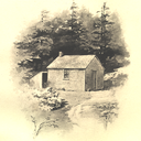
Huts one day apart in the open space around the San Francisco Bay Area
Don't wanna be here? Send us removal request.
Statistics
We looked inside some of the posts by dayapart and here's what we found interesting.
Average Info
Notes Per Post
63K
Likes Per Post
35K
Reblog Per Post
28K
Reply Per Post
169
Time Between Posts
1 month
Number of Posts By Type
Text
10
Photo
7
Last Seen Tumblr Blogs


Fun Fact
Women make up for the other 50% of Tumblr’s audience.
Text

dans ce carrefour qui n’était qu’un infime élément d’un tout constitué de millions de champs carrés et rectangulaires aux cultures répétées, séparés soigneusement par des routes droites strictement parallèles et perpendiculaires, je n’étais qu’un point saisi d'éternité, un simple point qui réglait provisoirement son compte au néant, anéanti par le quadrillage de l'infini
© Pierre Cressant
(mercredi 25 août 2010)
31 notes
·
View notes
Photo

Areas of the World with a Mediterranean Climate According to the Köppen Climate Classification
269 notes
·
View notes
Photo
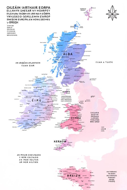
The Celtic Nations with their native place names.
by oglach
10K notes
·
View notes
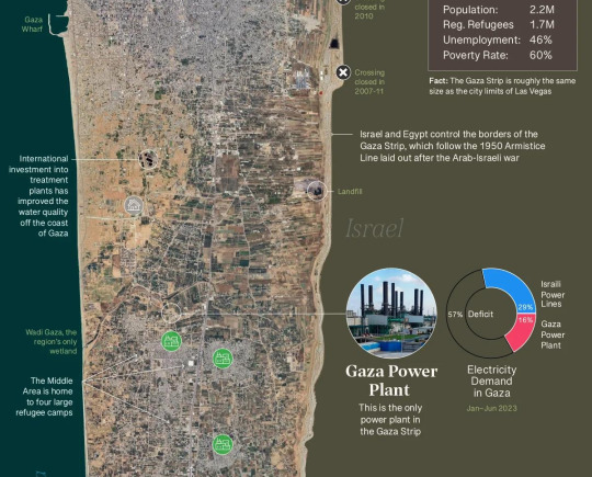
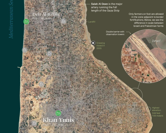
Photo
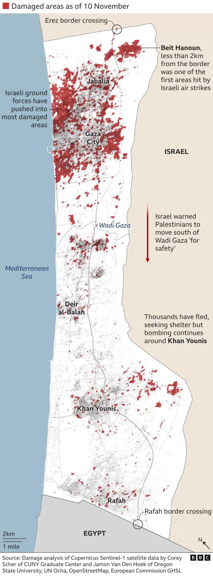
Map of airstrikes’ damage in Gaza, as of 10th of November.
3K notes
·
View notes
Text
Hey All,
I've been away for some time, as we've been working really hard on something quite exciting:
let me present to you the world's first ever global ocean drainage basin map that shows all permanent and temporary water flows on the planet.

This is quite big news, as far as I know this has never been done before. There are hundreds of hours of work in it (with the data + manual work as well) and it's quite a relief that they are all finished now.
But what is an ocean drainage basin map, I hear most of you asking? A couple of years ago I tried to find a map that shows which ocean does each of the world's rivers end up in. I was a bit surprised to see there is no map like that, so I just decided I'll make it myself - as usual :) Well, after realizing all the technical difficulties, I wasn't so surprised any more that it didn't exist. So yeah, it was quite a challenge but I am very happy with the result.
In addition to the global map I've created a set of 43 maps for different countries, states and continents, four versions for each: maps with white and black background, and a version for both with coloured oceans (aka polygons). Here's the global map with polygons:
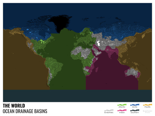
I know from experience that maps can be great conversation starters, and I aim to make maps that are visually striking and can effectively deliver a message. With these ocean drainage basin maps the most important part was to make them easily understandable, so after you have seen one, the others all become effortless to interpret as well. Let me know how I did, I really appreciate any and all kinds of feedback.
Here are a few more from the set, I hope you too learn something new from them. I certainly did, and I am a geographer.
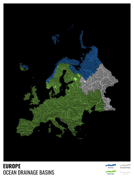
The greatest surprise with Europe is that its biggest river is all grey, as the Volga flows into the Caspian sea, therefore its basin counts as endorheic.
An endorheic basin is one which never reaches the ocean, mostly because it dries out in desert areas or ends up in lakes with no outflow. The biggest endorheic basin is the Caspian’s, but the area of the Great Basin in the US is also a good example of endorheic basins.
I love how the green of the Atlantic Ocean tangles together in the middle.
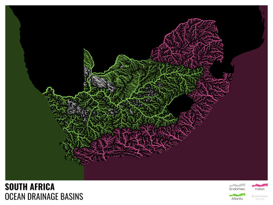
No, the dividing line is not at Cape Town, unfortunately.
I know these two colours weren’t the best choice for colourblind people and I sincerely apologize for that. I’ve been planning to make colourblind-friendly versions of my maps for ages now – still not sure when I get there, but I want you to know that it’s just moved up on my todo-list. A lot further up.
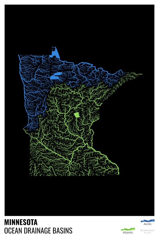
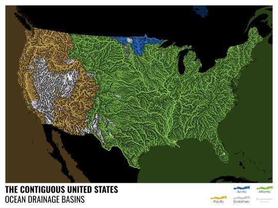
Minnesota is quite crazy with all that blue, right? Some other US states that are equally mind-blowing: North Dakota, New Mexico, Colorado, Wyoming. You can check them all out here.
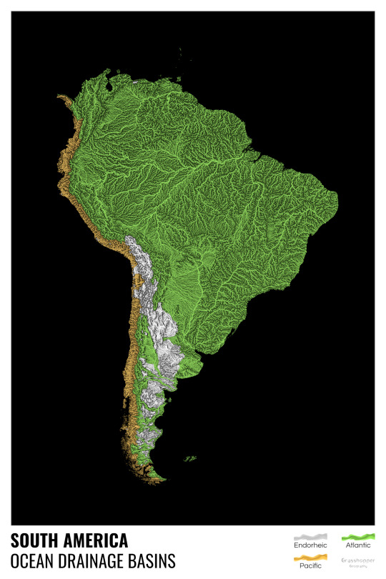
Yes, most of the Peruvian waters drain into the Atlantic Ocean. Here are the maps of Peru, if you want to take a closer look.
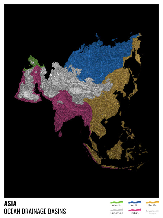
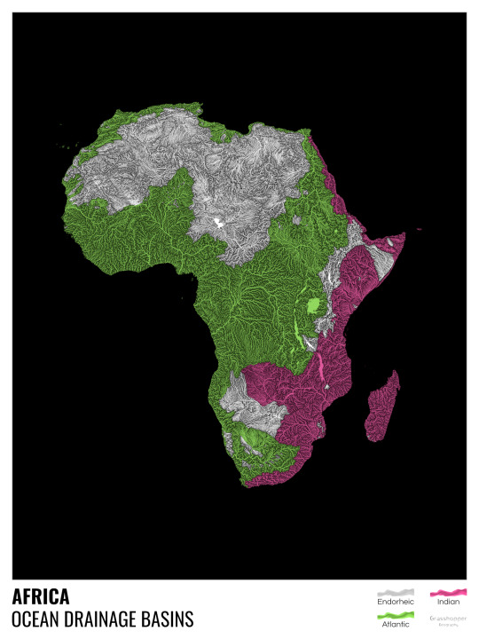
Asia is amazingly colourful with lots of endorheic basins in the middle areas: deserts, the Himalayas and the Caspian sea are to blame. Also note how the Indonesian islands of Java and Sumatra are divided.
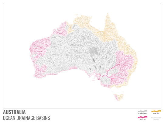
I mentioned earlier that I also made white versions of all maps. Here’s Australia with its vast deserts. If you're wondering about the weird lines in the middle: that’s the Simpson desert with its famous parallel sand dunes.
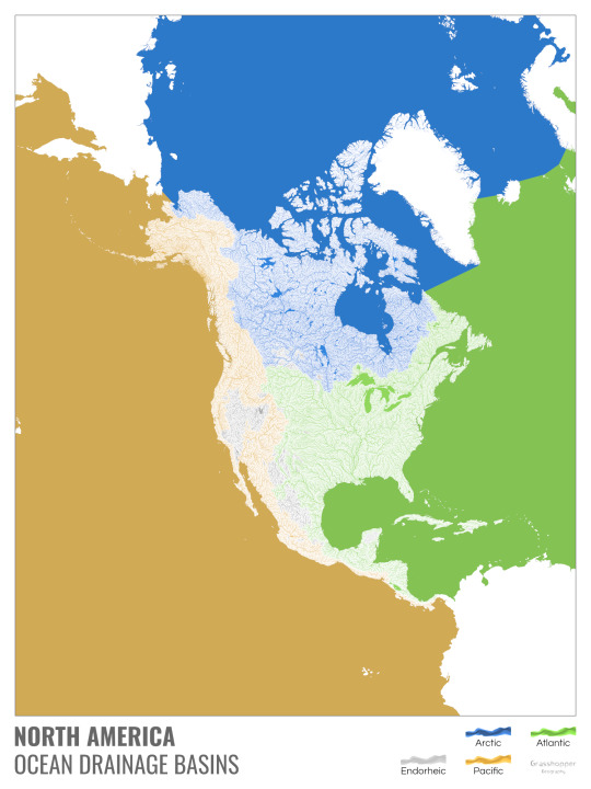
North America with white background and colourful oceans looks pretty neat, I think.

Finally, I made the drainage basin maps of the individual oceans: The Atlantic, the Arctic, the Indian and the Pacific. The Arctic is my favourite one.
I really hope you like my new maps, and that they will become as popular as my river basin maps. Those have already helped dozens of environmental NGOs to illustrate their important messages all around the world. It would be nice if these maps too could find their purpose.
17K notes
·
View notes
Text
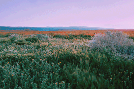
as the wind blows; antelope valley, california
instagram - twitter - website
21K notes
·
View notes
Photo
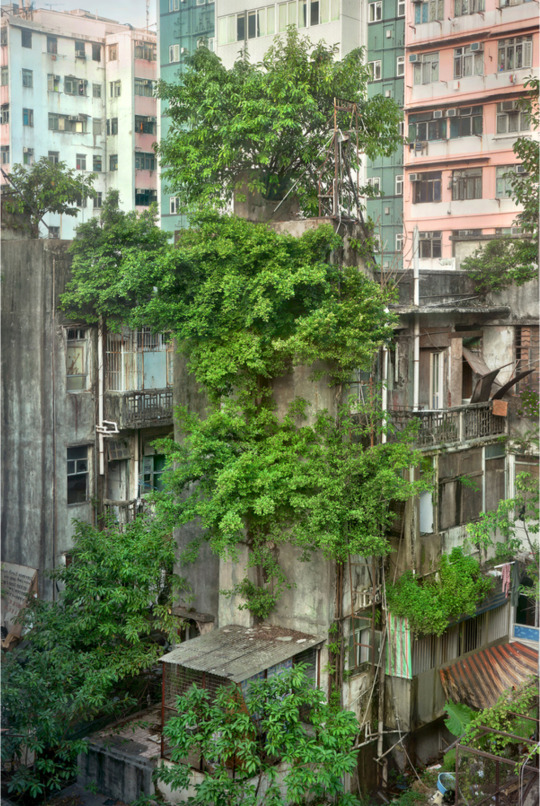
‘Wild Concrete #58’ Hong Kong, 2013. Romain Jacquet-Lagrèze. Chromogenic print. (however long I’ve been posting here, that’s how long every spell checker says ‘chromogenic’ is either not a real word or it’s spelled incorrectly).
5K notes
·
View notes


Text
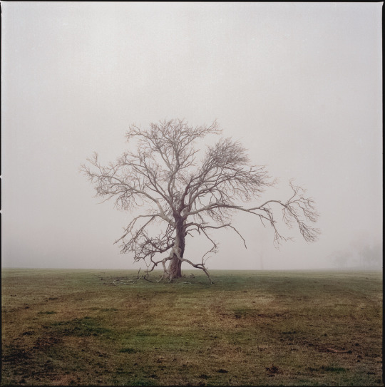
A foggy morning in the midlands of Tasmania, July 2023. Hasselblad 500C/M, Kodak Portra 400.
142 notes
·
View notes
Text

Chimneyspotting.
By Matti Merilaid.
106 notes
·
View notes
Text

Urban composition with red and blue.
By Matti Merilaid.
86 notes
·
View notes


Photo

Sam Coulton, Irradiated Landscapes: Journey to Prospect Cottage https://ajar.arena-architecture.eu/articles/10.5334/ajar.259/
2 notes
·
View notes
Text

Snook, hunting guide, rancher, Wyoming, RA Clayton
20 notes
·
View notes
Text

Carlos Flores
Torrevieja
Provincia de Alicante, Valencia, 1966
192 notes
·
View notes
Photo

Guido Guidi. Fosso Ghaiaia, Italy, 1971.
105 notes
·
View notes