
I enjoy traveling, I love being amidst the serene beauty of nature and capturing it through my lenses gives me immense pleasure. This Page is all about the world i captured through my camera.
Don't wanna be here? Send us removal request.
Statistics
We looked inside some of the posts by ddeka352 and here's what we found interesting.
Average Info
Notes Per Post
0
Likes Per Post
0
Reblog Per Post
0
Reply Per Post
0
Time Between Posts
4 days
Number of Posts By Type
Text
17
Last Seen Tumblr Blogs


Fun Fact
Tumblr has 411 employees.
Text
Dommurok View Point, Markham Village, Markham Valley
Dommurok View Point, Markham Village, Markham Valley Markham Valley, where you may see the undulating hills is Markham Valley, a vantage point from which there is a broad view of the low-lying hills from the hill’s summit. Depending on your luck, just after the rains in the early morning, you can witness a beautiful sight of a cloud formation covering these hills. You will pass by Mawlai Syiem…

View On WordPress
0 notes
Text
BullsTrek Wahniangleng
BullsTrek Wahniangleng BullsTrek Wahniangleng is a Peaceful location with scenic beauty, it is the nearest and cleanest trekking route from shillong, the trek is 1.85kms from parking, it’s a bit rugged so its advice to wear a proper trekking shoes, Its Plastic free area Eco Tourism and well maintained, it has camping sites Kayak and fishing etc. Locals from shillong used to do weekly trek to…

View On WordPress
0 notes
Text
BullsTrek Wahniangleng
BullsTrek Wahniangleng
BullsTrek Wahniangleng is a Peaceful location with scenic beauty, it is the nearest and cleanest trekking route from shillong, the trek is 1.85kms from parking, it’s a bit rugged so its advice to wear a proper trekking shoes, Its Plastic free area Eco Tourism and well maintained, it has camping sites Kayak and fishing etc. Locals from shillong used to do weekly trek to this place as its near scenic clean and burn calories. it’s maintained by locals’ green warriors from the village itself and the fees collected goes to salary of care takers and school fees book fees of the poorest children of this village. Pls don’t bring plastic bags etc.and pls buy from Local people to help them also they are mostly poor and uneducated villagers.

Getting There: The 25 Km journey to Wahniangleng begins in Shillong. Follow the route to Elephant Falls, and from there, take the road to Sohra (Cherrapunji). Look out for Mawjrong, a village located just 2 kilometres before Mawkdok. When you reach Mawjrong, take a right turn, and follow the road until you reach a cemetery on your left. Park your vehicle here and embark on the trek to Wahniangleng.
Footwear: Sturdy trekking or hiking shoes are essential, as the terrain can be rough and occasionally slippery.
Timing: Plan your visit during the daytime, as the meadows and landscapes are best enjoyed in natural daylight.
Weather: Check the weather conditions before your journey, as Meghalaya can experience heavy rainfall, which may affect the accessibility of the trekking path.
0 notes
Text
Dommurok View Point, Markham Village, Markham Valley
Dommurok View Point, Markham Village, Markham Valley
Markham Valley, where you may see the undulating hills is Markham Valley, a vantage point from which there is a broad view of the low-lying hills from the hill’s summit. Depending on your luck, just after the rains in the early morning, you can witness a beautiful sight of a cloud formation covering these hills.

You will pass by Mawlai Syiem on the route to Mawkynrum, which is known for its stunning beauty and has drawn a lot of tourists. The longest paddy field in the West Khasi Hills may be seen in Mawkynrum from a viewpoint perched atop a rock, where a river twists and meanders through the fields. If one wants to stop by the road, Mawlangkhar Green Dunes and Sohwanthiang Falls are right off the highway.
Location: West Khasi Hills District. Distance: 184 km from Guwahati Airport, 97 km from Shillong Airport.
0 notes
Text
Bhairabkunda
Bhairabkunda It is place as if it is set in a canvas perfectly painted with all the colours of nature. A popular picnic spot and owing to its calmness and serenity, the place is visited by couples and families alike. Bhairabkunda is located in Udalguri district in Assam at an elevation of 703 metres, and is close to the Bhutanese town Daifam. It is on the border of Arunachal Pradesh and Bhutan…

View On WordPress
0 notes
Text
Bogamati Baksa
Bogamati Baksa A popular White-Water Rafting spot since 2015, Bogamati is located at the foothills of Bhutan in the Baksa district of Bodoland Territorial Region of Assam. Off-beat cycling, ziplining of 450 meters across the bank of river Barnadi, night camping, jungle hike, rappelling are other activities available at Bogamati. Located near the Indo-Bhutan border, Bogamati lies entirely in the…

View On WordPress
0 notes
Text
Bhalukpung, Sonitpur
Bhalukpung, Sonitpur: In the Indian state of Arunachal Pradesh, Bhalukpong is a small town located in the foothills of the Himalayas. In the Kameng district of Arunachal, this hill station is situated and is also the headquarters of this circle. This place has an altitude of 213 m and is connected to Tezpur, which is only 52 km away. There is also a hill station and tipi, which has one of the…

View On WordPress
0 notes
Text
North Sikkim
North Sikkim: A land – where heaven touches the earth, the ambience creates mystery, a landscape dominated by elements, silence can be heard, vision tends to travel beyond the horizon, soul starts meditating- unknowingly, the mind gets rejuvenated; and land that makes you bow.North Sikkim is the northern district of Sikkim. Mongan is the district headquarter of the district. At an altitude of…

View On WordPress
0 notes
Text
All About Deepor Beel,
All About Deepor Beel, Assam’s Only Ramsar SiteThe 4.1-square kilometre wetlands of Deepor Beel, the state’s only Ramsar site, has around 200 species of birds and 70 species of migratory birdsThe Deepor Beel Wildlife Sanctuary, in the Kamrup district of the lower Brahmaputra valley, is a perennial freshwater lake on the outskirts of Guwahati, Assam. The state’s only Ramsar site (declared in 2002)…

View On WordPress
0 notes
Text
Rang Ghar:
Rang Ghar: It is known as first Ampitheatre or first Pavilion of Asia. It was built by Swargadeo Promotta Singha in the year 1744 A.D. Its shape is octagonal at base. The building has two storeys. At the roof of the structure is shaped like an inverted royal Ahom long boat where there are the projecting heads of two small MAKARAS or JALAHASTIS facing reverse towards north and south. The Rang…

View On WordPress
0 notes
Text
Panimoor waterfall
Panimoor waterfall: In the North Cachar Hill District of Assam, there is the waterfall of Panimoor which is a famous tourist spot. Situated about 120 km away from Haflong, the Kopili River is obstructed by stones, but yet it turns into a gushing milky white waterfall at this spot called Panimur and is indeed an ethereal beauty. The panoramic view of the scenery attracts a number of nature lovers…

View On WordPress
0 notes
Text
Rajbari or the Cooch Behar Palace
Rajbari or the Cooch Behar Palace is located in the city of Cooch Behar in the East-Indian state of West Bengal. Rajbari is also known as Victor Jubilee Palace and is considered of great historical importance in the country. The palace belongs to the Mantris and is a grand structure that drips elegance from every corner, inside and the outside. Visitors will be awestruck right from the moment…

View On WordPress
0 notes
Text
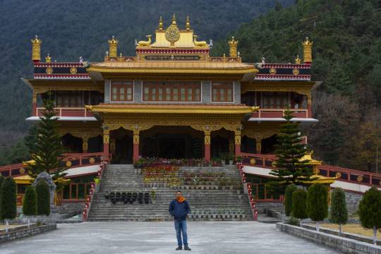
Dirang Monastery
Dirang Monastery is Thupsung Dhargey Ling Monastery, and is certainly one of the most beautiful Monastery in Arunachal Pradesh This Monastery is in fact a learning institute for the study of Tibetian Buddhism by monks and other people. The name “Thupsung Dhargey Ling ” was given by His Holiness Dalai Lama, which means the place of flourishing of Buddha’s speech. Best time to visit We visited…
View On WordPress
0 notes
Text
Naakkati Hills (Cutting Nose)
Naakkati Hills (Cutting Nose): Nakkati is a local name in Assamese language which means “Cutting Nose”. There are so many local stories related to the hill and people of the locality believe Maa Maharani (Goddess Parvati) had mythological relation with this hill; they also built a temple of the goddess in the village. The cliff of Nakkati peak resembles the McAfee peak in USA and the site is…

View On WordPress
0 notes
Text
KOHIMA WAR CEMETERY
KOHIMA WAR CEMETERY: Kohima, the capital city of Nagaland state, is some 200 kilometres from the Indo-Burmese border (now known as the Indo-Myanmar border). Kohima is best reached by air from Calcutta to Dimapur or from Delhi to Dimapur via Gauhati in Assam State and then by a winding road up the mountains. Kohima is 74 kilometres from Dimapur. It can also be reached by road from Gauhati – a long…

View On WordPress
0 notes
Text
UMIAM LAKE
UMIAM LAKE: A tranquil lake at the entrance of Shillong town, a place for watery adventures and relaxing boat rides, a treasure for bird watchers and those who enjoy dramatic scenery. Flanked by hills on all sides and lined by striking roadways and bridges, the gentle Umiam Lake is one of the reasons why the Guwahati-Shillong route is considered one of the most scenic in the region. The lake was…

View On WordPress
0 notes
Text
Bumla Pass
Bumla Pass, situated at an altitude of over 15,000 ft is snowbound for almost the entire year due to its steep elevation and presents a beautiful view of the Tibetan plateau. The road to the pass takes visitors through many sleepy hamlets and scenic lakes, making the drive memorable. Maintained by the Indian Army, Bumla Pass is a must for those who want to see how Indian soldiers protect the…

View On WordPress
0 notes